Victoria Point

Coastal Marsh, Saltings in Cornwall

England

Victoria Point

Tresillian River, St Clement With the tide out, a view across mud to woodland beside Merther Pond.
Tresillian River, St Clement Credit: Andrew Smith

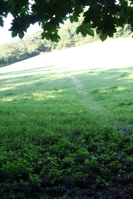
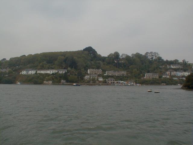
Victoria Point is a picturesque coastal marsh located in Cornwall, England. Situated along the banks of the River Fowey, it is known for its unique ecosystem and stunning natural beauty. This area is commonly referred to as the Saltings due to the presence of salt marshes and mudflats.

The marsh is characterized by its expansive tidal flats, which are exposed during low tides and covered with water during high tides. These intertidal areas are teeming with marine life, attracting a variety of bird species such as oystercatchers, curlews, and herons. The marsh also serves as an important breeding ground for several species of saltmarsh plants, including sea lavender and samphire.

The landscape of Victoria Point is predominantly flat, with patches of tall grasses, reeds, and salt-tolerant plants dotting the marshland. The area is intersected by numerous channels and creeks, forming a complex network that supports a diverse range of aquatic organisms.

The marsh also offers breathtaking views of the surrounding countryside, with rolling hills and fields stretching into the distance. Visitors can enjoy leisurely walks along the designated footpaths that wind their way through the marsh, providing opportunities for birdwatching and observing the unique flora and fauna.

Victoria Point is a tranquil and serene spot, ideal for nature enthusiasts and those seeking solace in the midst of nature. With its rich biodiversity and stunning vistas, the marsh offers a truly immersive experience for anyone visiting Cornwall.

If you have any feedback on the listing, please let us know in the comments section below.

Victoria Point Images

Images are sourced within 2km of 50.243064/-5.0275963 or Grid Reference SW8442. Thanks to Geograph Open Source API. All images are credited.

Tresillian River, St Clement With the tide out, a view across mud to woodland beside Merther Pond.
Tresillian River, St Clement
With the tide out, a view across mud to woodland beside Merther Pond.
Pasture, St Clement Beside the direct footpath between the village and Malpas.
Pasture, St Clement
Beside the direct footpath between the village and Malpas.
Old Kea Church Tower
Menadews Farm, St Clement Viewed from the lane above the village.
Menadews Farm, St Clement
Viewed from the lane above the village.
Meadow to the North of Trennick Lane This Meadow path is the scene of the annual Truro Running Club, Meet Your Max, club run. A lovely canter around the area to the North of the Estuary near Malpas.
Meadow to the North of Trennick Lane
This Meadow path is the scene of the annual Truro Running Club, Meet Your Max, club run. A lovely canter around the area to the North of the Estuary near Malpas.
Tregothnan See <a href="https://www.geograph.org.uk/photo/2671594">SW8541 : Tregothnan</a>.  Viewed from Trelissick Gardens across the River Fal, with laid up shipping in the foreground (see <a href="https://www.geograph.org.uk/photo/2671550">SW8439 : Shipping on the River Fal</a>).
Tregothnan
See SW8541 : Tregothnan. Viewed from Trelissick Gardens across the River Fal, with laid up shipping in the foreground (see SW8439 : Shipping on the River Fal).
Tregothnan The family seat of the Boscowans, Viscount Falmouth.  The house originally dates from 1652, but was rebuilt in the 1820a to a design of William Wilkins, architect also of the National Gallery and buildings at both King's College and Downing College, Cambridge.  Seen here from Trelissick, across the River Fal.  Grade I listed - for listing particulars, see <span class="nowrap"><a title="www.historicengland.org.uk/listing/the-list/list-entry/1141069" rel="nofollow ugc noopener" href="http://www.historicengland.org.uk/listing/the-list/list-entry/1141069">Link</a><img style="margin-left:2px;" alt="External link" title="External link - shift click to open in new window" src="https://s1.geograph.org.uk/img/external.png" width="10" height="10"/></span>.
Tregothnan
The family seat of the Boscowans, Viscount Falmouth. The house originally dates from 1652, but was rebuilt in the 1820a to a design of William Wilkins, architect also of the National Gallery and buildings at both King's College and Downing College, Cambridge. Seen here from Trelissick, across the River Fal. Grade I listed - for listing particulars, see LinkExternal link.
Mouth of Tresillian River
Calenick Creek Swans and geese swimming on a high tide
Calenick Creek
Swans and geese swimming on a high tide
Calenick Creek Swans and geese swimming on a high tide
Calenick Creek
Swans and geese swimming on a high tide
Riverside house at Malpas
St Clement's church, St Clement
Looking upriver to Truro
The road into St Clement At this point, the road drops steeply into the village.  It is marked as a steep hill on OS maps
The road into St Clement
At this point, the road drops steeply into the village. It is marked as a steep hill on OS maps
Village notice board for St Clement A hedge and notice board on the road as it enters the village; plenty of ivy on the trees!
Village notice board for St Clement
A hedge and notice board on the road as it enters the village; plenty of ivy on the trees!
Boats at St Clement and the Tresillian River
St Clement from the waterside
Show me another place!

Victoria Point is located at Grid Ref: SW8442 (Lat: 50.243064, Lng: -5.0275963)

Unitary Authority: Cornwall

Police Authority: Devon and Cornwall

What 3 Words

///tenure.dare.corals. Near Truro, Cornwall

Related Wikis

Malpas, Cornwall

Malpas is a riverside village, and former port, in Cornwall, England, United Kingdom. It is situated two miles (3 km) southeast of the city of Truro, on...

St Anthony Battery

St Anthony Battery is a former 19th century gun battery at St Anthony Head, Roseland Peninsula, Cornwall, England. It was built in 1895-97 and served during...

Old Kea

Old Kea (Cornish: Lanndege) is a hamlet in Cornwall, England, United Kingdom. It is situated on the west bank of the Truro River approximately two miles...

Diocese of Truro

The Diocese of Truro (established 1876) is a Church of England diocese in the Province of Canterbury which covers Cornwall, the Isles of Scilly and a small...

Nearby Amenities

Located within 500m of 50.243064,-5.0275963
Source: PGS
Lat/Long: 50.2426559/-5.0209874
Source: PGS
Lat/Long: 50.2429067/-5.0214284
Source: PGS
Lat/Long: 50.2430254/-5.0220217
Source: PGS
Lat/Long: 50.2429938/-5.0226712
Source: PGS
Lat/Long: 50.2428545/-5.0232822
Source: PGS
Lat/Long: 50.242518/-5.0240563
Source: PGS
Lat/Long: 50.2422017/-5.0247499
Source: PGS
Lat/Long: 50.2421413/-5.0251163
Source: PGS
Lat/Long: 50.2417859/-5.0260079
Source: PGS
Lat/Long: 50.2406211/-5.0279697
Source: PGS
Lat/Long: 50.2403758/-5.0304019
Source: PGS
Lat/Long: 50.2416599/-5.029851
Source: PGS
Lat/Long: 50.241895/-5.0301256
Source: PGS
Lat/Long: 50.2422195/-5.0310998
Source: PGS
Lat/Long: 50.2425664/-5.0317972
Source: PGS
Lat/Long: 50.243081/-5.0332102
Source: PGS
Lat/Long: 50.2433036/-5.034496
Source: PGS
Lat/Long: 50.246555/-5.0318794
Source: PGS
Lat/Long: 50.246193/-5.031579
Source: PGS
Lat/Long: 50.2458946/-5.0312035
Source: PGS
Lat/Long: 50.2452153/-5.0305436
Source: PGS
Lat/Long: 50.2449443/-5.029857
Source: PGS
Lat/Long: 50.2446028/-5.0293989
Source: PGS
Lat/Long: 50.2440128/-5.0291414
Source: PGS
Lat/Long: 50.2434364/-5.0289269
Source: PGS
Lat/Long: 50.2430933/-5.0282402
Source: PGS
Lat/Long: 50.2431652/-5.0275187
Source: PGS
Lat/Long: 50.243165/-5.0267835
Source: PGS
Lat/Long: 50.2440926/-5.0256446
Source: PGS
Lat/Long: 50.2444045/-5.0247509
Source: PGS
Lat/Long: 50.2454967/-5.023821
Source: PGS
Lat/Long: 50.246112/-5.0233649
Bus Stop
Heron Inn
Bus: yes
Naptan AtcoCode: 0800COA15001
Naptan Bearing: SW
Naptan CommonName: Heron Inn
Naptan Indicator: SW-bound
Naptan NaptanCode: cordagpg
Naptan Street: Malpas Road
Naptan Verified: no
Public Transport: platform
Source: naptan_import
Lat/Long: 50.2445837/-5.025208
Malpas
Is In County: Cornwall
Name Kw: Gwanndremen
Place: hamlet
Wikidata: Q6744583
Lat/Long: 50.2458288/-5.0241227
Ferry Terminal
Malpas Ferry Terminal
Ferry: yes
Naptan AtcoCode: 9300MAL
Naptan CommonName: Malpas Ferry Terminal
Naptan RevisionNumber: 0
Naptan Status: new
Naptan StopType: FER
Public Transport: stop_position
Source: naptan_import
Source Date: 2016-07-29
Lat/Long: 50.2433813/-5.0260872
Bus Stop
Victoria Quay
Bus: yes
Naptan AtcoCode: 0800COC30004
Naptan BusStopType: CUS
Naptan NaptanCode: cordagjg
Naptan StopType: BCT
Naptan TimingStatus: OTH
Public Transport: platform
Lat/Long: 50.2433129/-5.0277804
Bus Stop
Victoria Quay
Bus: yes
Naptan AtcoCode: 0800COA15016
Naptan BusStopType: CUS
Naptan NaptanCode: cordagjd
Naptan StopType: BCT
Naptan TimingStatus: OTH
Public Transport: platform
Lat/Long: 50.2433772/-5.0277283
Ferry Terminal
Malpas Ferry Terminal
Ferry: yes
Fixme: Location
Naptan AtcoCode: 9300MAL1
Naptan CommonName: Malpas Ferry Terminal
Naptan RevisionNumber: 0
Naptan Status: new
Public Transport: station
Source: naptan_import
Source Date: 2016-07-30
Lat/Long: 50.2435943/-5.0283733
Post Box
Collection Times: Mo-Fr 09:00; Sa 07:00; Su off
Drive Through: no
Operator: Royal Mail
Operator Wikidata: Q638098
Post Box Mounting: rendered_wall
Post Box Type: wall
Ref: TR1 126D
Royal Cypher: GR
Royal Cypher Wikidata: Q33102273
Source: survey;aerial imagery
Lat/Long: 50.2446324/-5.0251042
The data included in this document is from www.openstreetmap.org. The data is made available under ODbL.

Have you been to Victoria Point?

Leave your review of Victoria Point below (or comments, questions and feedback).