Lurg an Dearg Uillt

Coastal Marsh, Saltings in Argyllshire

Scotland

Lurg an Dearg Uillt

A861, Carnoch
A861, Carnoch Credit: Richard Webb

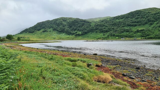
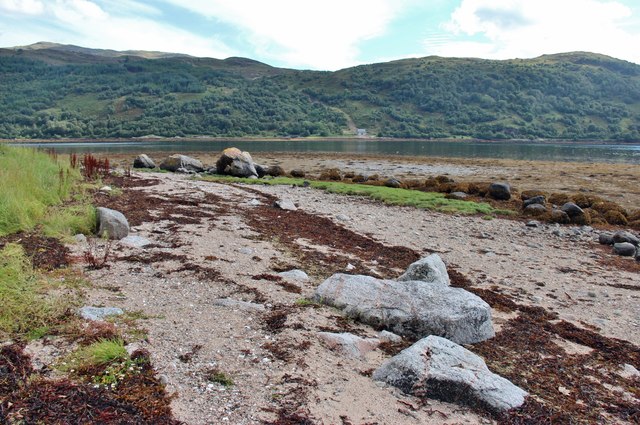
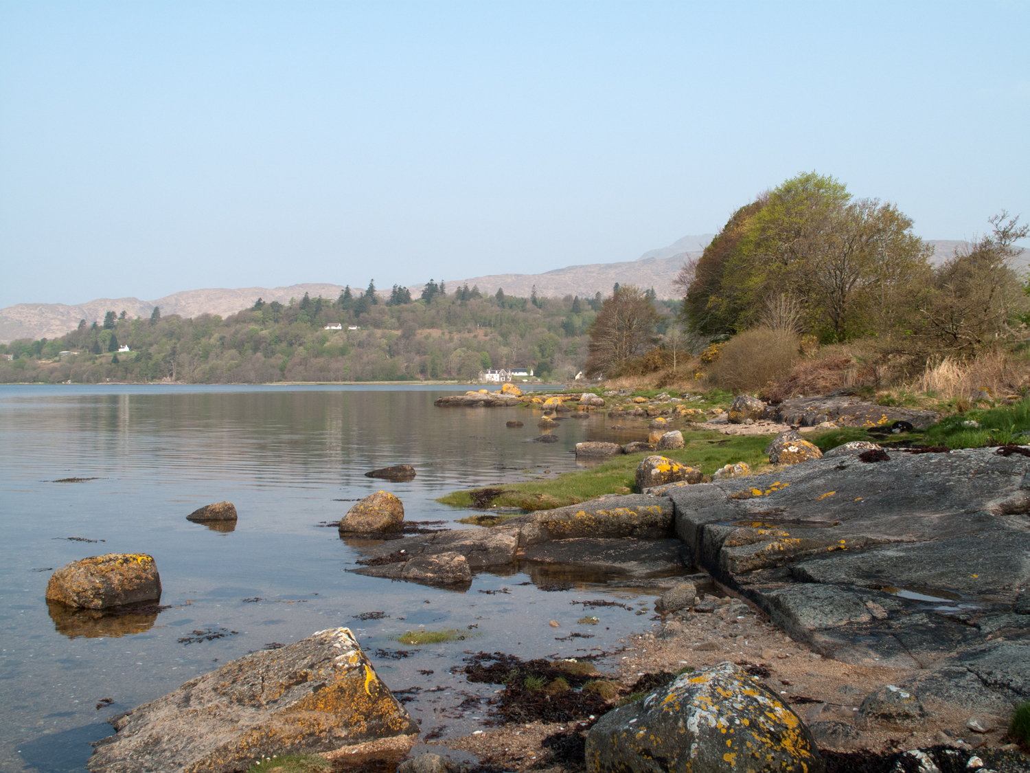
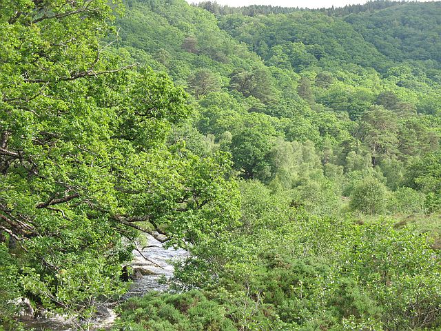
Lurg an Dearg Uillt is a coastal marsh located in Argyllshire, Scotland. It is renowned for its picturesque beauty and the diverse ecosystem it supports. The area is characterized by its vast expanse of salt marshes and saltings, making it a unique and valuable habitat for numerous plant and animal species.

The marshland is located adjacent to the coastline, where the intertidal zone meets the land. This creates a dynamic ecosystem that is influenced by the ebb and flow of the tides. During high tide, the marshes are partially submerged, providing a crucial habitat for various marine organisms such as fish, crustaceans, and mollusks. At low tide, the marshes become a haven for wading birds, including oystercatchers, curlews, and herons, which feed on the exposed mudflats.

The vegetation in Lurg an Dearg Uillt is adapted to the brackish conditions of the marshes. Salt-tolerant plants like sea lavender, sea aster, and thrift can be found flourishing in this environment. These plants stabilize the marshland and provide important food and shelter for the resident and migratory bird populations.

Lurg an Dearg Uillt is not only a haven for wildlife but also a place of natural beauty. The interplay of the marshes, the sea, and the surrounding landscape creates stunning vistas that attract visitors and nature enthusiasts. It is a designated Site of Special Scientific Interest (SSSI) due to its ecological significance and its contribution to the local biodiversity.

Visitors to Lurg an Dearg Uillt can explore the marshes through designated trails and observation points. It offers a unique opportunity to witness the delicate balance of nature and appreciate the wonders of a coastal marsh ecosystem.

If you have any feedback on the listing, please let us know in the comments section below.

Lurg an Dearg Uillt Images

Images are sourced within 2km of 56.68462/-5.5445046 or Grid Reference NM8360. Thanks to Geograph Open Source API. All images are credited.

A861, Carnoch
A861, Carnoch
Achnalea Two houses have been built here recently.
Achnalea
Two houses have been built here recently.
A861 near Carnoch Farm
A861 past the village shop, Strontian
Strontian
Strontian
Head of Loch Sunart
Head of Loch Sunart
Head of Loch Sunart
Head of Loch Sunart
Path behind the shop in Strontian Leading to Dal nan Each and Burnside.
Path behind the shop in Strontian
Leading to Dal nan Each and Burnside.
Strontian village centre
Pottery and Crafts, Strontian A great little shop.  I buy my Mugs there.
Pottery and Crafts, Strontian
A great little shop. I buy my Mugs there.
Old jetty (or ford?) on the River Strontian
A shady green in Strontian
Shore of Loch Sunart
Strontian War Memorial above A861
Path across the green, Strontian
Strontian Shopping Centre Pottery and crafts, Keystore and Cafe Sunart.
Strontian Shopping Centre
Pottery and crafts, Keystore and Cafe Sunart.
Head of Loch Sunart
Head of Loch Sunart
Show me another place!

Lurg an Dearg Uillt is located at Grid Ref: NM8360 (Lat: 56.68462, Lng: -5.5445046)

Unitary Authority: Highland

Police Authority: Highlands and Islands

What 3 Words

///quiz.walked.passion. Near Lochaline, Highland

Nearby Locations

Lurg an Dearg Uillt

Related Wikis

Sunart

Sunart ( SOO-nart, Scottish Gaelic: Suaineart [ˈs̪uəɲərˠʃt̪]) is a rural district and community in the south west of Lochaber in Highland, Scotland, on...

Strontian

Strontian (;Scottish Gaelic: Sròn an t-Sìthein [s̪ɾɔːn̪ˠ ən̪ˠ ˈtʲiː.ɪn]) is the main village in Sunart, an area in western Lochaber, Highland, Scotland...

Ariundle Oakwood

Ariundle Oakwood (Scottish Gaelic: Àirigh Fhionndail, "the shieling of the white meadow") is situated to the north of the village of Strontian in the Sunart...

Scotstown, County Tyrone

Scotstown is a townland in County Tyrone, Northern Ireland. It is situated in the historic barony of Strabane Lower and the civil parish of Urney and covers...

Nearby Amenities

Located within 500m of 56.68462,-5.5445046
Created By: dmgroom_coastlines
Source: PGS
Lat/Long: 56.688266/-5.549243
Created By: dmgroom_coastlines
Source: PGS
Lat/Long: 56.688067/-5.546437
Created By: dmgroom_coastlines
Source: PGS
Lat/Long: 56.68785/-5.544561
Created By: dmgroom_coastlines
Source: PGS
Lat/Long: 56.687751/-5.543157
Created By: dmgroom_coastlines
Source: PGS
Lat/Long: 56.687239/-5.543123
Created By: dmgroom_coastlines
Source: PGS
Lat/Long: 56.687258/-5.542193
Created By: dmgroom_coastlines
Source: PGS
Lat/Long: 56.686998/-5.542409
Created By: dmgroom_coastlines
Source: PGS
Lat/Long: 56.686476/-5.54284
Created By: dmgroom_coastlines
Source: PGS
Lat/Long: 56.686216/-5.543054
Created By: dmgroom_coastlines
Source: PGS
Lat/Long: 56.686362/-5.542133
Created By: dmgroom_coastlines
Source: PGS
Lat/Long: 56.686538/-5.539818
Created By: dmgroom_coastlines
Source: PGS
Lat/Long: 56.685775/-5.539534
Created By: dmgroom_coastlines
Source: PGS
Lat/Long: 56.685652/-5.539293
Created By: dmgroom_coastlines
Source: PGS
Lat/Long: 56.685529/-5.539052
Created By: dmgroom_coastlines
Source: PGS
Lat/Long: 56.685278/-5.538802
Created By: dmgroom_coastlines
Source: PGS
Lat/Long: 56.685259/-5.539732
Created By: dmgroom_coastlines
Source: PGS
Lat/Long: 56.684492/-5.53968
Created By: dmgroom_coastlines
Source: PGS
Lat/Long: 56.684335/-5.541066
Created By: dmgroom_coastlines
Source: PGS
Lat/Long: 56.68407/-5.541513
Created By: dmgroom_coastlines
Source: PGS
Lat/Long: 56.683776/-5.543355
Created By: dmgroom_coastlines
Source: PGS
Lat/Long: 56.683766/-5.543819
Created By: dmgroom_coastlines
Source: PGS
Lat/Long: 56.683748/-5.544749
Created By: dmgroom_coastlines
Source: PGS
Lat/Long: 56.683728/-5.545679
Created By: dmgroom_coastlines
Source: PGS
Lat/Long: 56.683956/-5.54709
Created By: dmgroom_coastlines
Source: PGS
Lat/Long: 56.683946/-5.547555
Created By: dmgroom_coastlines
Source: PGS
Lat/Long: 56.683918/-5.548949
Created By: dmgroom_coastlines
Source: PGS
Lat/Long: 56.683861/-5.551738
Power: pole
Lat/Long: 56.6886723/-5.5464086
Power: pole
Lat/Long: 56.6885898/-5.5450138
Power: pole
Lat/Long: 56.6885353/-5.544118
Power: pole
Lat/Long: 56.6884882/-5.5431846
Power: pole
Lat/Long: 56.6885339/-5.5421439
Power: pole
Lat/Long: 56.6885854/-5.5409476
Power: pole
Lat/Long: 56.6835944/-5.5366212
Power: pole
Lat/Long: 56.6834545/-5.5398399
Power: pole
Lat/Long: 56.6833381/-5.546245
Power: pole
Lat/Long: 56.683562/-5.5498338
Power: pole
Lat/Long: 56.6835222/-5.5515692
The data included in this document is from www.openstreetmap.org. The data is made available under ODbL.

Have you been to Lurg an Dearg Uillt?

Leave your review of Lurg an Dearg Uillt below (or comments, questions and feedback).