Bantam Hole
Coastal Feature, Headland, Point in Kent Dover
England
Bantam Hole
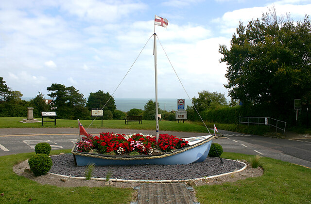
Bantam Hole is a prominent coastal feature located in the county of Kent, England. Situated along the picturesque coastline, it is known for being a headland and a point that juts out into the English Channel. Bantam Hole offers stunning views of the surrounding area and is a popular spot for tourists and locals alike.
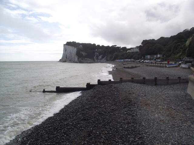
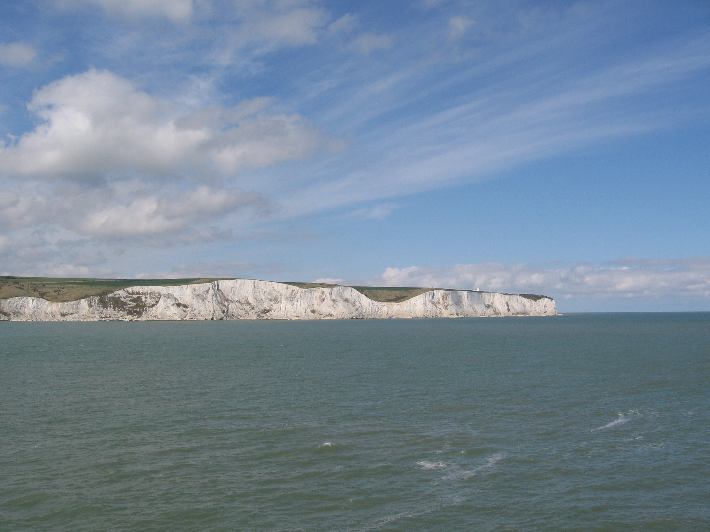
The headland is characterized by its sheer cliffs, which rise up dramatically from the shoreline. These cliffs are composed of various layers of sedimentary rock, showcasing the geological history of the region. Over time, the relentless action of the waves has carved out a small, sheltered cove at the base of the cliffs, creating a picturesque beach.
Bantam Hole is also known for its diverse wildlife. The surrounding waters are home to a variety of marine species, including seals, dolphins, and a wide array of seabirds. This makes it an ideal location for birdwatching and wildlife enthusiasts.
The headland is easily accessible by a well-maintained footpath, which winds its way along the cliff tops. This provides visitors with the opportunity to explore the area and enjoy the breathtaking coastal views. Additionally, there are several picnic areas and benches scattered throughout, allowing visitors to relax and soak in the natural beauty of Bantam Hole.
Overall, Bantam Hole is a captivating coastal feature that offers a mix of stunning landscapes, diverse wildlife, and recreational activities. Whether one is interested in exploring the rugged cliffs, observing the local wildlife, or simply enjoying a peaceful day by the sea, Bantam Hole provides an unforgettable experience for all who visit.
If you have any feedback on the listing, please let us know in the comments section below.
Bantam Hole Images
Images are sourced within 2km of 51.136693/1.365716 or Grid Reference TR3542. Thanks to Geograph Open Source API. All images are credited.


![A walk from St Margaretâs at Cliffe to Kingsdown and return [64] The view from the junction of Granville Road and Hotel Road. Ness Point is seen in the distance.
Starting from the Dover Patrol Monument, the walk follows the long distance Saxon Shore Way along the top of the cliffs before descending to the bay at Kingsdown. Heading inland there is an ascent of Wood Hill before various rights of way run across fields to the wonderfully named Otty Bottom, then on to Free Down and a return to the starting point. A little more than 5 miles.](https://s1.geograph.org.uk/geophotos/07/08/68/7086857_cc6d2c45.jpg)
![St Margaret's at Cliffe buildings [1] Cliffe House, High Street, was built circa 1830. Constructed of painted brick with rendered quoins and a hipped slate roof. Now flats. Listed, grade II, with details at: <span class="nowrap"><a title="https://historicengland.org.uk/listing/the-list/list-entry/1101769" rel="nofollow ugc noopener" href="https://historicengland.org.uk/listing/the-list/list-entry/1101769">Link</a><img style="margin-left:2px;" alt="External link" title="External link - shift click to open in new window" src="https://s1.geograph.org.uk/img/external.png" width="10" height="10"/></span>
St Margaret’s at Cliffe is a coastal village some 3 miles northeast of Dover. The village is the place in Britain that is nearest to the coast of France, 18 miles distant. The area has been settled since Anglo-Saxon times, and the village became a high class resort in the nineteenth century. The area has always been at the front line of cross Channel conflicts.](https://s3.geograph.org.uk/geophotos/07/08/68/7086863_1b38ce43.jpg)
![St Margaret's at Cliffe buildings [2] This large building was originally a series of outbuildings to Cliffe House <a href="https://www.geograph.org.uk/photo/7086863">TR3544 : St Margaret's at Cliffe buildings [1]</a>. Constructed at various dates from the 18th century to the end of the 19th century. Constructed of brick, partly weatherboarded, partly rendered, partly painted, under a mix of slate and tile roofs. Until recently, a hotel, now holiday accommodation. Listed, for group value, grade II, with details at: <span class="nowrap"><a title="https://historicengland.org.uk/listing/the-list/list-entry/1363365" rel="nofollow ugc noopener" href="https://historicengland.org.uk/listing/the-list/list-entry/1363365">Link</a><img style="margin-left:2px;" alt="External link" title="External link - shift click to open in new window" src="https://s1.geograph.org.uk/img/external.png" width="10" height="10"/></span>
St Margaret’s at Cliffe is a coastal village some 3 miles northeast of Dover. The village is the place in Britain that is nearest to the coast of France, 18 miles distant. The area has been settled since Anglo-Saxon times, and the village became a high class resort in the nineteenth century. The area has always been at the front line of cross Channel conflicts.](https://s2.geograph.org.uk/geophotos/07/08/68/7086866_997eeb12.jpg)
![Parish church [1] The Anglican parish church of St Margaret was built circa 1150, replacing an earlier church of which a few fragments remain in the chancel. The tower was added in the late 12th century, and partly rebuilt in 1713. The church was restored in 1864. Constructed of flint and rubble stone under slate roofs, with a tile roof to the south aisle. Listed, grade I, with details at: <span class="nowrap"><a title="https://historicengland.org.uk/listing/the-list/list-entry/1101743" rel="nofollow ugc noopener" href="https://historicengland.org.uk/listing/the-list/list-entry/1101743">Link</a><img style="margin-left:2px;" alt="External link" title="External link - shift click to open in new window" src="https://s1.geograph.org.uk/img/external.png" width="10" height="10"/></span>
St Margaret’s at Cliffe is a coastal village some 3 miles northeast of Dover. The village is the place in Britain that is nearest to the coast of France, 18 miles distant. The area has been settled since Anglo-Saxon times, and the village became a high class resort in the nineteenth century. The area has always been at the front line of cross Channel conflicts.](https://s3.geograph.org.uk/geophotos/07/08/68/7086867_84ca5e88.jpg)
![Parish church [2] The west doorway.
The Anglican parish church of St Margaret was built circa 1150, replacing an earlier church of which a few fragments remain in the chancel. The tower was added in the late 12th century, and partly rebuilt in 1713. The church was restored in 1864. Constructed of flint and rubble stone under slate roofs, with a tile roof to the south aisle. Listed, grade I, with details at: <span class="nowrap"><a title="https://historicengland.org.uk/listing/the-list/list-entry/1101743" rel="nofollow ugc noopener" href="https://historicengland.org.uk/listing/the-list/list-entry/1101743">Link</a><img style="margin-left:2px;" alt="External link" title="External link - shift click to open in new window" src="https://s1.geograph.org.uk/img/external.png" width="10" height="10"/></span>
St Margaret’s at Cliffe is a coastal village some 3 miles northeast of Dover. The village is the place in Britain that is nearest to the coast of France, 18 miles distant. The area has been settled since Anglo-Saxon times, and the village became a high class resort in the nineteenth century. The area has always been at the front line of cross Channel conflicts.](https://s1.geograph.org.uk/geophotos/07/08/68/7086869_d03eaa7e.jpg)
![Parish church [3] A closer look at the west doorway.
The Anglican parish church of St Margaret was built circa 1150, replacing an earlier church of which a few fragments remain in the chancel. The tower was added in the late 12th century, and partly rebuilt in 1713. The church was restored in 1864. Constructed of flint and rubble stone under slate roofs, with a tile roof to the south aisle. Listed, grade I, with details at: <span class="nowrap"><a title="https://historicengland.org.uk/listing/the-list/list-entry/1101743" rel="nofollow ugc noopener" href="https://historicengland.org.uk/listing/the-list/list-entry/1101743">Link</a><img style="margin-left:2px;" alt="External link" title="External link - shift click to open in new window" src="https://s1.geograph.org.uk/img/external.png" width="10" height="10"/></span>
St Margaret’s at Cliffe is a coastal village some 3 miles northeast of Dover. The village is the place in Britain that is nearest to the coast of France, 18 miles distant. The area has been settled since Anglo-Saxon times, and the village became a high class resort in the nineteenth century. The area has always been at the front line of cross Channel conflicts.](https://s0.geograph.org.uk/geophotos/07/08/68/7086872_74a2f93b.jpg)
![Parish church [4] Part of the churchyard.
The Anglican parish church of St Margaret was built circa 1150, replacing an earlier church of which a few fragments remain in the chancel. The tower was added in the late 12th century, and partly rebuilt in 1713. The church was restored in 1864. Constructed of flint and rubble stone under slate roofs, with a tile roof to the south aisle. Listed, grade I, with details at: <span class="nowrap"><a title="https://historicengland.org.uk/listing/the-list/list-entry/1101743" rel="nofollow ugc noopener" href="https://historicengland.org.uk/listing/the-list/list-entry/1101743">Link</a><img style="margin-left:2px;" alt="External link" title="External link - shift click to open in new window" src="https://s1.geograph.org.uk/img/external.png" width="10" height="10"/></span>
St Margaret’s at Cliffe is a coastal village some 3 miles northeast of Dover. The village is the place in Britain that is nearest to the coast of France, 18 miles distant. The area has been settled since Anglo-Saxon times, and the village became a high class resort in the nineteenth century. The area has always been at the front line of cross Channel conflicts.](https://s2.geograph.org.uk/geophotos/07/08/68/7086874_37b12fbe.jpg)
![Parish church [5] Some elaborate tombs in the churchyard.
The Anglican parish church of St Margaret was built circa 1150, replacing an earlier church of which a few fragments remain in the chancel. The tower was added in the late 12th century, and partly rebuilt in 1713. The church was restored in 1864. Constructed of flint and rubble stone under slate roofs, with a tile roof to the south aisle. Listed, grade I, with details at: <span class="nowrap"><a title="https://historicengland.org.uk/listing/the-list/list-entry/1101743" rel="nofollow ugc noopener" href="https://historicengland.org.uk/listing/the-list/list-entry/1101743">Link</a><img style="margin-left:2px;" alt="External link" title="External link - shift click to open in new window" src="https://s1.geograph.org.uk/img/external.png" width="10" height="10"/></span>
St Margaret’s at Cliffe is a coastal village some 3 miles northeast of Dover. The village is the place in Britain that is nearest to the coast of France, 18 miles distant. The area has been settled since Anglo-Saxon times, and the village became a high class resort in the nineteenth century. The area has always been at the front line of cross Channel conflicts.](https://s0.geograph.org.uk/geophotos/07/08/68/7086876_c39546be.jpg)
![St Margaret's at Cliffe buildings [6] Cliffe Cottage, in Cripps&#039; Lane, is an early 19th century house. Constructed of rendered brick under a slate roof. Listed, for group value, grade II, with details at: <span class="nowrap"><a title="https://historicengland.org.uk/listing/the-list/list-entry/1347921" rel="nofollow ugc noopener" href="https://historicengland.org.uk/listing/the-list/list-entry/1347921">Link</a><img style="margin-left:2px;" alt="External link" title="External link - shift click to open in new window" src="https://s1.geograph.org.uk/img/external.png" width="10" height="10"/></span>
St Margaret’s at Cliffe is a coastal village some 3 miles northeast of Dover. The village is the place in Britain that is nearest to the coast of France, 18 miles distant. The area has been settled since Anglo-Saxon times, and the village became a high class resort in the nineteenth century. The area has always been at the front line of cross Channel conflicts.](https://s1.geograph.org.uk/geophotos/07/08/68/7086897_79015766.jpg)
![St Margaret's at Cliffe features [3] The public footpath follows Droveway Gardens and leads to a complex of paths which end at The Droveway or at Kingsdown Road.
St Margaret’s at Cliffe is a coastal village some 3 miles northeast of Dover. The village is the place in Britain that is nearest to the coast of France, 18 miles distant. The area has been settled since Anglo-Saxon times, and the village became a high class resort in the nineteenth century. The area has always been at the front line of cross Channel conflicts.](https://s0.geograph.org.uk/geophotos/07/08/69/7086924_9cd74927.jpg)
![St Margaret's at Cliffe buildings [8] The older buildings of Portal House School, a special needs establishment. See also <a href="https://www.geograph.org.uk/photo/7087754">TR3644 : St Margaret's at Cliffe buildings [9]</a>.
St Margaret’s at Cliffe is a coastal village some 3 miles northeast of Dover. The village is the place in Britain that is nearest to the coast of France, 18 miles distant. The area has been settled since Anglo-Saxon times, and the village became a high class resort in the nineteenth century. The area has always been at the front line of cross Channel conflicts.](https://s1.geograph.org.uk/geophotos/07/08/77/7087753_d367bf55.jpg)
![St Margaret's at Cliffe buildings [9] The newer buildings of Portal House School, a special needs establishment. See also <a href="https://www.geograph.org.uk/photo/7087753">TR3644 : St Margaret's at Cliffe buildings [8]</a>.
St Margaret’s at Cliffe is a coastal village some 3 miles northeast of Dover. The village is the place in Britain that is nearest to the coast of France, 18 miles distant. The area has been settled since Anglo-Saxon times, and the village became a high class resort in the nineteenth century. The area has always been at the front line of cross Channel conflicts.](https://s2.geograph.org.uk/geophotos/07/08/77/7087754_298998af.jpg)
Bantam Hole is located at Grid Ref: TR3542 (Lat: 51.136693, Lng: 1.365716)
Administrative County: Kent
District: Dover
Police Authority: Kent
What 3 Words
///tinny.roses.presumes. Near Dover, Kent
Nearby Locations
Related Wikis

Fan Bay Deep Shelter
Fan Bay Deep Shelter is a series of tunnels constructed during World War II as accommodation for Fan Bay Battery artillery battery, 23 metres down in the...

Preussen (ship)
Preussen (Preußen in German and as written on the vessel) (PROY-sin) was a German steel-hulled, five-masted, ship-rigged sailing ship built in 1902 for...

White Cliffs of Dover
The White Cliffs of Dover are the region of English coastline facing the Strait of Dover and France. The cliff face, which reaches a height of 350 feet...

South Foreland
South Foreland is a chalk headland on the Kent coast of southeast England. It presents a bold cliff to the sea, and commands views over the Strait of Dover...

St Margaret's Bay Windmill
St Margaret's Bay Windmill is a Grade II listed Smock mill on South Foreland, the southeasternmost point of England. It was built in 1929 to generate electricity...
Langdon Bay (Kent)
Langdon Bay is a bay in east Kent, England. It is two miles east of the town of Dover, and is named after the nearby villages of Langdon, East Langdon...

Dover to Kingsdown Cliffs
Dover to Kingsdown Cliffs is a 207.7-hectare (513-acre) biological and geological Site of Special Scientific Interest which runs along the Kent coast between...
RAF Swingate Down
Royal Air Force Swingate Down or more simply RAF Swingate Down is a former Royal Air Force Chain Home Low radar station operational during the Second World...
Nearby Amenities
Located within 500m of 51.136693,1.365716Have you been to Bantam Hole?
Leave your review of Bantam Hole below (or comments, questions and feedback).