Shebirswhilse

Coastal Feature, Headland, Point in Shetland

Scotland

Shebirswhilse

Looking north from path up to Lamb Hoga There is a very good track from the car park beside Fetlar Kirk up onto Lamb Hoga with views to Out Skerries, Bressay and across the whole of Fetlar.  I had assumed that Lamb Hoga would be pronounced as written but oh no, it's pronounced as a single word "Lahmuga" with the stress on the first sylable "Lahm".
Looking north from path up to Lamb Hoga Credit: Mark Stockdale

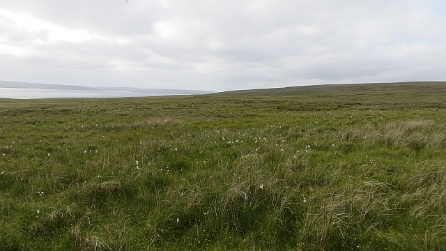
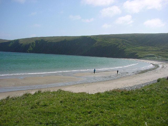
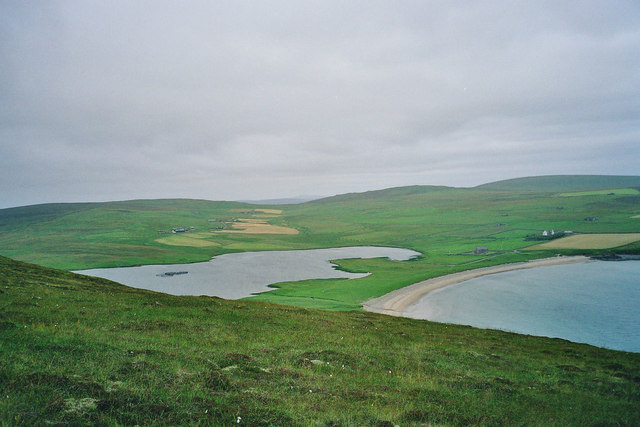
Shebirswhilse is a prominent coastal feature located in the Shetland Islands, an archipelago in Scotland. It is specifically situated on the mainland of Shetland, near the village of Walls. This coastal feature is characterized as a headland or a point, jutting out into the North Atlantic Ocean.

Shebirswhilse offers breathtaking views of the surrounding rugged coastline and the vast expanse of the ocean. Its location makes it an ideal spot for nature enthusiasts, photographers, and birdwatchers alike. The headland is known for its diverse wildlife, with various seabirds nesting in the cliffs and the surrounding area. Visitors can often spot species such as puffins, guillemots, and fulmars.

The coastal feature is also home to a variety of plant life, with heather and wildflowers dotting the landscape. The rocky terrain and crashing waves make it a captivating sight, especially during stormy weather when the waves crash against the cliffs, creating a dramatic display.

Shebirswhilse is a popular destination for hikers and walkers, as it offers a range of walking trails along the coastline. These trails provide an opportunity to explore the area's natural beauty and observe the unique geological formations, including sea stacks and caves.

In summary, Shebirswhilse is a stunning coastal feature on the mainland of Shetland, known for its captivating views, diverse wildlife, and picturesque walking trails. It is a must-visit location for those seeking an immersive experience in the natural wonders of the Shetland Islands.

If you have any feedback on the listing, please let us know in the comments section below.

Shebirswhilse Images

Images are sourced within 2km of 60.58407/-0.91533248 or Grid Reference HU5989. Thanks to Geograph Open Source API. All images are credited.

Looking north from path up to Lamb Hoga There is a very good track from the car park beside Fetlar Kirk up onto Lamb Hoga with views to Out Skerries, Bressay and across the whole of Fetlar.  I had assumed that Lamb Hoga would be pronounced as written but oh no, it's pronounced as a single word "Lahmuga" with the stress on the first sylable "Lahm".
Looking north from path up to Lamb Hoga
There is a very good track from the car park beside Fetlar Kirk up onto Lamb Hoga with views to Out Skerries, Bressay and across the whole of Fetlar. I had assumed that Lamb Hoga would be pronounced as written but oh no, it's pronounced as a single word "Lahmuga" with the stress on the first sylable "Lahm".
The Peat Road The bogs of Lamb Hoga provided Fetlar with high quality fuel. Every year, islanders would move to the peninsula to cast and dry peats. The fuel was then taken off via this road or by boat across to Aith for the eastern side of the island.
 The beach at Tresta is in the background along with Vord Hill.
The Peat Road
The bogs of Lamb Hoga provided Fetlar with high quality fuel. Every year, islanders would move to the peninsula to cast and dry peats. The fuel was then taken off via this road or by boat across to Aith for the eastern side of the island. The beach at Tresta is in the background along with Vord Hill.
Peat Road, Lamb Hoga The route which was used to carry winter fuel off the bogs of Lamb Hoga up to the 1950s.
Peat Road, Lamb Hoga
The route which was used to carry winter fuel off the bogs of Lamb Hoga up to the 1950s.
Bog, Lamb Hoga The west side of Gillis Field which was the source of Fetlar's peat. The moorland is now home to many bonxies and they were pretty mean today.
Bog, Lamb Hoga
The west side of Gillis Field which was the source of Fetlar's peat. The moorland is now home to many bonxies and they were pretty mean today.
The Dale A shallow reentrant on the boggy Lamb Hoga plateau. There is a view over the Wick of Tresta towards Aithbank where peats cut here were once landed.
The Dale
A shallow reentrant on the boggy Lamb Hoga plateau. There is a view over the Wick of Tresta towards Aithbank where peats cut here were once landed.
The Peat Road Lamb Hoga was the source of Fetlar's peat and this was one of the ways the peat was carried to the crofts. Much of the peat was taken out by boat and landed at Airthbank.
The Peat Road
Lamb Hoga was the source of Fetlar's peat and this was one of the ways the peat was carried to the crofts. Much of the peat was taken out by boat and landed at Airthbank.
Mires of Helliersness Peat bogs on Lamb Hoga
Mires of Helliersness
Peat bogs on Lamb Hoga
SW of Tresta towards Silda Wick Looking across the inland end of the Wick of Tresta
SW of Tresta towards Silda Wick
Looking across the inland end of the Wick of Tresta
Papil Water Taken from Fitsyi Field on Lamb Hoga, with Stackaberg (centre) and Vord Hill (right) in the distance.
Papil Water
Taken from Fitsyi Field on Lamb Hoga, with Stackaberg (centre) and Vord Hill (right) in the distance.
Tresta beach, Fetlar The beach at Tresta on Fetlar.
Tresta beach, Fetlar
The beach at Tresta on Fetlar.
The Old Manse, Tresta, Fetlar The old manse has a tree-filled garden and is just above the kirk which is between the Wick of Tresta and Papil Water. The peninsula of Lambhoga is in the distance.
The Old Manse, Tresta, Fetlar
The old manse has a tree-filled garden and is just above the kirk which is between the Wick of Tresta and Papil Water. The peninsula of Lambhoga is in the distance.
The Old Manse, Tresta, Fetlar From the Tresta beach car park, showing the sycamores in the garden.
The Old Manse, Tresta, Fetlar
From the Tresta beach car park, showing the sycamores in the garden.
Tresta beach, Fetlar One of the longest sandy beaches in Shetland.
Tresta beach, Fetlar
One of the longest sandy beaches in Shetland.
Garths of Tresta, Fetlar A creel boat off the small headland to the east of Tresta beach.
Garths of Tresta, Fetlar
A creel boat off the small headland to the east of Tresta beach.
Peat-track from Lambhoga to Tresta, Fetlar The track visible passing through the dunes at the far end of Tresta beach, before heading at an angle up the side of the hill of Fitsyi Field was used by ponies bringing peats from the Lamb Hoga peninsula back to Tresta and other townships.
Peat-track from Lambhoga to Tresta, Fetlar
The track visible passing through the dunes at the far end of Tresta beach, before heading at an angle up the side of the hill of Fitsyi Field was used by ponies bringing peats from the Lamb Hoga peninsula back to Tresta and other townships.
Tresta, Fetlar The small cluster of crofts which form the township of Tresta, from the nearby beach.
Tresta, Fetlar
The small cluster of crofts which form the township of Tresta, from the nearby beach.
Tresta beach, Fetlar A sandy lower beach and stony upper beach.
Tresta beach, Fetlar
A sandy lower beach and stony upper beach.
Papil Water, Fetlar The birds in the centre are non-breeding or off-duty Great Skuas (Stercorarius skua), known as 'Bonxies' in Shetland.
Papil Water, Fetlar
The birds in the centre are non-breeding or off-duty Great Skuas (Stercorarius skua), known as 'Bonxies' in Shetland.
Show me another place!

Shebirswhilse is located at Grid Ref: HU5989 (Lat: 60.58407, Lng: -0.91533248)

Unitary Authority: Shetland Islands

Police Authority: Highlands and Islands

What 3 Words

///tissue.sunset.deflection. Near Houbie, Shetland Islands

Related Wikis

Fetlar

Fetlar (Scots: Fetlar) is one of the North Isles of Shetland, Scotland, with a usually resident population of 61 at the time of the 2011 census. Its main...

Brough Lodge

Brough Lodge is a 19th-century Gothic mansion on Fetlar, one of the Shetland Islands, in northern Scotland. Built by the Nicolson family, who were responsible...

Haltadans

Haltadans, also known as Fairy Ring or Haltadans stone circle, is a stone circle on the island of Fetlar in Shetland, Scotland. This site is a ring of...

Funzie Girt

Funzie Girt (; Scots: Funyie Girt "Finns' dyke") is an ancient dividing wall that was erected from north to south across the island of Fetlar in Shetland...

Hascosay

Hascosay (Scots: Hascosay; Old Norse "Hafskotsey") is a small island lying between Yell and Fetlar in the Shetland Islands, Scotland. == Geography and... ==

Hamars Ness

Hamars Ness is a headland on the island of Fetlar in Shetland, Scotland. The name is from the Old Norse Hamarsnes meaning "craggy headland". A ro-ro ferry...

Urie Lingey

For other islands with similar names, see Linga (disambiguation) Urie Lingey is one of the Shetland Islands. It is between Fetlar and Unst, and Yell is...

Aywick

Aywick is a small settlement on the east side of Yell, an island forming part of the Shetland Islands north of Scotland.The naturalist Bobby Tulloch was...

Have you been to Shebirswhilse?

Leave your review of Shebirswhilse below (or comments, questions and feedback).