Helliera Geo

Coastal Feature, Headland, Point in Shetland

Scotland

Helliera Geo

Fethaland (1) This is Fethaland, a long-abandoned haaf fishing settlement located at the extreme north of Shetland's mainland. (See <span class="nowrap"><a title="https://www.northlinkferries.co.uk/shetland-blog/haaf-fishing-in-shetland/" rel="nofollow ugc noopener" href="https://www.northlinkferries.co.uk/shetland-blog/haaf-fishing-in-shetland/">Link</a><img style="margin-left:2px;" alt="External link" title="External link - shift click to open in new window" src="https://s1.geograph.org.uk/img/external.png" width="10" height="10"/></span> )
Fethaland (1) Credit: Carroll Pierce

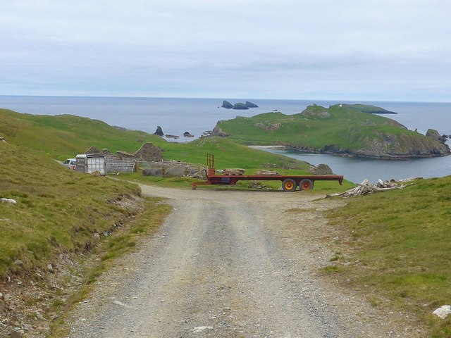
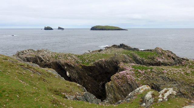
Helliera Geo is a prominent coastal feature located on the west coast of Shetland, an archipelago situated off the north coast of mainland Scotland. This remarkable headland juts out into the North Atlantic Ocean, forming a distinctive point that has captivated visitors and locals alike.

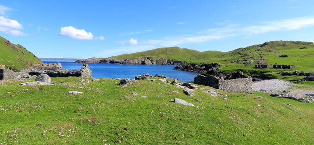
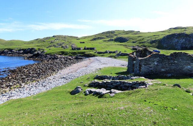
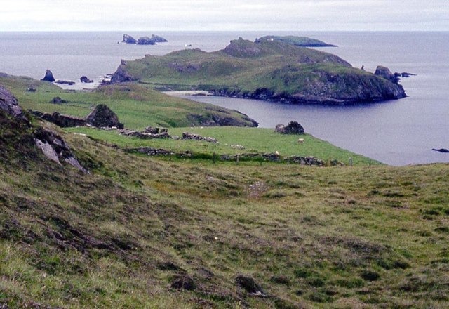
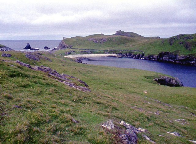
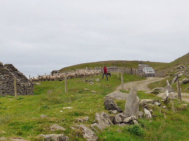
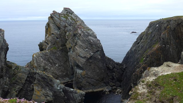
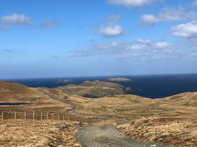
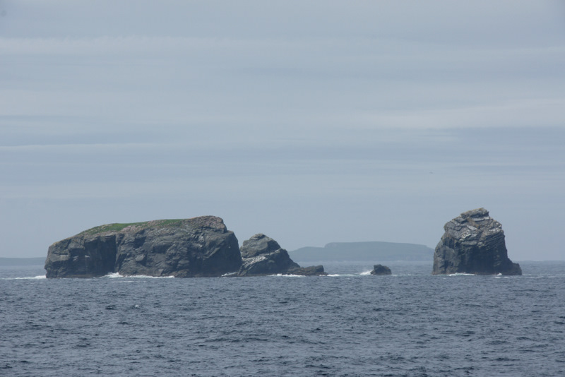
Characterized by its striking cliffs and rugged terrain, Helliera Geo offers breathtaking panoramic views of the surrounding landscape. The cliffs, composed of layered sedimentary rocks, tower over the churning sea below, creating a dramatic and awe-inspiring spectacle. The interplay between the crashing waves, the jagged rocks, and the sheer height of the cliffs adds to the area's wild and untamed beauty.

Helliera Geo is also renowned for its diverse birdlife. The cliffs provide nesting sites for a variety of seabirds, including fulmars, guillemots, and razorbills. These avian creatures can be observed darting through the air or perched on the ledges, making Helliera Geo a popular spot for birdwatchers and nature enthusiasts.

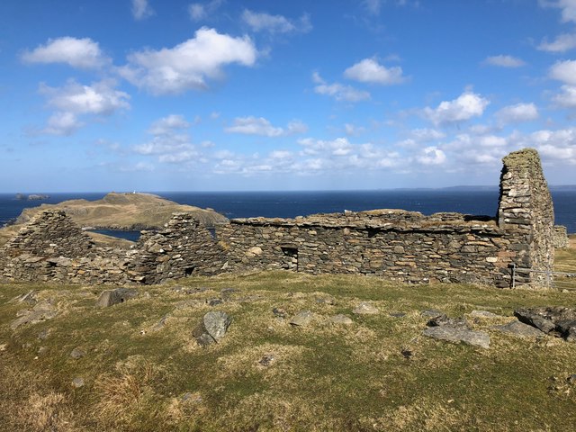
In addition to its natural wonders, Helliera Geo is steeped in history. It is believed that the area has been inhabited since ancient times, with archaeological evidence suggesting human presence dating back thousands of years. The remains of an Iron Age broch, a circular defensive structure, can still be seen on the headland. This historical significance adds another layer of intrigue to this already captivating coastal feature.

Overall, Helliera Geo is a must-visit destination for those seeking a blend of rugged natural beauty, abundant wildlife, and a connection to the past.

If you have any feedback on the listing, please let us know in the comments section below.

Helliera Geo Images

Images are sourced within 2km of 60.624231/-1.3247899 or Grid Reference HU3793. Thanks to Geograph Open Source API. All images are credited.

Fethaland (1) This is Fethaland, a long-abandoned haaf fishing settlement located at the extreme north of Shetland's mainland. (See <span class="nowrap"><a title="https://www.northlinkferries.co.uk/shetland-blog/haaf-fishing-in-shetland/" rel="nofollow ugc noopener" href="https://www.northlinkferries.co.uk/shetland-blog/haaf-fishing-in-shetland/">Link</a><img style="margin-left:2px;" alt="External link" title="External link - shift click to open in new window" src="https://s1.geograph.org.uk/img/external.png" width="10" height="10"/></span> )
Fethaland (1)
This is Fethaland, a long-abandoned haaf fishing settlement located at the extreme north of Shetland's mainland. (See LinkExternal link )
Fethaland (2) This is Fethaland, a long-abandoned haaf fishing community at the very extreme north of Shetland's mainland (see <span class="nowrap"><a title="https://www.northlinkferries.co.uk/shetland-blog/haaf-fishing-in-shetland/" rel="nofollow ugc noopener" href="https://www.northlinkferries.co.uk/shetland-blog/haaf-fishing-in-shetland/">Link</a><img style="margin-left:2px;" alt="External link" title="External link - shift click to open in new window" src="https://s1.geograph.org.uk/img/external.png" width="10" height="10"/></span> ). The stone-lined hollows in the foreground are boat-shaped storage spaces used to house the fishing vessels outside season.
Fethaland (2)
This is Fethaland, a long-abandoned haaf fishing community at the very extreme north of Shetland's mainland (see LinkExternal link ). The stone-lined hollows in the foreground are boat-shaped storage spaces used to house the fishing vessels outside season.
The Isle of Fethaland This is the most northerly point on Shetland Mainland.  It is usually 'not an island', but it can become one if the winds or tides are adverse. It is a walk of about 3.5 km from the nearest road, the north end of the A970, but the track must be reasonable as the lighthouse is clearly reachable by some vehicles.

The pyramidal rock to the left is Yellow Stack. (Perhaps they used Pepsodent?) Beyond it is Gruney, an island with a lighthouse (centre) not recorded on OS maps, with the Ramna Stacks on its left. To the right is the northern part of Yell.
The Isle of Fethaland
This is the most northerly point on Shetland Mainland. It is usually 'not an island', but it can become one if the winds or tides are adverse. It is a walk of about 3.5 km from the nearest road, the north end of the A970, but the track must be reasonable as the lighthouse is clearly reachable by some vehicles. The pyramidal rock to the left is Yellow Stack. (Perhaps they used Pepsodent?) Beyond it is Gruney, an island with a lighthouse (centre) not recorded on OS maps, with the Ramna Stacks on its left. To the right is the northern part of Yell.
Fethaland Ruins at the north tip of Mainland Shetland.
Fethaland
Ruins at the north tip of Mainland Shetland.
Isle of Fethaland The 'Isle' beyond the isthmus is currently a peninsula. No doubt spring tides and storm force winds would make it seem more island-like.
Isle of Fethaland
The 'Isle' beyond the isthmus is currently a peninsula. No doubt spring tides and storm force winds would make it seem more island-like.
Track to the Point of Fethaland The power line is to supply the lighthouse at the point.
Track to the Point of Fethaland
The power line is to supply the lighthouse at the point.
Sheep pens at Breibister And the pens were in use.  The shepherd said that after the prolonged dry spell his sheep "were scouring and he needed to drench them."  His two sheep dogs worked beautifully to gather the flock.  The following day they were all to be on the ferry to Aberdeen for sheep dog trials.
Sheep pens at Breibister
And the pens were in use. The shepherd said that after the prolonged dry spell his sheep "were scouring and he needed to drench them." His two sheep dogs worked beautifully to gather the flock. The following day they were all to be on the ferry to Aberdeen for sheep dog trials.
Sheep pens at Breibister And the pens were in use. The shepherd said that after the prolonged dry spell his sheep "were scouring and he needed to drench them." His two sheep dogs worked beautifully to gather the flock. The following day shepherd and dogs were all to be on the ferry to Aberdeen for sheep dog trials.
Sheep pens at Breibister
And the pens were in use. The shepherd said that after the prolonged dry spell his sheep "were scouring and he needed to drench them." His two sheep dogs worked beautifully to gather the flock. The following day shepherd and dogs were all to be on the ferry to Aberdeen for sheep dog trials.
The Point of Fethaland light This is a white/red sector light flashing white/red every 15 seconds. The black 'boxes' seen in the photo control the direction in which the light shows red and the direction in which it shows white.  A full description is here  <span class="nowrap"><a title="https://www.nlb.org.uk/Navigation/NoticeToMariners/Documents/SHETLAND-ISLES---POINT-OF-FETHALAND/" rel="nofollow ugc noopener" href="https://www.nlb.org.uk/Navigation/NoticeToMariners/Documents/SHETLAND-ISLES---POINT-OF-FETHALAND/">Link</a><img style="margin-left:2px;" alt="External link" title="External link - shift click to open in new window" src="https://s1.geograph.org.uk/img/external.png" width="10" height="10"/></span>
The Point of Fethaland light
This is a white/red sector light flashing white/red every 15 seconds. The black 'boxes' seen in the photo control the direction in which the light shows red and the direction in which it shows white. A full description is here LinkExternal link
Yellow Stack at Point of Fethaland
Stuack and Inner and Outer Booth At Point of Fethaland.  The thrift is growing profusely here.
Stuack and Inner and Outer Booth
At Point of Fethaland. The thrift is growing profusely here.
Gate on the path by the Lower Loch of Setter Through the gate to Sand Voe.
Gate on the path by the Lower Loch of Setter
Through the gate to Sand Voe.
The Lower Loch of Setter
The track to Benigarth and Sand Voe Coming from Lower Loch of Setter.
The track to Benigarth and Sand Voe
Coming from Lower Loch of Setter.
Viga Water Looking north along Viga Water - the sea is just visible on the horizon.
Viga Water
Looking north along Viga Water - the sea is just visible on the horizon.
Landrover Carcass at Loch of Setter End of the road for this one - southern end of Loch of Setter
Landrover Carcass at Loch of Setter
End of the road for this one - southern end of Loch of Setter
Fethaland Vista Looking north down track - Isle of Fethaland and Gruney visible in distance
Fethaland Vista
Looking north down track - Isle of Fethaland and Gruney visible in distance
Ruined Farm Buildings at Breibister
Show me another place!

Helliera Geo is located at Grid Ref: HU3793 (Lat: 60.624231, Lng: -1.3247899)

Unitary Authority: Shetland Islands

Police Authority: Highlands and Islands

What 3 Words

///panic.shipyards.unfocused. Near Ulsta, Shetland Islands

Related Wikis

Fethaland

Fethaland or Fedeland (pronounced [ˈfeɪdələnd]) is an abandoned settlement at the extreme north end of Mainland, Shetland. It was the site of the largest...

Gruney

Gruney is a small, uninhabited island in Shetland, Scotland. It lies north of the Northmavine peninsula of the Shetland Mainland, from which it is separated...

North Roe

North Roe is a village, and protected area at the northern tip in the large Northmavine peninsula of the Mainland of Shetland, Scotland. It is a small...

Ramna Stacks

The Ramna Stacks are a group of skerries in the Shetland islands. They are north of the northern tip of Mainland, and along with nearby Gruney they are...

Nearby Amenities

Located within 500m of 60.624231,-1.3247899
Power: pole
Lat/Long: 60.6259035/-1.3165221
Power: pole
Lat/Long: 60.6247049/-1.3160077
Power: pole
Lat/Long: 60.6240006/-1.3156961
Power: pole
Lat/Long: 60.6253077/-1.3162677
The data included in this document is from www.openstreetmap.org. The data is made available under ODbL.

Have you been to Helliera Geo?

Leave your review of Helliera Geo below (or comments, questions and feedback).