Ness of Houll

Coastal Feature, Headland, Point in Shetland

Scotland

Ness of Houll

Roe Sound and the road to Burn
Roe Sound and the road to Burn Credit: Oliver Dixon

Ness of Houll is a prominent coastal feature located in the northernmost part of the Shetland Islands, Scotland. Situated on the east coast of the Mainland, the largest island in the Shetland archipelago, Ness of Houll is a headland that juts out into the North Sea.

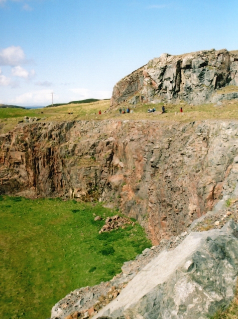
This rugged and picturesque point is characterized by its imposing cliffs, which reach heights of up to 100 feet (30 meters). The cliffs are composed of ancient sedimentary rock formations, displaying layers of sandstone and shale. The unique geology of the area attracts both geologists and nature enthusiasts alike.

Ness of Houll is renowned for its stunning natural beauty and abundant wildlife. The surrounding sea is home to various marine species, including seals and seabirds such as puffins, guillemots, and razorbills. On land, visitors may also spot otters, rabbits, and various species of migratory birds.

The headland offers breathtaking panoramic views of the North Sea and the surrounding coastal landscape. On clear days, it is possible to see nearby islands, such as Out Skerries and Whalsay, as well as the distant horizon.

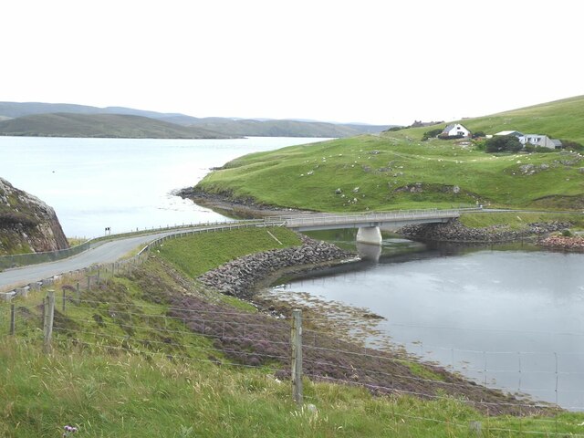
Access to Ness of Houll is possible via a narrow road that winds its way through the rugged terrain. Visitors can park at a designated area and then explore the headland on foot, following a well-defined path that leads to the edge of the cliffs.

Ness of Houll is a must-visit destination for nature enthusiasts and those seeking a tranquil escape in the rugged beauty of the Shetland Islands.

If you have any feedback on the listing, please let us know in the comments section below.

Ness of Houll Images

Images are sourced within 2km of 60.387659/-1.4070626 or Grid Reference HU3267. Thanks to Geograph Open Source API. All images are credited.

Roe Sound and the road to Burn
Muckle Roe Marina The Marina is actually on the Mainland side of Roe Sound. The island of Crog Holm to the left.
Muckle Roe Marina
The Marina is actually on the Mainland side of Roe Sound. The island of Crog Holm to the left.
The Viora (LK177) Six ton shellfish fishing boat at the Muckle Roe Bridge jetty. The road to Brae climbs steeply up the hillside on the far side of the Sound.
The Viora (LK177)
Six ton shellfish fishing boat at the Muckle Roe Bridge jetty. The road to Brae climbs steeply up the hillside on the far side of the Sound.
Fishing paraphernalia  at Muckle Roe Bridge jetty Looking up Roe Sound with the island of Muckle Roe to the left.
Fishing paraphernalia at Muckle Roe Bridge jetty
Looking up Roe Sound with the island of Muckle Roe to the left.
Muckle Roe Bridge The original bridge between Mainland and the island of Muckle Roe (towards camera) was built in 1905, and was replaced in 1999.
Muckle Roe Bridge
The original bridge between Mainland and the island of Muckle Roe (towards camera) was built in 1905, and was replaced in 1999.
Muckle Roe Bridge Linking the Mainland with the island of Muckle Roe. The original bridge was built in 1905, and was replaced in 1999.
Muckle Roe Bridge
Linking the Mainland with the island of Muckle Roe. The original bridge was built in 1905, and was replaced in 1999.
Houses at Busta
Houses at Busta
Rear view of the Busta Hotel The village of Brae <a href="https://www.geograph.org.uk/gridref/HU3567">HU3567</a> on the far side of the voe.
Rear view of the Busta Hotel
The village of Brae HU3567 on the far side of the voe.
The road from Busta to Brae
Kilka Water, Muckle Roe, Shetland Also known as the Glen Loch, this is considered by many to be the best fishing loch on the island of Muckle Roe. The loch is surrounded by rough grazing. This view shows the outlet burn.
Kilka Water, Muckle Roe, Shetland
Also known as the Glen Loch, this is considered by many to be the best fishing loch on the island of Muckle Roe. The loch is surrounded by rough grazing. This view shows the outlet burn.
Busta House Hotel in the snow from Brae
Mavis Grind This is the narrowest land in the British Isles. The inlet on the right is an arm of the Atlantic Ocean; and on the left is Sullom Voe, which is an inlet of the North Sea.
Mavis Grind
This is the narrowest land in the British Isles. The inlet on the right is an arm of the Atlantic Ocean; and on the left is Sullom Voe, which is an inlet of the North Sea.
Bridge to Muckle Roe, Shetland This bridge links the Mainland to Muckle Roe. Photo taken looking south.
Bridge to Muckle Roe, Shetland
This bridge links the Mainland to Muckle Roe. Photo taken looking south.
Muckle Roe Bridge The older bridge to Muckle Roe.
Muckle Roe Bridge
The older bridge to Muckle Roe.
Mavis Grind, Shetland Looking to the west side of Mavis Grind at the Atlantic.
Mavis Grind, Shetland
Looking to the west side of Mavis Grind at the Atlantic.
Mavis Grind, Shetland Looking east at Mavis Grind, the sea is Sullom Voe, part of the North Sea to the east of Shetland.
Mavis Grind, Shetland
Looking east at Mavis Grind, the sea is Sullom Voe, part of the North Sea to the east of Shetland.
Virdins Quarry A large roadmetal quarry, with many veins of red granite cutting the surrounding grey diorite.
Virdins Quarry
A large roadmetal quarry, with many veins of red granite cutting the surrounding grey diorite.
Holm of Culsetter The holm is the tiny island in this voe. In the foreground is a 'roche moutonnée', on which can be seen grooves carved by pebbles under the ice sheet during the last ice age. These grooves, called striae, show the direction of movement of the ice.
Holm of Culsetter
The holm is the tiny island in this voe. In the foreground is a 'roche moutonnée', on which can be seen grooves carved by pebbles under the ice sheet during the last ice age. These grooves, called striae, show the direction of movement of the ice.
Show me another place!

Ness of Houll is located at Grid Ref: HU3267 (Lat: 60.387659, Lng: -1.4070626)

Unitary Authority: Shetland Islands

Police Authority: Highlands and Islands

What 3 Words

///strumming.disband.animals. Near Brae, Shetland Islands

Nearby Locations

Ness of Houll Lothan

Related Wikis

Mavis Grind

Mavis Grind (Old Norse: Mæfeiðs grind or Mæveiðs grind, meaning "gate of the narrow isthmus") is a narrow isthmus joining the Northmavine peninsula to...

Muckle Roe

Muckle Roe is an island in Shetland, Scotland, in St. Magnus Bay, to the west of Mainland. It has a population of around 130 people, who mainly croft and...

Busta Voe

Busta Voe, (HU665350), in the north central Mainland, Shetland, is a sea inlet lying between the village of Brae and the island of Muckle Roe. At the head...

Brae

"Brae" is also the Lowland Scots language word for the slope or brow of a hill.Brae (Old Norse: Breiðeið, meaning "the wide isthmus") is a village on the...

Linga, Busta Voe

Linga is a small, uninhabited island, 1 km (0.62 mi) east of Muckle Roe in the Shetland Islands. The island is roughly circular in shape and its highest...

Papa Little

Papa Little (Scots: Papa Little; Old Norse: Papey Litla, meaning "the little island of the priests") is an island in St Magnus Bay, Shetland, Scotland...

Delting

Delting is a civil parish and community council area on Mainland, Shetland, Scotland. It includes the Sullom Voe oil terminal and its main settlements...

Sullom

Sullom is a village on the Shetland peninsula of Northmavine, between Haggrister and Bardister. It lies on the northwest side of Sullom Voe, to which it...

Have you been to Ness of Houll?

Leave your review of Ness of Houll below (or comments, questions and feedback).