Big Baa Geo

Coastal Feature, Headland, Point in Shetland

Scotland

Big Baa Geo

Qui Ness The grassy headland of Qui Ness can be reached by a narrow, well-worn but rather exposed path over a little neck of land - the sheep and lamb seen in this view have just ventured across to reach the extensive patch of grazing beyond. Either side are two deep geos, both with small stacks within them. The nearer one has a beach and is probably not eroding the link, but the more easterly one will no doubt extend by headward erosion and cut the Ness off to form an island in the near future (by geological time standards). To the right of the photo, Tame Holm has similarly been separated from its headland, West Ness, by a narrow channel of the sort much enjoyed by sea kayakers.

In the distance, the far horizon is formed by Esha Ness and Ronas Hill, whilst the nearer grey cliffs in the centre of the view are the Ness of Hillswick with the dramatic stacks of the Drongs just visible to its west.
Qui Ness Credit: Andy Waddington

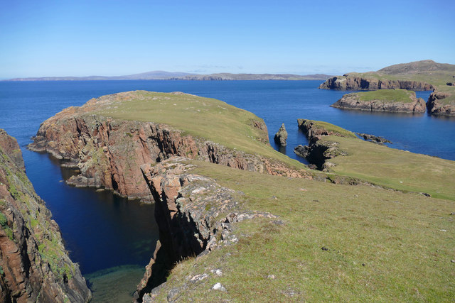
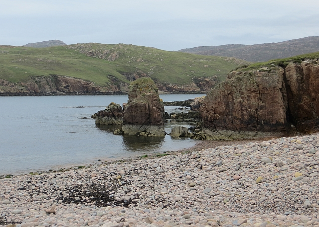
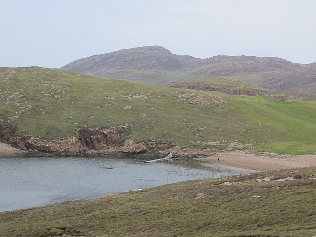
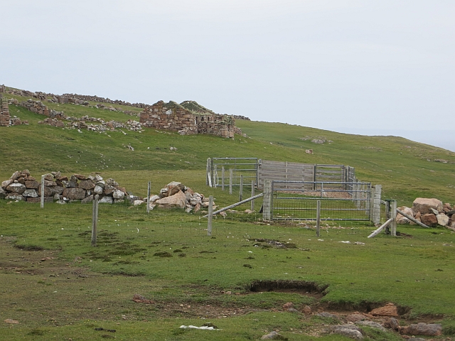
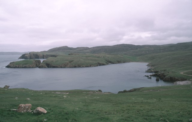
Big Baa Geo is a prominent coastal feature located on the island of Shetland in Scotland. Situated on the west coast of the island, it is a headland that juts out into the North Atlantic Ocean. The name "Big Baa Geo" is derived from the Shetland dialect, with "Geo" referring to a narrow inlet or cove.

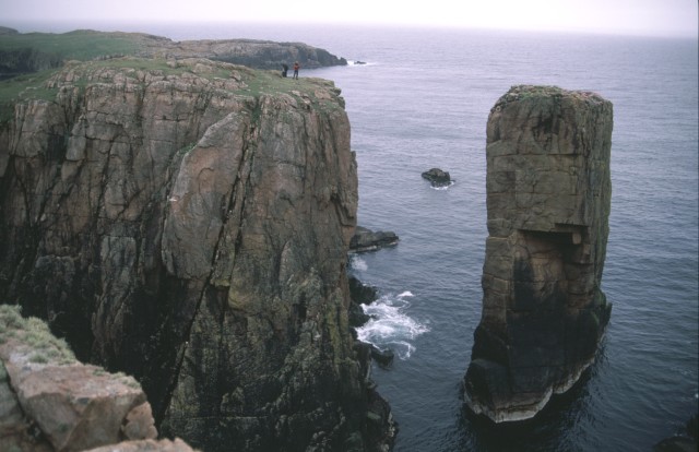
This coastal feature is characterized by its rugged and dramatic cliffs, which reach heights of up to 100 meters (328 feet) above sea level. The cliffs are composed of layers of sedimentary rocks, primarily sandstone and shale, which display unique geological formations and patterns. The exposed rock faces provide an insight into the geological history of the area, with evidence of erosion and weathering over millions of years.

Big Baa Geo is also known for its diverse birdlife. The cliffs provide ideal nesting sites for seabirds such as puffins, guillemots, and razorbills. Visitors to the area can observe these birds in their natural habitat, as well as spot other marine wildlife, including seals and dolphins, in the surrounding waters.

Access to Big Baa Geo is possible via a coastal path that winds along the cliff tops, offering stunning panoramic views of the ocean and the surrounding landscape. The area is popular among hikers, photographers, and nature enthusiasts, who are drawn to its natural beauty and tranquility.

Overall, Big Baa Geo is a remarkable coastal feature that showcases the rugged beauty of Shetland's coastline and provides a haven for diverse wildlife.

If you have any feedback on the listing, please let us know in the comments section below.

Big Baa Geo Images

Images are sourced within 2km of 60.386617/-1.446573 or Grid Reference HU3067. Thanks to Geograph Open Source API. All images are credited.

Qui Ness The grassy headland of Qui Ness can be reached by a narrow, well-worn but rather exposed path over a little neck of land - the sheep and lamb seen in this view have just ventured across to reach the extensive patch of grazing beyond. Either side are two deep geos, both with small stacks within them. The nearer one has a beach and is probably not eroding the link, but the more easterly one will no doubt extend by headward erosion and cut the Ness off to form an island in the near future (by geological time standards). To the right of the photo, Tame Holm has similarly been separated from its headland, West Ness, by a narrow channel of the sort much enjoyed by sea kayakers.

In the distance, the far horizon is formed by Esha Ness and Ronas Hill, whilst the nearer grey cliffs in the centre of the view are the Ness of Hillswick with the dramatic stacks of the Drongs just visible to its west.
Qui Ness
The grassy headland of Qui Ness can be reached by a narrow, well-worn but rather exposed path over a little neck of land - the sheep and lamb seen in this view have just ventured across to reach the extensive patch of grazing beyond. Either side are two deep geos, both with small stacks within them. The nearer one has a beach and is probably not eroding the link, but the more easterly one will no doubt extend by headward erosion and cut the Ness off to form an island in the near future (by geological time standards). To the right of the photo, Tame Holm has similarly been separated from its headland, West Ness, by a narrow channel of the sort much enjoyed by sea kayakers. In the distance, the far horizon is formed by Esha Ness and Ronas Hill, whilst the nearer grey cliffs in the centre of the view are the Ness of Hillswick with the dramatic stacks of the Drongs just visible to its west.
Beach, South Ham A sheltered inlet on the otherwise rugged coast of Muckle Roe. It is also popular with seals.
Beach, South Ham
A sheltered inlet on the otherwise rugged coast of Muckle Roe. It is also popular with seals.
Beach, South Ham The wild coast of Muckle Roe.
Beach, South Ham
The wild coast of Muckle Roe.
Burn of Lairdsloch Granite scenery, Muckle Roe.
Burn of Lairdsloch
Granite scenery, Muckle Roe.
Burg Ruined croft house on the west coast of Muckle Roe.
Burg
Ruined croft house on the west coast of Muckle Roe.
South Ham The photo is taken from an abandoned house - one of several in the area - overlooking South Ham
South Ham
The photo is taken from an abandoned house - one of several in the area - overlooking South Ham
Unnamed Sea Stack There isn't much land in HU2966, and this photo shows about all of it
Unnamed Sea Stack
There isn't much land in HU2966, and this photo shows about all of it
Loch of Rodageo Loch of Rodageo, Muckle Roe, looking north to the Ward of Breiness.
Loch of Rodageo
Loch of Rodageo, Muckle Roe, looking north to the Ward of Breiness.
Cliffs above Otter Ayre
Mid Ward The summit of Mid Ward one of Shetland's Marilyn's with small cairn and westside coastline behind
Mid Ward
The summit of Mid Ward one of Shetland's Marilyn's with small cairn and westside coastline behind
Mill Loch, Muckle Roe. Mill Loch, west shore and outflow burn.
Mill Loch, Muckle Roe.
Mill Loch, west shore and outflow burn.
Outflow Burn. Outflow from Mill Loch, Muckle Roe.
Outflow Burn.
Outflow from Mill Loch, Muckle Roe.
Mill stream leading to North Ham
Town Loch and Sandhill Ruin Sandhill croft is the ruin to the right of the picture.
Town Loch and Sandhill Ruin
Sandhill croft is the ruin to the right of the picture.
Little Ness and Brei Ness The slopes above the sea cliffs are scoured bare by north-westerly winter storms.  Winter waves will frequently break over these slopes, even some 30 m above normal sea-level.
Little Ness and Brei Ness
The slopes above the sea cliffs are scoured bare by north-westerly winter storms. Winter waves will frequently break over these slopes, even some 30 m above normal sea-level.
Erne Ness, Muckle Roe Looking down on Erne Ness from a rather airy vantage point.  Fulmars are abundant here, and one can be seen flying away from my disturbance.
Erne Ness, Muckle Roe
Looking down on Erne Ness from a rather airy vantage point. Fulmars are abundant here, and one can be seen flying away from my disturbance.
North Ham
North Ham
Sandhill Ruined croft at North Ham.
Sandhill
Ruined croft at North Ham.
Show me another place!

Big Baa Geo is located at Grid Ref: HU3067 (Lat: 60.386617, Lng: -1.446573)

Unitary Authority: Shetland Islands

Police Authority: Highlands and Islands

What 3 Words

///slopes.solution.kickers. Near Brae, Shetland Islands

Related Wikis

Muckle Roe

Muckle Roe is an island in Shetland, Scotland, in St. Magnus Bay, to the west of Mainland. It has a population of around 130 people, who mainly croft and...

Mavis Grind

Mavis Grind (Old Norse: Mæfeiðs grind or Mæveiðs grind, meaning "gate of the narrow isthmus") is a narrow isthmus joining the Northmavine peninsula to...

Busta Voe

Busta Voe, (HU665350), in the north central Mainland, Shetland, is a sea inlet lying between the village of Brae and the island of Muckle Roe. At the head...

Brae

"Brae" is also the Lowland Scots language word for the slope or brow of a hill.Brae (Old Norse: Breiðeið, meaning "the wide isthmus") is a village on the...

Linga, Busta Voe

Linga is a small, uninhabited island, 1 km (0.62 mi) east of Muckle Roe in the Shetland Islands. The island is roughly circular in shape and its highest...

Linga (near Vementry)

Linga is one of the Shetland Islands, near Vementry. It is one of many islands in Shetland called Linga. The island is uninhabited. == Geography and... ==

Vementry

Vementry (Old Norse: "Vemunðarey") is an uninhabited Scottish island in Shetland on the north side of the West Mainland, lying south of Muckle Roe. �...

Papa Little

Papa Little (Scots: Papa Little; Old Norse: Papey Litla, meaning "the little island of the priests") is an island in St Magnus Bay, Shetland, Scotland...

Nearby Amenities

Located within 500m of 60.386617,-1.446573
Earn Stack lookout
Tourism: viewpoint
Lat/Long: 60.3848869/-1.450785
Corbett: no
Ele: 112
Graham: no
Marilyn: no
Munro: no
Natural: peak
Lat/Long: 60.3848387/-1.4482401
The data included in this document is from www.openstreetmap.org. The data is made available under ODbL.

Have you been to Big Baa Geo?

Leave your review of Big Baa Geo below (or comments, questions and feedback).