Longhoughton Steel

Coastal Feature, Headland, Point in Northumberland

England

Longhoughton Steel

Boulmer View of Boulmer from the rocky shoreline, looking south.  Seaton Point in the distance
Boulmer Credit: Ray Byrne

Longhoughton Steel is a prominent coastal feature located in the county of Northumberland, England. Situated on the northeast coast, it is a headland that extends out into the North Sea, forming a distinct point along the coastline.

The headland is characterized by its rugged and rocky terrain, with steep cliffs that provide a dramatic backdrop against the crashing waves of the sea. The cliffs are composed of sedimentary rock, showcasing layers of different geological periods, and are known for their rich fossil deposits, attracting geologists and fossil enthusiasts alike.

Longhoughton Steel offers stunning panoramic views of the surrounding coastal landscape, with its elevated position providing an ideal vantage point to observe the vast expanse of the North Sea and the picturesque coastline. On clear days, it is even possible to see the Farne Islands, a group of small islands known for their diverse wildlife and historic significance.

The area surrounding Longhoughton Steel is also home to a variety of flora and fauna, with heather, gorse, and wildflowers dotting the cliffs, adding a splash of color to the rugged landscape. Birdwatchers flock to the area to catch a glimpse of the various seabirds that inhabit the cliffs, including puffins, guillemots, and razorbills.

In addition to its natural beauty, Longhoughton Steel has historical significance, with evidence of human occupation dating back to prehistoric times. The headland is also home to the ruins of an ancient chapel, further adding to its cultural and historical appeal.

Overall, Longhoughton Steel is a captivating coastal feature that offers a unique blend of natural beauty, geological significance, and historical interest, making it a must-visit destination for nature enthusiasts, geology enthusiasts, and history buffs alike.

If you have any feedback on the listing, please let us know in the comments section below.

Longhoughton Steel Images

Images are sourced within 2km of 55.433463/-1.5752325 or Grid Reference NU2615. Thanks to Geograph Open Source API. All images are credited.

Boulmer View of Boulmer from the rocky shoreline, looking south.  Seaton Point in the distance
Boulmer
View of Boulmer from the rocky shoreline, looking south. Seaton Point in the distance
Hidden Bay Small bay where Howick Burn reaches the sea.
Hidden Bay
Small bay where Howick Burn reaches the sea.
Howdiemont Sands Sandy beach viewed from rocks to the north.  Only accessible by road through Low Stead Farm, where you are invited to pay a contribution to its upkeep.
Howdiemont Sands
Sandy beach viewed from rocks to the north. Only accessible by road through Low Stead Farm, where you are invited to pay a contribution to its upkeep.
Sea Arch at low tide Lying just north of Howick Haven. At full tide when a big sea is running this small sea arch can turn into an impressive blow hole!
Sea Arch at low tide
Lying just north of Howick Haven. At full tide when a big sea is running this small sea arch can turn into an impressive blow hole!
Howick Haven Looking NE to the sands of Howick Haven
Howick Haven
Looking NE to the sands of Howick Haven
Sea Angling at Iron Scars
Footbridge at Lowsteads Links On National Cycle Network route 1 (Coast and Castles route)
Footbridge at Lowsteads Links
On National Cycle Network route 1 (Coast and Castles route)
Howick Haven Beach & rock formation at Howick Haven
Howick Haven
Beach & rock formation at Howick Haven
Howick Haven Shelving rock strata at Howick Haven.
Howick Haven
Shelving rock strata at Howick Haven.
Howdiemont Sands Seahouses, View SSE from site of the ancient Settlement
Howdiemont Sands
Seahouses, View SSE from site of the ancient Settlement
Rescue at Rumbling Kern RAF Rescue at Rumbling Kern Taken from Seahouses Farm, Howick.
Rescue at Rumbling Kern
RAF Rescue at Rumbling Kern Taken from Seahouses Farm, Howick.
Bridge across Howick Burn Sustrans cycle route 1 follows a BOAT between Boulmer and Howick, crossing the burn via this bridge
Bridge across Howick Burn
Sustrans cycle route 1 follows a BOAT between Boulmer and Howick, crossing the burn via this bridge
Beach at mouth of Howick Burn The Search and Rescue helicopter just offshore is a Sea King Mark 3 of 'A' Flight  202 Squadron, based at RAF Boulmer about 2km south west, and is probably on a training flight
Beach at mouth of Howick Burn
The Search and Rescue helicopter just offshore is a Sea King Mark 3 of 'A' Flight 202 Squadron, based at RAF Boulmer about 2km south west, and is probably on a training flight
Byway Open to All Traffic near Sea Houses, Howick Part of National Cycle Network Route 1
Byway Open to All Traffic near Sea Houses, Howick
Part of National Cycle Network Route 1
Byway Open to All Traffic near Sea Houses, Howick Or rather most traffic, as there a traffic regulation order restricting access by car, except for disabled badge holders. The byway follows the coast to Boulmer where it joins a metalled road, and is part of National Cycle Network Route 1.
Byway Open to All Traffic near Sea Houses, Howick
Or rather most traffic, as there a traffic regulation order restricting access by car, except for disabled badge holders. The byway follows the coast to Boulmer where it joins a metalled road, and is part of National Cycle Network Route 1.
Beach footpath north of Boulmer
Boulmer Fishing boats drawn up above the beach at Boulmer.
Boulmer
Fishing boats drawn up above the beach at Boulmer.
Boulmer The last cottage on the lane out of Boulmer to the north.
Boulmer
The last cottage on the lane out of Boulmer to the north.
Show me another place!

Longhoughton Steel is located at Grid Ref: NU2615 (Lat: 55.433463, Lng: -1.5752325)

Unitary Authority: Northumberland

Police Authority: Northumbria

What 3 Words

///panel.touches.suspends. Near Longhoughton, Northumberland

Related Wikis

Boulmer

Boulmer is a village in Northumberland, England, on the North Sea coast east of Alnwick. It is home to RAF Boulmer. Boulmer has an independent volunteer...
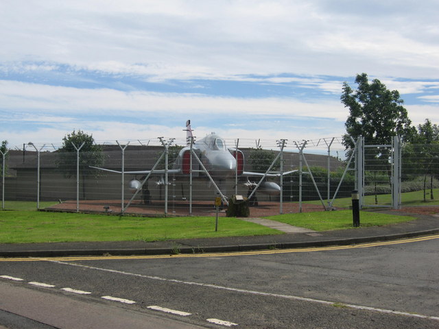
RAF Boulmer

Royal Air Force Boulmer or more simply RAF Boulmer is a Royal Air Force station near Alnwick in Northumberland, England, and is home to Aerospace Surveillance...
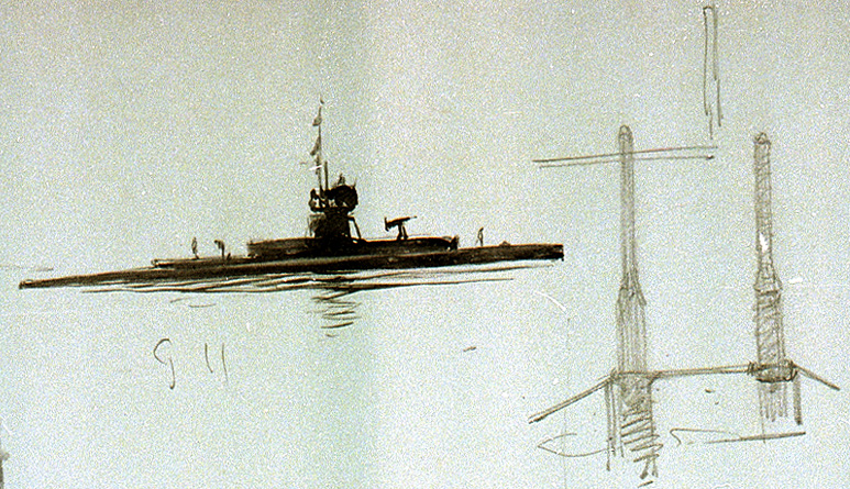
HMS G11

HMS G11 was a G-class submarine of the Royal Navy in service during the First World War. One of six of her class built by Vickers at Barrow in Furness...

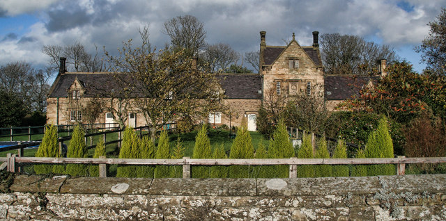
Howick, Northumberland

Howick ( HOH-ik) is a village and former civil parish, now in the parish of Longhoughton, in Northumberland, England, between Boulmer and Craster. It is...

Nearby Amenities

Located within 500m of 55.433463,-1.5752325
Created By: almien_coastlines
Lat/Long: 55.432415/-1.578684
Created By: almien_coastlines
Lat/Long: 55.432692/-1.580476
Created By: almien_coastlines
Lat/Long: 55.433225/-1.582259
Longhoughton Steel
Place: locality
Lat/Long: 55.4319921/-1.5733241
The data included in this document is from www.openstreetmap.org. The data is made available under ODbL.

Have you been to Longhoughton Steel?

Leave your review of Longhoughton Steel below (or comments, questions and feedback).