Engan Roo

Coastal Feature, Headland, Point in Shetland

Scotland

Engan Roo

South Harbour, Fair Isle
South Harbour, Fair Isle Credit: David Purchase

Engan Roo is a coastal feature located in the Shetland Islands, which are a part of Scotland. Specifically, Engan Roo is a headland or point that juts out into the North Sea on the east coast of the main island, known as Mainland. It is situated near the town of Lerwick, the capital of the Shetland Islands.

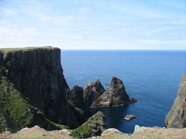
This headland is characterized by its rugged and rocky terrain, typical of the coastal landscape in the region. The cliffs of Engan Roo offer stunning views of the North Sea and are a popular spot for birdwatching enthusiasts as a variety of seabirds can be observed nesting and soaring above the waves.

The name "Engan Roo" likely originates from the Old Norse language, which was spoken by the Norse settlers who inhabited the Shetland Islands centuries ago. The word "Engan" translates to "narrow," which accurately describes the shape of the headland. "Roo" is believed to mean "rough" or "rugged," reflecting the challenging and untamed nature of the landscape.

Due to its picturesque location and natural beauty, Engan Roo attracts locals and tourists alike, who come to experience the dramatic coastal scenery and enjoy activities such as hiking, photography, and simply taking in the tranquility of the surroundings. The headland also serves as a landmark for sailors and fishermen navigating the waters off the coast of Shetland.

If you have any feedback on the listing, please let us know in the comments section below.

Engan Roo Images

Images are sourced within 2km of 59.524787/-1.6143314 or Grid Reference HZ2171. Thanks to Geograph Open Source API. All images are credited.

South Harbour, Fair Isle
View across South Harbour, with Tirricks Fair Isle's Tirricks (Arctic Terns) had a disastrous breeding season in 2008 - food to rear chicks was so scarce they didn't even try, we were told by an RSPB officer.
View across South Harbour, with Tirricks
Fair Isle's Tirricks (Arctic Terns) had a disastrous breeding season in 2008 - food to rear chicks was so scarce they didn't even try, we were told by an RSPB officer.
Fair Isle coastline at Port Saider A very detailed map of Fair Isle on view at the Fair Isle Bird Observatory marks Port Saider slightly to the north of the position on the 1:25,000 OS Map.  This view south-west towards the Burrian is from the cliff edge at the OS location.
Fair Isle coastline at Port Saider
A very detailed map of Fair Isle on view at the Fair Isle Bird Observatory marks Port Saider slightly to the north of the position on the 1:25,000 OS Map. This view south-west towards the Burrian is from the cliff edge at the OS location.
Cliff edge of Meo Ness The lichens on the rocks at the cliff edge provide a great contrast to the green of Meo Ness.  The South Light is visible beyond South Harbour.
Cliff edge of Meo Ness
The lichens on the rocks at the cliff edge provide a great contrast to the green of Meo Ness. The South Light is visible beyond South Harbour.
The Burrian The Burrian is the offshore skerry viewed across one of the many geos on Fair Isle.
The Burrian
The Burrian is the offshore skerry viewed across one of the many geos on Fair Isle.
Da Sherriff, Lunna Geo, Fair Isle The sea stack, da Sherriff, and Malcolm's Head beyond.
Da Sherriff, Lunna Geo, Fair Isle
The sea stack, da Sherriff, and Malcolm's Head beyond.
Coastline near Malcolm's Head A glorious clear day on Fair Isle with views over the crofting area.
Coastline near Malcolm's Head
A glorious clear day on Fair Isle with views over the crofting area.
Coastline from Malcolm's Head This is as near identical a viewpoint as I could find to <a href="https://www.geograph.org.uk/photo/871114">HZ1970 : Coastline near Malcolm's Head</a> which was taken in the summer of 1974. There are few differences to this view in 36 years, but they are significant for the island.  First, the wind turbine constructed in 1982 is evident - sadly in July 2010 it was not operating and needing repair.  Second, a community hall has been built beside the school - in the picture these are the nearest visible buildings to Sheep Rock. It is difficult to assess how much the coastline has eroded in the 36 years.
Coastline from Malcolm's Head
This is as near identical a viewpoint as I could find to HZ1970 : Coastline near Malcolm's Head which was taken in the summer of 1974. There are few differences to this view in 36 years, but they are significant for the island. First, the wind turbine constructed in 1982 is evident - sadly in July 2010 it was not operating and needing repair. Second, a community hall has been built beside the school - in the picture these are the nearest visible buildings to Sheep Rock. It is difficult to assess how much the coastline has eroded in the 36 years.
The Burrian from Busta Geo, Fair Isle
Cliffs at Hoini, Fair Isle
The middle of the Fair Isle landing strip Flight DFL002 for Tingwall had just departed, and the next flight wasn't due to arrive for about six hours. So it was deemed quite safe for me to cross the strip on my way to the track to Ward Hill.

Amusingly, when that next flight arrived, the landing was aborted at the last minute, and the pilot went round for another attempt. The reason? There was a sheep on the strip!

The trip reminded me of my visit to the Isles of Scilly, at the other end of the country, in 2013. Similar small and rather noisy planes, and a runway (in <a href="https://www.geograph.org.uk/gridref/SV9110">SV9110</a>) on a convex slope so that the pilots couldn't see that far ahead.
The middle of the Fair Isle landing strip
Flight DFL002 for Tingwall had just departed, and the next flight wasn't due to arrive for about six hours. So it was deemed quite safe for me to cross the strip on my way to the track to Ward Hill. Amusingly, when that next flight arrived, the landing was aborted at the last minute, and the pilot went round for another attempt. The reason? There was a sheep on the strip! The trip reminded me of my visit to the Isles of Scilly, at the other end of the country, in 2013. Similar small and rather noisy planes, and a runway (in SV9110) on a convex slope so that the pilots couldn't see that far ahead.
Burrashield Hill Although one can argue about "What is a hill?", I think there are five hills of any significance on Fair Isle. At 150m, Burrashield Hill is clearly the second highest, after Ward Hill, in <a href="https://www.geograph.org.uk/gridref/HZ2073">HZ2073</a>.
Burrashield Hill
Although one can argue about "What is a hill?", I think there are five hills of any significance on Fair Isle. At 150m, Burrashield Hill is clearly the second highest, after Ward Hill, in HZ2073.
Vaasetter Hill, Fair Isle Vaasetter Hill, 110m, is the rounded light-coloured hill straight ahead. It is a very easy walk, though unfortunately I did not have time to climb it. Beyond Vaasetter Hill looms the dark summit of Sheep Rock (132m, and still just in square). Sheep Rock is accessible only to climbers capable at a high grade.

It may not be very long before Sheep Rock becomes a separate island, as the link is very narrow and fragile. This won't make it any more difficult to climb, as the only practicable route is from the east.

Although one can argue about "What is a hill?", I think there are five hills of any significance on Fair Isle. On this basis, Sheep Rock is the third highest and Vaasetter the fourth.
Vaasetter Hill, Fair Isle
Vaasetter Hill, 110m, is the rounded light-coloured hill straight ahead. It is a very easy walk, though unfortunately I did not have time to climb it. Beyond Vaasetter Hill looms the dark summit of Sheep Rock (132m, and still just in square). Sheep Rock is accessible only to climbers capable at a high grade. It may not be very long before Sheep Rock becomes a separate island, as the link is very narrow and fragile. This won't make it any more difficult to climb, as the only practicable route is from the east. Although one can argue about "What is a hill?", I think there are five hills of any significance on Fair Isle. On this basis, Sheep Rock is the third highest and Vaasetter the fourth.
Stonybreck, Fair Isle Malcolm's Head, 107m, beyond.
Stonybreck, Fair Isle
Malcolm's Head, 107m, beyond.
The gorge of Gilsetter Burn Falling to the east coast of Fair Isle, with South Gavel on Bu Ness beyond. It had been dry for some weeks, so there was almost no water in the burn.
The gorge of Gilsetter Burn
Falling to the east coast of Fair Isle, with South Gavel on Bu Ness beyond. It had been dry for some weeks, so there was almost no water in the burn.
Fair Isle from the air Taken from a plane en route between Sumburgh and Aberdeen. The closest part of the island is Buness.
Fair Isle from the air
Taken from a plane en route between Sumburgh and Aberdeen. The closest part of the island is Buness.
Evening at North Haven, Fair Isle Even the bonxie looked relaxed, but watchful.

Fair Isle experiences extremely strong winds and even heavy wooden rowing boats have to be securely tied down.
Evening at North Haven, Fair Isle
Even the bonxie looked relaxed, but watchful. Fair Isle experiences extremely strong winds and even heavy wooden rowing boats have to be securely tied down.
Mavers Geo, South Haven, Fair Isle
Show me another place!

Engan Roo is located at Grid Ref: HZ2171 (Lat: 59.524787, Lng: -1.6143314)

Unitary Authority: Shetland Islands

Police Authority: Highlands and Islands

What 3 Words

///publisher.gearbox.scrum. Near Sumburgh, Shetland Islands

Related Wikis

Stroms Hellier

Stroms Hellier (Stroms Heelor) is a steep-sided rocky cove located off the Swartz Geo inlet on Fair Isle in the Scottish Shetland Islands.On 27 September...

El Gran Grifón

El Gran Grifón was the flagship of the Spanish Armada's supply squadron of Baltic hulks (built in and chartered from the City of Rostock, in modern-day...

Fair Isle Airport

Fair Isle Airport (IATA: FIE, ICAO: EGEF), is a small airport located in Fair Isle, Shetland, Scotland. It is owned by the National Trust for Scotland...

North Haven (harbour)

North Haven is a natural cove, developed in the 20th century as one of the primary ports of Fair Isle, an outlying island of the Shetland Isles in the...

Nearby Amenities

Located within 500m of 59.524787,-1.6143314
Sheep rock
Place: locality
Lat/Long: 59.5246231/-1.6115794
Vaasetter
Place: locality
Lat/Long: 59.5265815/-1.6179088
The data included in this document is from www.openstreetmap.org. The data is made available under ODbL.

Have you been to Engan Roo?

Leave your review of Engan Roo below (or comments, questions and feedback).