The Kiln

Coastal Feature, Headland, Point in Shetland

Scotland

The Kiln

Fogla Skerry and Lyra Stack, Papa Stour, from Huxter, Sandness
Fogla Skerry and Lyra Stack, Papa Stour, from Huxter, Sandness Credit: Mike Pennington

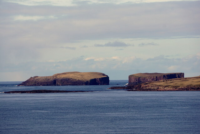
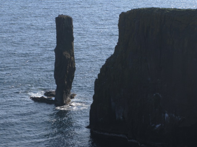
The Kiln is a prominent coastal feature located in the Shetland Islands, an archipelago in Scotland. Situated on the mainland, it is specifically found on the east coast of the South Mainland. The Kiln is a headland that extends into the North Sea, forming a distinctive point that is easily recognizable.

This coastal feature derives its name from the kiln-like shape that it exhibits, resembling an old-fashioned pottery kiln. The point is characterized by steep cliffs that rise abruptly from the sea, creating a dramatic and imposing landscape. These cliffs are composed of rugged rock formations, mainly consisting of sandstone and shale. The color palette of the rocks varies from shades of gray to brown, adding to the visual appeal of The Kiln.

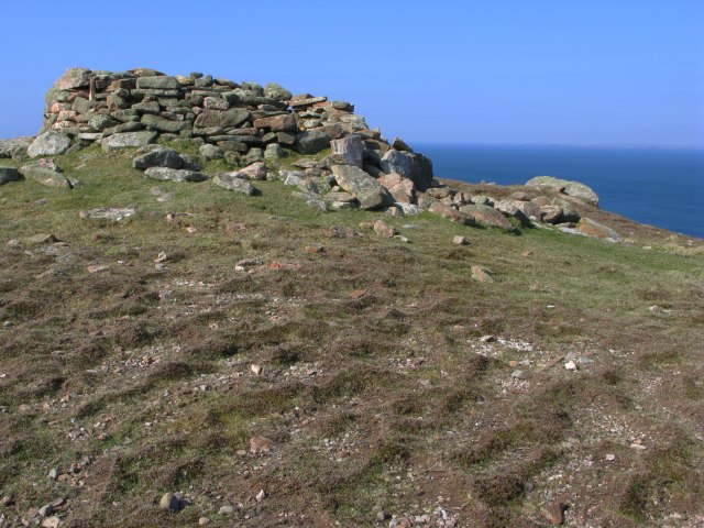
The location of The Kiln makes it an ideal spot for coastal activities such as birdwatching and fishing. The cliffs provide nesting sites for seabirds such as fulmars, kittiwakes, and guillemots, making it a popular destination for bird enthusiasts. The surrounding waters are also known for their abundance of fish, attracting anglers who seek a rewarding catch.

The Kiln is easily accessible via a well-maintained footpath that leads to the headland. This path offers stunning views of the surrounding coastline and can be enjoyed by both casual walkers and experienced hikers. The area is also home to a diverse range of flora and fauna, with wildflowers and grasses dotting the landscape.

Overall, The Kiln is a captivating coastal feature that showcases the rugged beauty of the Shetland Islands. Its unique shape, impressive cliffs, and diverse wildlife make it a must-visit destination for nature enthusiasts and those seeking a tranquil coastal experience.

If you have any feedback on the listing, please let us know in the comments section below.

The Kiln Images

Images are sourced within 2km of 60.345233/-1.7181068 or Grid Reference HU1562. Thanks to Geograph Open Source API. All images are credited.

Fogla Skerry and Lyra Stack, Papa Stour, from Huxter, Sandness
Aesha Head One of the many fine stretches of coast on Papa Stours, Aesha Head is the furthest west point of the main island, though there are various smaller islands and skerries beyond.
Aesha Head
One of the many fine stretches of coast on Papa Stours, Aesha Head is the furthest west point of the main island, though there are various smaller islands and skerries beyond.
Natural Arch, Aesha Head This is a closer view of the fine arch in Aesha Head, with a glimpse of Lyra Skerry beyond.
Natural Arch, Aesha Head
This is a closer view of the fine arch in Aesha Head, with a glimpse of Lyra Skerry beyond.
Kirstan's Hole Actually, it isn't the Kirstan's Hole (or Christie's Hole) shown on the maps, but a second hole which opened suddenly a few years ago, where previously there had been a depression in the ground, into the same sea-cave system as the original Kirstan's Hole.
Kirstan's Hole
Actually, it isn't the Kirstan's Hole (or Christie's Hole) shown on the maps, but a second hole which opened suddenly a few years ago, where previously there had been a depression in the ground, into the same sea-cave system as the original Kirstan's Hole.
Storm Beach These boulders, thrown up by the waves to form a storm beach 30 metres above the sea, demonstrate the power of the seas which pound the exposed north side of Papa Stour
Storm Beach
These boulders, thrown up by the waves to form a storm beach 30 metres above the sea, demonstrate the power of the seas which pound the exposed north side of Papa Stour
Ruined Meal Mills Several traditional mills straddle this little burn. Inside the building was a fixed lower millstone, and a rotating upper millstone driven by the water falling on to the paddles below, which were mounted at 45º to the vertical drive shaft.
Ruined Meal Mills
Several traditional mills straddle this little burn. Inside the building was a fixed lower millstone, and a rotating upper millstone driven by the water falling on to the paddles below, which were mounted at 45º to the vertical drive shaft.
The Loch that Ebbs and Flows The interior of Papa Stour is mainly moorland, though there are several lochans in the central part. This one's curious name reflects its closeness to the sea, from which it is cut off only by an ayre or shingle spit.
The Loch that Ebbs and Flows
The interior of Papa Stour is mainly moorland, though there are several lochans in the central part. This one's curious name reflects its closeness to the sea, from which it is cut off only by an ayre or shingle spit.
Lang Geo One of the many inlets typical of the north coast of Papa Stour.
Lang Geo
One of the many inlets typical of the north coast of Papa Stour.
Remains of Observation Post The concrete and iron are the only remains of a World War Two observation post that used to stand here.  As can be seen from the image, in good visibility this location provides an excellent view of the surrounding area.
Remains of Observation Post
The concrete and iron are the only remains of a World War Two observation post that used to stand here. As can be seen from the image, in good visibility this location provides an excellent view of the surrounding area.
Natural Arch by Sholma Wick The map marks this as a Natural Arch - one of many arches, subterranean passages or caves to be found on the island.
Natural Arch by Sholma Wick
The map marks this as a Natural Arch - one of many arches, subterranean passages or caves to be found on the island.
Plastic beach The beach had a depressingly large amount of plastic waste which had been washed up onto it.  This largely comprised plastic bottles , footwear, floats/buoys etc.

Most identifyable items originated in the UK, but a large subset were from Spain, Norway and Iceland.  This latter set probably represents the boats fishing in these waters and the manufacturers supplying those boats.
Plastic beach
The beach had a depressingly large amount of plastic waste which had been washed up onto it. This largely comprised plastic bottles , footwear, floats/buoys etc. Most identifyable items originated in the UK, but a large subset were from Spain, Norway and Iceland. This latter set probably represents the boats fishing in these waters and the manufacturers supplying those boats.
Plastic Beach A further selection of the plastic contamination in this area.
Plastic Beach
A further selection of the plastic contamination in this area.
Snolda Sea Stack
Snolda Sea Stack
Lyra Stack Lyra Stack lies just to the south of Lyra Skerry which is the land in the right half of this image.
Lyra Stack
Lyra Stack lies just to the south of Lyra Skerry which is the land in the right half of this image.
Ruined meal mill The image shows the rear of one of the two mills at this location.  The image was taken from channel, now waterless, which fed water into the mill.
Ruined meal mill
The image shows the rear of one of the two mills at this location. The image was taken from channel, now waterless, which fed water into the mill.
Ruined mill The image shows a view of the front of the mill shown in <a href="https://www.geograph.org.uk/photo/799075">HU1660 : Ruined meal mill</a>.
Ruined mill
The image shows a view of the front of the mill shown in HU1660 : Ruined meal mill.
Summit shelter The well constructed circular stone wall surrounds the triangulation pillar at the highest point on Papa Stour.  The wall provides excellent shelter from the inevitable Atlantic winds.
Summit shelter
The well constructed circular stone wall surrounds the triangulation pillar at the highest point on Papa Stour. The wall provides excellent shelter from the inevitable Atlantic winds.
Ruined mill complete with stream This side of the island has many disused mills, all situated on the outflows of the few sizeable lochans found here.  This mill, unique amongst those that I observed, still has some water running through it - all others appear to have had the channels blocked off at some point.

It should be noted that most of the usable arable land is/was on the other side of the island.  The mills have been located on this northwest side of the island presumably to be close to the supplies of water.
Ruined mill complete with stream
This side of the island has many disused mills, all situated on the outflows of the few sizeable lochans found here. This mill, unique amongst those that I observed, still has some water running through it - all others appear to have had the channels blocked off at some point. It should be noted that most of the usable arable land is/was on the other side of the island. The mills have been located on this northwest side of the island presumably to be close to the supplies of water.
Show me another place!

The Kiln is located at Grid Ref: HU1562 (Lat: 60.345233, Lng: -1.7181068)

Unitary Authority: Shetland Islands

Police Authority: Highlands and Islands

What 3 Words

///recording.remarking.sofa. Near Walls, Shetland Islands

Related Wikis

Papa Stour

Papa Stour (Scots: Papa Stour) is one of the Shetland Islands in Scotland, with a population of under fifteen people, some of whom immigrated after an...

Biggings

Biggings is a village on the island of Papa Stour, in Shetland, Scotland. Papa Stour's church is situated at the south of Biggings. A homestead of Duke...

Papa Stour Airstrip

Papa Stour Airstrip is a small airstrip in the village of Biggings on the island of Papa Stour. Shetland, Scotland. == History == Papa Stour Airstrip opened...
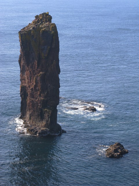
Maiden Stack

The Maiden Stack or Frau Stack is a tiny stack in the western Shetland Islands to the north of Brei Holm and east of Housa Voe in Papa Stour. It is so...

Have you been to The Kiln?

Leave your review of The Kiln below (or comments, questions and feedback).