Mill Stone Neuk

Coastal Feature, Headland, Point in East Lothian

Scotland

Mill Stone Neuk

Dunbar Cement Works
Dunbar Cement Works Credit: John Darcy

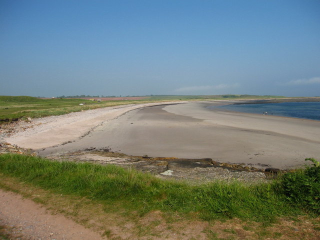
Mill Stone Neuk is a prominent coastal feature located in East Lothian, Scotland. Situated on the southeastern coast of the country, it is specifically identified as a headland or point due to its distinct geographical characteristics.

The name "Mill Stone Neuk" is derived from the presence of an ancient millstone that can be found in the area. This historical artifact adds to the allure and cultural significance of the site.

The headland itself is made up of rugged cliffs and rocky outcrops that stretch out into the North Sea. Its elevated position provides stunning panoramic views of the surrounding coastline and the vast expanse of the sea. The headland is also known for its diverse wildlife, including seabirds such as gannets, puffins, and kittiwakes, which nest on the cliffs.

Mill Stone Neuk is a popular destination for locals and tourists alike, offering a range of recreational activities. Visitors can enjoy cliff-top walks along well-maintained paths, taking in the breathtaking scenery and soaking up the fresh sea air. The area is also a haven for birdwatchers and nature enthusiasts, who can observe the various species of birds and marine life that inhabit the region.

Additionally, Mill Stone Neuk boasts a rich history, with archaeological remains dating back to prehistoric times. The site has also witnessed significant maritime activity over the centuries, including shipwrecks and fishing traditions that have shaped the local culture.

Overall, Mill Stone Neuk is a captivating headland on the East Lothian coast, offering a perfect blend of natural beauty, historical significance, and recreational opportunities.

If you have any feedback on the listing, please let us know in the comments section below.

Mill Stone Neuk Images

Images are sourced within 2km of 55.993906/-2.4686252 or Grid Reference NT7077. Thanks to Geograph Open Source API. All images are credited.

Dunbar Cement Works
Dunbar Cement Works
Quarry, Dunbar cement works. The Lothians have a fair bit of limestone, a rock notable in Scotland by its relative scarcity.  Near Barns Ness there are sufficient quantities to feed a cement works.  The works are next door, but most of NT7077 is taken up by this vast, if not deep quarry.
Quarry, Dunbar cement works.
The Lothians have a fair bit of limestone, a rock notable in Scotland by its relative scarcity. Near Barns Ness there are sufficient quantities to feed a cement works. The works are next door, but most of NT7077 is taken up by this vast, if not deep quarry.
White Sands Behind the uglyness of the limestone quarries are a series of lovely beaches. As well as the white sands, there are limestone slabs here, backed by land used previously for quarrying and a strip of very attractive links. Its managed as a country park.
White Sands
Behind the uglyness of the limestone quarries are a series of lovely beaches. As well as the white sands, there are limestone slabs here, backed by land used previously for quarrying and a strip of very attractive links. Its managed as a country park.
Barns Ness lighthouse Built 1901
Barns Ness lighthouse
Built 1901
Cement works at night
Farm Track at East Barns, near Dunbar View over farmland towards Barns Ness Lighthouse.
Farm Track at East Barns, near Dunbar
View over farmland towards Barns Ness Lighthouse.
Lawrie's Den Rock formations at Lawrie's Den on the Firth of Forth Estuary. Here the John Muir Way passes through Dunbar Golf Course <a href="https://www.geograph.org.uk/photo/146845">NT6978 : Dunbar Golf Course</a>.
Lawrie's Den
Rock formations at Lawrie's Den on the Firth of Forth Estuary. Here the John Muir Way passes through Dunbar Golf Course NT6978 : Dunbar Golf Course.
Broxmouth Park Observatory, near Dunbar Observatory (circa 1850), also known as Sloe Bigging lookout tower. Single storey octagonal room with adjoining 2-storey tower. Dunbar Cement Works visible in background. In the foreground is the wall to the Deer Park that runs the length of Dunbar Golf Course.
Broxmouth Park Observatory, near Dunbar
Observatory (circa 1850), also known as Sloe Bigging lookout tower. Single storey octagonal room with adjoining 2-storey tower. Dunbar Cement Works visible in background. In the foreground is the wall to the Deer Park that runs the length of Dunbar Golf Course.
Mill Stone Neuk Peninsula of rocks protruding into the Firth of Forth at Whitesands.
Mill Stone Neuk
Peninsula of rocks protruding into the Firth of Forth at Whitesands.
Catcraig Limekilns The area around Dunbar was very important in the 18th and 19th centuries for making lime for spreading on the fields. Most was sent by cart to Berwickshire. These are a pair of mid 19th century kilns, one a 2-draw kiln, the other a 3-draw kiln. The kilns were associated with quarries, a power-house, and a track leading to a landing-place on the rocks and were closed in 1921, during the miners strike.
Catcraig Limekilns
The area around Dunbar was very important in the 18th and 19th centuries for making lime for spreading on the fields. Most was sent by cart to Berwickshire. These are a pair of mid 19th century kilns, one a 2-draw kiln, the other a 3-draw kiln. The kilns were associated with quarries, a power-house, and a track leading to a landing-place on the rocks and were closed in 1921, during the miners strike.
Red Hot Pokers Kniphofia uvaria in the dunes at Whitesands.
Red Hot Pokers
Kniphofia uvaria in the dunes at Whitesands.
White Sands View northwest towards Dunbar.
White Sands
View northwest towards Dunbar.
Water Tap Two of these at White Sands Beach, near Dunbar.
Water Tap
Two of these at White Sands Beach, near Dunbar.
Take a Rest Interesting seating on the John Muir Way at White Sands beach.
Take a Rest
Interesting seating on the John Muir Way at White Sands beach.
Ruined Building on Dunbar Golf Course Now marked on map as a sheepfold, shown on map of 1854 as a house.
Ruined Building on Dunbar Golf Course
Now marked on map as a sheepfold, shown on map of 1854 as a house.
White Sands The John Muir Way passes along the edge of Dunbar Golf Course and then along White Sands Beach.
White Sands
The John Muir Way passes along the edge of Dunbar Golf Course and then along White Sands Beach.
Mill Stone Neuk An area of rocks lying between high and low water marks a short distance N of White Sands. A coarse kind of mill stone was formerly obtained here, hence the name.
Mill Stone Neuk
An area of rocks lying between high and low water marks a short distance N of White Sands. A coarse kind of mill stone was formerly obtained here, hence the name.
Show me another place!

Mill Stone Neuk is located at Grid Ref: NT7077 (Lat: 55.993906, Lng: -2.4686252)

Unitary Authority: East Lothian

Police Authority: The Lothians and Scottish Borders

What 3 Words

///unlucky.helpful.simulator. Near Dunbar, East Lothian

Nearby Locations

Mill Stone Neuk

Related Wikis

Battle of Dunbar (1650)

The Battle of Dunbar was fought between the English New Model Army, under Oliver Cromwell, and a Scottish army commanded by David Leslie on 3 September...

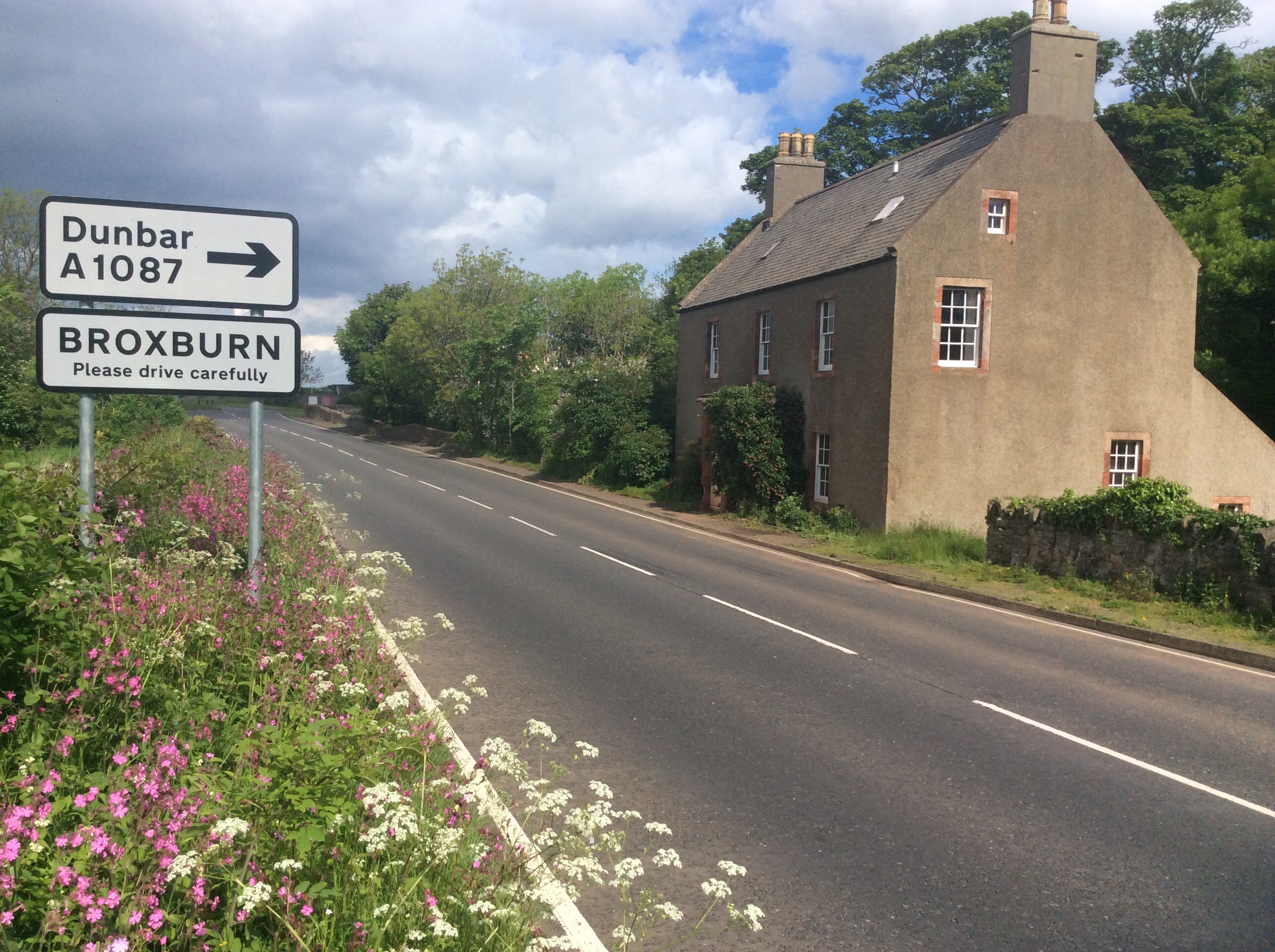
Broxburn, East Lothian

Broxburn is a hamlet consisting of a handful of scattered houses which serve the Broxmouth estate in East Lothian, Scotland. It is named after the stream...

Barns Ness Lighthouse

Barns Ness Lighthouse is 3.1 miles (5 km) from Dunbar and was constructed by the engineers and brothers David A. Stevenson and Charles Alexander Stevenson...
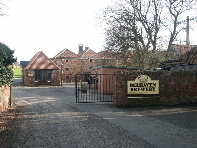
Belhaven Brewery

Belhaven Brewery is a brewery based in Belhaven, Scotland. The brewery dates from 1719, at least; by 2005 it had become the largest and oldest surviving...

Nearby Amenities

Located within 500m of 55.993906,-2.4686252
Passing Place
Lat/Long: 55.9912216/-2.4737251
Golf: pin
Lat/Long: 55.9929076/-2.4731975
Golf: pin
Lat/Long: 55.9954077/-2.4740908
Golf: pin
Lat/Long: 55.9923924/-2.471862
Golf: pin
Lat/Long: 55.990813/-2.4716127
Golf: pin
Lat/Long: 55.9936649/-2.4754375
The data included in this document is from www.openstreetmap.org. The data is made available under ODbL.

Have you been to Mill Stone Neuk?

Leave your review of Mill Stone Neuk below (or comments, questions and feedback).