Cullya Blet
Coastal Feature, Headland, Point in Orkney
Scotland
Cullya Blet
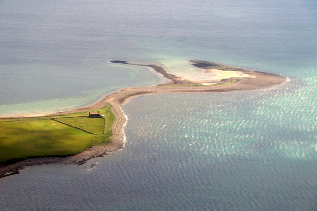
Cullya Blet is a prominent coastal feature located on the northeastern coast of Orkney, an archipelago in northern Scotland. It is a headland characterized by its rugged cliffs and rocky terrain, jutting out into the North Sea. The name "Cullya Blet" is derived from the Orcadian dialect, with "Cullya" referring to a small hill or knoll and "Blet" meaning a cliff or precipice.
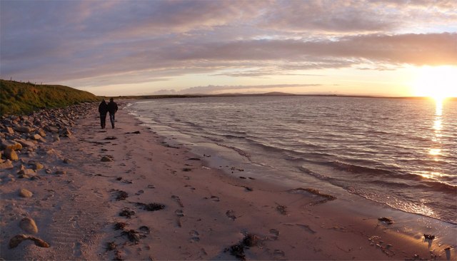
The headland offers breathtaking views of the surrounding coastline, with its towering cliffs providing a nesting site for various seabirds, including guillemots, puffins, and kittiwakes. This makes Cullya Blet a popular destination for birdwatchers and nature enthusiasts.
The rocky shores and hidden coves around Cullya Blet are also home to a diverse range of marine life, including seals, dolphins, and even occasional sightings of whales. The area is known for its rich biodiversity, with various plant species thriving in the coastal habitat.
Cullya Blet is accessible by foot, and there are several walking trails that lead to the headland, allowing visitors to explore the stunning coastal landscape and observe the wildlife in its natural habitat. The headland also provides a vantage point for panoramic views of the surrounding sea and nearby islands.
Overall, Cullya Blet is a remarkable coastal feature in Orkney, offering a blend of natural beauty, wildlife diversity, and stunning vistas that attract both locals and tourists alike.
If you have any feedback on the listing, please let us know in the comments section below.
Cullya Blet Images
Images are sourced within 2km of 58.951022/-2.7809495 or Grid Reference HY5507. Thanks to Geograph Open Source API. All images are credited.


Cullya Blet is located at Grid Ref: HY5507 (Lat: 58.951022, Lng: -2.7809495)
Unitary Authority: Orkney Islands
Police Authority: Highlands and Islands
What 3 Words
///earlobes.hounded.fleet. Near Deerness, Orkney Islands
Nearby Locations
Related Wikis

Deerness
Deerness (, locally , Old Norse: Dyrnes) is a quoad sacra parish (i.e. one created and functioning for ecclesiastical purposes only) and peninsula in Mainland...

St Peter's Pool, Orkney
St Peter's Pool is a bay in the East Mainland of Orkney, Scotland. This bay was the site of significant coastal defences during World War II, when a German...

Tankerness
Tankerness is a district in the St Andrews parish in Mainland, Orkney, Scotland. Essentially a peninsula, it is about 13 kilometres (8 mi) south-east of...

The Gloup
The Gloup () is a collapsed sea cave in the Mull Head Nature Reserve in the islands of Orkney, Scotland. The name derives from the Old Norse "gluppa",...

Loch of Tankerness
Loch of Tankerness is a large, lowland, freshwater loch on the Orkney mainland in Scotland. The loch is roughly triangular in shape and is shallow with...

Toab, Orkney
Toab is a parish on the Orkney Mainland, situated in the East Mainland. Toab is located off the A960 road at the head of Deer Sound on the Mainland, Orkney...
Mine Howe
Mine Howe is an Iron Age subterranean man-made chamber dug 6 meters (20 feet) deep inside a large mound. It is located in the Tankerness area of Orkney...
St Andrews, Orkney
St Andrews is a parish on Mainland, Orkney in Scotland. It is located east of the town of Kirkwall and the parish of St Ola and lies north of Holm and...
Nearby Amenities
Located within 500m of 58.951022,-2.7809495Have you been to Cullya Blet?
Leave your review of Cullya Blet below (or comments, questions and feedback).