Cow's Hole

Coastal Feature, Headland, Point in Fife

Scotland

Cow's Hole

Wormit From the Tay Rail Bridge.
Wormit Credit: JThomas

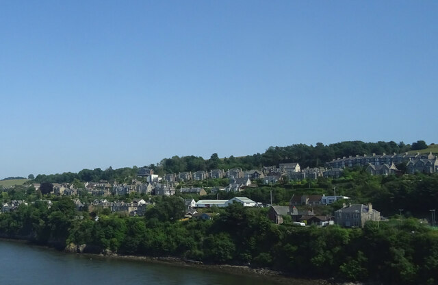
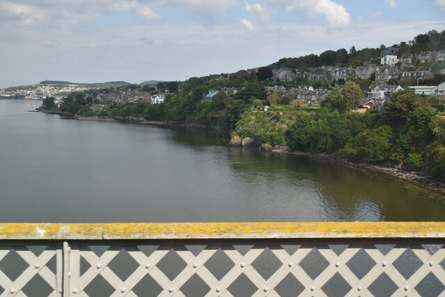
Cow's Hole is a coastal feature located in Fife, Scotland. It is a picturesque headland that juts out into the North Sea, forming a prominent point along the coastline. The name "Cow's Hole" is derived from a small natural cave or hole found in the cliffs of the headland, which is said to resemble the shape of a cow's head.

This coastal feature is known for its rugged beauty and stunning views. The headland is composed of towering cliffs made of sandstone and shale, which have been shaped over thousands of years by the relentless pounding of waves. The cliffs rise to an impressive height, providing an excellent vantage point to observe the surrounding seascape.

The area around Cow's Hole is rich in biodiversity and supports a variety of marine and bird life. Seabirds like gulls, puffins, and razorbills can often be spotted nesting on the cliffs, while seals and dolphins occasionally visit the waters below.

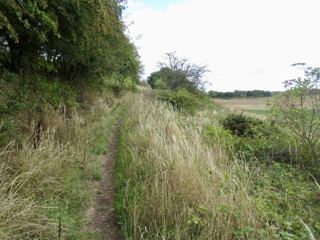
Visitors to Cow's Hole can enjoy a range of activities, including hiking along the coastal path that runs along the cliff tops, offering stunning panoramic views of the sea and the surrounding coastline. The area also provides opportunities for birdwatching, photography, and exploring the cave itself, although caution is advised due to the steep and unstable nature of the cliffs.

Overall, Cow's Hole is a captivating coastal feature in Fife, offering visitors a unique blend of natural beauty, wildlife, and recreational opportunities. Its dramatic cliffs and enchanting cave make it a must-see destination for nature enthusiasts and those seeking a peaceful retreat along the Scottish coast.

If you have any feedback on the listing, please let us know in the comments section below.

Cow's Hole Images

Images are sourced within 2km of 56.432128/-2.9584702 or Grid Reference NO4027. Thanks to Geograph Open Source API. All images are credited.

Wormit From the Tay Rail Bridge.
Wormit
From the Tay Rail Bridge.
New housing development, Wormit
River Tay from Tay Rail Bridge
River Tay from the Tay Rail Bridge, Wormit
Old lorry above Wormit
Path over Wormit Hill Mapped as a road, it is actually an enjoyable path.
Path over Wormit Hill
Mapped as a road, it is actually an enjoyable path.
Path over Wormit Hill Mapped as a road, it is actually an enjoyable path.
Path over Wormit Hill
Mapped as a road, it is actually an enjoyable path.
Tay Bridge and Dundee View off Newton Hill.
Tay Bridge and Dundee
View off Newton Hill.
From the Tay Bridge The view of the river, looking towards Dundee just before the train enters the central span of the bridge.
From the Tay Bridge
The view of the river, looking towards Dundee just before the train enters the central span of the bridge.
Waste ground, Wormit
Tay Bridge South Signalbox Signalboxes are used in Britain to control the safe movement of trains across the railway network. Most are located either just outside stations or at junctions.
Wikipedia: <span class="nowrap"><a title="http://en.wikipedia.org/wiki/Signalling_control" rel="nofollow ugc noopener" href="http://en.wikipedia.org/wiki/Signalling_control">Link</a><img style="margin-left:2px;" alt="External link" title="External link - shift click to open in new window" src="https://s1.geograph.org.uk/img/external.png" width="10" height="10"/></span>
Tay Bridge South Signalbox
Signalboxes are used in Britain to control the safe movement of trains across the railway network. Most are located either just outside stations or at junctions. Wikipedia: LinkExternal link
South shore of the Tay Estuary The River Tay is the longest river in Scotland and the seventh-longest in the United Kingdom. The Tay originates in western Scotland on the slopes of Ben Lui, then flows easterly across the Highlands, through Loch Dochart, Loch Iubhair and Loch Tay, then continues east through Strathtay, in the centre of Scotland, then southeasterly through Perth, where it becomes tidal, to its mouth at the Firth of Tay, south of Dundee. It is the largest river in the UK by measured discharge. Its catchment is approximately 2,000 square miles.
South shore of the Tay Estuary
The River Tay is the longest river in Scotland and the seventh-longest in the United Kingdom. The Tay originates in western Scotland on the slopes of Ben Lui, then flows easterly across the Highlands, through Loch Dochart, Loch Iubhair and Loch Tay, then continues east through Strathtay, in the centre of Scotland, then southeasterly through Perth, where it becomes tidal, to its mouth at the Firth of Tay, south of Dundee. It is the largest river in the UK by measured discharge. Its catchment is approximately 2,000 square miles.
Tay Estuary The River Tay is the longest river in Scotland and the seventh-longest in the United Kingdom. The Tay originates in western Scotland on the slopes of Ben Lui, then flows easterly across the Highlands, through Loch Dochart, Loch Iubhair and Loch Tay, then continues east through Strathtay, in the centre of Scotland, then southeasterly through Perth, where it becomes tidal, to its mouth at the Firth of Tay, south of Dundee. It is the largest river in the UK by measured discharge. Its catchment is approximately 2,000 square miles.
Tay Estuary
The River Tay is the longest river in Scotland and the seventh-longest in the United Kingdom. The Tay originates in western Scotland on the slopes of Ben Lui, then flows easterly across the Highlands, through Loch Dochart, Loch Iubhair and Loch Tay, then continues east through Strathtay, in the centre of Scotland, then southeasterly through Perth, where it becomes tidal, to its mouth at the Firth of Tay, south of Dundee. It is the largest river in the UK by measured discharge. Its catchment is approximately 2,000 square miles.
The Silvery Tay The Tay Bridge from Dundee Law.
The Silvery Tay
The Tay Bridge from Dundee Law.
Tay Railway Bridge from Wormit towards Dundee
Tay Bridge, 1988 The railway bridge across the Firth of Tay in the summer of 1988
Tay Bridge, 1988
The railway bridge across the Firth of Tay in the summer of 1988
Masonic Lodge, Wormit, Fife Lodge Tay Union No.273, Wormit, Fife
Masonic Lodge, Wormit, Fife
Lodge Tay Union No.273, Wormit, Fife
Tay Bridge from the "Queen" - a pleasure boat running in 1981
Show me another place!

Cow's Hole is located at Grid Ref: NO4027 (Lat: 56.432128, Lng: -2.9584702)

Unitary Authority: Fife

Police Authority: Fife

What 3 Words

///greeting.styled.warms. Near Newport-on-Tay, Fife

Nearby Locations

Cow's Hole

Related Wikis

Woodhaven, Fife

Woodhaven used to be a small village between Newport-on-Tay and Wormit in Fife, Scotland. Due to expansion of these two villages over the years, it is...

Newport-on-Tay West railway station

Newport-on-Tay West railway station served the town of Newport-on-Tay, Fife, Scotland, from 1879 to 1969 on the Newport Railway. == History == The station...

Newport-on-Tay

Newport-on-Tay is a small town in the north-east of Fife in Scotland, acting as a commuter town for Dundee. The Fife Coastal Path passes through Newport...

Wormit

Wormit is a village on the south shore of the Firth of Tay in north-east Fife, Scotland. Its location at the southern end of the Tay Rail Bridge has led...

Wormit railway station

Wormit railway station served the town of Wormit, Fife, Scotland from 1889 to 1969 on the Newport Railway. == History == The station opened on 1 May 1889...

Newport-on-Tay East railway station

Newport-on-Tay East railway station formerly served the town of Newport-on-Tay, Fife, Scotland. The station closed in 1969. == Tayport branch == Newport...

Forgan (Fife)

Forgan is a civil parish in the Scottish county of Fife. It extends 4 miles in length along the north coast of Fife and is at the southern mouth of the...

Radio Tay

Radio Tay is a group of two Independent Local Radio stations serving Tayside and northeast Fife in Scotland. Radio Tay is owned and operated by Bauer Radio...

Nearby Amenities

Located within 500m of 56.432128,-2.9584702
Recycling
Lat/Long: 56.4321185/-2.9533118
Turning Circle
Lat/Long: 56.4304387/-2.9645533
Woodhaven
Place: suburb
Source: OS_OpenData_StreetView
Lat/Long: 56.4308297/-2.9609167
Leisure: slipway
Lat/Long: 56.4313729/-2.9621291
Leisure: slipway
Lat/Long: 56.431876/-2.9623858
Addr City: Wormit
Addr Housenumber: 1
Addr Street: St Fort Place
Lat/Long: 56.4308668/-2.9613471
Addr City: Wormit
Addr Housenumber: 2
Addr Street: St Fort Place
Lat/Long: 56.4308268/-2.9615702
Addr City: Wormit
Addr Housenumber: 3
Addr Street: St Fort Place
Lat/Long: 56.4307439/-2.9619
Addr City: Wormit
Addr Housenumber: 4
Addr Street: St Fort Place
Lat/Long: 56.4306987/-2.9621661
Addr City: Wormit
Addr Housenumber: 5
Addr Street: St Fort Place
Lat/Long: 56.4306491/-2.9624401
Addr City: Wormit
Addr Housenumber: 6
Addr Street: St Fort Place
Lat/Long: 56.430603/-2.9627596
Addr Housenumber: 90
Addr Street: West Road
Lat/Long: 56.4331669/-2.9548905
Post Box
Collection Times: Mo-Fr 09:00; Sa 07:00
Operator: Royal Mail
Post Box Type: wall
Ref: DD6 180D
Royal Cypher: GR
Royal Cypher Wikidata: Q33102273
Lat/Long: 56.4307056/-2.9629449
Historic: memorial
Lat/Long: 56.4311675/-2.9626736
Bus Stop
Bench: yes
Shelter: no
Lat/Long: 56.4323442/-2.9570139
Bus Stop
Bench: yes
Shelter: yes
Lat/Long: 56.4325913/-2.9565804
Addr City: Wormit
Addr Housenumber: 47
Addr Street: West Road
Lat/Long: 56.4334907/-2.952932
Bus Stop
Bench: no
Naptan AtcoCode: 6500N0067
Naptan NaptanCode: 34343895
Shelter: no
Lat/Long: 56.4339498/-2.95205
Bus Stop
Bench: yes
Naptan AtcoCode: 6500N0068
Naptan NaptanCode: 34343896
Shelter: yes
Lat/Long: 56.4339731/-2.9522974
Telephone
Booth: K6
Covered: booth
Lat/Long: 56.4307084/-2.9628519
Bus Stop
Bench: no
Shelter: no
Lat/Long: 56.4307685/-2.9625481
Bus Stop
Bench: no
Shelter: no
Lat/Long: 56.4312382/-2.9608168
Historic: memorial
Inscription: In Glorious Memory of our old Boys fallen in the Great War 1914-1918
Memorial: war_memorial
Lat/Long: 56.4313843/-2.9628325
The data included in this document is from www.openstreetmap.org. The data is made available under ODbL.

Have you been to Cow's Hole?

Leave your review of Cow's Hole below (or comments, questions and feedback).