Fasberry

Coastal Feature, Headland, Point in Caithness

Scotland

Fasberry

Foundation Remains All that remains of the foundations of a very large tourist information board in a layby on the A99.
The picture shows Nothfield Farm in the distance on the left and Wick is straight ahead on the horizon.
Foundation Remains Credit: John MacKenzie

Fasberry, located in Caithness, Scotland, is a prominent coastal feature known for its captivating headland and unique geological formations. Situated on the northernmost coast of mainland Scotland, Fasberry is renowned for its rugged cliffs, dramatic landscapes, and stunning views of the North Sea.

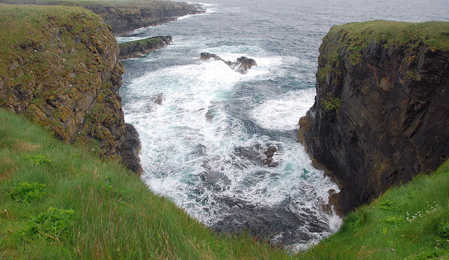
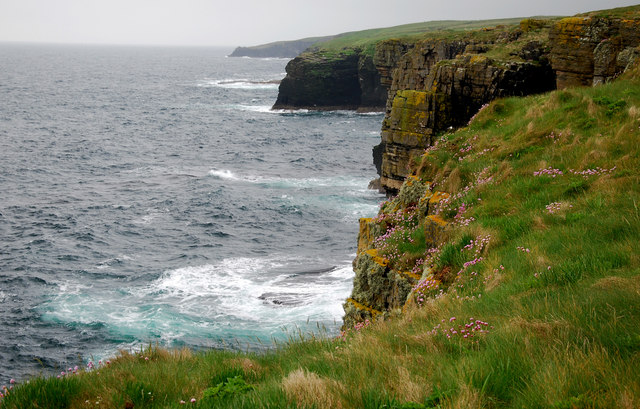
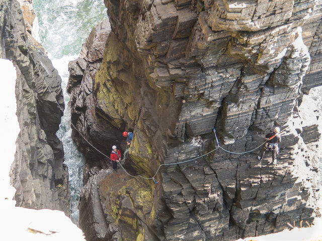
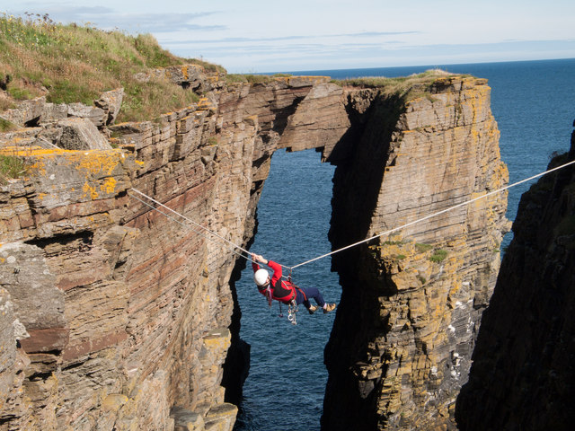
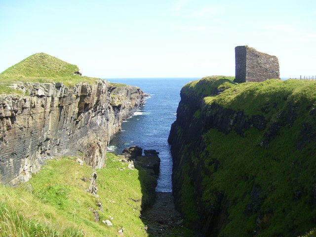
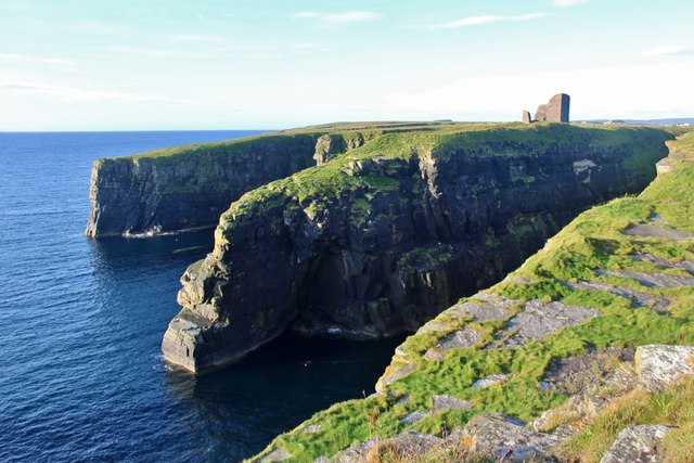
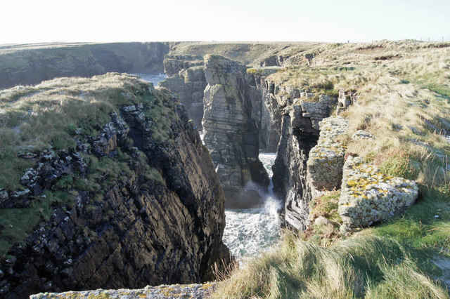
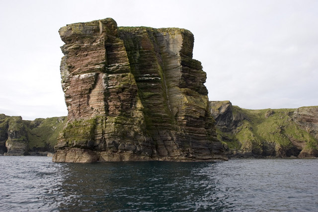
The headland at Fasberry juts out into the sea, forming a distinctive point that attracts nature enthusiasts and outdoor adventurers alike. Its rocky coastline is predominantly composed of sandstone and granite, which have been shaped over centuries by the relentless crashing waves and strong coastal winds. These geological forces have carved deep caves, towering sea stacks, and impressive arches into the cliffs, creating a visually striking and dynamic landscape.

The rugged beauty of Fasberry is complemented by its rich biodiversity. The headland is home to a wide range of plant and animal species, including seabird colonies, such as puffins, guillemots, and razorbills. The surrounding waters are also teeming with marine life, making it a popular spot for fishing and wildlife spotting.

Fasberry offers visitors a variety of outdoor activities. Hiking along the coastal paths allows visitors to explore the headland and enjoy panoramic views of the North Sea. Rock climbing enthusiasts can challenge themselves on the sheer cliffs, while birdwatchers can observe the diverse avian population that calls Fasberry home.

In summary, Fasberry, Caithness, is a captivating coastal feature renowned for its headland, distinct point, and unique geological formations. With its rugged cliffs, stunning views, and rich biodiversity, Fasberry offers a memorable experience for nature lovers and adventure seekers.

If you have any feedback on the listing, please let us know in the comments section below.
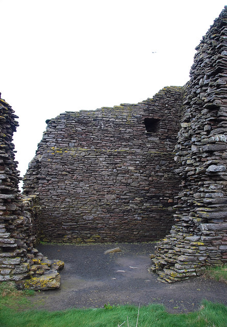
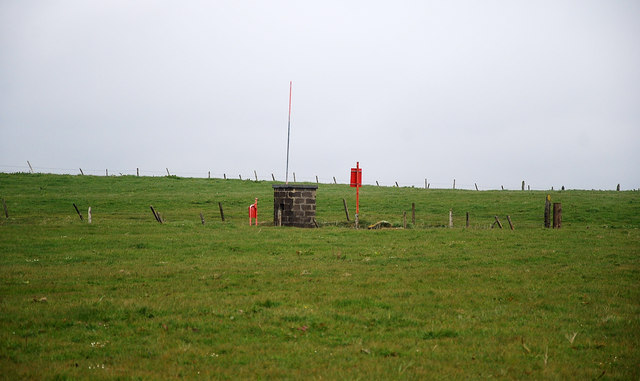
Fasberry Images

Images are sourced within 2km of 58.406007/-3.0885488 or Grid Reference ND3646. Thanks to Geograph Open Source API. All images are credited.

Foundation Remains All that remains of the foundations of a very large tourist information board in a layby on the A99.
The picture shows Nothfield Farm in the distance on the left and Wick is straight ahead on the horizon.
Foundation Remains
All that remains of the foundations of a very large tourist information board in a layby on the A99. The picture shows Nothfield Farm in the distance on the left and Wick is straight ahead on the horizon.
Castle of Old Wick The ruined remains of possibly the oldest castle in Scotland.  It was reputed to have been built by the half Norse, Earl of Caithness, Harald Maddadson, in the 1160's. It is now under the protection of Historic Scotland.
Castle of Old Wick
The ruined remains of possibly the oldest castle in Scotland. It was reputed to have been built by the half Norse, Earl of Caithness, Harald Maddadson, in the 1160's. It is now under the protection of Historic Scotland.
Sea Inlets The coastal scenery around the Old Castle of Wick is amazing with vertiginous cliffs, geos, arches, stacks and rocks that when there is a high sea with an accompanying wind the sea is tumultuous.
Sea Inlets
The coastal scenery around the Old Castle of Wick is amazing with vertiginous cliffs, geos, arches, stacks and rocks that when there is a high sea with an accompanying wind the sea is tumultuous.
MOD Rifle Range A rifle range with all the accoutrements including the sentry boxes when in use.
MOD Rifle Range
A rifle range with all the accoutrements including the sentry boxes when in use.
Headland View The high cliffs to the south of the headland supporting much pretty thrift or pinks as they are also known.
Headland View
The high cliffs to the south of the headland supporting much pretty thrift or pinks as they are also known.
Preparing to climb at the base of the stack As can be seen in <a href="https://www.geograph.org.uk/photo/303584">ND3648 : Sea Stack and Arch</a> there's only a narrow gap between the cliff opposite the stack and the stack itself.  Here we can see that we can get to the base of the stack by abseiling down the landward cliff and then jumping/swinging across to the stack.

Having climbed the stack the return can then be achieved by tyrolean traverse as in <a href="https://www.geograph.org.uk/photo/3510552">ND3648 : Returning from the stack</a> or by abseiling down the stack and then climbing up the cliff on the landward side.

Here the team are preparing to climb the southern face of the stack which, whilst not particularly difficult, is a tad loose.
Preparing to climb at the base of the stack
As can be seen in ND3648 : Sea Stack and Arch there's only a narrow gap between the cliff opposite the stack and the stack itself. Here we can see that we can get to the base of the stack by abseiling down the landward cliff and then jumping/swinging across to the stack. Having climbed the stack the return can then be achieved by tyrolean traverse as in ND3648 : Returning from the stack or by abseiling down the stack and then climbing up the cliff on the landward side. Here the team are preparing to climb the southern face of the stack which, whilst not particularly difficult, is a tad loose.
Returning from the stack As can be seen in <a href="https://www.geograph.org.uk/photo/3510548">ND3648 : Preparing to climb at the base of the stack</a> it is possible to abseil down the cliff opposite the stack and then jump/swing across onto the stack itself.  Having climbed the stack the easiest way back is bring up the abseil rope, set up a tyrolean traverse and to return on that.
Returning from the stack
As can be seen in ND3648 : Preparing to climb at the base of the stack it is possible to abseil down the cliff opposite the stack and then jump/swing across onto the stack itself. Having climbed the stack the easiest way back is bring up the abseil rope, set up a tyrolean traverse and to return on that.
Castle of Old Wick
Castle of Old Wick
Headland at Castle of Old Wick
Sea inlet near Castle of Old Wick
Stubble near Northfield Barley stubble awaiting ploughing.
Stubble near Northfield
Barley stubble awaiting ploughing.
Geo at The Castle of Old Wick The ruin of the castle is on the right - not looking too impressive in this picture - but dating from the twelfth century, it is one of Scotland's oldest castles. On the left is an earth mound, part of the now disused World War One rifle range which also occupies this site.
Geo at The Castle of Old Wick
The ruin of the castle is on the right - not looking too impressive in this picture - but dating from the twelfth century, it is one of Scotland's oldest castles. On the left is an earth mound, part of the now disused World War One rifle range which also occupies this site.
Coastline at South Point Cliffs, caves, stacks, arches and geos - this piece of coastline has them all.
Coastline at South Point
Cliffs, caves, stacks, arches and geos - this piece of coastline has them all.
Cliffs and sea stack Spectacular coastal features a mile or so south of Wick.
Cliffs and sea stack
Spectacular coastal features a mile or so south of Wick.
Cliffs south of Wick A spectacular section of coastline, with cliffs, geos, sea stacks and arches.
Cliffs south of Wick
A spectacular section of coastline, with cliffs, geos, sea stacks and arches.
Hempriggs House 2007 Exterior / side view of Hempriggs House 2007
Hempriggs House 2007
Exterior / side view of Hempriggs House 2007
Hempriggs House 2007 Hempriggs House 2007 outbuilding.
Hempriggs House 2007
Hempriggs House 2007 outbuilding.
Hempriggs House lintel stone Re used lintel stone on coach house, inscribed: CERI MANI MEMENTO MANE
Hempriggs House 2007
Hempriggs House lintel stone
Re used lintel stone on coach house, inscribed: CERI MANI MEMENTO MANE Hempriggs House 2007
Show me another place!

Fasberry is located at Grid Ref: ND3646 (Lat: 58.406007, Lng: -3.0885488)

Unitary Authority: Highland

Police Authority: Highlands and Islands

What 3 Words

///infants.knots.handbags. Near Wick, Highland

Related Wikis

Whiterow

Whiterow is a small coastal hamlet, on the east coast of Caithness, lying 1 mile southeast of Wick, Scottish Highlands. It is in the Scottish council area...

A99 road

The A99 road is entirely within the former county of Caithness in the Highland of Scotland. It runs generally north/northeast from the A9 at Latheron to...

Harmsworth Park

Harmsworth Park is a football ground in Wick in the Scottish Highlands of Scotland, which is the home ground of Highland Football League side Wick Academy...

Wick Town and County Hospital

Wick Town and County Hospital is a health facility in Seaforth Avenue, Wick, Scotland. It is managed by NHS Highland. == History == The facility, which...

Have you been to Fasberry?

Leave your review of Fasberry below (or comments, questions and feedback).