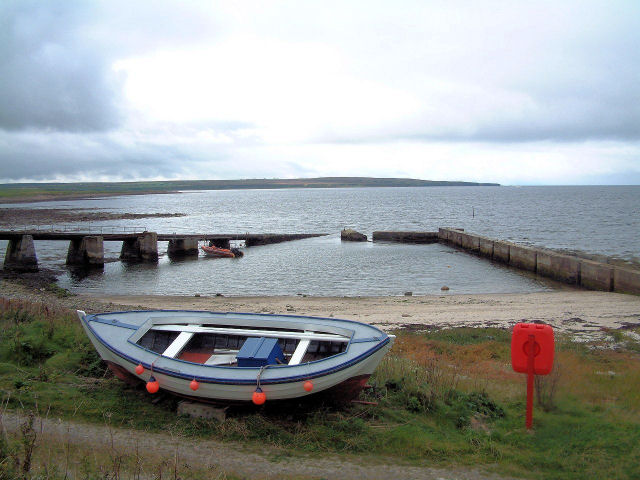
Ness of Huna

Coastal Feature, Headland, Point in Caithness

Scotland

Ness of Huna

The John O'Groats Hotel, Caithness John De Groot originally built his house round about the 1500s.  He ran a ferry to Orkney and charged 4 old pennies (less than 2p) a trip. The coin of this denomination subsequently became known as a Groat.
The John O'Groats Hotel, Caithness Credit: Dorcas Sinclair

Ness of Huna is a prominent coastal feature located in the county of Caithness, in the northernmost part of mainland Scotland. This headland, also known as a point, extends out into the North Sea, creating a distinctive and picturesque landscape.

Rising to a height of approximately 60 meters, Ness of Huna offers breathtaking panoramic views of the surrounding coastline and sea. Its steep cliffs, composed mainly of rugged sandstone, make it an impressive sight to behold. The headland is also home to a diverse range of flora and fauna, including various seabirds that nest on the cliffs, adding to the area's natural beauty.

Ness of Huna is a popular destination for nature enthusiasts and hikers, who are drawn to its stunning vistas and tranquil atmosphere. A well-maintained footpath leads visitors along the edge of the headland, allowing them to explore the area while enjoying the fresh sea breeze. On clear days, it is even possible to catch a glimpse of the Orkney Islands, which lie to the north.

Additionally, the headland boasts a rich historical heritage. Ruins of Iron Age brochs, ancient circular stone towers, can be found on the site, indicating human habitation in the area dating back thousands of years. These remnants serve as a testament to the enduring human connection to this remarkable coastal feature.

Overall, Ness of Huna in Caithness is a remarkable headland, offering visitors a combination of breathtaking natural scenery, wildlife, and a glimpse into the past.

If you have any feedback on the listing, please let us know in the comments section below.

Ness of Huna Images

Images are sourced within 2km of 58.64715/-3.1000795 or Grid Reference ND3673. Thanks to Geograph Open Source API. All images are credited.

The John O'Groats Hotel, Caithness John De Groot originally built his house round about the 1500s.  He ran a ferry to Orkney and charged 4 old pennies (less than 2p) a trip. The coin of this denomination subsequently became known as a Groat.
The John O'Groats Hotel, Caithness
John De Groot originally built his house round about the 1500s. He ran a ferry to Orkney and charged 4 old pennies (less than 2p) a trip. The coin of this denomination subsequently became known as a Groat.
Evening at John o' Groats Harbour A lovely calm evening.  The foot passenger ferry lying at anchor.
Evening at John o' Groats Harbour
A lovely calm evening. The foot passenger ferry lying at anchor.
Huna Pier Close to John O'Groats
Huna Pier
Close to John O'Groats
John O'Groats Signpost showing how far to various places and also the date 13 July, 1983. In the background we have the harbour with the Scouters Lass moored at the quayside on the right hand side of the harbour. The sea is calm and the visibility good, with some of the islands visible on the horizon.
John O'Groats
Signpost showing how far to various places and also the date 13 July, 1983. In the background we have the harbour with the Scouters Lass moored at the quayside on the right hand side of the harbour. The sea is calm and the visibility good, with some of the islands visible on the horizon.
'John O'Groats House' hotel On the shore of the Pentland Firth
'John O'Groats House' hotel
On the shore of the Pentland Firth
The harbour at John o' Groats
Last House Museum Museum at John O Groats, hotel in the background.
Last House Museum
Museum at John O Groats, hotel in the background.
The End is Nigh Signpost at John O'Groats.
The End is Nigh
Signpost at John O'Groats.
Boat at Huna Mounted by the Smithy Cottages, by the A936 at Huna.
Boat at Huna
Mounted by the Smithy Cottages, by the A936 at Huna.
Smithy Cottages B&B, Huna.
Smithy Cottages
B&B, Huna.
Old-fashioned Ship-to-Shore communications The 'village green' at Huna.
Old-fashioned Ship-to-Shore communications
The 'village green' at Huna.
John O'Groats (small) Mill A second mill, built adjacent to the first, in 1846. It superseded the first as the grain mill until that one was rebuilt in 1901; whereupon the second became a storehouse.
John O'Groats (small) Mill
A second mill, built adjacent to the first, in 1846. It superseded the first as the grain mill until that one was rebuilt in 1901; whereupon the second became a storehouse.
John O'Groats Mill An old grain mill from 1750, driven by waterwheel on a lade from the Duncansby Burn. The wooden projection at second storey level is a sack hoist; and the 'chimneys' to the right are ventillators from the grain drying kiln.
John O'Groats Mill
An old grain mill from 1750, driven by waterwheel on a lade from the Duncansby Burn. The wooden projection at second storey level is a sack hoist; and the 'chimneys' to the right are ventillators from the grain drying kiln.
Mill stream, John o'Groats Mill Fed by a dam and sluice system upstream, into which several local field drains feed.
Mill stream, John o'Groats Mill
Fed by a dam and sluice system upstream, into which several local field drains feed.
A pack-horse bridge over John o'Groats mill stream Close to where the stream enters the Pentland Firth. The bridge is a rubble-arch dating back to the 17th century.
A pack-horse bridge over John o'Groats mill stream
Close to where the stream enters the Pentland Firth. The bridge is a rubble-arch dating back to the 17th century.
The Millhouse, John o'Groats Lawnmowing in progress in a steady drizzle.
The Millhouse, John o'Groats
Lawnmowing in progress in a steady drizzle.
John o'Groats Mill In common with most buildings along the north coast, the roof is covered in lichens. Testimony I am told to the purity of the air.
John o'Groats Mill
In common with most buildings along the north coast, the roof is covered in lichens. Testimony I am told to the purity of the air.
John o'Groats Craft Centre
Show me another place!

Ness of Huna is located at Grid Ref: ND3673 (Lat: 58.64715, Lng: -3.1000795)

Unitary Authority: Highland

Police Authority: Highlands and Islands

What 3 Words

///fever.slanting.truck. Near John o' Groats, Highland

Related Wikis

Huna House

Huna House is a Victorian building located in the small village of Huna in Canisbay, north of Caithness. Built in 1870 as the Huna Hotel, it is listed...

Huna, Caithness

Huna is a small remote crofting township, located 1 mile northeast of Canisbay and 1.5 miles west of John o' Groats in Caithness, in Scotland. It is currently...

MeyGen

MeyGen (full name MeyGen tidal energy project) will be the world's largest tidal energy plant, which is currently in construction. The first phase of the...

John o' Groats

John O' Groats (Scottish Gaelic: Taigh Iain Ghròt) is a village 2.5 mi (4 km) northeast of Canisbay, Caithness, in the far north of Scotland. John O' Groats...

Canisbay Parish Church

Canisbay Parish Church is a Church of Scotland church in Canisbay, Scotland, that dates back to the early 1600s and is the most northernly church on mainland...

Canisbay

Canisbay is a rural hamlet located about one mile (1.5 kilometres) southwest of Huna and two and a half miles (four kilometres) southwest of John o' Groats...

Gills Bay

Gills Bay, which is situated about 3 mi (4.8 km) west of John o' Groats with the community of Gills close by, has one of the longest stretches of low-lying...

Island of Stroma

Stroma is an uninhabited island in the Pentland Firth, between Orkney and the mainland of Scotland. It forms part of the civil parish of Canisbay in Caithness...

Nearby Amenities

Located within 500m of 58.64715,-3.1000795
Source: PGS
Lat/Long: 58.6460479/-3.0919865
Source: PGS
Lat/Long: 58.6462907/-3.0921807
Source: PGS
Lat/Long: 58.6466369/-3.0930411
Source: PGS
Lat/Long: 58.6466483/-3.0932713
Source: PGS
Lat/Long: 58.646804/-3.0937412
Source: PGS
Lat/Long: 58.6468244/-3.0945512
Source: PGS
Lat/Long: 58.6468213/-3.0964175
Source: PGS
Lat/Long: 58.6467292/-3.0969754
Source: PGS
Lat/Long: 58.6467546/-3.0975424
Source: PGS
Lat/Long: 58.6467013/-3.0976846
Source: PGS
Lat/Long: 58.6466938/-3.0977833
Source: PGS
Lat/Long: 58.6466539/-3.0982827
Source: PGS
Lat/Long: 58.6466201/-3.0989034
Source: PGS
Lat/Long: 58.6466374/-3.0999982
Source: PGS
Lat/Long: 58.6464708/-3.1013168
Source: PGS
Lat/Long: 58.6463976/-3.1019482
Source: PGS
Lat/Long: 58.6463189/-3.1028124
Source: os open data
Lat/Long: 58.6462232/-3.1035318
Source: PGS
Lat/Long: 58.6460607/-3.1043338
Source: PGS
Lat/Long: 58.6457724/-3.1051454
Source: PGS
Lat/Long: 58.6455301/-3.1057119
Source: PGS
Lat/Long: 58.6453373/-3.106082
Source: PGS
Lat/Long: 58.6450389/-3.1064634
Source: PGS
Lat/Long: 58.6447519/-3.1068277
Power: pole
Lat/Long: 58.6429344/-3.0978849
Power: pole
Lat/Long: 58.6429492/-3.0991093
Power: pole
Lat/Long: 58.6429482/-3.1003255
Power: pole
Lat/Long: 58.6430052/-3.1016351
Power: pole
Lat/Long: 58.6430728/-3.1029711
Power: pole
Lat/Long: 58.6434199/-3.1003488
Power: pole
Lat/Long: 58.6443423/-3.1003935
Power: pole
Lat/Long: 58.644711/-3.1010493
Power: pole
Lat/Long: 58.6450681/-3.101695
Power: pole
Lat/Long: 58.6453924/-3.1022614
The data included in this document is from www.openstreetmap.org. The data is made available under ODbL.

Have you been to Ness of Huna?

Leave your review of Ness of Huna below (or comments, questions and feedback).