Arkle
Coastal Feature, Headland, Point in Caithness
Scotland
Arkle

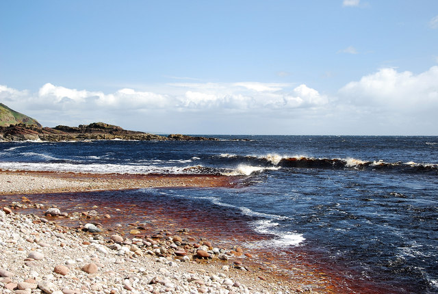
Arkle is a prominent headland located on the northern coast of Caithness, Scotland. Situated approximately 3 miles northwest of the village of Reay, Arkle stands tall and commands attention with its rugged cliffs and dramatic landscape.
This coastal feature is known for its distinctive triangular shape, jutting out into the North Sea. Rising to a height of 197 meters (646 feet), Arkle offers breathtaking panoramic views of the surrounding coastline and the wild sea beyond.
The headland is primarily composed of sandstone and has been shaped by the relentless force of the waves over millions of years. The cliffs exhibit intricate geological formations, including caves, sea stacks, and natural arches, which are a haven for seabirds such as guillemots, kittiwakes, and fulmars.
Arkle is also renowned for its rich history. The headland is believed to have been occupied by humans since prehistoric times, with archaeological evidence suggesting the presence of Neolithic settlements. It is also rumored to have been a Viking stronghold during the medieval period.
Today, Arkle is a popular destination for hikers and nature enthusiasts. There are several trails that lead to the headland, offering opportunities to explore its diverse flora and fauna. The coastal path provides stunning views of the surrounding cliffs and sea, while the heathland on top of Arkle is home to a variety of plant species, including heather and wildflowers.
In summary, Arkle is a striking headland on the Caithness coast, boasting magnificent cliffs, breathtaking vistas, and a rich historical heritage. It continues to captivate visitors with its natural beauty and is a must-visit destination for anyone exploring the northern reaches of Scotland.
If you have any feedback on the listing, please let us know in the comments section below.
Arkle Images
Images are sourced within 2km of 58.18307/-3.5027282 or Grid Reference ND1122. Thanks to Geograph Open Source API. All images are credited.


Arkle is located at Grid Ref: ND1122 (Lat: 58.18307, Lng: -3.5027282)
Unitary Authority: Highland
Police Authority: Highlands and Islands
What 3 Words
///crucially.pocket.quilt. Near Dunbeath, Highland
Nearby Locations
Related Wikis

Berriedale Water
Berriedale Water is a short river in Caithness in northern Scotland. It arises as the Feith Gaineimh Mhor, Feith Chaorunn Mhor and Feith Fhuaran come together...

Berriedale Castle
Berriedale Castle is a ruined castle located on a promontory on the south of the entrance to the Berriedale Water, Caithness in Scotland. == Structure... ==

Berriedale Church
Berriedale Church is a former church in the parish of Latheron, in Berriedale, Caithness, Scotland. Built in 1826, the T-plan building was closed as a...

Berriedale, Highland
Berriedale (Scottish Gaelic: Bearghdal) is a small estate village on the northern east coast of Caithness, Scotland, on the A9 road between Helmsdale and...
Borgue, Highland
Borgue is a village in the historical county of Caithness, 3 miles (5 km) south of Dunbeath in the local authority are of Highland, Scotland.Rev Samuel...
Newport, Caithness
Newport is a small remote village on the eastern shore of Caithness, Scottish Highlands and is in the Scottish council area of Highland.Ramscraig lies...

Badbea
Badbea (pronounced bad-bay) is a former clearance village perched on the steep slopes above the cliff tops of Berriedale on the east coast of Caithness...
Ramscraig
Ramscraig is a small scattered crofting hamlet, located 2 miles southwest from Dunbeath, in eastern Caithness, Scottish Highlands and is in the Scottish...
Nearby Amenities
Located within 500m of 58.18307,-3.5027282Have you been to Arkle?
Leave your review of Arkle below (or comments, questions and feedback).