Fleswick

Coastal Feature, Headland, Point in Cumberland Copeland

England

Fleswick

The bird ledges at St Bees Head Thousands of sea birds nest here - some are just visible. The white streaks are from their droppings.
The bird ledges at St Bees Head Credit: David Medcalf

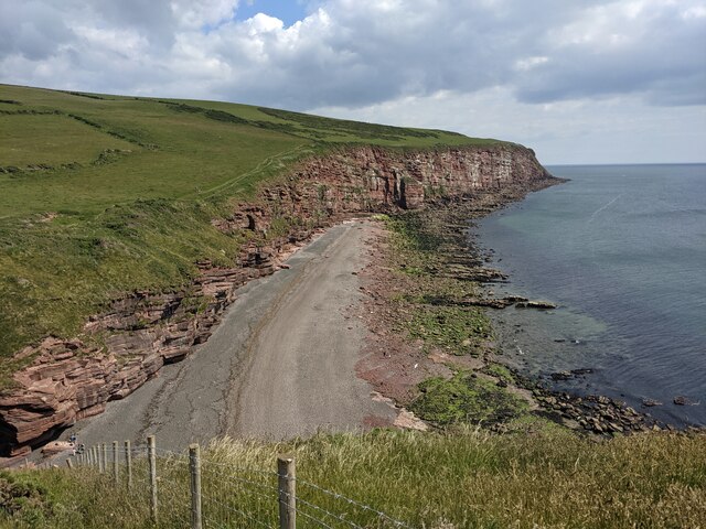
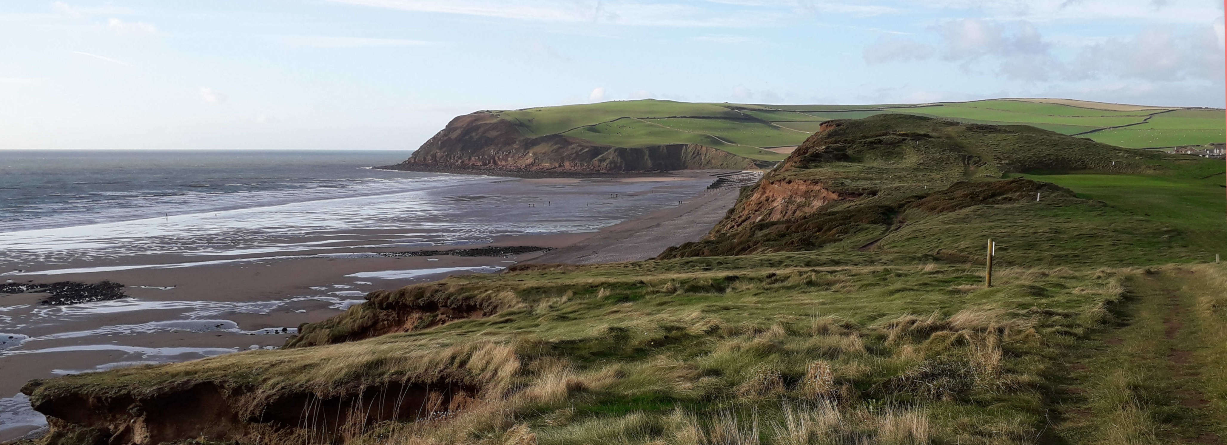
Fleswick is a picturesque headland located in the county of Cumberland, England. Situated along the stunning coastline, this coastal feature is renowned for its rugged beauty and dramatic cliffs that overlook the Irish Sea.

The headland is characterized by its prominent position, jutting out into the sea, forming a distinct point that provides breathtaking panoramic views of the surrounding landscape. Fleswick is located near the village of St Bees, and is a popular destination for tourists and locals alike, who come to admire its natural beauty and enjoy the tranquility it offers.

The cliffs of Fleswick are a striking feature of the headland, towering above the crashing waves below. Composed of sedimentary rock, these cliffs have been shaped by the relentless force of the sea over thousands of years, resulting in their impressive height and rugged appearance.

The surrounding area of Fleswick is also home to a diverse range of flora and fauna. The headland provides a vital habitat for various bird species, including nesting seabirds such as kittiwakes, fulmars, and guillemots. Visitors to Fleswick may spot these remarkable creatures gliding above the cliffs or perched on the rocky ledges.

For those seeking adventure, Fleswick offers opportunities for coastal walks and exploration. The headland is part of the Cumbria Coastal Way, a long-distance footpath that stretches along the entire length of the county's coastline. Hikers can enjoy the challenging terrain and stunning views as they traverse the area.

In conclusion, Fleswick in Cumberland is a captivating headland that showcases the natural beauty of England's coastline. With its breathtaking cliffs, diverse wildlife, and scenic walks, Fleswick is a must-visit destination for nature enthusiasts and those seeking an escape into the rugged charm of the coastal landscape.

If you have any feedback on the listing, please let us know in the comments section below.

Fleswick Images

Images are sourced within 2km of 54.504988/-3.6295662 or Grid Reference NX9413. Thanks to Geograph Open Source API. All images are credited.

The bird ledges at St Bees Head Thousands of sea birds nest here - some are just visible. The white streaks are from their droppings.
The bird ledges at St Bees Head
Thousands of sea birds nest here - some are just visible. The white streaks are from their droppings.
Gate and fishing boat On the Coast Path.
Gate and fishing boat
On the Coast Path.
Ground slump field? I think the land has dropped seawards here, creating a convenient small field.
Ground slump field?
I think the land has dropped seawards here, creating a convenient small field.
Down the steps to Fleswick On the Coast Path.
Down the steps to Fleswick
On the Coast Path.
Rock architecture at Fleswick
A field above Fleswick
Coastline at St Bees Head
Broken stile and locked gate On the public footpath.
Broken stile and locked gate
On the public footpath.
Farm track and footpath
Hannahmoor Lane
Hannahmoor Lane
St. Bees Head The 75m high red sandstone cliffs of St. Bees North Head.
The Cumbria Coastal Way runs along the cliff top behind the post and wire fence.
St. Bees Head
The 75m high red sandstone cliffs of St. Bees North Head. The Cumbria Coastal Way runs along the cliff top behind the post and wire fence.
St. Bees Lighthouse
St. Bees Lighthouse
St. Bees Lighthouse The substantial stone wall separates a lawned area in front of the lighthouse from the farmer's field in the foreground.
St. Bees Lighthouse
The substantial stone wall separates a lawned area in front of the lighthouse from the farmer's field in the foreground.
Dramatic coastline by the Cumbria Coastal Way Whitehaven is in the distance: time to glimpse back en route to St Bees Head.

This photograph was taken during the Coronavirus (COVID-19) pandemic of 2020/21/22.
Dramatic coastline by the Cumbria Coastal Way
Whitehaven is in the distance: time to glimpse back en route to St Bees Head. This photograph was taken during the Coronavirus (COVID-19) pandemic of 2020/21/22.
On the Cumbria Coastal Way near North Head An easy section of the Way with spectacular views.

This photograph was taken during the Coronavirus (COVID-19) pandemic of 2020/21/22.
On the Cumbria Coastal Way near North Head
An easy section of the Way with spectacular views. This photograph was taken during the Coronavirus (COVID-19) pandemic of 2020/21/22.
St Bees Head fog signal station The disused triple frequency Tannoy fog signal station which was operational from the 1960s until 1987.  The building had 36 Tannoy loudspeakers, the recesses for two can be noted on the tower above the roof line of the building.

This photograph was taken during the Coronavirus (COVID-19) pandemic of 2020/21/22.
St Bees Head fog signal station
The disused triple frequency Tannoy fog signal station which was operational from the 1960s until 1987. The building had 36 Tannoy loudspeakers, the recesses for two can be noted on the tower above the roof line of the building. This photograph was taken during the Coronavirus (COVID-19) pandemic of 2020/21/22.
St Bees Head fog signal station and the Solway Firth The view near St Bees Lighthouse on a beautiful early March afternoon encompasses the fog signal station, Solway Firth and Scottish coastline.

This photograph was taken during the Coronavirus (COVID-19) pandemic of 2020/21/22.
St Bees Head fog signal station and the Solway Firth
The view near St Bees Lighthouse on a beautiful early March afternoon encompasses the fog signal station, Solway Firth and Scottish coastline. This photograph was taken during the Coronavirus (COVID-19) pandemic of 2020/21/22.
St Bees Lighthouse On St Bees Head. Automated and unmanned since 1987. The building in the foreground was presumably used for lighthouse keepers' accommodation.
St Bees Lighthouse
On St Bees Head. Automated and unmanned since 1987. The building in the foreground was presumably used for lighthouse keepers' accommodation.
Show me another place!

Fleswick is located at Grid Ref: NX9413 (Lat: 54.504988, Lng: -3.6295662)

Administrative County: Cumbria

District: Copeland

Police Authority: Cumbria

What 3 Words

///courtyard.kicked.garlic. Near St Bees, Cumbria

Nearby Locations

Fleswick

Related Wikis

St Bees Head

St Bees Head is a headland on the North West coast of the English county of Cumbria and is named after the nearby village of St Bees. It is the only stretch...
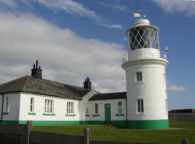
St Bees Lighthouse

St Bees Lighthouse is a lighthouse located on St Bees Head near the village of St Bees in Cumbria, England. The cliff-top light is the highest in England...

Rottington

Rottington is a hamlet and former civil parish which is 3 miles (4.8 km) from Whitehaven; now in the parish of St Bees, Cumberland, Cumbria, England. It...

St Bees Head RSPB reserve

St Bees Head RSPB Reserve at St Bees Head, Cumbria, England, is a coastal site which provides a home for thousands of seabirds under the care of the RSPB...

Nearby Amenities

Located within 500m of 54.504988,-3.6295662
Source: PGS
Lat/Long: 54.5072683/-3.6360069
Source: PGS
Lat/Long: 54.5068679/-3.6359871
Source: PGS
Lat/Long: 54.5067608/-3.6354198
Source: PGS
Lat/Long: 54.506183/-3.6350776
Source: PGS
Lat/Long: 54.5059477/-3.6344787
Source: PGS
Lat/Long: 54.5056626/-3.6344757
Source: PGS
Lat/Long: 54.5053962/-3.6342966
Created By: almien_coastlines
Source: PGS
Lat/Long: 54.5050503/-3.633712
Created By: almien_coastlines
Source: PGS
Lat/Long: 54.5048364/-3.6334291
Created By: almien_coastlines
Source: PGS
Lat/Long: 54.5046843/-3.6331632
Source: PGS
Lat/Long: 54.5044272/-3.6324007
Source: PGS
Lat/Long: 54.5043504/-3.6318315
Source: PGS
Lat/Long: 54.5043957/-3.631018
Source: PGS
Lat/Long: 54.5040307/-3.6301632
Source: PGS
Lat/Long: 54.5037879/-3.6297445
Source: PGS
Lat/Long: 54.5035336/-3.6293545
Source: PGS
Lat/Long: 54.5033761/-3.6290847
Source: PGS
Lat/Long: 54.5032205/-3.628868
Source: PGS
Lat/Long: 54.5030171/-3.6285622
Source: PGS
Lat/Long: 54.5028754/-3.628294
Source: PGS
Lat/Long: 54.5027002/-3.6279633
Source: PGS
Lat/Long: 54.5025221/-3.6276655
Source: PGS
Lat/Long: 54.5022848/-3.6272899
Source: PGS
Lat/Long: 54.5020869/-3.6270896
Barrier: kissing_gate
Foot: designated
Source: PGS
Lat/Long: 54.5021496/-3.6266496
Source: PGS
Lat/Long: 54.5019113/-3.6265336
Barrier: kissing_gate
Foot: designated
Lat/Long: 54.5069818/-3.6353659
Barrier: stile
Lat/Long: 54.5049211/-3.6290968
Fleswick Bay
Place: locality
Lat/Long: 54.5044035/-3.6306324
Barrier: kissing_gate
Source: survey;gps
Lat/Long: 54.5045361/-3.6299095
The data included in this document is from www.openstreetmap.org. The data is made available under ODbL.

Have you been to Fleswick?

Leave your review of Fleswick below (or comments, questions and feedback).