The Goat

Coastal Feature, Headland, Point in Devon South Hams

England

The Goat

Soar Mill Cove Low tide on Soar Mill Cove reveals a secluded sandy beach.
Soar Mill Cove Credit: Philip Halling

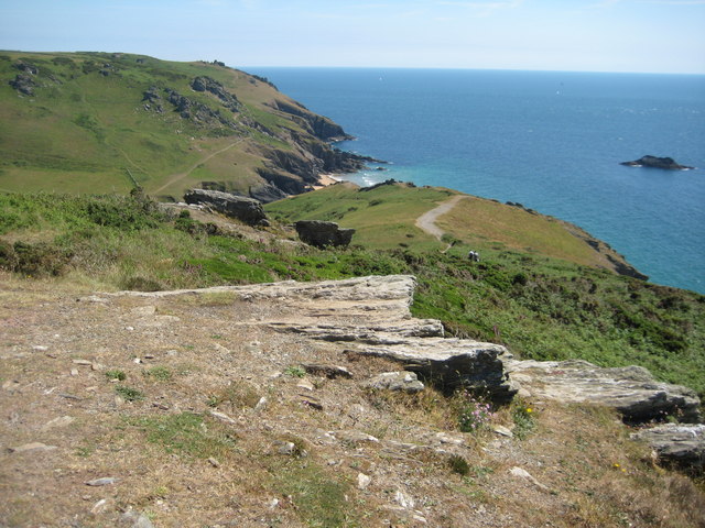
The Goat, Devon, is a prominent coastal feature located in the southwestern part of England. It is a headland or point that juts out into the Atlantic Ocean, offering breathtaking views of the surrounding coastline.

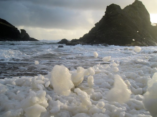
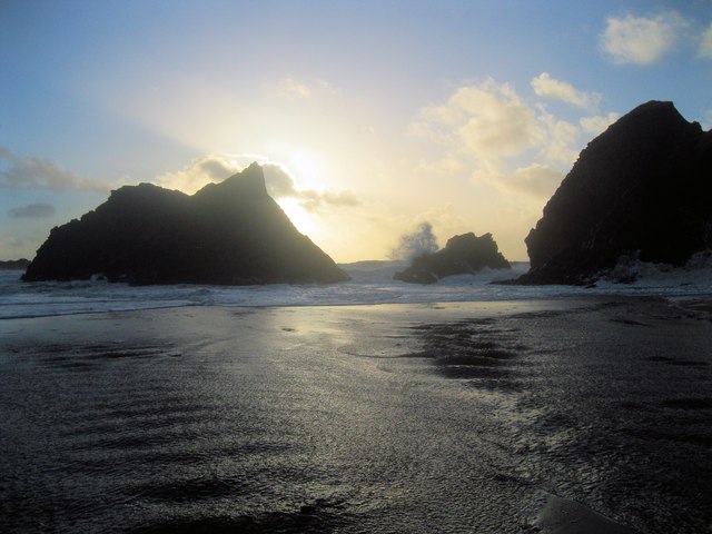
The Goat is known for its rugged and dramatic cliffs, which are made of sedimentary rocks, mainly sandstone and limestone. These cliffs rise to a considerable height, providing an impressive backdrop to the crashing waves below. The exposed rocks display distinctive layers, showcasing the geological history of the area.

The headland is a popular destination for nature enthusiasts and hikers, offering a network of well-maintained trails that allow visitors to explore the area. The paths wind through heathland and grassy meadows, providing opportunities to observe a variety of flora and fauna, including wildflowers, seabirds, and even the occasional seal.

At the tip of The Goat, there is a viewpoint that provides panoramic vistas of the surrounding coastline, with its picturesque coves and sandy beaches. On clear days, visitors can see as far as the horizon, and the sight of the sun setting over the ocean is particularly awe-inspiring.

The Goat is also of historical significance, as it was once used as a lookout point during World War II. Remnants of military structures and bunkers can still be seen in certain areas, serving as a reminder of the area's past.

Overall, The Goat is a stunning coastal feature that offers a captivating blend of natural beauty, geological wonders, and historical intrigue. It is a must-visit destination for anyone seeking to experience the rugged charm of the Devon coastline.

If you have any feedback on the listing, please let us know in the comments section below.

The Goat Images

Images are sourced within 2km of 50.21595/-3.8122538 or Grid Reference SX7036. Thanks to Geograph Open Source API. All images are credited.

Soar Mill Cove Low tide on Soar Mill Cove reveals a secluded sandy beach.
Soar Mill Cove
Low tide on Soar Mill Cove reveals a secluded sandy beach.
Sea caves at Soar Mill Cove Low tide at Soar Mill Cove reveals these sea caves at the back of the beach.
Sea caves at Soar Mill Cove
Low tide at Soar Mill Cove reveals these sea caves at the back of the beach.
Cattle above Soar Mill Cove Cattle graze on the raised beach behind the cove, to the consternation of some visiting children. "How do I get past them?", one small boy asked me. Considering he'd just walked from Bolberry Down, they seemed a very minor impediment.
Cattle above Soar Mill Cove
Cattle graze on the raised beach behind the cove, to the consternation of some visiting children. "How do I get past them?", one small boy asked me. Considering he'd just walked from Bolberry Down, they seemed a very minor impediment.
Ham Stone From a narrow piece of clifftop grassland that juts into the square.
Ham Stone
From a narrow piece of clifftop grassland that juts into the square.
Above Cathole Cliff View over Soar Mill Cove from the South West Coast Path above Cathole Cliff.
Above Cathole Cliff
View over Soar Mill Cove from the South West Coast Path above Cathole Cliff.
Windy winter's evening at Soar Mill Cove Flecks of foam are blowing inland, covering much of the beach.
Windy winter's evening at Soar Mill Cove
Flecks of foam are blowing inland, covering much of the beach.
Late afternoon at Soar Mill Cove Waves are breaking over the rocks at the entrance to the cove, and flecks of foam are covering the seaward end of the sandy beach.
Late afternoon at Soar Mill Cove
Waves are breaking over the rocks at the entrance to the cove, and flecks of foam are covering the seaward end of the sandy beach.
Steep path down to Soar Mill Cove Looking lovely with the Blue Bells all around.
Steep path down to Soar Mill Cove
Looking lovely with the Blue Bells all around.
Footbridge, Soar Mill Cove Crossing the stream just before it reaches the beach.
Footbridge, Soar Mill Cove
Crossing the stream just before it reaches the beach.
Soar Mill Cove
Soar Mill Cove
Path junction Both routes lead to Bolberry Down, left is the much harder route but shorter and right follows the valley around the high point of Cathole Point and below Hazel Tor. I chose the shorter route.
Path junction
Both routes lead to Bolberry Down, left is the much harder route but shorter and right follows the valley around the high point of Cathole Point and below Hazel Tor. I chose the shorter route.
Looking down the valley in the direction of Soar Mill Cove Soar Mill Cove in the distance in SX6937.
Looking down the valley in the direction of Soar Mill Cove
Soar Mill Cove in the distance in SX6937.
Isolated house By the track to Southdown Farm.
Isolated house
By the track to Southdown Farm.
Approaching Southdown Farm It appears as if most of the farm buildings have been turned into self catering accommodation by the National Trust who own the farm.
Approaching Southdown Farm
It appears as if most of the farm buildings have been turned into self catering accommodation by the National Trust who own the farm.
Bench above Cathole Cliff Bench on the South West Coast Path above Cathole Cliff.
Bench above Cathole Cliff
Bench on the South West Coast Path above Cathole Cliff.
View to West Soar View to West Soar from the coast path above Cathole Point.
View to West Soar
View to West Soar from the coast path above Cathole Point.
Beach at Soar Mill Cove A remote and quiet beach at Soar Mill Cove.
Beach at Soar Mill Cove
A remote and quiet beach at Soar Mill Cove.
The beach at Soar Mill Cove Beautiful quiet sandy beach at Soar Mill Cove.
The beach at Soar Mill Cove
Beautiful quiet sandy beach at Soar Mill Cove.
Show me another place!

The Goat is located at Grid Ref: SX7036 (Lat: 50.21595, Lng: -3.8122538)

Administrative County: Devon

District: South Hams

Police Authority: Devon and Cornwall

What 3 Words

///basket.perfected.hobble. Near Salcombe, Devon

Related Wikis

RAF Bolt Head

Royal Air Force Bolt Head or more simply RAF Bolt Head is a former Royal Air Force satellite airfield 1 mile (1.6 km) south west of Salcombe on the south...

RAF Hope Cove

Royal Air Force Hope Cove or more simply RAF Hope Cove is a former Royal Air Force radar station. It is located about 1 mile (1.6 km) south west of Salcombe...

Bolt Head

Bolt Head is a National Trust headland on the South Coast of Devon, England, United Kingdom, situated west of the Kingsbridge Estuary. It is a popular...

Bolberry

Bolberry is a hamlet on the south coast of Devon, England. The village is mentioned in Domesday Book in 1066 and 1086, which shows the land was of little...

Nearby Amenities

Located within 500m of 50.21595,-3.8122538
Steeple Cove
Place: locality
Source: NPE
Lat/Long: 50.2159538/-3.8177912
The Goat
Place: locality
Lat/Long: 50.2161843/-3.8125699
Little Goat
Place: locality
Lat/Long: 50.2151207/-3.8097944
Bench
Backrest: no
Lat/Long: 50.2164291/-3.8099114
West Soar Signalling Station Info
Board Type: history
Information: board
Operator: South Devon AONB
Tourism: information
Lat/Long: 50.2198512/-3.814967
The data included in this document is from www.openstreetmap.org. The data is made available under ODbL.

Have you been to The Goat?

Leave your review of The Goat below (or comments, questions and feedback).