Craig y Delyn

Coastal Feature, Headland, Point in Cardiganshire

Wales

Craig y Delyn

Path becomes a metalled road By Cillolwg farm, above Borth.
Path becomes a metalled road Credit: John Lucas

Craig y Delyn is a prominent headland located on the coast of Cardiganshire, Wales. Situated between the picturesque villages of Tresaith and Aberporth, this coastal feature offers breathtaking views of the Irish Sea and the surrounding rugged landscape.

The headland is characterized by its towering cliffs, which reach heights of up to 200 feet in some areas. These cliffs are composed of layers of sedimentary rock, providing a glimpse into the area's geological history. The rock formations are often weathered and eroded, creating fascinating shapes and patterns.

At the tip of Craig y Delyn, there is a distinctive point that juts out into the sea. This point is a popular spot for birdwatching enthusiasts, as it provides an ideal vantage point to observe a variety of seabirds, including gulls, razorbills, and fulmars. Additionally, the headland is home to a diverse range of plant species, including heather, gorse, and sea thrift, which thrive in the exposed coastal environment.

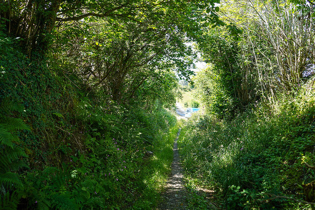
Access to Craig y Delyn is relatively easy, with a well-maintained coastal path that runs along the cliff tops. This path offers visitors the opportunity to explore the headland's natural beauty while enjoying invigorating walks and hikes. Along the way, visitors can also discover hidden coves and secluded beaches, perfect for picnicking or taking a refreshing dip in the sea.

Overall, Craig y Delyn is a captivating coastal feature that combines stunning geological formations, abundant wildlife, and breathtaking views. It is a must-visit destination for nature lovers and those seeking a peaceful retreat in the heart of Cardiganshire's scenic coastline.

If you have any feedback on the listing, please let us know in the comments section below.

Craig y Delyn Images

Images are sourced within 2km of 52.468929/-4.067994 or Grid Reference SN5987. Thanks to Geograph Open Source API. All images are credited.

Path becomes a metalled road By Cillolwg farm, above Borth.
Path becomes a metalled road
By Cillolwg farm, above Borth.
Minor roads crossing  In the hills above Borth.
Minor roads crossing
In the hills above Borth.
Minor road heading down to Upper Borth
Sat nav error! The sign announces that the road is private and is no through road - 'SAT NAV ERROR!'. However, it is a bridleway, as shown by the sign on the right.
Sat nav error!
The sign announces that the road is private and is no through road - 'SAT NAV ERROR!'. However, it is a bridleway, as shown by the sign on the right.
On the old road from Llandre to Borth
Descending towards Borth from Upper Borth
Upper Borth viewed from Borth esplanade With Borth War Memorial set on the hill above.
Upper Borth viewed from Borth esplanade
With Borth War Memorial set on the hill above.
Ordnance Survey Cut Mark This OS cut mark can be found on Frondirion east side of the road. It marks a point 33.711m above mean sea level.
Ordnance Survey Cut Mark
This OS cut mark can be found on Frondirion east side of the road. It marks a point 33.711m above mean sea level.
Ordnance Survey Rivet This OS rivet can be found on the boulder west side of the road. It marks a point 71.610m above mean sea level.
Ordnance Survey Rivet
This OS rivet can be found on the boulder west side of the road. It marks a point 71.610m above mean sea level.
B4572 near Upper Borth
Upper Borth viewed from Borth Borth War Memorial stand prominently above the cliff.
Upper Borth viewed from Borth
Borth War Memorial stand prominently above the cliff.
Borth on a wet Christmas Day
Craig yr Wylfa Surmounted by the Borth War Memorial.
Craig yr Wylfa
Surmounted by the Borth War Memorial.
Borth Beach in January Few folk venturing out on a cold January day; at the moment, Aberdyfi in the distance is sole possessor of the sun.
Borth Beach in January
Few folk venturing out on a cold January day; at the moment, Aberdyfi in the distance is sole possessor of the sun.
Artificial reefs off Borth Intended to protect the village from the worst of the seas.
Artificial reefs off Borth
Intended to protect the village from the worst of the seas.
Craig yr Wylfa, late on a January day A struggling sun is disappearing under cloud and sea mist.
Craig yr Wylfa, late on a January day
A struggling sun is disappearing under cloud and sea mist.
On the sands at Borth, Ceredigion Beautiful Borth.
On the sands at Borth, Ceredigion
Beautiful Borth.
Offshore breakwaters at Borth These have been here since maybe 2012 and seem to be doing their job.
Offshore breakwaters at Borth
These have been here since maybe 2012 and seem to be doing their job.
Show me another place!

Craig y Delyn is located at Grid Ref: SN5987 (Lat: 52.468929, Lng: -4.067994)

Unitary Authority: Ceredigion

Police Authority: Dyfed Powys

What 3 Words

///blunders.coveted.foremost. Near Borth, Ceredigion

Nearby Locations

Craig y Delyn

Related Wikis

Upper Borth

Upper Borth is a small village in Ceredigion, Wales, part of Borth.

Rhyd-Meirionnydd

Rhyd Meirionnydd (wrongly spelt: Rhyd-meirionydd) is a small village in the community of Genau'r-glyn, Ceredigion, Wales, which is 77.3 miles (124.3 km...

Llangorwen

Llangorwen is a village located in the county of Ceredigion, Mid-Wales. Close to Clarach Bay and a mile north of Aberystwyth. The Church of All Saints...

Wallog

Wallog is a beach on the coast of Cardigan Bay north of Aberystwyth between Clarach Bay and Borth in the county of Ceredigion, Mid-Wales. A shingle spit...

Nearby Amenities

Located within 500m of 52.468929,-4.067994
Created By: dmgroom_coastlines
Source: PGS
Lat/Long: 52.472274/-4.063581
Created By: dmgroom_coastlines
Source: PGS
Lat/Long: 52.4717217/-4.0639119
Created By: dmgroom_coastlines
Source: PGS
Lat/Long: 52.4711646/-4.0645022
Created By: dmgroom_coastlines
Source: PGS
Lat/Long: 52.470726/-4.064803
Created By: dmgroom_coastlines
Source: PGS
Lat/Long: 52.4705059/-4.0650205
Created By: dmgroom_coastlines
Source: PGS
Lat/Long: 52.470332/-4.065841
Created By: dmgroom_coastlines
Source: PGS
Lat/Long: 52.4702/-4.066258
Created By: dmgroom_coastlines
Source: PGS
Lat/Long: 52.469686/-4.066456
Created By: dmgroom_coastlines
Source: PGS
Lat/Long: 52.469426/-4.066869
Created By: dmgroom_coastlines
Source: PGS
Lat/Long: 52.46891/-4.067276
Created By: dmgroom_coastlines
Source: PGS
Lat/Long: 52.468137/-4.067677
Created By: dmgroom_coastlines
Source: PGS
Lat/Long: 52.467363/-4.068287
Created By: dmgroom_coastlines
Source: PGS
Lat/Long: 52.4668677/-4.0684107
Created By: dmgroom_coastlines
Source: PGS
Lat/Long: 52.466337/-4.068473
Source: PGS
Lat/Long: 52.4655324/-4.0684109
Source: PGS
Lat/Long: 52.4645691/-4.0681232
The data included in this document is from www.openstreetmap.org. The data is made available under ODbL.

Have you been to Craig y Delyn?

Leave your review of Craig y Delyn below (or comments, questions and feedback).