Geodha an t-Srathain

Coastal Feature, Headland, Point in Sutherland

Scotland

Geodha an t-Srathain

Shieling on the Moine The remains of a shieling hut, unmarked on the OS map. It is situated close to Allt Larach na h-Airigh, the name of which indicates that summer grazing took place at the location (Airigh = Shieling).
Shieling on the Moine Credit: david glass

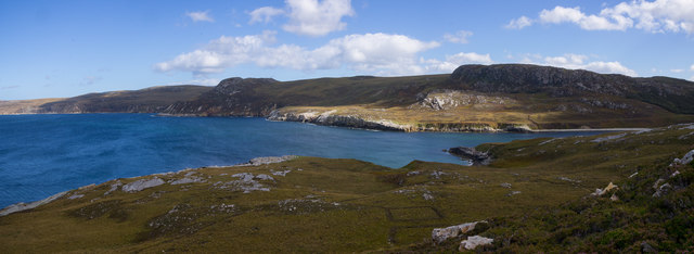
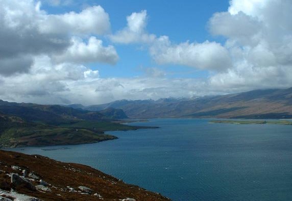
Geodha an t-Srathain is a coastal feature located in Sutherland, Scotland. It is a rugged and picturesque headland that juts out into the North Sea, offering stunning views of the surrounding landscape. The name "Geodha an t-Srathain" translates to "The Cove of the Stream" in English, reflecting the presence of a small stream that flows into the sea nearby.

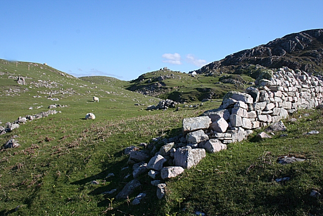
The headland is characterized by steep cliffs and rocky outcrops, with a mix of grassy slopes and heathland covering the area. Seabirds such as puffins, guillemots, and razorbills can often be spotted nesting on the cliffs, adding to the area's natural beauty and biodiversity.

Geodha an t-Srathain is a popular spot for hikers and wildlife enthusiasts, offering opportunities for coastal walks and birdwatching. The headland is also a great location for photography, with its dramatic seascapes and rugged terrain providing plenty of inspiration for nature lovers.

Overall, Geodha an t-Srathain is a stunning coastal feature that showcases the wild and unspoiled beauty of the Scottish coastline.

If you have any feedback on the listing, please let us know in the comments section below.

Geodha an t-Srathain Images

Images are sourced within 2km of 58.537468/-4.5946273 or Grid Reference NC4963. Thanks to Geograph Open Source API. All images are credited.

Shieling on the Moine The remains of a shieling hut, unmarked on the OS map. It is situated close to Allt Larach na h-Airigh, the name of which indicates that summer grazing took place at the location (Airigh = Shieling).
Shieling on the Moine
The remains of a shieling hut, unmarked on the OS map. It is situated close to Allt Larach na h-Airigh, the name of which indicates that summer grazing took place at the location (Airigh = Shieling).
A 'Mhoine The peatlands of the Moine, looking towards Ben Hutig.
A 'Mhoine
The peatlands of the Moine, looking towards Ben Hutig.
A' Mhoine Peatlands The Moine peatlands, looking towards the Southern slopes of Ben Hutig. This is an extensive area of blanket bog.
A' Mhoine Peatlands
The Moine peatlands, looking towards the Southern slopes of Ben Hutig. This is an extensive area of blanket bog.
A' Mhoine The Moine Peatlands, looking towards the Southern slopes of Ben Hutig. This is an extensive area of blanket bog.
A' Mhoine
The Moine Peatlands, looking towards the Southern slopes of Ben Hutig. This is an extensive area of blanket bog.
Quartzite scree on A' Mhoine The peninsula of the Moine is mainly covered by blanket bog, but weathered rock is exposed on the most exposed summits.
Quartzite scree on A' Mhoine
The peninsula of the Moine is mainly covered by blanket bog, but weathered rock is exposed on the most exposed summits.
West Slopes of Cnoc an Uillt Tharsuinn Mainly tussocky grass here which was difficult to walk over even in these dry conditions.
West Slopes of Cnoc an Uillt Tharsuinn
Mainly tussocky grass here which was difficult to walk over even in these dry conditions.
Alltan a' Choin Duibh The stream was little more than a ditch at this point. Cotton grass growing amongst the heather and tussocky grass.
Alltan a' Choin Duibh
The stream was little more than a ditch at this point. Cotton grass growing amongst the heather and tussocky grass.
Bouldery bed of Alltan a' Choin Duibh The burn drains the north part of A' Mhòine into Loch Eriboll.
Bouldery bed of Alltan a' Choin Duibh
The burn drains the north part of A' Mhòine into Loch Eriboll.
A low mound of drier turf near Allt Larach na h-Airigh A possible shieling site.
A low mound of drier turf near Allt Larach na h-Airigh
A possible shieling site.
A lone rowan by Allt Larach na h-Airigh
Mouth of the River Hope The River Hope is the main body of freshwater flowing into Loch Eriboll, and the large amount of sand carried into the sea shows up clearly below the surface on a sunny day.
Mouth of the River Hope
The River Hope is the main body of freshwater flowing into Loch Eriboll, and the large amount of sand carried into the sea shows up clearly below the surface on a sunny day.
Boulder debris from Creagh Ruadh cliffs
Cnoc nan Gobhar
Cnoc nan Gobhar
Valley of Allt an t-Srathain
Coast at Geodha an t-Srathain
Leathad a' Bhlair
Leathad a' Bhlair
Sgeir a' Bhuic from Cnoc nan Gobhar This island has hardly any vegetation and is obviously often mostly covered by water. The photo is taken from Cnoc nan Gobhar on the mainland.
Sgeir a' Bhuic from Cnoc nan Gobhar
This island has hardly any vegetation and is obviously often mostly covered by water. The photo is taken from Cnoc nan Gobhar on the mainland.
Coastline South of Geodha Raineach Square NC4864 consists almost entirely of sea, plus the group of small islands near the middle of the picture and (at low tide) a narrow piece of the shore to the North of them. In order to get to this square over land, you would have to descend and re-ascend the steep cliffs. This photo was taken from Cnoc nan Gobhar.
Coastline South of Geodha Raineach
Square NC4864 consists almost entirely of sea, plus the group of small islands near the middle of the picture and (at low tide) a narrow piece of the shore to the North of them. In order to get to this square over land, you would have to descend and re-ascend the steep cliffs. This photo was taken from Cnoc nan Gobhar.
Show me another place!

Geodha an t-Srathain is located at Grid Ref: NC4963 (Lat: 58.537468, Lng: -4.5946273)

Unitary Authority: Highland

Police Authority: Highlands and Islands

What 3 Words

///handbook.archduke.awestruck. Near Oldshoremore, Highland

Related Wikis

Ceannabeinne

Ceannabeinne (gaelic for the end of the mountains) is a ruined village within the parish of Durness, in the county of Sutherland, in the far north of the...

Sutherland spaceport

The Sutherland spaceport, also known as Space Hub Sutherland or UK Vertical Launch (UKVL) Sutherland, is a planned spaceport to be located in Sutherland...

A' Mhòine

A' Mhòine (Scottish Gaelic: [ә.ˈvɔːɲә]) is a peninsula in the Highlands, Scotland. The peninsula is bounded to the west by Loch Eriboll, and to the east...

Loch Eriboll

Loch Eriboll (Scottish Gaelic: "Loch Euraboil") is a 16 km (9.9 mi) long sea loch on the north coast of Scotland, which has been used for centuries as...

Nearby Amenities

Located within 500m of 58.537468,-4.5946273
Source: PGS
Lat/Long: 58.5419183/-4.594161
Source: PGS
Lat/Long: 58.5413005/-4.5943323
Source: PGS
Lat/Long: 58.541021/-4.5942847
Source: PGS
Lat/Long: 58.5408122/-4.5939942
Source: PGS
Lat/Long: 58.5402221/-4.5939408
Source: PGS
Lat/Long: 58.5399406/-4.5937408
Source: PGS
Lat/Long: 58.5394306/-4.5941526
Source: PGS
Lat/Long: 58.5391057/-4.5943624
Source: PGS
Lat/Long: 58.5386445/-4.5943038
Source: PGS
Lat/Long: 58.5379397/-4.5938176
Source: PGS
Lat/Long: 58.537615/-4.5940621
Source: PGS
Lat/Long: 58.5371593/-4.5946636
Source: PGS
Lat/Long: 58.5370142/-4.5946437
Source: PGS
Lat/Long: 58.5369909/-4.5950774
Source: PGS
Lat/Long: 58.5365924/-4.5951035
Source: PGS
Lat/Long: 58.5362171/-4.5948798
Source: PGS
Lat/Long: 58.5353705/-4.5940411
Source: PGS
Lat/Long: 58.5350714/-4.5936414
Source: PGS
Lat/Long: 58.535145/-4.5932867
Source: PGS
Lat/Long: 58.534207/-4.5940271
Source: PGS
Lat/Long: 58.5342876/-4.5953442
Source: PGS
Lat/Long: 58.5341594/-4.5956473
Source: PGS
Lat/Long: 58.5337961/-4.5960814
Source: PGS
Lat/Long: 58.5339231/-4.5966209
Source: PGS
Lat/Long: 58.5339699/-4.5971141
The data included in this document is from www.openstreetmap.org. The data is made available under ODbL.

Have you been to Geodha an t-Srathain?

Leave your review of Geodha an t-Srathain below (or comments, questions and feedback).