Blockan Hole

Coastal Feature, Headland, Point in Wigtownshire

Scotland

Blockan Hole

Path heading north-west through Physgill Glen The Physgill Glen descends from Kidsdale to the sea at Port Castle Bay.
Path heading north-west through Physgill Glen Credit: Trevor Littlewood

Blockan Hole is a prominent coastal feature located in Wigtownshire, Scotland. Situated along the western coast, it is specifically categorized as a headland or point due to its distinctive geological characteristics and its protrusion into the sea.

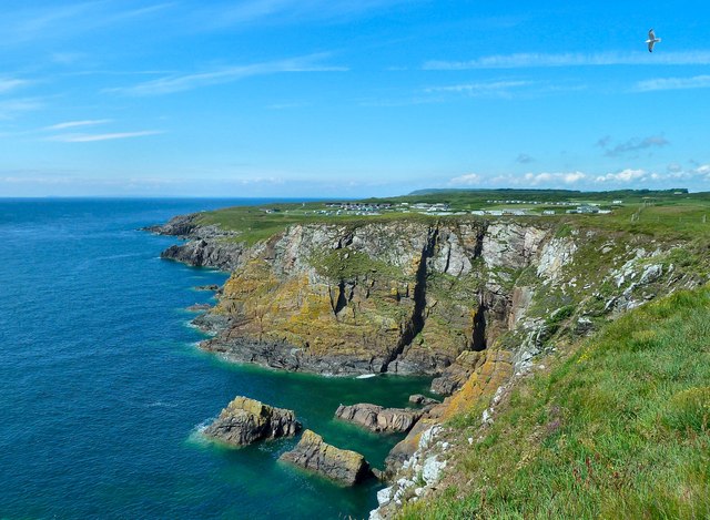
The headland of Blockan Hole is formed by a combination of sedimentary rocks, including sandstone and shale, which have been eroded over millions of years by the powerful forces of the ocean. This erosion has resulted in the creation of a rugged and dramatic coastline, with steep cliffs and rocky outcrops that provide a habitat for various marine and bird species.

The headland itself extends out into the sea, forming a natural barrier between the open waters and the adjacent coastline. This feature has played a significant role in coastal erosion prevention, as it helps to dissipate the energy of waves and protect the shoreline from excessive erosion.

Blockan Hole is renowned for its picturesque views and is a popular destination for nature enthusiasts and photographers. The headland offers panoramic vistas of the surrounding coastal landscape, with the vast expanse of the ocean stretching out into the horizon. The area is also known for its diverse range of flora and fauna, including rare plant species and nesting seabirds.

In addition to its natural beauty, Blockan Hole has historical significance. The headland has been inhabited by humans for thousands of years, with archaeological evidence suggesting the presence of ancient settlements and structures in the area. These remnants of human habitation serve as a testament to the long-standing relationship between people and the coastal environment.

If you have any feedback on the listing, please let us know in the comments section below.

Blockan Hole Images

Images are sourced within 2km of 54.682463/-4.4200261 or Grid Reference NX4434. Thanks to Geograph Open Source API. All images are credited.

Path heading north-west through Physgill Glen The Physgill Glen descends from Kidsdale to the sea at Port Castle Bay.
Path heading north-west through Physgill Glen
The Physgill Glen descends from Kidsdale to the sea at Port Castle Bay.
Old Boundary Marker near Burrow Head, Dumfries and Galloway War Department Boundary Marker on the cliff top northwest of Burrow Head Holiday Farm and 1000 metres south of Tonderghie. Formerly in Whithorn parish, Wigtownshire, now Dumfries and Galloway. It marks the boundary of Burrow Head heavy anti-aircraft practice battery and domestic site, see <span class="nowrap"><a title="https://canmore.org.uk/site/146537/burrow-head-heavy-anti-aircraft-practice-battery-and-domestic-site" rel="nofollow ugc noopener" href="https://canmore.org.uk/site/146537/burrow-head-heavy-anti-aircraft-practice-battery-and-domestic-site">Link</a><img style="margin-left:2px;" alt="External link" title="External link - shift click to open in new window" src="https://s1.geograph.org.uk/img/external.png" width="10" height="10"/></span>.

Milestone Society National ID: WT_WDWHIT01em
Old Boundary Marker near Burrow Head, Dumfries and Galloway
War Department Boundary Marker on the cliff top northwest of Burrow Head Holiday Farm and 1000 metres south of Tonderghie. Formerly in Whithorn parish, Wigtownshire, now Dumfries and Galloway. It marks the boundary of Burrow Head heavy anti-aircraft practice battery and domestic site, see LinkExternal link. Milestone Society National ID: WT_WDWHIT01em
Port Castle Bay, Whithorn This is the view down the beach from St. Ninian's Cave.
Port Castle Bay, Whithorn
This is the view down the beach from St. Ninian's Cave.
Valley of Bluebells This is the valley that takes the footpath down to the beach to St Ninian's Cave. Very stout footwear needed as is a muddy path and the beach to the cave is large round stones and difficult to walk
Valley of Bluebells
This is the valley that takes the footpath down to the beach to St Ninian's Cave. Very stout footwear needed as is a muddy path and the beach to the cave is large round stones and difficult to walk
Path to Port Castle Bay Track leading from Kidsdale to Port Castle Bay and St Ninian's Cave.
Path to Port Castle Bay
Track leading from Kidsdale to Port Castle Bay and St Ninian's Cave.
Coastal path, Burrow Head Looking west from close to Burrow Head.  The land visible in the distance is the Mull of Galloway.
Coastal path, Burrow Head
Looking west from close to Burrow Head. The land visible in the distance is the Mull of Galloway.
Stank Rocky promontory by the Burrow Head Holiday Farm, marked as Stank on the Explorer map.
Stank
Rocky promontory by the Burrow Head Holiday Farm, marked as Stank on the Explorer map.
Cutcloy Farm buildings at Cutcloy.
Cutcloy
Farm buildings at Cutcloy.
Cairn, Burrow Head Looking north from the high point of land at Burrow Head.  The lochan is not named.
Cairn, Burrow Head
Looking north from the high point of land at Burrow Head. The lochan is not named.
Ducker Craig Cleft on the left of scene is worked-out seam of Tonderghie copper mine (Mary Mine)
Ducker Craig
Cleft on the left of scene is worked-out seam of Tonderghie copper mine (Mary Mine)
View from St Ninian's cave
Tonderghie House Built C18 close to the coast west of Isle of Whithorn, Tonderghie is a harled laird’s house with main 4-storey block and single storey pavilion/garage; the gardens and house had C20 additions and alterations.
Tonderghie House
Built C18 close to the coast west of Isle of Whithorn, Tonderghie is a harled laird’s house with main 4-storey block and single storey pavilion/garage; the gardens and house had C20 additions and alterations.
High Arrow High Arrow Farm viewed from the Arbrack-Tonderghie lane near Isle of Whithorn.
High Arrow
High Arrow Farm viewed from the Arbrack-Tonderghie lane near Isle of Whithorn.
Burrowhead - Sea Cliffs To the west of the campsite at Burrowhead. There are the remains of war time gun emplacements and other buildings around this area.
Burrowhead - Sea Cliffs
To the west of the campsite at Burrowhead. There are the remains of war time gun emplacements and other buildings around this area.
Isle of Man from Burrow Head The outline of the Isle of Man can be made out amongst the clouds on the horizon. At night several different lighthouse beacons can be seen flashing.
Isle of Man from Burrow Head
The outline of the Isle of Man can be made out amongst the clouds on the horizon. At night several different lighthouse beacons can be seen flashing.
Clifftop path near Port Castle Bay One of the few stretches of discernible path along the cliffs of this part of Wigtownshire. Easy walking, but I did get in some trouble with the other half for riding a mountain bike along it, unaccompanied.
Clifftop path near Port Castle Bay
One of the few stretches of discernible path along the cliffs of this part of Wigtownshire. Easy walking, but I did get in some trouble with the other half for riding a mountain bike along it, unaccompanied.
Above Lobbocks The narrowness of the singletrack path, and the 120' cliff just 4' to the right, certainly help to concentrate the mind when riding this section!
Above Lobbocks
The narrowness of the singletrack path, and the 120' cliff just 4' to the right, certainly help to concentrate the mind when riding this section!
Lobbocks Yep - that is a correct spelling. Rock formations on the coast at the inlet of Lobbocks.
Lobbocks
Yep - that is a correct spelling. Rock formations on the coast at the inlet of Lobbocks.
Show me another place!

Blockan Hole is located at Grid Ref: NX4434 (Lat: 54.682463, Lng: -4.4200261)

Unitary Authority: Dumfries and Galloway

Police Authority: Dumfries and Galloway

What 3 Words

///obstinate.farmer.tramps. Near Whithorn, Dumfries & Galloway

Related Wikis

Burrow Head

Burrow Head is a headland located approximately two miles south-west of Isle of Whithorn, Wigtownshire, Scotland, and is the second southernmost point...

St Ninian's Cave

St Ninian's Cave is a cave in Physgill Glen, Whithorn, Dumfries and Galloway, Scotland. It features in the climax of the acclaimed 1973 horror film The...

Isle of Whithorn

Isle of Whithorn (Port Rosnait in Gaelic) is one of the most southerly villages and seaports in Scotland, lying on the coast north east of Burrow Head...

Glasserton

Glasserton is a civil parish in Dumfries and Galloway, south-west Scotland. It is on the Machars peninsula, in the traditional county of Wigtownshire....

Nearby Amenities

Located within 500m of 54.682463,-4.4200261
Source: PGS
Lat/Long: 54.6850375/-4.4261584
Source: PGS
Lat/Long: 54.6848142/-4.4256863
Source: PGS
Lat/Long: 54.6846777/-4.4251714
Source: PGS
Lat/Long: 54.684584/-4.424558
Source: PGS
Lat/Long: 54.6844173/-4.4240985
Source: PGS
Lat/Long: 54.684256/-4.4236479
Source: PGS
Lat/Long: 54.6841071/-4.4230041
Source: PGS
Lat/Long: 54.6835365/-4.4237122
Source: PGS
Lat/Long: 54.6833257/-4.4232402
Source: PGS
Lat/Long: 54.683066/-4.422958
Source: PGS
Lat/Long: 54.682807/-4.423169
Source: PGS
Lat/Long: 54.682689/-4.422281
Source: PGS
Lat/Long: 54.682592/-4.419625
Source: PGS
Lat/Long: 54.681824/-4.419598
Source: PGS
Lat/Long: 54.681711/-4.418268
Source: PGS
Lat/Long: 54.681466/-4.417375
Source: PGS
Lat/Long: 54.681341/-4.417151
Source: PGS
Lat/Long: 54.680831/-4.416911
Source: PGS
Lat/Long: 54.680964/-4.416474
Source: PGS
Lat/Long: 54.681225/-4.416041
Source: PGS
Lat/Long: 54.681359/-4.415603
Source: PGS
Lat/Long: 54.680844/-4.415807
Source: PGS
Lat/Long: 54.680585/-4.416018
Source: PGS
Lat/Long: 54.680483/-4.413805
The data included in this document is from www.openstreetmap.org. The data is made available under ODbL.

Have you been to Blockan Hole?

Leave your review of Blockan Hole below (or comments, questions and feedback).