Battery Point

Coastal Feature, Headland, Point in Devon

England

Battery Point

Quarter Wall Cottages – Lundy Island, Devon These are the Quarter Wall Cottages which were built to house the quarrymen employed by the Lundy Granite Company. Their working conditions may have been harsh – hard manual work in a very raw and exposed environment. There are still signs of the old Lundy Railway, built to transport the granite to waiting ships and away from the island. Time photo taken not available.
Quarter Wall Cottages – Lundy Island, Devon Credit: Martin Richard Phelan

Battery Point is a prominent coastal feature located in Devon, England. It is a headland that stretches out into the sea, forming a distinctive point. With its strategic position overlooking the water, Battery Point has played an important role in the maritime history of the region.

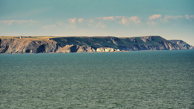
The headland is known for its rugged beauty and is a popular destination for locals and tourists alike. Its unique geological formation is characterized by sheer cliffs that drop dramatically into the sea. The point offers breathtaking views of the surrounding coastline, making it a favored spot for photographers and nature enthusiasts.

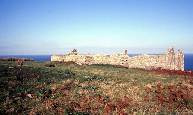
Battery Point gets its name from the historic fortifications that once stood on its grounds. These defensive structures were built in the 19th century to protect the coast from potential invasions. While the fortifications are no longer in use, their remnants can still be seen, adding an intriguing historical element to the site.

The area surrounding Battery Point is rich in biodiversity, making it a haven for wildlife. Seabirds such as gulls, cormorants, and puffins can often be spotted nesting on the cliffs, while seals and dolphins can occasionally be seen swimming in the waters below.

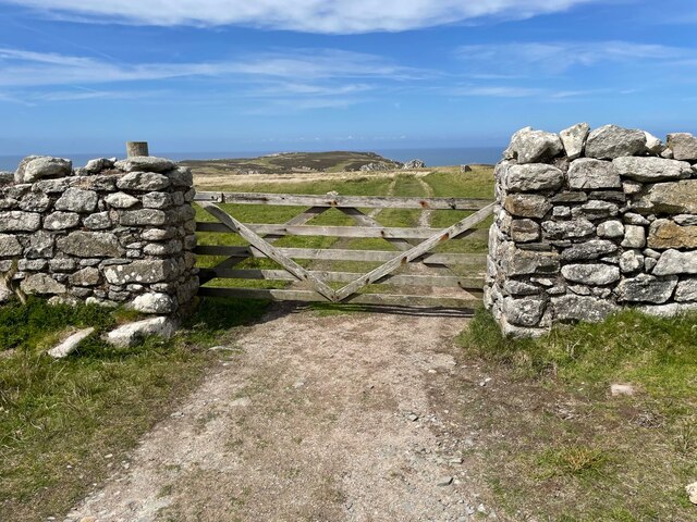
Access to Battery Point is relatively easy, with a footpath leading from the nearby town. The headland is a popular location for coastal walks, providing visitors with the opportunity to explore the rugged terrain and immerse themselves in the natural beauty of the area.

Overall, Battery Point is a stunning coastal feature that offers a blend of natural beauty and historical significance. Its unique geological formations, historical fortifications, and abundant wildlife make it a must-visit destination for anyone exploring the Devon coastline.

If you have any feedback on the listing, please let us know in the comments section below.

Battery Point Images

Images are sourced within 2km of 51.172251/-4.6808184 or Grid Reference SS1244. Thanks to Geograph Open Source API. All images are credited.

Quarter Wall Cottages – Lundy Island, Devon These are the Quarter Wall Cottages which were built to house the quarrymen employed by the Lundy Granite Company. Their working conditions may have been harsh – hard manual work in a very raw and exposed environment. There are still signs of the old Lundy Railway, built to transport the granite to waiting ships and away from the island. Time photo taken not available.
Quarter Wall Cottages – Lundy Island, Devon
These are the Quarter Wall Cottages which were built to house the quarrymen employed by the Lundy Granite Company. Their working conditions may have been harsh – hard manual work in a very raw and exposed environment. There are still signs of the old Lundy Railway, built to transport the granite to waiting ships and away from the island. Time photo taken not available.
THV Galatea at work off Lundy Island This Trinity House vessel was busy with lighthouse work that involved a helicopter going back and forth. For more about the Galatea see <span class="nowrap"><a title="https://trinityhouse.co.uk/commercial-services/our-services/vessel-hire/thv-galatea" rel="nofollow ugc noopener" href="https://trinityhouse.co.uk/commercial-services/our-services/vessel-hire/thv-galatea">Link</a><img style="margin-left:2px;" alt="External link" title="External link - shift click to open in new window" src="https://s1.geograph.org.uk/img/external.png" width="10" height="10"/></span>
THV Galatea at work off Lundy Island
This Trinity House vessel was busy with lighthouse work that involved a helicopter going back and forth. For more about the Galatea see LinkExternal link
Gateway in Threequarter Wall, Lundy Gateway on a track leading to the north end of Lundy.
Gateway in Threequarter Wall, Lundy
Gateway on a track leading to the north end of Lundy.
'Beach Road', Lundy Island
The eastern cliffs of Lundy Island
Millcombe House, Lundy Island
Holiday rental properties on Lundy Island
The only tree in the village? A rarity on Lundy Island, in the garden of 'Old House'.
The only tree in the village?
A rarity on Lundy Island, in the garden of 'Old House'.
The Marisco Tavern, Lundy Island
The shop and store on Lundy
Looking back to the mainland
Track heading to the north of Lundy Island
St Helen's Church, Lundy Island
Interior, St Helen's Church, Lundy Island
View towards the 'Old Light' on Lundy
Sailing ship, anchored off Lundy
Track towards Marisco Castle
The Southern Coast of Lundy Approaching the island of Lundy from the south.

Lundy is the largest island in the Bristol Channel, three miles long and half a mile wide. It lies 10 nautical miles off the coast of North Devon, about a third of the distance across the channel from Devon to Pembrokeshire in Wales.

Lundy was donated to the National Trust in 1969 and is managed by the Landmark Trust.
The Southern Coast of Lundy
Approaching the island of Lundy from the south. Lundy is the largest island in the Bristol Channel, three miles long and half a mile wide. It lies 10 nautical miles off the coast of North Devon, about a third of the distance across the channel from Devon to Pembrokeshire in Wales. Lundy was donated to the National Trust in 1969 and is managed by the Landmark Trust.
Show me another place!

Battery Point is located at Grid Ref: SS1244 (Lat: 51.172251, Lng: -4.6808184)

Administrative County: Devon

Police Authority: Devon and Cornwall

What 3 Words

///undivided.heartened.says. Near Northam, Devon

Related Wikis

Jenny (1783 ship)

Jenny was built at Newfoundland in 1783. She sailed to Britain and traded between Britain and Newfoundland and then between Bristol and Africa until 1790...

Lundy

Lundy is an English island in the Bristol Channel. It forms part of the district of Torridge in the county of Devon. About 3 miles (5 kilometres) long...

St Helen's Church, Lundy

Saint Helen's Church, also often incorrectly known as Saint Helena's Church, is an Anglican church on the 445 ha (1,100 acres) island of Lundy, lying at...

Nearby Amenities

Located within 500m of 51.172251,-4.6808184
Source: PGS
Lat/Long: 51.1696133/-4.6776051
Source: PGS
Lat/Long: 51.1750829/-4.6803332
Barrier: stile
Lat/Long: 51.1739356/-4.6765088
The Battery
Historic: ruins
Lat/Long: 51.1722845/-4.6799998
Cannon
Historic: cannon
Lat/Long: 51.1723973/-4.6799866
Dead Cow Point
Place: locality
Lat/Long: 51.1752888/-4.6804853
The data included in this document is from www.openstreetmap.org. The data is made available under ODbL.

Have you been to Battery Point?

Leave your review of Battery Point below (or comments, questions and feedback).