Black Hole

Coastal Feature, Headland, Point in Wigtownshire

Scotland

Black Hole

Portpatrick From the coast path to the north west, the start of the Southern Upland Way to Cockburnspath on the east coast.
Portpatrick Credit: Andy Stephenson

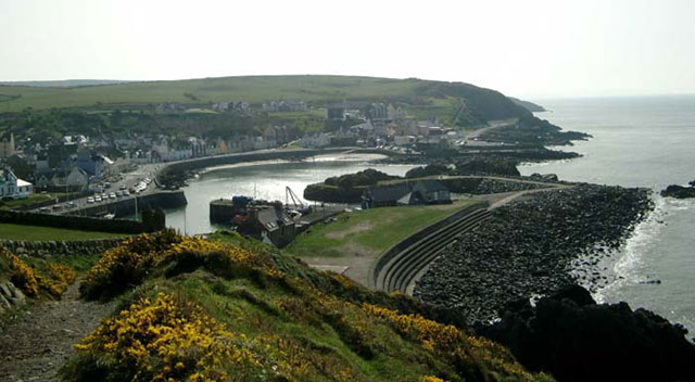
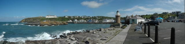
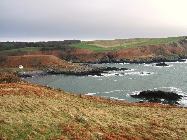
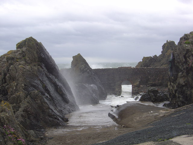
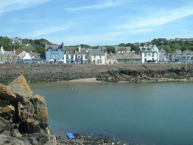
Black Hole is a prominent coastal feature located in Wigtownshire, Scotland. It is classified as a headland or a point, jutting out into the Irish Sea. The name "Black Hole" is derived from the dark and mysterious appearance of the area, which is surrounded by steep cliffs and rocky terrain.

At Black Hole, the rugged coastline is characterized by its distinctive geological formations. The headland is composed of layers of sandstone and shale, giving it a unique texture and color. The rocks here have been shaped by the relentless power of the ocean, resulting in dramatic cliff faces and natural arches.

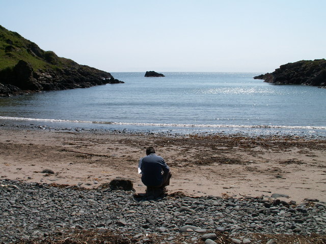
The area is also known for its rich biodiversity. Black Hole provides a habitat for a variety of plant and animal species, including seabirds, marine mammals, and coastal vegetation. The headland's cliffs offer nesting sites for seabird colonies, such as guillemots, razorbills, and kittiwakes. Visitors can observe these fascinating creatures in their natural habitat, making Black Hole a popular destination for birdwatchers and nature enthusiasts.

In addition to its ecological significance, Black Hole holds historical and cultural importance. The headland has witnessed centuries of human activity, with evidence of ancient settlements and ruins of an old fort. These remnants serve as a reminder of the area's rich heritage and provide a glimpse into the lives of past inhabitants.

Overall, Black Hole in Wigtownshire is a captivating coastal feature that combines natural beauty, ecological diversity, and historical significance. Its stunning cliffs, unique geology, and abundant wildlife make it a must-visit destination for those seeking to explore Scotland's coastal treasures.

If you have any feedback on the listing, please let us know in the comments section below.

Black Hole Images

Images are sourced within 2km of 54.837672/-5.1144327 or Grid Reference NX0053. Thanks to Geograph Open Source API. All images are credited.
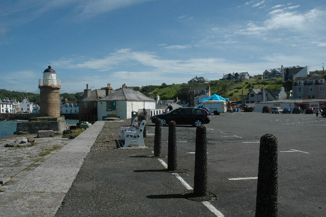
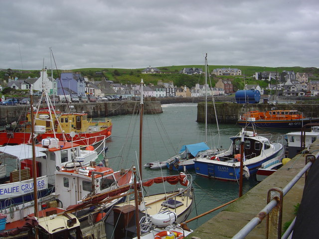
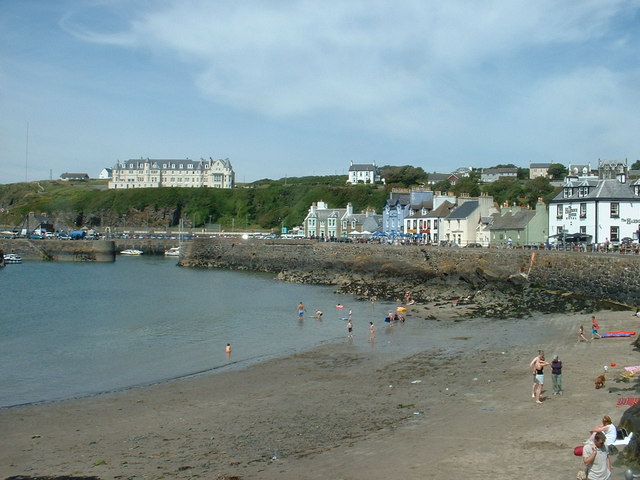
Portpatrick From the coast path to the north west, the start of the Southern Upland Way to Cockburnspath on the east coast.
Portpatrick
From the coast path to the north west, the start of the Southern Upland Way to Cockburnspath on the east coast.
Dunskey Glen, near Portpatrick
A tribute to the Lifeboatmen of Portpatrick This is in memory of the Lifeboatmen of Portpatrick who, in January 1953, risked their lives to save the passengers and crew of the BR/S Princess Victoria during The Great Storm.
A tribute to the Lifeboatmen of Portpatrick
This is in memory of the Lifeboatmen of Portpatrick who, in January 1953, risked their lives to save the passengers and crew of the BR/S Princess Victoria during The Great Storm.
Car park at south end of Portpatrick Harbour Car park at south end of Portpatrick Harbour.
Car park at south end of Portpatrick Harbour
Car park at south end of Portpatrick Harbour.
Portpatrick This is a panoramic view on Portpatrick. Four pictures were used for this view and were stitched together using Panavue.
Portpatrick
This is a panoramic view on Portpatrick. Four pictures were used for this view and were stitched together using Panavue.
Port Kale and Port Mora Bays from Catebraid near Portpatrick Port Kale (foreground) and Port Mora (known locally as Sandeel Bay) Bays near Portpatrick. This location covers three ordnance survey squares but I have chosen the furthest away for the location.
Port Kale and Port Mora Bays from Catebraid near Portpatrick
Port Kale (foreground) and Port Mora (known locally as Sandeel Bay) Bays near Portpatrick. This location covers three ordnance survey squares but I have chosen the furthest away for the location.
A waterfall over caves at the end of Sandeel Bay (Port Mora Bay) near Portpatrick.
Port Patrick Hotel Taken from the old Harbour in Portpatrick up towards the hotel
Port Patrick Hotel
Taken from the old Harbour in Portpatrick up towards the hotel
Portpatrick Harbour My yacht 'Makushla' is the large yacht moored against the wall with the smaller one rafted against it.
Portpatrick Harbour
My yacht 'Makushla' is the large yacht moored against the wall with the smaller one rafted against it.
Portpatrick Waterfront Hotel
Portpatrick Harbour
Portpatrick Harbour
View from Portpatrick
Port Mora
Port Mora
The Portpatrick Hotel The hotel in the picture dominates the village of Portpatrick, and is The Portpatrick Hotel. It is late Victorian and is now owned by the Wallace Arnold Shearings Group.
The Portpatrick Hotel
The hotel in the picture dominates the village of Portpatrick, and is The Portpatrick Hotel. It is late Victorian and is now owned by the Wallace Arnold Shearings Group.
Portpatrick waterfront
The south side of Portpatrick Harbour
The Inner Harbour breakwater The breakwater connects the mainland [visible right] with a natural rock islet in the harbour, creating a totally sheltered 'arm' of the harbour.
The Inner Harbour breakwater
The breakwater connects the mainland [visible right] with a natural rock islet in the harbour, creating a totally sheltered 'arm' of the harbour.
Portpatrick waterfront, looking north And there's that hotel again, overlooking everything.....
Portpatrick waterfront, looking north
And there's that hotel again, overlooking everything.....
Show me another place!

Black Hole is located at Grid Ref: NX0053 (Lat: 54.837672, Lng: -5.1144327)

Unitary Authority: Dumfries and Galloway

Police Authority: Dumfries and Galloway

What 3 Words

///arrow.minder.grounding. Near Stranraer, Dumfries & Galloway

Related Wikis

Dunskey

Dunskey Estate (also known as Portree Estate) is north of Portpatrick on the west coast of Scotland. The B-listed mansion dates from the start of the twentieth...

Dunskey Castle

Dunskey Castle is a ruined, 12th-century tower house or castle, located 0.5 miles (0.80 km) south of the village of Portpatrick, Rhinns, Wigtownshire,...

Portpatrick railway station

Portpatrick railway station was a railway station serving the village of Portpatrick, Dumfries & Galloway, Scotland. Opened in 1862 the station served...

Portpatrick

Portpatrick is a village and civil parish in the historical county of Wigtownshire, Dumfries and Galloway, Scotland. It is located on the west coast of...

Nearby Amenities

Located within 500m of 54.837672,-5.1144327
Source: PGS
Lat/Long: 54.841046/-5.1193526
Source: PGS
Lat/Long: 54.8410258/-5.1191646
Source: PGS
Lat/Long: 54.8409511/-5.1191095
Source: PGS
Lat/Long: 54.8411353/-5.1188084
Source: PGS
Lat/Long: 54.8413937/-5.1187667
Source: PGS
Lat/Long: 54.8417344/-5.1169749
Source: PGS
Lat/Long: 54.8414456/-5.1167172
Source: PGS
Lat/Long: 54.8409668/-5.116658
Source: PGS
Lat/Long: 54.8406612/-5.1170131
Source: PGS
Lat/Long: 54.840683/-5.1174969
Source: PGS
Lat/Long: 54.8404308/-5.1181179
Source: PGS
Lat/Long: 54.8400057/-5.1181282
Source: PGS
Lat/Long: 54.8399316/-5.117817
Source: PGS
Lat/Long: 54.8398327/-5.1175381
Source: PGS
Lat/Long: 54.8397401/-5.1173342
Source: PGS
Lat/Long: 54.8386897/-5.1170016
Source: PGS
Lat/Long: 54.8388133/-5.1165832
Source: PGS
Lat/Long: 54.8388689/-5.1163472
Source: PGS
Lat/Long: 54.8385476/-5.1162506
Created By: dmgroom_coastlines
Source: PGS
Lat/Long: 54.838182/-5.115887
Created By: dmgroom_coastlines
Source: PGS
Lat/Long: 54.838057/-5.115658
Created By: dmgroom_coastlines
Source: PGS
Lat/Long: 54.837934/-5.115431
Created By: dmgroom_coastlines
Source: PGS
Lat/Long: 54.837429/-5.11496
Created By: dmgroom_coastlines
Source: PGS
Lat/Long: 54.837305/-5.114731
Created By: dmgroom_coastlines
Source: PGS
Lat/Long: 54.837064/-5.113831
Created By: dmgroom_coastlines
Source: PGS
Lat/Long: 54.836941/-5.113603
Created By: dmgroom_coastlines
Source: PGS
Lat/Long: 54.836816/-5.113374
Created By: dmgroom_coastlines
Source: PGS
Lat/Long: 54.836692/-5.113146
Created By: dmgroom_coastlines
Source: PGS
Lat/Long: 54.836184/-5.112897
Created By: dmgroom_coastlines
Source: PGS
Lat/Long: 54.836071/-5.112004
Created By: dmgroom_coastlines
Source: PGS
Lat/Long: 54.835959/-5.11111
Created By: dmgroom_coastlines
Source: PGS
Lat/Long: 54.834939/-5.110836
Created By: dmgroom_coastlines
Source: PGS
Lat/Long: 54.834431/-5.110587
Created By: dmgroom_coastlines
Source: PGS
Lat/Long: 54.834567/-5.11015
Portpatrick
Name En: Portpatrick
Name Gd: Port Phàdraig
Place: village
Lat/Long: 54.8418486/-5.1168367
Bus Stop
South Crescent
Naptan AtcoCode: 680000277111
Naptan Bearing: N
Naptan CommonName: South Crescent
Naptan Indicator: opp 15
Naptan Landmark: Harbour
Naptan NaptanCode: 34234876
Naptan Notes: none
Naptan Street: South Crescent
Naptan Verified: yes
Shelter: no
Source: naptan_import
Lat/Long: 54.8411332/-5.116445
Post Box
Check Date Collection Times: 2022-04-12
Collection Times: Mo-Fr 15:15; Sa 11:30
Operator: Royal Mail
Operator Wikidata: Q638098
Post Box Type: wall
Ref: DG9 34
Royal Cypher: GR
Royal Cypher Wikidata: Q33102273
Lat/Long: 54.8408155/-5.1161228
Restaurant
Connor’s Restaurant
Addr City: Portpatrick
Addr Housename: Connor’s Restaurant
Addr Housenumber: 1
Addr Postcode: DG9 8JR
Addr Street: South Crescent
Check Date: 2023-08-08
Contact Facebook: https://www.facebook.com/people/Connors-Restaurant/100038148437235/
Email: Info@connorsrestaurant.co.uk
Opening Hours: Su-Tu 12:30-19:45; Fr-Sa 12:30-20:45
Outdoor Seating: yes
Phone: +44 1776 810314
Source: https://www.dgfoodanddrink.com/outlet/connors-restaurant/
Lat/Long: 54.840443/-5.1166258
Seamark Light Category: lower
Seamark Light Character: F
Seamark Light Colour: green
Seamark Light Reference: A 4607
Seamark Status: occasional
Seamark Type: light_minor
Source: US NGA Pub. 114. 2011-05-26.
Lat/Long: 54.8418/-5.1168833
Lighthouse Pottery
Addr City: Portpatrick
Addr Housename: Old Lighthouse
Addr Postcode: DG9 8LE
Check Date: 2023-08-08
Phone: +44 1776 810284
Shop: gift
Website: https://lighthouse-pottery.business.site/
Lat/Long: 54.8405276/-5.1175974
Tourism: viewpoint
Lat/Long: 54.8412469/-5.1191035
Cafe
The Boardwalk
Addr City: Portpatrick
Addr Housename: The Boardwalk
Addr Street: South Crescent
Check Date: 2023-08-08
Contact Facebook: https://www.facebook.com/BoardWalk1234/
Delivery: yes
Opening Hours: Su-Th 12:00-18:30; Fr-Sa 12:00-20:30
Outdoor Seating: yes
Payment Cash: yes
Payment Credit Cards: yes
Phone: +44 1776 810969
Source: https://restaurantguru.com/The-Boardwalk-Portpatrick
Takeaway: yes
Lat/Long: 54.8402539/-5.1168196
Man Made: lighthouse
Lat/Long: 54.8405641/-5.1177943
John Gillespie & Son
Shop: convenience
Lat/Long: 54.8419546/-5.1161918
Give Way
Direction: forward
Lat/Long: 54.8418099/-5.1168099
Bench
Lat/Long: 54.8404315/-5.1170342
Bench
Lat/Long: 54.8408775/-5.1163059
Bench
Lat/Long: 54.8409143/-5.1163081
Bench
Lat/Long: 54.8396487/-5.1165684
Bench
Lat/Long: 54.8396537/-5.1163753
Bench
Lat/Long: 54.8393598/-5.1164382
Bench
Lat/Long: 54.8412965/-5.1164992
Bench
Lat/Long: 54.8414192/-5.1165651
Bench
Lat/Long: 54.8415122/-5.1166247
Bench
Lat/Long: 54.8416063/-5.1166987
Bench
Lat/Long: 54.8418329/-5.1171103
The Attic Portpatrick
Addr City: Portpatrick
Addr Housename: The Attic Portpatrick
Addr Housenumber: 11a
Addr Postcode: DG9 8JU
Addr Street: Colonel Street
Check Date: 2023-08-09
Dog: yes
Internet Access: wlan
Pets: yes
Rooms: 2
Tourism: apartment
Website: https://www.atticportpatrick.co.uk/
Lat/Long: 54.8414933/-5.1155762
The data included in this document is from www.openstreetmap.org. The data is made available under ODbL.

Have you been to Black Hole?

Leave your review of Black Hole below (or comments, questions and feedback).