Bloody Rock

Coastal Feature, Headland, Point in Wigtownshire

Scotland

Bloody Rock

Corsewall Lighthouse Copious amounts of Sea Thrift (Armeria maritima) grow here.
Corsewall Lighthouse Credit: Jon Alexander

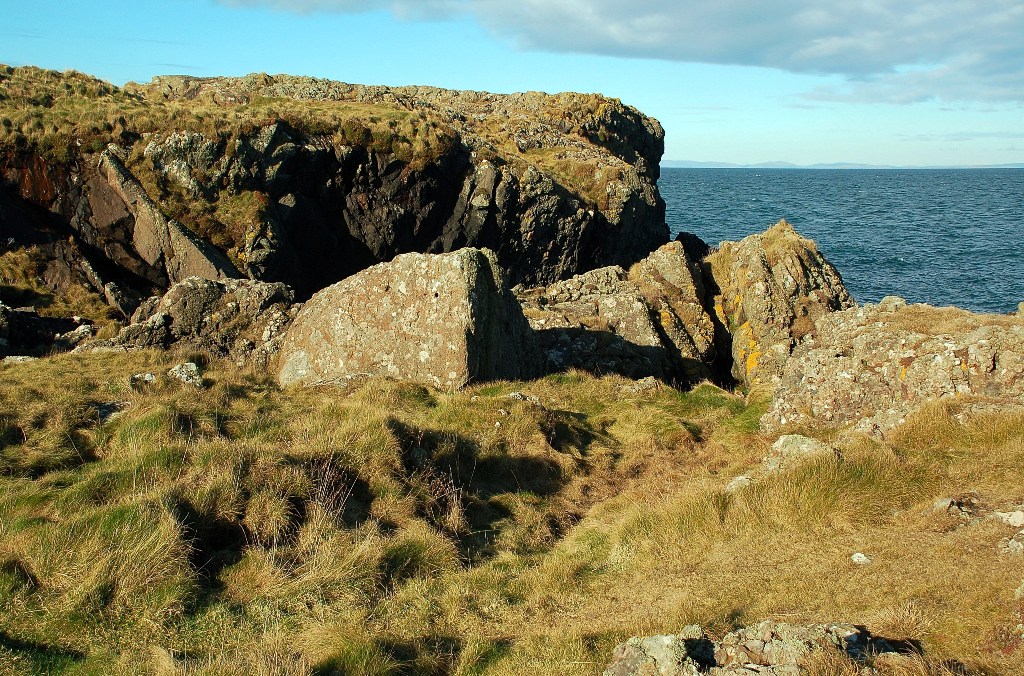
Bloody Rock is a prominent headland located in Wigtownshire, a region in southwestern Scotland. Positioned along the rugged coastline, this coastal feature is known for its distinctive red-colored rock formations, which give it its unique name. The headland juts out into the North Channel, offering breathtaking views of the Irish Sea and the surrounding landscape.

Standing at an elevation of approximately 100 meters, Bloody Rock provides a commanding presence along the shoreline. Its towering cliffs, composed of sandstone and limestone, are heavily weathered and eroded, showcasing the power of the relentless crashing waves over time. These cliffs are home to a variety of seabirds, including gulls, kittiwakes, and fulmars, which can often be seen nesting and soaring above the turbulent waters.

The headland is accessible via a well-maintained footpath that winds its way up from the nearby coastal village, offering visitors a chance to explore the unique geological features and enjoy panoramic views of the surrounding area. The path is relatively easy to navigate, but caution is advised as the cliffs can be steep and slippery.

Bloody Rock is a popular destination for hikers, nature enthusiasts, and photographers due to its dramatic scenery and abundant wildlife. The juxtaposition of the red rocks against the deep blue sea creates a striking visual contrast, making it a favored spot for capturing stunning photographs. Whether exploring the headland's rugged terrain, observing the diverse birdlife, or simply admiring the natural beauty, Bloody Rock is a captivating coastal feature that leaves a lasting impression on all who visit.

If you have any feedback on the listing, please let us know in the comments section below.

Bloody Rock Images

Images are sourced within 2km of 54.998487/-5.1688039 or Grid Reference NW9771. Thanks to Geograph Open Source API. All images are credited.

Corsewall Lighthouse Copious amounts of Sea Thrift (Armeria maritima) grow here.
Corsewall Lighthouse
Copious amounts of Sea Thrift (Armeria maritima) grow here.
Rock Art Somebody has a sense of humour!
Rock Art
Somebody has a sense of humour!
Meadow Pipit (Anthus pratensis) It was very tame and just waited for me to move away from its dinner.
Meadow Pipit (Anthus pratensis)
It was very tame and just waited for me to move away from its dinner.
Leaving Loch Ryan Stena Superfast VIII heading from Cairnryan to Belfast, passing through NX9873 off Corsewall Point.
Leaving Loch Ryan
Stena Superfast VIII heading from Cairnryan to Belfast, passing through NX9873 off Corsewall Point.
Corsewall Point lighthouse After being automated, the lighthouse buildings are now used for a hotel and restaurant.
Corsewall Point lighthouse
After being automated, the lighthouse buildings are now used for a hotel and restaurant.
Ailsa Craig view This view looks towards the high cliffs on the south side of the island.
Ailsa Craig view
This view looks towards the high cliffs on the south side of the island.
Corsewall Point lighthouse From the ferry to Larne.
Corsewall Point lighthouse
From the ferry to Larne.
Stena Line Ferry passing the Corsewall Lighthouse Viewed from the P&O European Causeway ferry headed for Cairnryan.
Stena Line Ferry passing the Corsewall Lighthouse
Viewed from the P&O European Causeway ferry headed for Cairnryan.
Corsewall Lighthouse
North Cairn Farm Kirkcolm The view of North Cairn farmhouse, over the hill behind are views of the Northern Ireland coastline.
North Cairn Farm Kirkcolm
The view of North Cairn farmhouse, over the hill behind are views of the Northern Ireland coastline.
Corsewall Lighthouse from Cairnside Farm View from Cairnside Farm to Corsewall Lighthouse.
Corsewall Lighthouse from Cairnside Farm
View from Cairnside Farm to Corsewall Lighthouse.
Corsewall Lighthouse View of Corsewall Lighthouse from a passing Larne to Cairnrayn ferry
Corsewall Lighthouse
View of Corsewall Lighthouse from a passing Larne to Cairnrayn ferry
Corsewall Lighthouse Corsewall Lighthouse, image made from an inbound ferry approaching Loch Ryan.
Corsewall Lighthouse
Corsewall Lighthouse, image made from an inbound ferry approaching Loch Ryan.
Pigs and Arks Barnhills Farm.
Pigs and Arks
Barnhills Farm.
Cairnside Farm, The Rhins Ireland on the horizon.
Cairnside Farm, The Rhins
Ireland on the horizon.
Cairnside Farm, The Rhins Kintyre on the horizon.
Cairnside Farm, The Rhins
Kintyre on the horizon.
North Cairn Farm, The Rhins
Corsewall Hotel, The Rhins As you can see formerly a lighthouse.
Corsewall Hotel, The Rhins
As you can see formerly a lighthouse.
Show me another place!

Bloody Rock is located at Grid Ref: NW9771 (Lat: 54.998487, Lng: -5.1688039)

Unitary Authority: Dumfries and Galloway

Police Authority: Dumfries and Galloway

What 3 Words

///spice.projects.segregate. Near Cairnryan, Dumfries & Galloway

Related Wikis

Corsewall Point

Corsewall Point, or Corsill Point, is a headland at the northern end of the Rhins of Galloway in Scotland. A lighthouse, Corsewall Lighthouse, was placed...

Ervie

Ervie is a small village in Dumfries and Galloway, Scotland, in the Rhins of Galloway, just outside Stranraer.

Kirkcolm

Kirkcolm (Scots: Kirkcoam) is a village and civil parish on the northern tip of the Rhinns of Galloway peninsula, south-west Scotland. It is in Dumfries...

RAF Wig Bay

Royal Air Force Wig Bay, or more simply RAF Wig Bay, is a former Royal Air Force station near Stranraer, Dumfries and Galloway, Scotland The following...

Nearby Amenities

Located within 500m of 54.998487,-5.1688039
Created By: dmgroom_coastlines
Source: PGS
Lat/Long: 55.001921/-5.164385
Created By: dmgroom_coastlines
Source: PGS
Lat/Long: 55.001777/-5.165269
Created By: dmgroom_coastlines
Source: PGS
Lat/Long: 55.001525/-5.165033
Source: PGS
Lat/Long: 55.0014863/-5.1655576
Source: PGS
Lat/Long: 55.0015103/-5.166667
Created By: dmgroom_coastlines
Source: PGS
Lat/Long: 55.001234/-5.167022
Created By: dmgroom_coastlines
Source: PGS
Lat/Long: 55.000466/-5.166981
Source: PGS
Lat/Long: 55.0008482/-5.1675543
Created By: dmgroom_coastlines
Source: PGS
Lat/Long: 55.000186/-5.168303
Created By: dmgroom_coastlines
Source: PGS
Lat/Long: 54.999678/-5.168053
Created By: dmgroom_coastlines
Source: PGS
Lat/Long: 54.999422/-5.16804
Created By: dmgroom_coastlines
Source: PGS
Lat/Long: 54.998647/-5.168443
Created By: dmgroom_coastlines
Source: PGS
Lat/Long: 54.997363/-5.168596
Source: PGS
Lat/Long: 54.9978605/-5.1694855
Created By: dmgroom_coastlines
Source: PGS
Lat/Long: 54.997211/-5.169925
Created By: dmgroom_coastlines
Source: PGS
Lat/Long: 54.997203/-5.17037
Created By: dmgroom_coastlines
Source: PGS
Lat/Long: 54.997067/-5.170808
Created By: dmgroom_coastlines
Source: PGS
Lat/Long: 54.99656/-5.170559
Created By: dmgroom_coastlines
Source: PGS
Lat/Long: 54.996304/-5.170545
Created By: dmgroom_coastlines
Source: PGS
Lat/Long: 54.99604/-5.170976
Created By: dmgroom_coastlines
Source: PGS
Lat/Long: 54.995524/-5.17117
Source: PGS
Lat/Long: 54.9960068/-5.1718919
Created By: dmgroom_coastlines
Source: PGS
Lat/Long: 54.995236/-5.172937
Created By: dmgroom_coastlines
Source: PGS
Lat/Long: 54.994984/-5.172702
The data included in this document is from www.openstreetmap.org. The data is made available under ODbL.

Have you been to Bloody Rock?

Leave your review of Bloody Rock below (or comments, questions and feedback).