Dark Hole

Coastal Feature, Headland, Point in Cornwall

England

Dark Hole

Rickyard of Pentire Farm near Padstow, 1952 This triangular area was used as a rickyard until the National Trust acquired the farm, made this area a car park, made the farmhouse a holiday let, and employed contractors to do the farming. The car in the photo is a 1934 Ford V8.
Rickyard of Pentire Farm near Padstow, 1952 Credit: David Hawgood

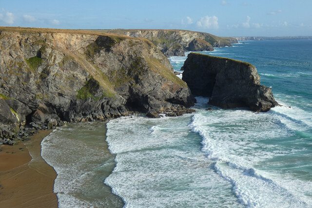
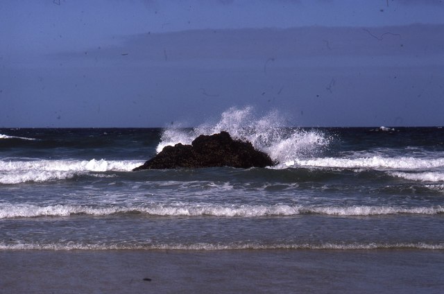
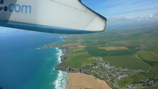
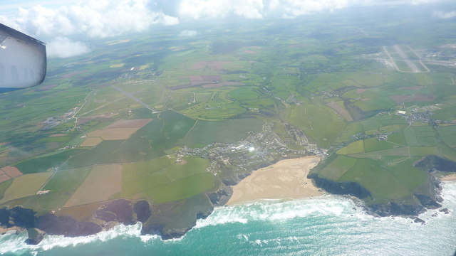
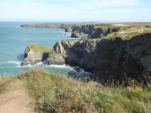
Dark Hole is a stunning coastal feature located in Cornwall, England. Situated on the southwestern tip of the county, it is renowned for its dramatic cliffs, pristine beaches, and picturesque landscapes. Dark Hole is specifically categorized as a headland, a prominent and elevated area of land that extends into the sea.

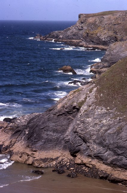
The headland of Dark Hole is characterized by its rugged and jagged cliffs, which soar high above the crashing waves of the Atlantic Ocean. The cliffs are composed of dark-colored rocks, giving the area its distinct name. These cliffs provide a breathtaking vantage point, offering panoramic views of the surrounding coastline and the vast expanse of the ocean.

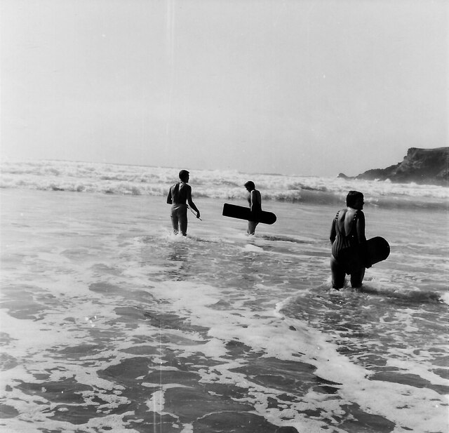
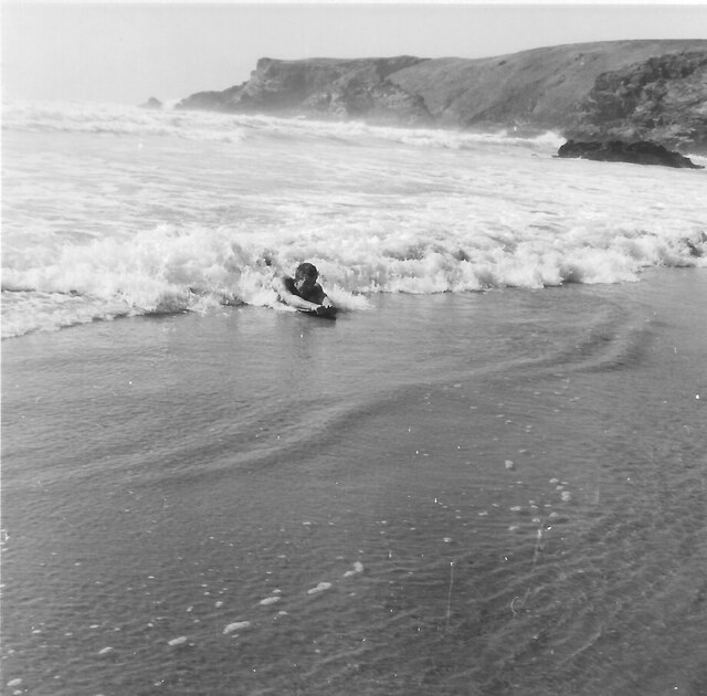
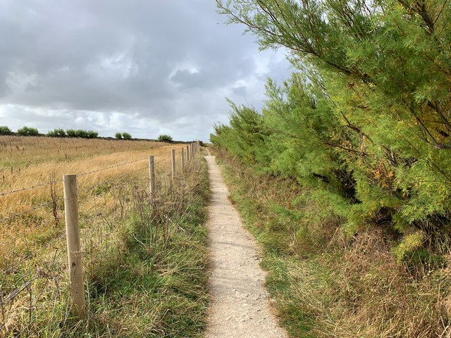
Visitors to Dark Hole can also explore the pebble beaches nestled at the base of the cliffs. These beaches are secluded and offer a peaceful retreat for beachgoers, who can relax and enjoy the sound of the waves and the beauty of the natural surroundings. The beaches are also known for their rock pools, which are teeming with marine life and provide an excellent opportunity for exploration and discovery.

In addition to its natural beauty, Dark Hole is also a popular destination for birdwatching enthusiasts. The headland serves as a vital nesting ground for various seabirds, including gulls, cormorants, and puffins. Birdwatchers can observe these magnificent creatures in their natural habitat, as they soar above the cliffs and dive into the ocean to catch fish.

Overall, Dark Hole in Cornwall offers a captivating blend of stunning cliffs, tranquil beaches, and diverse wildlife. Whether one seeks adventure, relaxation, or the opportunity to marvel at nature's wonders, Dark Hole is a destination that is sure to leave a lasting impression.

If you have any feedback on the listing, please let us know in the comments section below.

Dark Hole Images

Images are sourced within 2km of 50.48461/-5.0339098 or Grid Reference SW8469. Thanks to Geograph Open Source API. All images are credited.

Rickyard of Pentire Farm near Padstow, 1952 This triangular area was used as a rickyard until the National Trust acquired the farm, made this area a car park, made the farmhouse a holiday let, and employed contractors to do the farming. The car in the photo is a 1934 Ford V8.
Rickyard of Pentire Farm near Padstow, 1952
This triangular area was used as a rickyard until the National Trust acquired the farm, made this area a car park, made the farmhouse a holiday let, and employed contractors to do the farming. The car in the photo is a 1934 Ford V8.
Car park and campsite off the B3276 near Efflins
Turning off the B3276 for Old MacDonald's Farm
Road near Treburrick
Coastline, St Eval With Diggory's Island to the right in a view southwards at Pentire Steps.
Coastline, St Eval
With Diggory's Island to the right in a view southwards at Pentire Steps.
Surfers with wooden bellyboards, Pentire Cove 1966 In 2023 wooden surfboards are becoming popular again because they do not pollute the sea with plastic fragments. This photograph harks back to the period from 1940s to the present when we have used wooden bellyboards at this beach and nearby Porthcothan. Park Head is visible on the right.
Surfers with wooden bellyboards, Pentire Cove 1966
In 2023 wooden surfboards are becoming popular again because they do not pollute the sea with plastic fragments. This photograph harks back to the period from 1940s to the present when we have used wooden bellyboards at this beach and nearby Porthcothan. Park Head is visible on the right.
Belly board in surf, Pentire Cove 1966 Surfing on a belly board the body is part on the board, arms to the front holding the end of the board.
Belly board in surf, Pentire Cove 1966
Surfing on a belly board the body is part on the board, arms to the front holding the end of the board.
Road junction on the B3276, looking south-east
On the B3276, heading towards Trevemedar
Pentire Steps with Park Head beyond Pentire Steps were a pathway cut into the cliff to the right of the photo. Parts have crumbled away but it is possible to scramble down onto the rocks. There is another cliff path into Pentire Cove, the sand in the foreground which is covered at high tide. Photo is scan from 35mm Kodachrome slide.
Pentire Steps with Park Head beyond
Pentire Steps were a pathway cut into the cliff to the right of the photo. Parts have crumbled away but it is possible to scramble down onto the rocks. There is another cliff path into Pentire Cove, the sand in the foreground which is covered at high tide. Photo is scan from 35mm Kodachrome slide.
Pentire Cove at half tide At low tide the rock in the centre is surrounded by sand; at high tide all of the sand in the cove is under water. Here the photo is taken from sand at the top of the cove.
Pentire Cove at half tide
At low tide the rock in the centre is surrounded by sand; at high tide all of the sand in the cove is under water. Here the photo is taken from sand at the top of the cove.
Notice, corn bunting and skylark nest sanctuary, Trevemedar Several fields of Trevemedar Farm are maintained with spring crops not harvested. This RSPB notice explains this, reading:
"Sanctuary area
You are entering fields that are a sanctuary for rare ground-nesting corn buntings and skylarks during spring and summer.
To help keep their nests and chicks safe please stay on the main path with your dog on a lead.
Thank you for helping these birds to breed successfully."
Notice, corn bunting and skylark nest sanctuary, Trevemedar
Several fields of Trevemedar Farm are maintained with spring crops not harvested. This RSPB notice explains this, reading: "Sanctuary area You are entering fields that are a sanctuary for rare ground-nesting corn buntings and skylarks during spring and summer. To help keep their nests and chicks safe please stay on the main path with your dog on a lead. Thank you for helping these birds to breed successfully."
Path in ground-nesting bird sanctuary, Trevemedar A number of fields on Trevemedar Farm near Porthcothan are cultivated for the benefit of ground-nesting birds, corn buntings and skylarks. See <a href="https://www.geograph.org.uk/photo/6203106">SW8571 : Notice, corn bunting and skylark nest sanctuary, Trevemedar</a> for notice about this sanctuary.
Path in ground-nesting bird sanctuary, Trevemedar
A number of fields on Trevemedar Farm near Porthcothan are cultivated for the benefit of ground-nesting birds, corn buntings and skylarks. See SW8571 : Notice, corn bunting and skylark nest sanctuary, Trevemedar for notice about this sanctuary.
South West Coast Path diversion The path has been diverted inland near Pentire to avoid collapsing cliff tops.
South West Coast Path diversion
The path has been diverted inland near Pentire to avoid collapsing cliff tops.
Atlantic Coast North of Newquay Taken from a Flybe flight just after take-off from Newquay Airport heading for London Gatwick.
Atlantic Coast North of Newquay
Taken from a Flybe flight just after take-off from Newquay Airport heading for London Gatwick.
Mawgan Porth Beach Taken from a Flybe flight, which has just taken off from Newquay Airport (visible in the background) on the way to London Gatwick.
Mawgan Porth Beach
Taken from a Flybe flight, which has just taken off from Newquay Airport (visible in the background) on the way to London Gatwick.
St Eval airfield radio transmitter station St Eval airfield radio transmitter station.  It is on the site of a former airfield which closed in the 1950s.
St Eval airfield radio transmitter station
St Eval airfield radio transmitter station. It is on the site of a former airfield which closed in the 1950s.
Bedruthan Steps
Bedruthan Steps
Show me another place!

Dark Hole is located at Grid Ref: SW8469 (Lat: 50.48461, Lng: -5.0339098)

Unitary Authority: Cornwall

Police Authority: Devon and Cornwall

What 3 Words

///lobster.diver.spring. Near Newquay, Cornwall

Related Wikis

Carnewas and Bedruthan Steps

Carnewas and Bedruthan Steps (Cornish: Karn Havos, meaning "rock-pile of summer dwelling" and Cornish: Bos Rudhen, meaning "Red-one's dwelling") is a stretch...

Downhill, Cornwall

Downhill is a hamlet in the parish of St Eval, Cornwall, England. == References ==

Trenance

Trenance (Cornish: Trenans) is a hamlet adjoining Mawgan Porth in Cornwall, England, United Kingdom. Trenance Point is a headland nearby.There are also...

Engollan

Engollan is a hamlet 5 miles (8.0 km) south-west of Padstow in Cornwall, England. Engollan is in the civil parish of St Eval. == References == == Views... ==

Nearby Amenities

Located within 500m of 50.48461,-5.0339098
National Trust shop and Cafe
Name En: Carnewas at Bedruthan - National Trust Shop and Café
Phone: +44 1637 860563
Tourism: information
Website: https://www.nationaltrust.org.uk/carnewas-and-bedruthan-steps/
Lat/Long: 50.4815206/-5.0322318
Bedruthan Beach viewpoint
Tourism: viewpoint
Wheelchair: yes
Lat/Long: 50.4846695/-5.0335806
Bedruthan Beach
Addr City: Padstow
Addr Housename: Bedruthan
Addr Postcode: PL27 7UW
Note: Dramatic coastline with views over huge rock stacks This is one of the most popular destinations on the Cornish coast, where spectacular clifftop views stretch across Bedruthan beach (not Trust-owned). The National Trust has rebuilt the cliff staircase
Phone: +44 1637 860563
Website: https://www.nationaltrust.org.uk/carnewas-and-bedruthan-steps/
Wikidata: Q813950
Wikipedia: en:Carnewas and Bedruthan Steps
Lat/Long: 50.4851678/-5.0350075
Bedruthan Steps
Natural: stone
Tourism: attraction
Wikidata: Q813950
Lat/Long: 50.4861929/-5.0341412
Samaritan Island
Place: island
Lat/Long: 50.4879409/-5.0348375
Redcove Island
Place: island
Lat/Long: 50.4861564/-5.0348572
Pendarves Island
Place: island
Lat/Long: 50.484521/-5.035355
Toilets
Lat/Long: 50.4814711/-5.0322317
Cafe
Carnewas Tea Room
Lat/Long: 50.4814217/-5.0322505
Natural: cave_entrance
Wheelchair: yes
Lat/Long: 50.4846846/-5.0341369
Natural: cave_entrance
Lat/Long: 50.4841744/-5.0344775
Bench
Backrest: no
Lat/Long: 50.4840498/-5.0328851
Bench
Backrest: no
Lat/Long: 50.4815195/-5.0341226
Tourism: viewpoint
Lat/Long: 50.4826586/-5.0334058
Bench
Survey Date: 2023-08-19
Lat/Long: 50.4844891/-5.033859
Bench
Survey Date: 2023-08-19
Lat/Long: 50.4829386/-5.0330279
Bench
Backrest: no
Survey Date: 2023-08-19
Lat/Long: 50.4827874/-5.033261
Bench
Backrest: no
Survey Date: 2023-08-19
Lat/Long: 50.482669/-5.0334003
Bench
Backrest: no
Survey Date: 2023-08-19
Lat/Long: 50.4819498/-5.0336634
Bench
Backrest: no
Survey Date: 2023-08-19
Lat/Long: 50.4808194/-5.034521
Cafe
Lat/Long: 50.4851305/-5.0325766
Phone
Emergency: phone
Lat/Long: 50.4843963/-5.0338095
The data included in this document is from www.openstreetmap.org. The data is made available under ODbL.

Have you been to Dark Hole?

Leave your review of Dark Hole below (or comments, questions and feedback).