An Leth-chreag

Coastal Feature, Headland, Point in Ross-shire

Scotland

An Leth-chreag

Rubha Reidh lighthouse This lighthouse is at the end of the (very narrow and twisty in places) road from Gairloch. The light was automated in 1986 and the attached house, once the keeper's house, was sold. It is now a private home and is not open to the public. The lighthouse is a category B listed building.
Rubha Reidh lighthouse Credit: Bill Kasman

An Leth-chreag is a prominent headland located in Ross-shire, Scotland. Situated on the coast, it stands as a striking natural feature that attracts locals and tourists alike. The name "An Leth-chreag" translates to "The Half Rock" in English, derived from the Gaelic language, referring to its unique appearance.

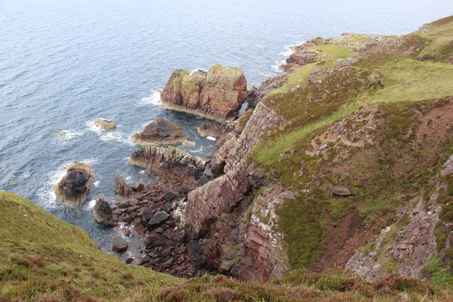
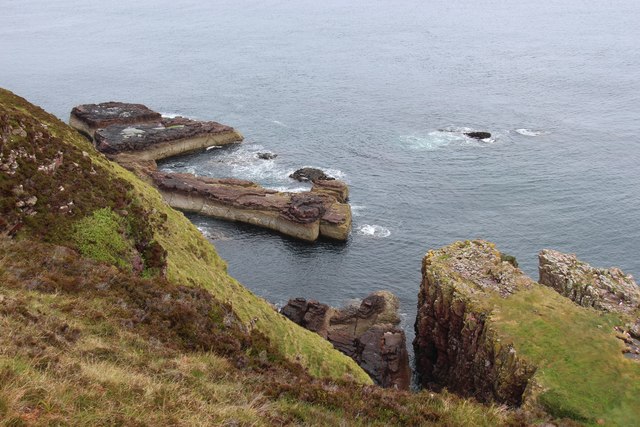
This headland is characterized by its rugged cliffs that jut out into the North Sea, offering breathtaking panoramic views of the surrounding area. The cliffs, composed mainly of sedimentary rock formations, provide a natural habitat for various seabirds such as gannets, kittiwakes, and guillemots. Birdwatchers often flock to this site to observe and study these fascinating creatures.

An Leth-chreag also boasts a diverse range of flora and fauna. The headland is adorned with heather, grasses, and wildflowers, creating a colorful tapestry against the backdrop of the sea. The surrounding waters are home to a variety of marine life, including seals, dolphins, and occasionally even whales.

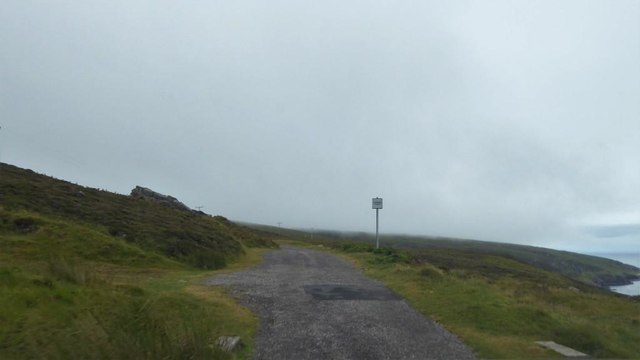
The headland is easily accessible to visitors, with well-maintained footpaths that allow for leisurely walks along its edges. These paths provide an opportunity to explore the headland's geological features up close, including its ancient rock formations and geological fault lines.

An Leth-chreag has historical significance as well, with remnants of Iron Age settlements found in the vicinity. Archaeological excavations have revealed evidence of human occupation, including tools and pottery fragments, offering insights into the lives of past inhabitants.

Overall, An Leth-chreag is a captivating coastal feature that showcases the beauty of Scotland's natural landscape. Its rugged cliffs, diverse wildlife, and historical significance make it a must-visit destination for nature enthusiasts and history buffs alike.

If you have any feedback on the listing, please let us know in the comments section below.

An Leth-chreag Images

Images are sourced within 2km of 57.858216/-5.782192 or Grid Reference NG7591. Thanks to Geograph Open Source API. All images are credited.

Rubha Reidh lighthouse This lighthouse is at the end of the (very narrow and twisty in places) road from Gairloch. The light was automated in 1986 and the attached house, once the keeper's house, was sold. It is now a private home and is not open to the public. The lighthouse is a category B listed building.
Rubha Reidh lighthouse
This lighthouse is at the end of the (very narrow and twisty in places) road from Gairloch. The light was automated in 1986 and the attached house, once the keeper's house, was sold. It is now a private home and is not open to the public. The lighthouse is a category B listed building.
Approaching the lighthouse The road from Melvaig to the Rubha Rèidh lighthouse is maintained by the Northern Lighthouse Board. It is seen here as one nears the lighthouse.
Approaching the lighthouse
The road from Melvaig to the Rubha Rèidh lighthouse is maintained by the Northern Lighthouse Board. It is seen here as one nears the lighthouse.
Old jetty at Port an Amaill
Stacks below Creag Camas an Fhraoich
Looking down to Camas Mòr
Ruins at Camustrolvaig
Old footings in grass below Rubha Rèidh Lighthouse
Passing place on the road to Rubha Rèidh
West facing cliffs at Rubha Reidh
Road to Rubha Reidh Lighthouse
Rubha Reidh Lighthouse
Stac Dubh
Stac Dubh
Sea stack with natural arch
Rock girt bay at Camas Mòr
Camas Mòr
Camas Mòr
Loch nan Eun View towards Greenstone Point.
Loch nan Eun
View towards Greenstone Point.
Moorland above Loch nan Eun Typical of the area, peat hags and scattered rock outcrops bring variety to the moorland scene. The mountains of Letterewe Forest are on the left.
Moorland above Loch nan Eun
Typical of the area, peat hags and scattered rock outcrops bring variety to the moorland scene. The mountains of Letterewe Forest are on the left.
Bogbean emerging from a moorland pool Loch Ewe and the remote Fisherfield Forest mountains on the left.
Bogbean emerging from a moorland pool
Loch Ewe and the remote Fisherfield Forest mountains on the left.
Show me another place!

An Leth-chreag is located at Grid Ref: NG7591 (Lat: 57.858216, Lng: -5.782192)

Unitary Authority: Highland

Police Authority: Highlands and Islands

What 3 Words

///ashes.derailed.implore. Near Gairloch, Highland

Related Wikis

Rua Reidh Lighthouse

Rua Reidh Lighthouse stands close to the entrance to Loch Ewe in Wester Ross, Scotland. == History == The name "Rua Reidh" is a semi-anglicisation of...

Cove, Highland

Cove is a remote hamlet located on the northwestern shore of the sea loch Loch Ewe, and 8 mi (13 km) northwest of Poolewe in Ross-shire, Scottish Highlands...

Melvaig

Melvaig is a remote village on the coast of western Ross-shire, Scottish Highlands and is in the Scottish council area of Highland. It is a cliff top...

Aultgrishan

Aultgrishan (Gaelic: ) is a small crofting community near Gairloch, Ross-shire. It adjoins Melvaig, within Highland region and is in the Scottish council...

Nearby Amenities

Located within 500m of 57.858216,-5.782192
Source: PGS
Lat/Long: 57.861055/-5.7769517
Source: PGS
Lat/Long: 57.8611299/-5.7780831
Source: PGS
Lat/Long: 57.8599708/-5.7779736
Source: PGS
Lat/Long: 57.8597669/-5.7781462
Source: PGS
Lat/Long: 57.8591281/-5.7788344
Source: PGS
Lat/Long: 57.8588497/-5.7797606
Source: PGS
Lat/Long: 57.8587247/-5.7806544
Source: PGS
Lat/Long: 57.8586501/-5.7814728
Source: PGS
Lat/Long: 57.8586334/-5.7825045
Source: PGS
Lat/Long: 57.8589636/-5.7838977
Created By: almien_coastlines
Source: PGS
Lat/Long: 57.859065/-5.784069
Source: PGS
Lat/Long: 57.8592427/-5.7845562
Source: PGS
Lat/Long: 57.8593902/-5.7852046
Created By: almien_coastlines
Source: PGS
Lat/Long: 57.859656/-5.786276
Created By: almien_coastlines
Source: PGS
Lat/Long: 57.859646/-5.786756
Created By: almien_coastlines
Source: PGS
Lat/Long: 57.859635/-5.787236
Created By: almien_coastlines
Source: PGS
Lat/Long: 57.859625/-5.787715
Created By: almien_coastlines
Source: PGS
Lat/Long: 57.859348/-5.788655
Created By: almien_coastlines
Source: PGS
Lat/Long: 57.8592/-5.789605
Created By: almien_coastlines
Source: PGS
Lat/Long: 57.858683/-5.789806
Source: PGS
Lat/Long: 57.8585794/-5.7903186
Camas Mor
Place: locality
Lat/Long: 57.8599585/-5.7821974
The data included in this document is from www.openstreetmap.org. The data is made available under ODbL.

Have you been to An Leth-chreag?

Leave your review of An Leth-chreag below (or comments, questions and feedback).