Roinn an Fhaing Mhòir

Coastal Feature, Headland, Point in Ross-shire

Scotland

Roinn an Fhaing Mhòir

Track to Loch Fada
Track to Loch Fada Credit: Alpin Stewart

Roinn an Fhaing Mhòir, located in Ross-shire, Scotland, is a prominent coastal feature known for its picturesque headland and stunning point. Situated on the northwestern coast of the Highlands, it offers breathtaking views of the surrounding landscape and the vast expanse of the Atlantic Ocean.

The headland at Roinn an Fhaing Mhòir extends out into the sea, forming a distinctive shape that is easily recognizable from a distance. The rugged cliffs that line the headland are composed of ancient rock formations, showcasing the geological history of the area. Visitors to this coastal gem can witness the dramatic waves crashing against the cliffs, creating a mesmerizing spectacle.

The point at Roinn an Fhaing Mhòir provides a vantage point from which to observe the diverse marine life that call this area home. Seals can often be spotted lounging on the rocks, while seabirds soar above, adding to the natural beauty of the location.

The coastal path that meanders along Roinn an Fhaing Mhòir offers an opportunity for visitors to explore the area on foot. Walking along the path, one can appreciate the wildflowers that dot the landscape and breathe in the fresh sea air. The path leads to secluded beaches nestled in small coves, providing a tranquil setting for relaxation and contemplation.

Roinn an Fhaing Mhòir is a haven for nature enthusiasts and photographers alike, offering a unique and captivating coastal experience. Its untouched beauty and captivating vistas make it an ideal destination for those seeking to immerse themselves in the wild and rugged charm of the Scottish Highlands.

If you have any feedback on the listing, please let us know in the comments section below.

Roinn an Fhaing Mhòir Images

Images are sourced within 2km of 57.57847/-5.7990602 or Grid Reference NG7260. Thanks to Geograph Open Source API. All images are credited.
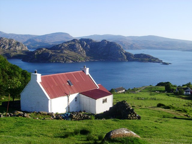
Track to Loch Fada
Track to Loch Fada
A rather uninteresting bend The Applecross to Shieldaig dips briefly into a small valley at this point. The road opened in 1976 to provide the settlements around Applecross with an alternative to the rather challenging Bealach na Ba route over the mountains.  Scattered trees in the background, slightly less than the current OS map would suggest.
A rather uninteresting bend
The Applecross to Shieldaig dips briefly into a small valley at this point. The road opened in 1976 to provide the settlements around Applecross with an alternative to the rather challenging Bealach na Ba route over the mountains. Scattered trees in the background, slightly less than the current OS map would suggest.
Towards the coast at Fearnbeg Moorland leads towards a steep drop down to the entrance to Loch Torridon, on the far side of which, a line of houses can be seen at Lower Diabaig and with the mountains [L-R] of Baosbheinn, An Ruad-mheallan, and the double Munro of Beinn Alligin to the right.
Towards the coast at Fearnbeg
Moorland leads towards a steep drop down to the entrance to Loch Torridon, on the far side of which, a line of houses can be seen at Lower Diabaig and with the mountains [L-R] of Baosbheinn, An Ruad-mheallan, and the double Munro of Beinn Alligin to the right.
Old Milestone south of Fearnbeg, Applecross parish Stone post by the track, in parish of Applecross (District), South of Fearnbeg on indistinct line of track, between road and telegraph poles.

Inscription not recorded.

Surveyed

Milestone Society National ID: HI_APSD14
Old Milestone south of Fearnbeg, Applecross parish
Stone post by the track, in parish of Applecross (District), South of Fearnbeg on indistinct line of track, between road and telegraph poles. Inscription not recorded. Surveyed Milestone Society National ID: HI_APSD14
90m hill
90m hill
Fearnbeg
Fearnbeg
Allt an Fhidhleir
Allt an Fhidhleir
Loch Fada
Loch Fada
Minor road leading to Fearnbeg Looking north-eastward towards Loch Torridon.
Minor road leading to Fearnbeg
Looking north-eastward towards Loch Torridon.
Road (C1091) between Fearnbeg and Fearnmore Looking north-westward. The C1091 coastal road was built in the 1970's and opened in 1975 as an alternative route from Shieldaig to Applecross and avoids the Bealach na Ba road which is often closed in winter.
Road (C1091) between Fearnbeg and Fearnmore
Looking north-westward. The C1091 coastal road was built in the 1970's and opened in 1975 as an alternative route from Shieldaig to Applecross and avoids the Bealach na Ba road which is often closed in winter.
Short track from road (C1091) leading to Loch Fada Looking south-eastward.
Short track from road (C1091) leading to Loch Fada
Looking south-eastward.
Fearnmore Taken from the Applecross road. View over the hamlet Fearnmore and to the junction of Loch Torridon with the Minch. Across the mouth of Loch Torridon lies the Red Point. The skerry seen near Fearnmore is Sgeir a' Ghair.
Fearnmore
Taken from the Applecross road. View over the hamlet Fearnmore and to the junction of Loch Torridon with the Minch. Across the mouth of Loch Torridon lies the Red Point. The skerry seen near Fearnmore is Sgeir a' Ghair.
A dwelling by Roinn an Fhaing Mhòir This cosy retreat nestles on Torridon's shores, a retreat much favoured by the recluse and the midge.
A dwelling by Roinn an Fhaing Mhòir
This cosy retreat nestles on Torridon's shores, a retreat much favoured by the recluse and the midge.
Thrift on the cliffs of Roinn an Fhaing Mhòir Note the angler in the distance in the company of a similarly poised spaniel.
Thrift on the cliffs of Roinn an Fhaing Mhòir
Note the angler in the distance in the company of a similarly poised spaniel.
Pollack fishers on Loch Torridon These anglers are after Pollack, sometimes known as Lithe, on the rocks of Roinn an Fhaing Mhòir.
Pollack fishers on Loch Torridon
These anglers are after Pollack, sometimes known as Lithe, on the rocks of Roinn an Fhaing Mhòir.
Unhooking a Pollack This fish was returned to live another day as were many of his fellows during the day.
Unhooking a Pollack
This fish was returned to live another day as were many of his fellows during the day.
They don't come fresher than this... A Pollack or Lithe from Loch Torridon has fallen victim to a rubber worm from China! This fish is similar to the Coalfish but has a kink in its lateral line unlike the "Coalie" which does not.The Pollack is greatly underrated as a fish for the table and you'll be heartened to learn that the subject specimen, just like so many more of his pals today, was released unscathed to Loch Torridon. Note the £2 piece which will give you an idea of this fish's dimensions.
They don't come fresher than this...
A Pollack or Lithe from Loch Torridon has fallen victim to a rubber worm from China! This fish is similar to the Coalfish but has a kink in its lateral line unlike the "Coalie" which does not.The Pollack is greatly underrated as a fish for the table and you'll be heartened to learn that the subject specimen, just like so many more of his pals today, was released unscathed to Loch Torridon. Note the £2 piece which will give you an idea of this fish's dimensions.
A Cormorant flies low over Loch Torridon The Cormorant is fairly abundant here as is the Shag. The latter, as you can see from the photograph, is slightly smaller than the cormorant and feeds only over salt water whereas the versatile Cormorant can feed anywhere. By the way, those hills in the background are found on the eastern shores of Loch Torridon.
A Cormorant flies low over Loch Torridon
The Cormorant is fairly abundant here as is the Shag. The latter, as you can see from the photograph, is slightly smaller than the cormorant and feeds only over salt water whereas the versatile Cormorant can feed anywhere. By the way, those hills in the background are found on the eastern shores of Loch Torridon.
Show me another place!

Roinn an Fhaing Mhòir is located at Grid Ref: NG7260 (Lat: 57.57847, Lng: -5.7990602)

Unitary Authority: Highland

Police Authority: Highlands and Islands

What 3 Words

///permit.tangling.scarred. Near Gairloch, Highland

Related Wikis

Loch Torridon

Loch Torridon (Scottish Gaelic: Loch Thoirbheartan) is a sea loch on the west coast of Scotland in the Northwest Highlands. The loch was created by glacial...

Ardheslaig

Ardheslaig (Scottish Gaelic: Àird Heisleag) is a crofting settlement at the northern end of the Applecross peninsula in the Scottish Highlands. It is 3...

Diabaig

Diabaig (Scottish Gaelic: Dìobaig) is a remote coastal fishing and crofting township in Wester Ross, in the Northwest Highlands of Scotland. Diabaig lies...

Redpoint

Redpoint (Scottish Gaelic: An Rubha Dearg) is a small settlement in the north west of Highland, Scotland. It takes its name from Red Point, a low promontory...

Nearby Amenities

Located within 500m of 57.57847,-5.7990602
Fainmhor Sea Cave
Name En: Fainmhor Sea Cave
Name Gd: Uamh an Fhaing Mhòr
Natural: cave_entrance
Lat/Long: 57.5758813/-5.800271
Power: pole
Lat/Long: 57.5782657/-5.806951
Power: pole
Lat/Long: 57.5779422/-5.8069007
Power: pole
Lat/Long: 57.5776076/-5.8068342
Power: pole
Lat/Long: 57.5771921/-5.8069998
The data included in this document is from www.openstreetmap.org. The data is made available under ODbL.

Have you been to Roinn an Fhaing Mhòir?

Leave your review of Roinn an Fhaing Mhòir below (or comments, questions and feedback).