Rubha an t-Sasannaich

Coastal Feature, Headland, Point in Argyllshire

Scotland

Rubha an t-Sasannaich

Inninmore Bay Navigation Buoy viewed from the MV Isle of Lewis
Inninmore Bay Navigation Buoy viewed from the MV Isle of Lewis Credit: Peter Moore

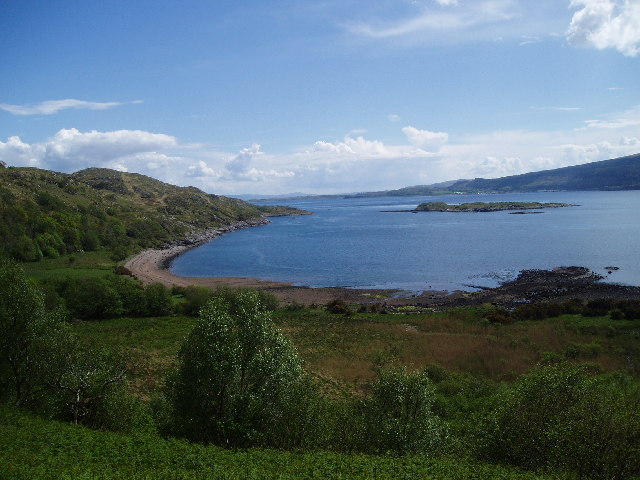
Rubha an t-Sasannaich, also known as the Point of the English, is a prominent headland located in Argyllshire, Scotland. Situated on the west coast of the country, it overlooks the Sound of Jura, offering breathtaking views of the surrounding landscape.

This coastal feature is characterized by its rugged cliffs, which rise dramatically from the sea, creating a striking natural landmark. The headland is predominantly composed of ancient metamorphic rocks, giving it a unique geological profile.

At the tip of Rubha an t-Sasannaich, there is a small lighthouse that has been guiding ships through the treacherous waters of the sound since the 19th century. The lighthouse, with its distinctive white and red stripes, stands tall against the backdrop of the deep blue ocean, adding to the charm and beauty of the point.

The headland is also home to a diverse array of flora and fauna. The coastal heathland and grassy slopes support a range of plant species, including heather, gorse, and wildflowers. It serves as a habitat for various seabirds, such as gannets, puffins, and cormorants, which nest along the cliffs.

Rubha an t-Sasannaich is a popular destination for nature enthusiasts and hikers, who are attracted by its stunning vistas and the opportunity to explore its rugged terrain. The coastal path leading to the headland offers a scenic route for walkers, allowing them to immerse themselves in the natural beauty of the area.

Overall, Rubha an t-Sasannaich is a magnificent coastal feature that combines remarkable geological formations, a historic lighthouse, and abundant wildlife. It is a must-visit location for those seeking an authentic Scottish coastal experience.

If you have any feedback on the listing, please let us know in the comments section below.

Rubha an t-Sasannaich Images

Images are sourced within 2km of 56.517123/-5.7325564 or Grid Reference NM7042. Thanks to Geograph Open Source API. All images are credited.

Inninmore Bay Navigation Buoy viewed from the MV Isle of Lewis
Rough track in the woods at Ardtornish Bay
Shoreline at Ardtornish Bay Water is the Sound of Mull, with Mull on the right
Shoreline at Ardtornish Bay
Water is the Sound of Mull, with Mull on the right
Navigation buoy, Sound of Mull Off Inninmore Bay.
Navigation buoy, Sound of Mull
Off Inninmore Bay.
Aoineadh Mòr A basalt crag on the coast of Morvern. There is a fine oakwood on this shore as well as around the corner on Loch Linnhe.
Aoineadh Mòr
A basalt crag on the coast of Morvern. There is a fine oakwood on this shore as well as around the corner on Loch Linnhe.
Crags above Rubha an t-Sasannaich The Morvern coast on the Sound of Mull.  There are some impressive basalt crags here.
Crags above Rubha an t-Sasannaich
The Morvern coast on the Sound of Mull. There are some impressive basalt crags here.
Isle of Lewis, Inninmore Bay Barra bound ferry in the Sound of Mull.
Isle of Lewis, Inninmore Bay
Barra bound ferry in the Sound of Mull.
Rubha an t-Sasannaich Low promontory backed by grassed scree slopes and cliffs on the Sound of Mull.
Rubha an t-Sasannaich
Low promontory backed by grassed scree slopes and cliffs on the Sound of Mull.
Rubha an t- Sasannaich looking towards Inninmore Bay
The path from Inninmore towards Inninbeg
Waterfall on Allt Leacach It was hard to find any flow of water through some of these small waterfalls. It has been a particularly dry Spring.
Waterfall on Allt Leacach
It was hard to find any flow of water through some of these small waterfalls. It has been a particularly dry Spring.
What remains of two tiny lochans below the summit of Glais Bheinn
The headwaters of Allt Leacach
Rubha an t-Sasannaich From the Inninmore path.
Rubha an t-Sasannaich
From the Inninmore path.
Dyke running up the cliffs of Morvern Looking from the deck of the MV 'Clansman' towards the basalt cliffs of Morvern where a pale line of an igneous dyke can be seen running up the cliff face. The basalt here is around 60 million years old and overlies sedimentary sandstones of the carboniferous period.
Dyke running up the cliffs of Morvern
Looking from the deck of the MV 'Clansman' towards the basalt cliffs of Morvern where a pale line of an igneous dyke can be seen running up the cliff face. The basalt here is around 60 million years old and overlies sedimentary sandstones of the carboniferous period.
Marker beacon for the Yule Rocks The rocks are a permanently submerged hazard in the Sound of Mull.
Marker beacon for the Yule Rocks
The rocks are a permanently submerged hazard in the Sound of Mull.
Inninmore Bay - North cardinal marker buoy, Sound of Mull This buoy in the Sound of Mull between Inninmore Bay on the mainland and Scallastie Bay on Mull is a North Cardinal marker - this is denoted by
a) its colouring - black top, the rest yellow
b) the two cones pointing upwards
Inninmore Bay - North cardinal marker buoy, Sound of Mull
This buoy in the Sound of Mull between Inninmore Bay on the mainland and Scallastie Bay on Mull is a North Cardinal marker - this is denoted by a) its colouring - black top, the rest yellow b) the two cones pointing upwards
Quarry Burn waterfall Several burns tumble down the hillside near the cleared former village of Aoineadh Mòr (Inniemore) - but this is probably the most dramatic as the Quarry Burn cuts through the cliff. Seen from a passing CalMac ferry in the Sound of Mull.
Quarry Burn waterfall
Several burns tumble down the hillside near the cleared former village of Aoineadh Mòr (Inniemore) - but this is probably the most dramatic as the Quarry Burn cuts through the cliff. Seen from a passing CalMac ferry in the Sound of Mull.
Show me another place!

Rubha an t-Sasannaich is located at Grid Ref: NM7042 (Lat: 56.517123, Lng: -5.7325564)

Unitary Authority: Highland

Police Authority: Highlands and Islands

What 3 Words

///timed.schools.flushed. Near Lochaline, Highland

Nearby Locations

Rubha an t-Sasannaich

Related Wikis

Ardtornish Bay

Ardtornish Bay is coastal embayment, on a chord of 0.89 miles, on a 161° orientation, in the Morvern peninsula in Lochaber, in the western coast of Scotland...

Ardtornish Castle

Ardtornish Castle is situated in the grounds of the Ardtornish estate in Morvern, on the west coast of Scotland. It stands at the seaward end of a promontory...

Inninmore Bay

Inninmore Bay is a small shallow coastal embayment, on a chord of 1.74 miles, on a 215° orientation, in the Morvern peninsula in Lochaber, in the western...

HMS Dartmouth (1655)

HMS Dartmouth was a small frigate or fifth-rate ship, one of six ordered by the English Council of State on 28 December 1654, and built in 1655. ��2�...

Nearby Amenities

Located within 500m of 56.517123,-5.7325564
Ford: yes
Lat/Long: 56.5197005/-5.73148
The data included in this document is from www.openstreetmap.org. The data is made available under ODbL.

Have you been to Rubha an t-Sasannaich?

Leave your review of Rubha an t-Sasannaich below (or comments, questions and feedback).