An Gobhlach

Coastal Feature, Headland, Point in Inverness-shire

Scotland

An Gobhlach

Pabay Viewed from the approach to the Skye Bridge at Plock of Kyle.
Pabay Credit: John Lucas

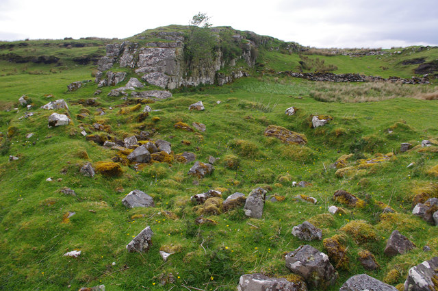
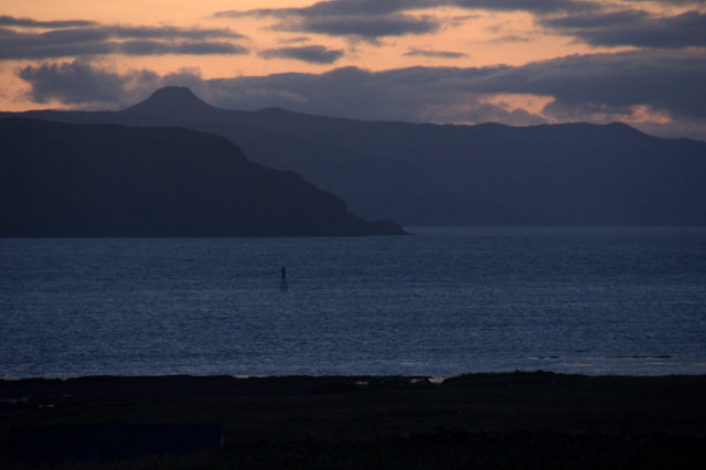
An Gobhlach is a prominent headland located in Inverness-shire, Scotland. It is situated on the coast, overlooking the Moray Firth, and is known for its rugged cliffs and stunning views of the surrounding coastline.

The headland is a popular destination for hikers and outdoor enthusiasts, offering a variety of walking trails and opportunities to observe local wildlife such as seabirds and seals. The area is also rich in history, with ancient ruins and archaeological sites scattered throughout the landscape.

An Gobhlach is known for its dramatic natural beauty, with steep cliffs that plunge into the sea below. The headland is surrounded by pristine beaches and crystal-clear waters, making it a picturesque spot for photography and relaxation.

Visitors to An Gobhlach can enjoy panoramic views of the ocean and nearby islands, as well as the chance to explore the rugged terrain and discover hidden coves and caves along the coastline. Whether you're looking for a peaceful retreat or an adventurous outing, An Gobhlach offers something for everyone to enjoy.

If you have any feedback on the listing, please let us know in the comments section below.

An Gobhlach Images

Images are sourced within 2km of 57.266156/-5.8692927 or Grid Reference NG6626. Thanks to Geograph Open Source API. All images are credited.

Pabay Viewed from the approach to the Skye Bridge at Plock of Kyle.
Pabay
Viewed from the approach to the Skye Bridge at Plock of Kyle.
Ardnish An isolated tree on rough grassland. The small outcrops face south or SE.
Ardnish
An isolated tree on rough grassland. The small outcrops face south or SE.
Outcrop, Ardnish This appears to me to be a limestone dyke.
Outcrop, Ardnish
This appears to me to be a limestone dyke.
Rubha Ardnish Eilean na Ruadhaich (mid distance, left of centre) is accessible at low water.
Rubha Ardnish
Eilean na Ruadhaich (mid distance, left of centre) is accessible at low water.
Eilean na Ruadhaich Looking east from the island, which is accessible at low water.
Eilean na Ruadhaich
Looking east from the island, which is accessible at low water.
Eilean na Ruadhaich Looking north from the island, which is accessible at low water.
The islands in the distance are Pabay (left) and the Crowlin Islands (centre).
Eilean na Ruadhaich
Looking north from the island, which is accessible at low water. The islands in the distance are Pabay (left) and the Crowlin Islands (centre).
Eilean na Ruadhaich Looking NE from the island, which is accessible at low water.
The islands in the distance are the Crowlin Islands (extreme left) and Sgeir Dubh (extreme right).
Eilean na Ruadhaich
Looking NE from the island, which is accessible at low water. The islands in the distance are the Crowlin Islands (extreme left) and Sgeir Dubh (extreme right).
Rubha Ardnish This appears to me to be a limestone dyke.
In the background, are the red hills across Broadford Bay.
Rubha Ardnish
This appears to me to be a limestone dyke. In the background, are the red hills across Broadford Bay.
Beacon on Sgeir Gobhlach from Lower Breakish (Breacais Iosal) In the background is the east side of Scalpay and the distinctive profile of Dun Caan on Raasay.
Beacon on Sgeir Gobhlach from Lower Breakish (Breacais Iosal)
In the background is the east side of Scalpay and the distinctive profile of Dun Caan on Raasay.
Pabay east coast A rocky shoreline, seen on a glorious spring day.
Pabay east coast
A rocky shoreline, seen on a glorious spring day.
View across Broadford Bay View towards the north of Skye and the Cuillins from the beach below the Broadford airstrip
View across Broadford Bay
View towards the north of Skye and the Cuillins from the beach below the Broadford airstrip
View across Broadford Bay from Lower Breakish Looking west across Broadford Bay on a calm morning.
View across Broadford Bay from Lower Breakish
Looking west across Broadford Bay on a calm morning.
Jetty At Pabay We powered under the Skye Bridge to be dropped off near the shell beach on Pabay to walk to the island highpoint and trig. Then down for collection at Pabay Jetty on a dull wet afternoon.
Jetty At Pabay
We powered under the Skye Bridge to be dropped off near the shell beach on Pabay to walk to the island highpoint and trig. Then down for collection at Pabay Jetty on a dull wet afternoon.
Pabay Vanessa Trig We landed near the shell beach then bagged likely island highpoint before bagging the Vanessa trig. Eventually walked back to use the jetty for our departure.
Pabay Vanessa Trig
We landed near the shell beach then bagged likely island highpoint before bagging the Vanessa trig. Eventually walked back to use the jetty for our departure.
Drainage Ditch On Pabay
Broadford bay and the Skye bridge in the distance
Standing within square NG6726 looking westward past the Pabay Post Box On a bright April day I had the pleasure to visit Pabay. In this image one looks past the one and only Post Box on the Island westward towards the Isles of Skye and Scalpay. The large hill to the left of the Post Box is Beinn na Caillich the summit of which is recorded as 732m. Scalpay is on the righthand side of the image with the Caolas Scalpay between it and Skye.
Standing within square NG6726 looking westward past the Pabay Post Box
On a bright April day I had the pleasure to visit Pabay. In this image one looks past the one and only Post Box on the Island westward towards the Isles of Skye and Scalpay. The large hill to the left of the Post Box is Beinn na Caillich the summit of which is recorded as 732m. Scalpay is on the righthand side of the image with the Caolas Scalpay between it and Skye.
Wind Generator remains on Pabay's west coast. Beyond the hurricane destroyed windmill on Pabay's west coast can be seen the flat topped hill of Dun Caan on the Isle of Raasay.
Wind Generator remains on Pabay's west coast.
Beyond the hurricane destroyed windmill on Pabay's west coast can be seen the flat topped hill of Dun Caan on the Isle of Raasay.
Show me another place!

An Gobhlach is located at Grid Ref: NG6626 (Lat: 57.266156, Lng: -5.8692927)

Unitary Authority: Highland

Police Authority: Highlands and Islands

What 3 Words

///salt.thinks.badminton. Near Broadford, Highland

Nearby Locations

An Gobhlach

Related Wikis

Pabay

Pabay is a Scottish island just off the coast of Skye. The name Pabay is derived from an old Norse word meaning "priest's isle" and there are the remains...

Ross, Skye and Lochaber (UK Parliament constituency)

Ross, Skye and Lochaber is a constituency of the House of Commons of the Parliament of the United Kingdom (Westminster). It elects one Member of Parliament...

Harrapool

Harrapool (Scottish Gaelic: Harrapul) is a village, that lies on the right hand side of Broadford Bay, in Isle of Skye, Scottish Highlands and is in the...

Broadford Airfield

Isle of Skye (Broadford) Airfield (also known as Ashaig Airstrip or Broadford Aerodrome) is a small airfield on the Isle of Skye, Scotland, with a single...

Nearby Amenities

Located within 500m of 57.266156,-5.8692927
An Gobhlach
Place: locality
Lat/Long: 57.2671928/-5.8684474
The data included in this document is from www.openstreetmap.org. The data is made available under ODbL.

Have you been to An Gobhlach?

Leave your review of An Gobhlach below (or comments, questions and feedback).