An Feadan

Coastal Feature, Headland, Point in Inverness-shire

Scotland

An Feadan

Loch Beag, Raasay A small loch towards the northern end of the island.
Loch Beag, Raasay Credit: Des Blenkinsopp

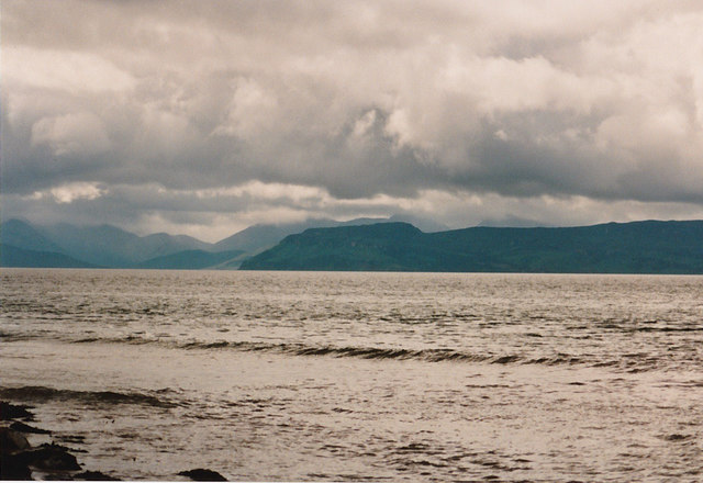
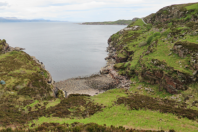
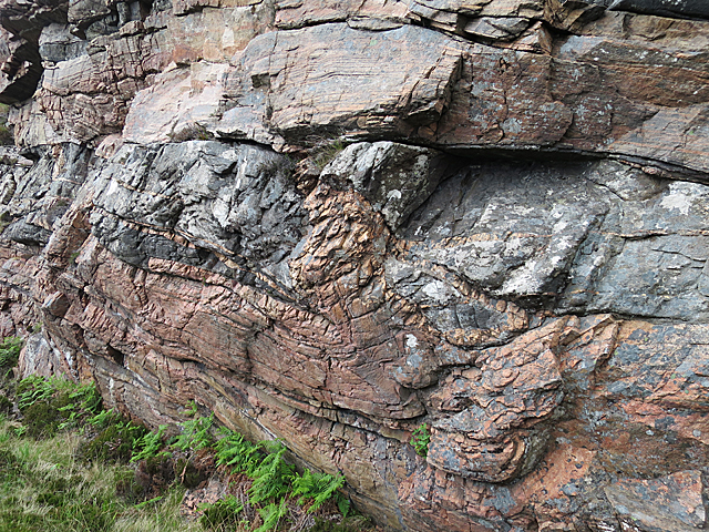
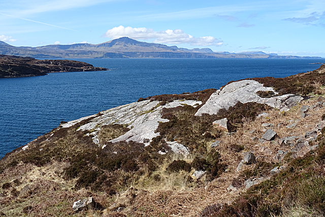
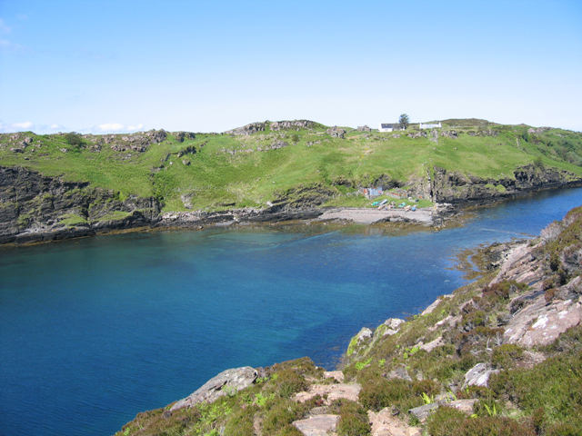
An Feadan is a rugged and picturesque headland located in Inverness-shire, Scotland. This coastal feature juts out into the North Sea, offering stunning views of the surrounding landscape. The headland is characterized by its rocky cliffs, which provide a habitat for a variety of seabirds such as gulls, puffins, and razorbills.

An Feadan is a popular destination for hikers and nature enthusiasts, who come to explore the rugged coastline and observe the diverse marine life in the area. The headland is also home to a variety of plant species, including sea thrift and sea campion, which add to its natural beauty.

Visitors to An Feadan can enjoy walking along the cliff-top paths, taking in the panoramic views of the sea and surrounding countryside. The headland is also a great spot for birdwatching, with opportunities to spot a wide range of seabirds nesting on the cliffs.

Overall, An Feadan is a stunning coastal feature that offers visitors a chance to experience the natural beauty of the Scottish coastline in all its glory.

If you have any feedback on the listing, please let us know in the comments section below.

An Feadan Images

Images are sourced within 2km of 57.458102/-6.0016042 or Grid Reference NG6047. Thanks to Geograph Open Source API. All images are credited.

Loch Beag, Raasay A small loch towards the northern end of the island.
Loch Beag, Raasay
A small loch towards the northern end of the island.
View to Raasay From the edge of the sandy beach at Sand looking across the water towards Raasay and beyond to Skye.
View to Raasay
From the edge of the sandy beach at Sand looking across the water towards Raasay and beyond to Skye.
Kyle of Rona Footpath on the Isle of Raasay View along the footpath from Arnish to the Kyle of Rona at the northern end of the Isle of Raasay.  The view here is facing east along the path from the saddle point just the south of Beinn na h-Iolaire, the hill of the eagle.  The land across the water is mainland Britain.
Kyle of Rona Footpath on the Isle of Raasay
View along the footpath from Arnish to the Kyle of Rona at the northern end of the Isle of Raasay. The view here is facing east along the path from the saddle point just the south of Beinn na h-Iolaire, the hill of the eagle. The land across the water is mainland Britain.
The eastern coast A rocky outcrop at the coast.  The Applecross peninsula on the mainland in the background.
The eastern coast
A rocky outcrop at the coast. The Applecross peninsula on the mainland in the background.
The coast east of Arnish with the mainland in the background
The coast  north east of Arnish
The coast north east of Arnish
Raasay in the Mists Taken from the Leac Tressirnish viewpoint at the East coast of Trotternish peninsula (A855) on an overcast morning. View over the Sound of Raasay to the namesake island. The view is centred at Loch Arnish (<a href="https://www.geograph.org.uk/gridref/NG5848">NG5848</a>), which is surrounded by those portions of Raasay which come out clearest from the surrounding mist.
Raasay in the Mists
Taken from the Leac Tressirnish viewpoint at the East coast of Trotternish peninsula (A855) on an overcast morning. View over the Sound of Raasay to the namesake island. The view is centred at Loch Arnish (NG5848), which is surrounded by those portions of Raasay which come out clearest from the surrounding mist.
Footpath from Arnish to the north of Raasay This footpath starts from the end of the surfaced road to Arnish, and goes to the north of Raasay.

<a href="https://www.geograph.org.uk/photo/2836137">NG5948 : End of the public road at Arnish, Raasay</a>.
Footpath from Arnish to the north of Raasay
This footpath starts from the end of the surfaced road to Arnish, and goes to the north of Raasay. NG5948 : End of the public road at Arnish, Raasay.
End of the public road at Arnish, Raasay The public road goes no further than this point. The last section to here was dug out by one man, before the Council surfaced it, and it is commonly known as Calum's Road, in tribute to him. The great irony is that, by the time that was done, Calum and his wife were the only people still living here. There are a very few cottages nearby, which may now be lived in permanently, but more likely are holiday cottages. On the left is the start of the footpath to the north of the island.

<a href="https://www.geograph.org.uk/photo/2836062">NG5948 : Footpath from Arnish to the north of Raasay</a>.
End of the public road at Arnish, Raasay
The public road goes no further than this point. The last section to here was dug out by one man, before the Council surfaced it, and it is commonly known as Calum's Road, in tribute to him. The great irony is that, by the time that was done, Calum and his wife were the only people still living here. There are a very few cottages nearby, which may now be lived in permanently, but more likely are holiday cottages. On the left is the start of the footpath to the north of the island. NG5948 : Footpath from Arnish to the north of Raasay.
Signpost at Arnish, Raasay Located at the beginning of the footpath to the north of the island, and giving distances to various places.

<a href="https://www.geograph.org.uk/photo/2836137">NG5948 : End of the public road at Arnish, Raasay</a>.
Signpost at Arnish, Raasay
Located at the beginning of the footpath to the north of the island, and giving distances to various places. NG5948 : End of the public road at Arnish, Raasay.
The road south from Arnish, Raasay This is the only road in this part of the island. It goes a few kilometres south from Arnish, through rugged terrain, providing a link to both the ferry at Clachan and the main centre of population at Inverarish, passing through Brochel on its way. On the right is part of the small parking area at Arnish. Cars can go no further north, but it is a useful place to leave your vehicle and explore the north of the island by foot.
The road south from Arnish, Raasay
This is the only road in this part of the island. It goes a few kilometres south from Arnish, through rugged terrain, providing a link to both the ferry at Clachan and the main centre of population at Inverarish, passing through Brochel on its way. On the right is part of the small parking area at Arnish. Cars can go no further north, but it is a useful place to leave your vehicle and explore the north of the island by foot.
Junction of Paths This is where the path to Fladda splits off to the left from the main path between Torran and Caol Rona
Junction of Paths
This is where the path to Fladda splits off to the left from the main path between Torran and Caol Rona
Tairbeart The name occurs, with spelling variations, all over Scotland. It means a narrow isthmus. The rocks here are Lewisian Gneiss, the oldest rocks in Scotland and some of the oldest anywhere on Earth, with ages going up to three and a half thousand million years.
Tairbeart
The name occurs, with spelling variations, all over Scotland. It means a narrow isthmus. The rocks here are Lewisian Gneiss, the oldest rocks in Scotland and some of the oldest anywhere on Earth, with ages going up to three and a half thousand million years.
Lewisian Gneiss These rocks are typical of the Lewisian Gneiss that underlies most of Scotland. The pink rocks have been extensively metamorphosed, deformed, partly melted and recrystallised since their formation over 3,500 million years ago, and they have been intruded by black igneous rocks at various times since then, resulting in a very complicated rock.
Lewisian Gneiss
These rocks are typical of the Lewisian Gneiss that underlies most of Scotland. The pink rocks have been extensively metamorphosed, deformed, partly melted and recrystallised since their formation over 3,500 million years ago, and they have been intruded by black igneous rocks at various times since then, resulting in a very complicated rock.
The Landlord's Dyke During the Highland Clearances, the landlord forced all the islanders to remove to the northern end of the island, and had a dyke built across the isthmus to keep them out of the better land further south.
The Landlord's Dyke
During the Highland Clearances, the landlord forced all the islanders to remove to the northern end of the island, and had a dyke built across the isthmus to keep them out of the better land further south.
Tairbeart An inlet of Loch Arnish, at the narrowest point of the island. Calum's Road runs along the far side of the inlet.
Tairbeart
An inlet of Loch Arnish, at the narrowest point of the island. Calum's Road runs along the far side of the inlet.
Near Rubha Crion Bare rocks are exposed beside Calum's Road. The Storr in the background.
Near Rubha Crion
Bare rocks are exposed beside Calum's Road. The Storr in the background.
Flying Pig Sign This sign warning of humps in the road has famously been tampered with by the addition of a flying pig. I has been there since at least 2008 - see <a href="https://www.geograph.org.uk/photo/922981">NG5846 : Unusual sign on Calum's Road</a>.
Flying Pig Sign
This sign warning of humps in the road has famously been tampered with by the addition of a flying pig. I has been there since at least 2008 - see NG5846 : Unusual sign on Calum's Road.
Show me another place!

An Feadan is located at Grid Ref: NG6047 (Lat: 57.458102, Lng: -6.0016042)

Unitary Authority: Highland

Police Authority: Highlands and Islands

What 3 Words

///vanilla.horns.hazelnuts. Near Portree, Highland

Nearby Locations

Creag na Gaoithe An Feadan

Related Wikis

Eilean Fladday

Eilean Fladday (also Fladda; Scottish Gaelic: Eilean Fladaigh) is a previously populated tidal island off Raasay, near the Isle of Skye, Scotland. ��2...

Eilean Tigh

Eilean Tigh (Scottish Gaelic: Eilean Taighe) is a tidal island in the Sound of Raasay of Scotland, that lies between Rona and Raasay. Approximately 54...

Inner Sound, Scotland

The Inner Sound (Scottish Gaelic: An Lighe Rathairseach) is a strait separating the Inner Hebridean islands of Skye, Raasay and South Rona from the Applecross...

Raasay

Raasay (; Scottish Gaelic: Ratharsair) or the Isle of Raasay is an island between the Isle of Skye and the mainland of Scotland. It is separated from Skye...

Nearby Amenities

Located within 500m of 57.458102,-6.0016042
Source: PGS
Lat/Long: 57.4608198/-5.9952048
Source: PGS
Lat/Long: 57.4606832/-5.9953281
Source: PGS
Lat/Long: 57.4603225/-5.9954365
Source: PGS
Lat/Long: 57.4595281/-5.9958762
Source: PGS
Lat/Long: 57.4593797/-5.9958944
Source: PGS
Lat/Long: 57.4591426/-5.9961296
Source: PGS
Lat/Long: 57.4588222/-5.9965314
Source: PGS
Lat/Long: 57.4585093/-5.9967887
Source: PGS
Lat/Long: 57.4578815/-5.9995785
Source: PGS
Lat/Long: 57.457398/-5.9990645
Source: PGS
Lat/Long: 57.4567813/-5.9987364
Source: PGS
Lat/Long: 57.4559874/-5.998875
Created By: almien_coastlines
Source: PGS
Lat/Long: 57.455597/-5.998767
Source: PGS
Lat/Long: 57.455263/-5.9999414
Source: PGS
Lat/Long: 57.4551722/-6.0000163
Source: PGS
Lat/Long: 57.4550959/-6.0016078
Source: PGS
Lat/Long: 57.4551195/-6.0019826
Source: PGS
Lat/Long: 57.4548283/-6.0021228
Source: PGS
Lat/Long: 57.4546549/-6.0019725
Source: PGS
Lat/Long: 57.4544364/-6.0020437
Source: PGS
Lat/Long: 57.4536727/-6.0023841
The data included in this document is from www.openstreetmap.org. The data is made available under ODbL.

Have you been to An Feadan?

Leave your review of An Feadan below (or comments, questions and feedback).