Carn Gloose

Coastal Feature, Headland, Point in Cornwall

England

Carn Gloose

'Wild' ponies at Bosigran The tenant at Bosigran farm has left and taken his Belted Galloway cattle with him. The National Trust have replaced them with ponies from a pony sanctuary. They roam freely, but they don't graze as efficiently as the cattle.  The fields are reverting to long grass and bracken.
'Wild' ponies at Bosigran Credit: David Medcalf

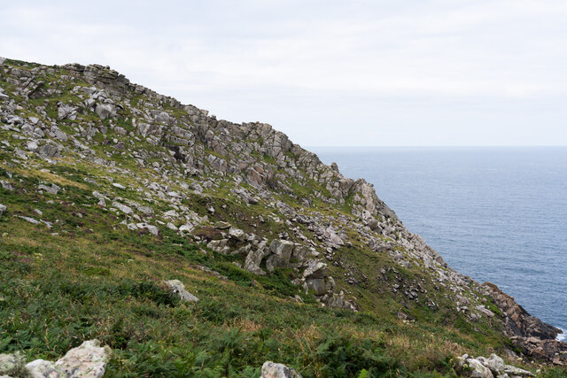
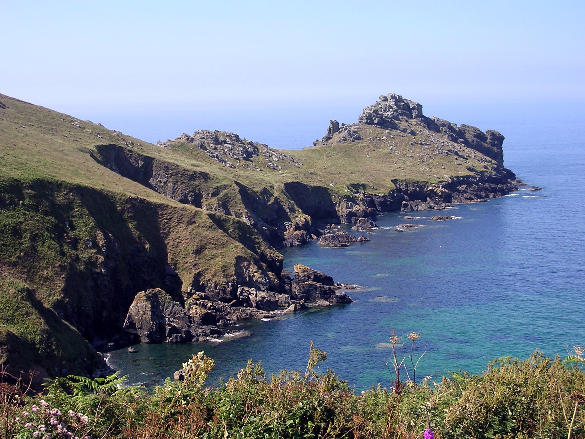
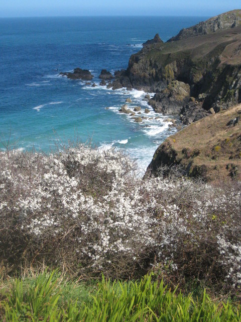
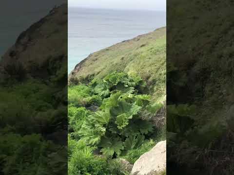
Carn Gloose is a prominent coastal feature located in Cornwall, England. It is a headland that juts out into the Atlantic Ocean, forming a distinct point along the rugged coastline. With its dramatic cliffs and stunning views, Carn Gloose is a popular destination for visitors and locals alike.

Situated near the village of St. Just, Carn Gloose offers breathtaking panoramic vistas of the surrounding seascape. From its vantage point, visitors can witness the powerful waves crashing against the towering cliffs, creating a mesmerizing spectacle. The headland is also known for its rich biodiversity, with various species of seabirds nesting in the cliffs and marine life thriving in the surrounding waters.

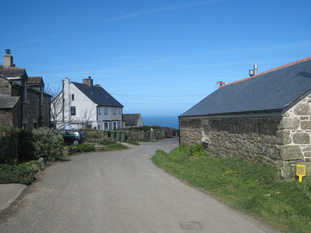
Carn Gloose is accessible via a coastal path that winds its way along the edge of the cliffs, providing hikers and nature enthusiasts with an exhilarating experience. The path offers stunning views of the rugged coastline, with its rocky coves, secluded beaches, and hidden caves. It is also a popular spot for birdwatching, as the headland attracts a diverse range of species, including puffins, gannets, and razorbills.

Aside from its natural beauty, Carn Gloose is steeped in history and folklore. The headland is dotted with ancient burial mounds and stone circles, hinting at its significance in prehistoric times. Legend has it that Carn Gloose was once home to giants, who would hurl huge rocks into the sea to create the nearby rocky outcrops.

In conclusion, Carn Gloose is a captivating coastal feature in Cornwall, offering stunning views, diverse wildlife, and a rich historical background. It is a must-visit destination for anyone seeking to experience the beauty and grandeur of the Cornish coastline.

If you have any feedback on the listing, please let us know in the comments section below.

Carn Gloose Images

Images are sourced within 2km of 50.188/-5.6023263 or Grid Reference SW4238. Thanks to Geograph Open Source API. All images are credited.

'Wild' ponies at Bosigran The tenant at Bosigran farm has left and taken his Belted Galloway cattle with him. The National Trust have replaced them with ponies from a pony sanctuary. They roam freely, but they don't graze as efficiently as the cattle.  The fields are reverting to long grass and bracken.
'Wild' ponies at Bosigran
The tenant at Bosigran farm has left and taken his Belted Galloway cattle with him. The National Trust have replaced them with ponies from a pony sanctuary. They roam freely, but they don't graze as efficiently as the cattle. The fields are reverting to long grass and bracken.
Path near Bosigran, with Can Galver Engine House in the distance
Porthmeor Cove from the South West Coast Path
Stone Stile SW4236a Cattle stile with granite block balanced on two blocks and one granite step each side; next to gate, probably originally a field stile. Footpath on National Trust land from B3306 to Bosigran cliff castle and SW coast path. On open land. First stile on this footpath north of the B3306 and Carn Galver 
Within farmland from the Porthmeor Stream to Porthmoina Stream.
Photo by Dr Charlotte MacKenzie
Stone Stile SW4236a
Cattle stile with granite block balanced on two blocks and one granite step each side; next to gate, probably originally a field stile. Footpath on National Trust land from B3306 to Bosigran cliff castle and SW coast path. On open land. First stile on this footpath north of the B3306 and Carn Galver Within farmland from the Porthmeor Stream to Porthmoina Stream. Photo by Dr Charlotte MacKenzie
Stone Stile SW4236a Cattle stile with granite block balanced on two blocks and one granite step each side; next to gate, probably originally a field stile. Footpath on National Trust land from B3306 to Bosigran cliff castle and SW coast path.  On open land. First stile on this footpath north of the B3306 and Carn Galver. Within farmland from the Porthmeor Stream to Porthmoina Stream.
Stone Stile SW4236a
Cattle stile with granite block balanced on two blocks and one granite step each side; next to gate, probably originally a field stile. Footpath on National Trust land from B3306 to Bosigran cliff castle and SW coast path. On open land. First stile on this footpath north of the B3306 and Carn Galver. Within farmland from the Porthmeor Stream to Porthmoina Stream.
Stone Stile SW4236b On farm land north of B3306 and west of Bosigran farm buildings, next to farm gate on track between late prehistoric and medieval field boundaries at Bosigran. On public footpath 120/15/2 Gold. Cattle stile with granite block balanced on two blocks and one granite step each side; next to gate. Looking west.
Stone Stile SW4236b
On farm land north of B3306 and west of Bosigran farm buildings, next to farm gate on track between late prehistoric and medieval field boundaries at Bosigran. On public footpath 120/15/2 Gold. Cattle stile with granite block balanced on two blocks and one granite step each side; next to gate. Looking west.
Stone Stile SW4236b On farm land north of B3306 and west of Bosigran farm buildings, next to farm gate on track between late prehistoric and medieval field boundaries at Bosigran. On public footpath 120/15/2 Gold. Cattle stile with granite block balanced on two blocks and one granite step each side; next to gate. Looking east to Bosigran farmstead
Stone Stile SW4236b
On farm land north of B3306 and west of Bosigran farm buildings, next to farm gate on track between late prehistoric and medieval field boundaries at Bosigran. On public footpath 120/15/2 Gold. Cattle stile with granite block balanced on two blocks and one granite step each side; next to gate. Looking east to Bosigran farmstead
Stone Stile SW4237a Boundary from field into Bosigran farm buildings, on Bosigran farm land north of B3306, west of Porthmeor stream. Public footpath 120/15/1 and 120/14/3 Gold. Circa early C19. Dressed granite moorstone and granite rubble. Stepped cattle stile adjoining rubble-faced hedge. Parish: Zennor
HER Number: DCO11754  Grade II listed No. 1144347
Stone Stile SW4237a
Boundary from field into Bosigran farm buildings, on Bosigran farm land north of B3306, west of Porthmeor stream. Public footpath 120/15/1 and 120/14/3 Gold. Circa early C19. Dressed granite moorstone and granite rubble. Stepped cattle stile adjoining rubble-faced hedge. Parish: Zennor HER Number: DCO11754 Grade II listed No. 1144347
Stone Stile SW4237a Boundary from field into Bosigran farm buildings, on Bosigran farm land north of B3306, west of Porthmeor stream. Public footpath 120/15/1 and 120/14/3 Gold. Dressed granite moorstone and granite rubble. Stepped cattle stile adjoining rubble-faced hedge.
Parish: Zennor
HER Number: DCO11754  Grade II listed No. 1144347
Stone Stile SW4237a
Boundary from field into Bosigran farm buildings, on Bosigran farm land north of B3306, west of Porthmeor stream. Public footpath 120/15/1 and 120/14/3 Gold. Dressed granite moorstone and granite rubble. Stepped cattle stile adjoining rubble-faced hedge. Parish: Zennor HER Number: DCO11754 Grade II listed No. 1144347
Stone Stile SW4237b Three stone steps. At eastern end of enclosed track at Bosigran/Lower Porthmeor tin working site. The stile leads south from the enclosed lane, at right angles to a second stile which is on the main path running east. Path number 120/14 gold.
Parish: Zennor
HER Number: DCO11914  Grade II listed 1137458 ‘Aqueduct and Stiles’
Stone Stile SW4237b
Three stone steps. At eastern end of enclosed track at Bosigran/Lower Porthmeor tin working site. The stile leads south from the enclosed lane, at right angles to a second stile which is on the main path running east. Path number 120/14 gold. Parish: Zennor HER Number: DCO11914 Grade II listed 1137458 ‘Aqueduct and Stiles’
Stone Stile SW4237c Cattle stile with three large steps. Public footpath 120/14/3 gold & 120/14/2 silver from: Bosigran to: Lower Porthmeor. 
Parish: Zennor
HER Number: DCO11914  Grade II listed 1137458 ‘Aqueduct and Stiles’
Stone Stile SW4237c
Cattle stile with three large steps. Public footpath 120/14/3 gold & 120/14/2 silver from: Bosigran to: Lower Porthmeor. Parish: Zennor HER Number: DCO11914 Grade II listed 1137458 ‘Aqueduct and Stiles’
Stone Stile SW4237c Cattle stile with three large steps. Public footpath 120/14/3 gold & 120/14/2 silver from Bosigran to Lower Porthmeor. 
Parish: Zennor
HER Number: DCO11914  Grade II listed 1137458 ‘Aqueduct and Stiles’
Stone Stile SW4237c
Cattle stile with three large steps. Public footpath 120/14/3 gold & 120/14/2 silver from Bosigran to Lower Porthmeor. Parish: Zennor HER Number: DCO11914 Grade II listed 1137458 ‘Aqueduct and Stiles’
Stone Stile SW4237d Cattle stile with three large steps each side. At western end of enclosed track at Bosigran/Lower Porthmeor tin working site. Public footpath 120/14/3 gold 
Parish: Zennor
HER Number: DCO11914  Grade II listed 1137458 ‘Aqueduct and Stiles’
Stone Stile SW4237d
Cattle stile with three large steps each side. At western end of enclosed track at Bosigran/Lower Porthmeor tin working site. Public footpath 120/14/3 gold Parish: Zennor HER Number: DCO11914 Grade II listed 1137458 ‘Aqueduct and Stiles’
Cliffs down to Halldrine Cove from South West Coastal Path
Footpath looking west near Captain's House in Portmeor
Stone Stile Sw4337a Zennor A cattle stile with two steps each side situated at the commencement of a footpath heading off the B3306. There is a small stream here. Public footpath 120/9/1 B3306 to Treen.
Stone Stile Sw4337a Zennor
A cattle stile with two steps each side situated at the commencement of a footpath heading off the B3306. There is a small stream here. Public footpath 120/9/1 B3306 to Treen.
Stone Stile SW4337a Zennor Cattle stile with two steps each side, situated at the commencement of a footpath heading off the B3306. There is a small stream here. Looking west, the yellow-painted Gurnard's Head inn can be seen, approximately a quarter of a mile away at Treen. Public footpath 120/9/1 B3306 to Treen
Stone Stile SW4337a Zennor
Cattle stile with two steps each side, situated at the commencement of a footpath heading off the B3306. There is a small stream here. Looking west, the yellow-painted Gurnard's Head inn can be seen, approximately a quarter of a mile away at Treen. Public footpath 120/9/1 B3306 to Treen
Show me another place!

Carn Gloose is located at Grid Ref: SW4238 (Lat: 50.188, Lng: -5.6023263)

Unitary Authority: Cornwall

Police Authority: Devon and Cornwall

What 3 Words

///speaking.gashes.optimists. Near St Ives, Cornwall

Related Wikis

Gurnard's Head

Gurnard's Head (Cornish: Ynyal, meaning desolate one; grid reference SW432386) is a prominent headland on the north coast of the Penwith peninsula in Cornwall...

Treen Cove

Treen Cove (grid reference SW435383) is a tidal beach on the north coast of the Penwith peninsula, Cornwall, England, UK. It is about half a mile northwest...

Treen, Zennor

Treen (Cornish: Tredhin) is a hamlet in the parish of Zennor, on the north coast of the Penwith peninsula in Cornwall, England, United Kingdom. It lies...

Boswednack

Boswednack is a hamlet in the parish of Zennor near the north coast of the Penwith peninsula in Cornwall, England, United Kingdom. It is located along...

Related Videos

Travel & Walking Cornwall Part 10 Porthmeor Cove

Stunning cliff top walk to find Porthmeor Cove in Cornwall on a beautiful crisp and sunny September morning.

Travel & Walking Car Camping Cornwall Part 11 Veor Cove

Final part of my first car camping beach finding trip to Cornwall. This was probably the most difficult of my walks but I managed to ...

Zennor In The Autumn, Cornwall, UK #zennor #cornwall

A short video of a walk around the small village of Zennor on a lovely but blustery Autumn afternoon. I hope you enjoy my video.

Nearby Amenities

Located within 500m of 50.188,-5.6023263
Source: Bing
Lat/Long: 50.189519/-5.596386
Source: Bing
Lat/Long: 50.1910528/-5.5990671
Source: Bing
Lat/Long: 50.1910416/-5.5990268
Source: Bing
Lat/Long: 50.191009/-5.599063
Source: Bing
Lat/Long: 50.1890994/-5.6015521
Source: Bing
Lat/Long: 50.1907937/-5.5990302
Source: Bing
Lat/Long: 50.1887164/-5.5953991
Source: Bing
Lat/Long: 50.188725/-5.5954903
Source: Bing
Lat/Long: 50.1887353/-5.5955252
Source: Bing
Lat/Long: 50.1887559/-5.5955493
Source: Bing
Lat/Long: 50.1887817/-5.5955493
Source: Bing
Lat/Long: 50.1888074/-5.5955413
Source: Bing
Lat/Long: 50.1888572/-5.5954984
Source: Bing
Lat/Long: 50.1888796/-5.5955896
Source: Bing
Lat/Long: 50.1889208/-5.5956432
Source: Bing
Lat/Long: 50.1889345/-5.5956781
Source: Bing
Lat/Long: 50.1889568/-5.5957022
Source: Bing
Lat/Long: 50.1889826/-5.595713
Source: Bing
Lat/Long: 50.1890032/-5.5957398
Source: Bing
Lat/Long: 50.1890324/-5.5958042
Source: Bing
Lat/Long: 50.1890479/-5.5958873
Source: Bing
Lat/Long: 50.189053/-5.5960053
Source: Bing
Lat/Long: 50.1890685/-5.5960348
Source: Bing
Lat/Long: 50.1890891/-5.5961502
Source: Bing
Lat/Long: 50.1891475/-5.5962279
Source: Bing
Lat/Long: 50.1891715/-5.5962414
Source: Bing
Lat/Long: 50.1892059/-5.596346
Source: Bing
Lat/Long: 50.189211/-5.5963835
Source: Bing
Lat/Long: 50.189235/-5.5963996
Source: Bing
Lat/Long: 50.1893209/-5.5963889
Source: Bing
Lat/Long: 50.1893192/-5.5964291
Source: Bing
Lat/Long: 50.1893329/-5.5963916
Source: Bing
Lat/Long: 50.1893535/-5.5963594
Source: Bing
Lat/Long: 50.1893793/-5.5963513
Source: Bing
Lat/Long: 50.1893999/-5.5963782
Source: Bing
Lat/Long: 50.1894428/-5.5963299
Source: Bing
Lat/Long: 50.1894926/-5.5963191
Source: Bing
Lat/Long: 50.1894944/-5.5964023
Source: Bing
Lat/Long: 50.1895304/-5.5963433
Source: Bing
Lat/Long: 50.1895802/-5.5963165
Source: Bing
Lat/Long: 50.189606/-5.5963406
Source: Bing
Lat/Long: 50.1896764/-5.5962762
Source: Bing
Lat/Long: 50.189752/-5.5962789
Source: Bing
Lat/Long: 50.189776/-5.5962977
Source: Bing
Lat/Long: 50.1898224/-5.5963889
Source: Bing
Lat/Long: 50.1898258/-5.5964264
Source: Bing
Lat/Long: 50.1898103/-5.5964613
Source: Bing
Lat/Long: 50.1898069/-5.5965015
Source: Bing
Lat/Long: 50.1898309/-5.5965176
Source: Bing
Lat/Long: 50.1898567/-5.5965176
Source: Bing
Lat/Long: 50.1898825/-5.5965042
Source: Bing
Lat/Long: 50.189934/-5.5965257
Source: Bing
Lat/Long: 50.1899889/-5.596531
Source: Bing
Lat/Long: 50.1900027/-5.5965632
Source: Bing
Lat/Long: 50.1899838/-5.5966008
Source: Bing
Lat/Long: 50.1899735/-5.596641
Source: Bing
Lat/Long: 50.1899735/-5.5966839
Source: Bing
Lat/Long: 50.1899546/-5.5967483
Source: Bing
Lat/Long: 50.1899031/-5.5968502
Source: Bing
Lat/Long: 50.1898481/-5.5969977
Source: Bing
Lat/Long: 50.1898481/-5.5971238
Source: Bing
Lat/Long: 50.1899237/-5.5972928
Source: Bing
Lat/Long: 50.1900233/-5.5974269
Source: Bing
Lat/Long: 50.1900611/-5.5974886
Source: Bing
Lat/Long: 50.1901091/-5.5975369
Source: Bing
Lat/Long: 50.1901332/-5.5975395
Source: Bing
Lat/Long: 50.190171/-5.5974779
Source: Bing
Lat/Long: 50.1901933/-5.5974537
Source: Bing
Lat/Long: 50.190219/-5.5974537
Source: Bing
Lat/Long: 50.190341/-5.5974162
Source: Bing
Lat/Long: 50.1903925/-5.5974349
Source: Bing
Lat/Long: 50.1905007/-5.5974537
Source: Bing
Lat/Long: 50.1905522/-5.5974403
Source: Bing
Lat/Long: 50.1906226/-5.5974859
Source: Bing
Lat/Long: 50.1906673/-5.5974376
Source: Bing
Lat/Long: 50.1906947/-5.5974376
Source: Bing
Lat/Long: 50.1907085/-5.5974698
Source: Bing
Lat/Long: 50.1907153/-5.5975074
Source: Bing
Lat/Long: 50.1907085/-5.5975476
Source: Bing
Lat/Long: 50.1907102/-5.5975905
Source: Bing
Lat/Long: 50.1907823/-5.5977514
Source: Bing
Lat/Long: 50.1908235/-5.5977944
Source: Bing
Lat/Long: 50.1908768/-5.5978051
Source: Bing
Lat/Long: 50.1909592/-5.5977836
Source: Bing
Lat/Long: 50.1909849/-5.5977729
Source: Bing
Lat/Long: 50.1910055/-5.5977434
Source: Bing
Lat/Long: 50.1910433/-5.5977246
Source: Bing
Lat/Long: 50.1910691/-5.5977353
Source: Bing
Lat/Long: 50.1911223/-5.597738
Source: Bing
Lat/Long: 50.1911481/-5.5977273
Source: Bing
Lat/Long: 50.1911687/-5.5976898
Source: Bing
Lat/Long: 50.1911927/-5.597671
Source: Bing
Lat/Long: 50.1912099/-5.5977058
Source: Bing
Lat/Long: 50.1912047/-5.5978185
Source: Bing
Lat/Long: 50.1912082/-5.5978587
Source: Bing
Lat/Long: 50.191215/-5.597899
Source: Bing
Lat/Long: 50.1912425/-5.5979633
Source: Bing
Lat/Long: 50.1912648/-5.5979875
Source: Bing
Lat/Long: 50.1912683/-5.5979043
Source: Bing
Lat/Long: 50.1912769/-5.5978534
Source: Bing
Lat/Long: 50.1913559/-5.59784
Source: Bing
Lat/Long: 50.1913713/-5.5978748
Source: Bing
Lat/Long: 50.1913713/-5.5979607
Source: Bing
Lat/Long: 50.1914469/-5.5979177
Source: Bing
Lat/Long: 50.191464/-5.5980331
Source: Bing
Lat/Long: 50.1914847/-5.5980518
Source: Bing
Lat/Long: 50.1915104/-5.5980572
Source: Bing
Lat/Long: 50.1915276/-5.5980867
Source: Bing
Lat/Long: 50.1915516/-5.5980706
Source: Bing
Lat/Long: 50.1922059/-5.5999079
Source: Bing
Lat/Long: 50.1921801/-5.5998892
Source: Bing
Lat/Long: 50.1921629/-5.5999213
Source: Bing
Lat/Long: 50.1921526/-5.5999589
Source: Bing
Lat/Long: 50.1921286/-5.5999804
Source: Bing
Lat/Long: 50.1920822/-5.6000823
Source: Bing
Lat/Long: 50.1920376/-5.6000313
Source: Bing
Lat/Long: 50.1919826/-5.5999294
Source: Bing
Lat/Long: 50.1919397/-5.5998758
Source: Bing
Lat/Long: 50.191914/-5.5998731
Source: Bing
Lat/Long: 50.1919071/-5.5999482
Source: Bing
Lat/Long: 50.1918848/-5.5999723
Source: Bing
Lat/Long: 50.1918624/-5.5999696
Source: Bing
Lat/Long: 50.1918367/-5.5999857
Source: Bing
Lat/Long: 50.1918109/-5.5999804
Source: Bing
Lat/Long: 50.1917955/-5.5999428
Source: Bing
Lat/Long: 50.1916512/-5.599857
Source: Bing
Lat/Long: 50.1916255/-5.5998623
Source: Bing
Lat/Long: 50.1915327/-5.5999616
Source: Bing
Lat/Long: 50.1915087/-5.5999428
Source: Bing
Lat/Long: 50.1914898/-5.5999133
Source: Bing
Lat/Long: 50.1914383/-5.599916
Source: Bing
Lat/Long: 50.1914142/-5.5998918
Source: Bing
Lat/Long: 50.1913851/-5.5998784
Source: Bing
Lat/Long: 50.1913335/-5.5998784
Source: Bing
Lat/Long: 50.1913061/-5.5998623
Source: Bing
Lat/Long: 50.1911721/-5.5997095
Source: Bing
Lat/Long: 50.1910914/-5.5995888
Source: Bing
Lat/Long: 50.1910622/-5.5994627
Source: Bing
Lat/Long: 50.1910656/-5.5994198
Source: Bing
Lat/Long: 50.1910845/-5.5993822
Source: Bing
Lat/Long: 50.1910691/-5.5993474
Source: Bing
Lat/Long: 50.1910699/-5.5992508
Source: Bing
Lat/Long: 50.1910382/-5.5991972
Source: Bing
Lat/Long: 50.1909849/-5.5990067
Source: Bing
Lat/Long: 50.1910055/-5.5989611
Source: Bing
Lat/Long: 50.1909506/-5.5988726
Source: Bing
Lat/Long: 50.1908887/-5.5987023
Source: Bing
Lat/Long: 50.190863/-5.598779
Source: Bing
Lat/Long: 50.1908012/-5.5988259
Source: Bing
Lat/Long: 50.1907917/-5.5988659
Source: Bing
Lat/Long: 50.1908068/-5.5989097
Source: Bing
Lat/Long: 50.1907614/-5.5989472
Heritage: yes
Historic: archaeological_site
Wikidata: Q17642616
Lat/Long: 50.1884975/-5.5959865
The data included in this document is from www.openstreetmap.org. The data is made available under ODbL.

Have you been to Carn Gloose?

Leave your review of Carn Gloose below (or comments, questions and feedback).