Sgeir an Eoin

Coastal Feature, Headland, Point in Ross-shire

Scotland

Sgeir an Eoin

Road to the Standing Stones The Calanais (Callanish) Stones are situated on the western coast of the island of Leodhas (Lewis) in na h-Eileanan an Iar (the Western Isles or Outer Hebrides). Their remote location has probably helped with preventing their destruction in earlier times. 
There are three groups of stones (I, II and III) in the immediate vicinity, with a further seventeen (IV to VIII, VIIIa to XIX) labelled sites and numerous others with no Roman numeral suffix. Of these multitude of sites the first group is the most extensive, famous and important. 
It is estimated, as a result of excavation, that the stones were set in place between 2900 and 2600 BC - or nearly five thousand years ago. This means that they predate the main ring at Stonehenge, and are slightly older than the Great Pyramid at Giza, for example.
This date places them in the Neolithic (New Stone Age) period.

Calanais / Callanish I - Clachan Chalanais or Tursachan Chalanais 
Calanais I is more complex than most surviving stone rings (which tend to be simply circular) as, looking down on it from above, it appears more like a Celtic Cross - i.e. a cross with a circle around the intersection point. It is not yet ascertained whether the cross and the circle were erected at the same time, or the cross added later. At the heart of the stones was a tomb, long since opened and emptied; but this tomb is thought to be a later addition, so was not the original reason for the stones.
Bronze Age (which immediately followed the Neolithic) remnants found nearby, indicate that the site continued in use for centuries, but it was eventually abandoned, and between 1000BC and 500BC became enveloped in a peat mound, such that their significance was not apparent for most of the modern era. It was not until the peat was removed in 1857 that their importance and grandeur was  appreciated.
see <a href="https://www.geograph.org.uk/photo/2597213">NB2133 : Calanais / Callanish I - General View</a>
see also <span class="nowrap"><a title="http://www.megalithic.co.uk/article.php?sid=27091" rel="nofollow ugc noopener" href="http://www.megalithic.co.uk/article.php?sid=27091">Link</a><img style="margin-left:2px;" alt="External link" title="External link - shift click to open in new window" src="https://s1.geograph.org.uk/img/external.png" width="10" height="10"/></span>
and <span class="nowrap"><a title="http://canmore.rcahms.gov.uk/en/site/4156/details/lewis+callanish" rel="nofollow ugc noopener" href="http://canmore.rcahms.gov.uk/en/site/4156/details/lewis+callanish">Link</a><img style="margin-left:2px;" alt="External link" title="External link - shift click to open in new window" src="https://s1.geograph.org.uk/img/external.png" width="10" height="10"/></span>

Calanais / Callanish II - Cnoc Ceann a' Gharaidh
The least extensive of the three groups of stones, Calanais II contains just five stones from what is thought to be an original ten stones with an 11th outlying stone. They are arranged in a slightly flattened circle (an ellipse) with major/minor axes of 21/19m (69/62 ft) They are of a similar date to Calanais I
see <a href="https://www.geograph.org.uk/photo/2597219">NB2232 : Calanais / Callanish II</a>
see also <span class="nowrap"><a title="http://www.megalithic.co.uk/article.php?sid=30" rel="nofollow ugc noopener" href="http://www.megalithic.co.uk/article.php?sid=30">Link</a><img style="margin-left:2px;" alt="External link" title="External link - shift click to open in new window" src="https://s1.geograph.org.uk/img/external.png" width="10" height="10"/></span>
and <span class="nowrap"><a title="http://canmore.rcahms.gov.uk/en/site/4169/details/lewis+callanish+tursachan" rel="nofollow ugc noopener" href="http://canmore.rcahms.gov.uk/en/site/4169/details/lewis+callanish+tursachan">Link</a><img style="margin-left:2px;" alt="External link" title="External link - shift click to open in new window" src="https://s1.geograph.org.uk/img/external.png" width="10" height="10"/></span>

Calanais / Callanish III - Cnoc Filibhir Bheag
Calanais III is more extensive than CII having seventeen extant stones. These are arranged as two concentric ellipses. They are a short walk over marshy ground from CII and are the first group to be encountered when driving westwards to Callanish.
see <a href="https://www.geograph.org.uk/photo/2597236">NB2232 : Calanais / Callanish III - General View</a>
see also <span class="nowrap"><a title="http://www.megalithic.co.uk/article.php?sid=31" rel="nofollow ugc noopener" href="http://www.megalithic.co.uk/article.php?sid=31">Link</a><img style="margin-left:2px;" alt="External link" title="External link - shift click to open in new window" src="https://s1.geograph.org.uk/img/external.png" width="10" height="10"/></span>
and <span class="nowrap"><a title="http://canmore.rcahms.gov.uk/en/site/4167/details/lewis+callanish+cnoc+fillibhir+bheag+tursachan" rel="nofollow ugc noopener" href="http://canmore.rcahms.gov.uk/en/site/4167/details/lewis+callanish+cnoc+fillibhir+bheag+tursachan">Link</a><img style="margin-left:2px;" alt="External link" title="External link - shift click to open in new window" src="https://s1.geograph.org.uk/img/external.png" width="10" height="10"/></span>

Calanais IV to Calanais XIX 
This is a list of the other seventeen (17 rather than 16 as there is VIII and VIIIa) "Calanais / Callanish" sites - some quite some distance from I, II and III
I have tried to find map references, photos and hyperlinks for each site, but I have not personally verified any of the following:
IV    - Ceann Hulavig (stone circle) NB22993041 - see <a href="https://www.geograph.org.uk/photo/1258326">NB2330 : Stone Circle at Ceann Hulavig (Callanish IV)</a>, <span class="nowrap"><a title="http://www.megalithic.co.uk/article.php?sid=32" rel="nofollow ugc noopener" href="http://www.megalithic.co.uk/article.php?sid=32">Link</a><img style="margin-left:2px;" alt="External link" title="External link - shift click to open in new window" src="https://s1.geograph.org.uk/img/external.png" width="10" height="10"/></span> (Photo) and <span class="nowrap"><a title="http://canmore.rcahms.gov.uk/en/site/4170/details/lewis+garynahine+tursachan" rel="nofollow ugc noopener" href="http://canmore.rcahms.gov.uk/en/site/4170/details/lewis+garynahine+tursachan">Link</a><img style="margin-left:2px;" alt="External link" title="External link - shift click to open in new window" src="https://s1.geograph.org.uk/img/external.png" width="10" height="10"/></span>
V     - Garynahine, Àirigh nam Bidearan (stone alignment) NB23442988 see <span class="nowrap"><a title="http://www.megalithic.co.uk/article.php?sid=33" rel="nofollow ugc noopener" href="http://www.megalithic.co.uk/article.php?sid=33">Link</a><img style="margin-left:2px;" alt="External link" title="External link - shift click to open in new window" src="https://s1.geograph.org.uk/img/external.png" width="10" height="10"/></span> (Photo) and <span class="nowrap"><a title="http://canmore.rcahms.gov.uk/en/site/4143/details/lewis+garynahine+airidh+nam+bidearan+tursachan" rel="nofollow ugc noopener" href="http://canmore.rcahms.gov.uk/en/site/4143/details/lewis+garynahine+airidh+nam+bidearan+tursachan">Link</a><img style="margin-left:2px;" alt="External link" title="External link - shift click to open in new window" src="https://s1.geograph.org.uk/img/external.png" width="10" height="10"/></span>
VI    - Cùl a' Chleit (stone circle) NB24663034 see <span class="nowrap"><a title="http://www.megalithic.co.uk/article.php?sid=481" rel="nofollow ugc noopener" href="http://www.megalithic.co.uk/article.php?sid=481">Link</a><img style="margin-left:2px;" alt="External link" title="External link - shift click to open in new window" src="https://s1.geograph.org.uk/img/external.png" width="10" height="10"/></span> (Photos) and <span class="nowrap"><a title="http://canmore.rcahms.gov.uk/en/site/4173/details/lewis+cul+a+chleit" rel="nofollow ugc noopener" href="http://canmore.rcahms.gov.uk/en/site/4173/details/lewis+cul+a+chleit">Link</a><img style="margin-left:2px;" alt="External link" title="External link - shift click to open in new window" src="https://s1.geograph.org.uk/img/external.png" width="10" height="10"/></span>
VII   - Cnoc Dubh (aka Cnoc a' Bhotha) NB23203019 (ancient shieling) - see <span class="nowrap"><a title="http://www.megalithic.co.uk/modules.php?op=modload&name=a312&file=index&do=showpic&pid=10938" rel="nofollow ugc noopener" href="http://www.megalithic.co.uk/modules.php?op=modload&name=a312&file=index&do=showpic&pid=10938">Link</a><img style="margin-left:2px;" alt="External link" title="External link - shift click to open in new window" src="https://s1.geograph.org.uk/img/external.png" width="10" height="10"/></span> (Photo) and <span class="nowrap"><a title="http://canmore.rcahms.gov.uk/en/site/4175/details/lewis+cnoc+dubh" rel="nofollow ugc noopener" href="http://canmore.rcahms.gov.uk/en/site/4175/details/lewis+cnoc+dubh">Link</a><img style="margin-left:2px;" alt="External link" title="External link - shift click to open in new window" src="https://s1.geograph.org.uk/img/external.png" width="10" height="10"/></span>
VIII   - Tursachan (semicircular cliff-top monument on Great Berneray) NB16443425 see <a href="https://www.geograph.org.uk/photo/217274">NB1634 : Standing Stones</a>, <span class="nowrap"><a title="http://www.megalithic.co.uk/article.php?sid=34" rel="nofollow ugc noopener" href="http://www.megalithic.co.uk/article.php?sid=34">Link</a><img style="margin-left:2px;" alt="External link" title="External link - shift click to open in new window" src="https://s1.geograph.org.uk/img/external.png" width="10" height="10"/></span> (Photo) and <span class="nowrap"><a title="http://canmore.rcahms.gov.uk/en/site/4112/details/great+bernera+tursachan+barraglom" rel="nofollow ugc noopener" href="http://canmore.rcahms.gov.uk/en/site/4112/details/great+bernera+tursachan+barraglom">Link</a><img style="margin-left:2px;" alt="External link" title="External link - shift click to open in new window" src="https://s1.geograph.org.uk/img/external.png" width="10" height="10"/></span>
VIIIa - Àird a' Chaolais (standing stone) facing Great Bernera NB16483407 (?) see <span class="nowrap"><a title="http://canmore.rcahms.gov.uk/en/site/4116/details/lewis+aird+a+chaolais" rel="nofollow ugc noopener" href="http://canmore.rcahms.gov.uk/en/site/4116/details/lewis+aird+a+chaolais">Link</a><img style="margin-left:2px;" alt="External link" title="External link - shift click to open in new window" src="https://s1.geograph.org.uk/img/external.png" width="10" height="10"/></span>
IX    - Àirigh nam Bidearan (recumbent stones) NB23382975 see <span class="nowrap"><a title="http://www.megalithic.co.uk/article.php?sid=564903441" rel="nofollow ugc noopener" href="http://www.megalithic.co.uk/article.php?sid=564903441">Link</a><img style="margin-left:2px;" alt="External link" title="External link - shift click to open in new window" src="https://s1.geograph.org.uk/img/external.png" width="10" height="10"/></span> (Photo) and <span class="nowrap"><a title="http://canmore.rcahms.gov.uk/en/site/4144/details/lewis+airigh+nam+bidearan" rel="nofollow ugc noopener" href="http://canmore.rcahms.gov.uk/en/site/4144/details/lewis+airigh+nam+bidearan">Link</a><img style="margin-left:2px;" alt="External link" title="External link - shift click to open in new window" src="https://s1.geograph.org.uk/img/external.png" width="10" height="10"/></span>
X     - Na Dromannan {Druim Nan Eun} (Cnoc a Charnain Mhoir & Bhig) (stone piles & quarry) NB22973362 see <span class="nowrap"><a title="http://www.megalithic.co.uk/article.php?sid=274071080" rel="nofollow ugc noopener" href="http://www.megalithic.co.uk/article.php?sid=274071080">Link</a><img style="margin-left:2px;" alt="External link" title="External link - shift click to open in new window" src="https://s1.geograph.org.uk/img/external.png" width="10" height="10"/></span> (Photo) and <span class="nowrap"><a title="http://canmore.rcahms.gov.uk/en/site/4172/details/lewis+druim+nan+eum" rel="nofollow ugc noopener" href="http://canmore.rcahms.gov.uk/en/site/4172/details/lewis+druim+nan+eum">Link</a><img style="margin-left:2px;" alt="External link" title="External link - shift click to open in new window" src="https://s1.geograph.org.uk/img/external.png" width="10" height="10"/></span> 
XI    - Beinn Bheag (various stones) NB22233569 see <span class="nowrap"><a title="http://www.megalithic.co.uk/article.php?sid=479" rel="nofollow ugc noopener" href="http://www.megalithic.co.uk/article.php?sid=479">Link</a><img style="margin-left:2px;" alt="External link" title="External link - shift click to open in new window" src="https://s1.geograph.org.uk/img/external.png" width="10" height="10"/></span> and <span class="nowrap"><a title="http://canmore.rcahms.gov.uk/en/site/4151/details/lewis+beinn+bheag" rel="nofollow ugc noopener" href="http://canmore.rcahms.gov.uk/en/site/4151/details/lewis+beinn+bheag">Link</a><img style="margin-left:2px;" alt="External link" title="External link - shift click to open in new window" src="https://s1.geograph.org.uk/img/external.png" width="10" height="10"/></span>
XII   - Stonefield (Breascleit) (standing stone(s)) NB21553496 see <span class="nowrap"><a title="http://www.megalithic.co.uk/article.php?sid=2235" rel="nofollow ugc noopener" href="http://www.megalithic.co.uk/article.php?sid=2235">Link</a><img style="margin-left:2px;" alt="External link" title="External link - shift click to open in new window" src="https://s1.geograph.org.uk/img/external.png" width="10" height="10"/></span> (Photo) and  <span class="nowrap"><a title="http://canmore.rcahms.gov.uk/en/site/4171/details/lewis+stonefield" rel="nofollow ugc noopener" href="http://canmore.rcahms.gov.uk/en/site/4171/details/lewis+stonefield">Link</a><img style="margin-left:2px;" alt="External link" title="External link - shift click to open in new window" src="https://s1.geograph.org.uk/img/external.png" width="10" height="10"/></span> see also <a href="https://www.geograph.org.uk/photo/485894">NB2134 : Breascleit Cairn</a>
XIII  - Sgeir nan Each (stone setting) NB215341 {not shown on OS maps} see <span class="nowrap"><a title="http://canmore.rcahms.gov.uk/en/site/4157/details/lewis+sgeir+nan+each" rel="nofollow ugc noopener" href="http://canmore.rcahms.gov.uk/en/site/4157/details/lewis+sgeir+nan+each">Link</a><img style="margin-left:2px;" alt="External link" title="External link - shift click to open in new window" src="https://s1.geograph.org.uk/img/external.png" width="10" height="10"/></span>
XIV   - Cnoc Sgeir na h-Uidhe (stones) NB22773298 {opposite side of A858 to Cal.III} see <span class="nowrap"><a title="http://www.megalithic.co.uk/article.php?sid=1664223577" rel="nofollow ugc noopener" href="http://www.megalithic.co.uk/article.php?sid=1664223577">Link</a><img style="margin-left:2px;" alt="External link" title="External link - shift click to open in new window" src="https://s1.geograph.org.uk/img/external.png" width="10" height="10"/></span> (Photo) and <span class="nowrap"><a title="http://canmore.rcahms.gov.uk/en/site/4159/details/lewis+cnoc+sgeir+na+h+uidhe" rel="nofollow ugc noopener" href="http://canmore.rcahms.gov.uk/en/site/4159/details/lewis+cnoc+sgeir+na+h+uidhe">Link</a><img style="margin-left:2px;" alt="External link" title="External link - shift click to open in new window" src="https://s1.geograph.org.uk/img/external.png" width="10" height="10"/></span>
XV    - Àirigh Mhaoldonuich (standing stone) NB17753458 see <span class="nowrap"><a title="http://canmore.rcahms.gov.uk/en/site/72849/details/great+bernera+airigh+mhaoldonuich" rel="nofollow ugc noopener" href="http://canmore.rcahms.gov.uk/en/site/72849/details/great+bernera+airigh+mhaoldonuich">Link</a><img style="margin-left:2px;" alt="External link" title="External link - shift click to open in new window" src="https://s1.geograph.org.uk/img/external.png" width="10" height="10"/></span>
XVI   - Cliacabhadh (standing stone + other stones) NB213338 {North of Calanais village, not shown on OS maps} see <span class="nowrap"><a title="http://www.megalithic.co.uk/article.php?sid=2236" rel="nofollow ugc noopener" href="http://www.megalithic.co.uk/article.php?sid=2236">Link</a><img style="margin-left:2px;" alt="External link" title="External link - shift click to open in new window" src="https://s1.geograph.org.uk/img/external.png" width="10" height="10"/></span> and <span class="nowrap"><a title="http://canmore.rcahms.gov.uk/en/site/4160/details/lewis+callanish+cliacabhadh" rel="nofollow ugc noopener" href="http://canmore.rcahms.gov.uk/en/site/4160/details/lewis+callanish+cliacabhadh">Link</a><img style="margin-left:2px;" alt="External link" title="External link - shift click to open in new window" src="https://s1.geograph.org.uk/img/external.png" width="10" height="10"/></span>
XVII  - Druim na h-Aon Choich (standing stone?) NB23703191 see <span class="nowrap"><a title="http://www.megalithic.co.uk/article.php?sid=1116628316" rel="nofollow ugc noopener" href="http://www.megalithic.co.uk/article.php?sid=1116628316">Link</a><img style="margin-left:2px;" alt="External link" title="External link - shift click to open in new window" src="https://s1.geograph.org.uk/img/external.png" width="10" height="10"/></span> (Photo) and <span class="nowrap"><a title="http://canmore.rcahms.gov.uk/en/site/4161/details/lewis+druim+na+h+aon+choich" rel="nofollow ugc noopener" href="http://canmore.rcahms.gov.uk/en/site/4161/details/lewis+druim+na+h+aon+choich">Link</a><img style="margin-left:2px;" alt="External link" title="External link - shift click to open in new window" src="https://s1.geograph.org.uk/img/external.png" width="10" height="10"/></span>
XVIII - Loch Crogach (standing stone ?) NB24402923 see <span class="nowrap"><a title="http://canmore.rcahms.gov.uk/en/site/4145/details/lewis+loch+crogach" rel="nofollow ugc noopener" href="http://canmore.rcahms.gov.uk/en/site/4145/details/lewis+loch+crogach">Link</a><img style="margin-left:2px;" alt="External link" title="External link - shift click to open in new window" src="https://s1.geograph.org.uk/img/external.png" width="10" height="10"/></span>
XIX   - Buaile Chruaidh (standing stone ?) NB21813314 see <span class="nowrap"><a title="http://www.megalithic.co.uk/article.php?sid=756578605" rel="nofollow ugc noopener" href="http://www.megalithic.co.uk/article.php?sid=756578605">Link</a><img style="margin-left:2px;" alt="External link" title="External link - shift click to open in new window" src="https://s1.geograph.org.uk/img/external.png" width="10" height="10"/></span> (Photo) and <span class="nowrap"><a title="http://canmore.rcahms.gov.uk/en/site/4163/details/lewis+buaile+chruaidh" rel="nofollow ugc noopener" href="http://canmore.rcahms.gov.uk/en/site/4163/details/lewis+buaile+chruaidh">Link</a><img style="margin-left:2px;" alt="External link" title="External link - shift click to open in new window" src="https://s1.geograph.org.uk/img/external.png" width="10" height="10"/></span>
Road to the Standing Stones Credit: Ralph Greig

Sgeir an Eoin is a prominent coastal feature located in Ross-shire, Scotland. It is an impressive headland or point that extends out into the North Sea, offering breathtaking views of the surrounding landscape. The name "Sgeir an Eoin" translates to "Bird Rock," indicating the area's significance as a habitat for various bird species.

The headland is characterized by its rugged cliffs, which rise dramatically from the sea. These cliffs are composed of sandstone and limestone, displaying layers of sedimentary rock that have been shaped by erosion over thousands of years. The exposed rock formations add to the beauty and charm of Sgeir an Eoin.

The headland is a popular destination for outdoor enthusiasts and nature lovers, as it provides excellent opportunities for birdwatching. Many species of seabirds can be observed nesting and hunting in the area, including puffins, guillemots, and razorbills. Additionally, the headland serves as a breeding ground for various species of gulls and fulmars.

The coastal path that winds along Sgeir an Eoin offers visitors a chance to explore the headland's diverse flora and fauna. The landscape is dominated by hardy coastal vegetation, with species such as thrift, sea campion, and heather dotting the cliffs. The headland also supports a variety of marine life, including seals and dolphins, which can sometimes be spotted from the shoreline.

Overall, Sgeir an Eoin is a unique and captivating coastal feature in Ross-shire. Its dramatic cliffs, abundant birdlife, and stunning views make it a must-visit destination for anyone seeking to experience the natural beauty of the Scottish coastline.

If you have any feedback on the listing, please let us know in the comments section below.

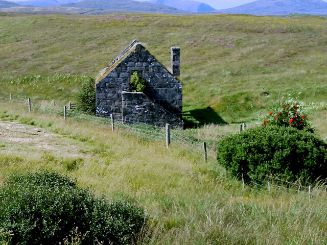
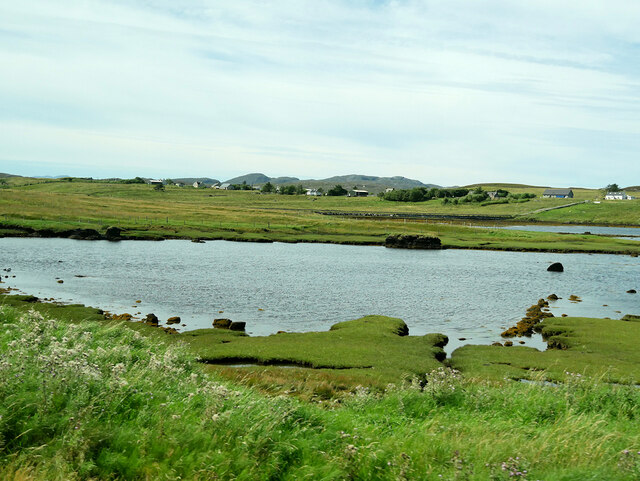
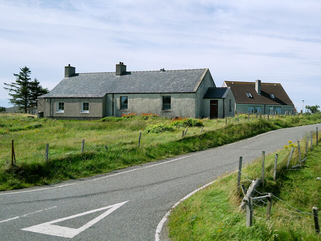
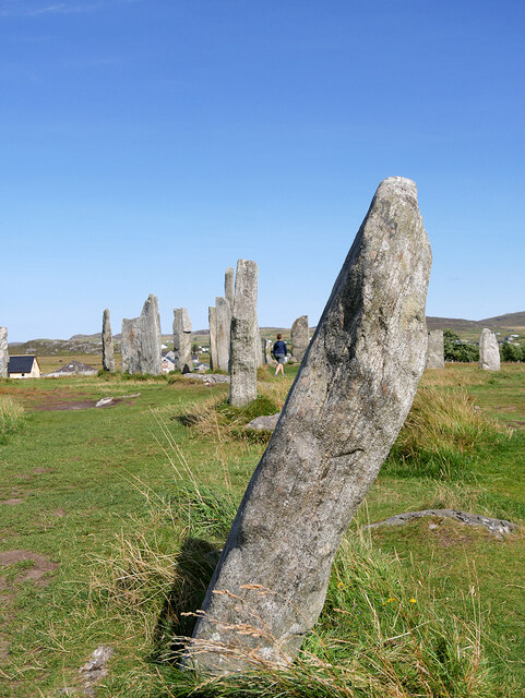
Sgeir an Eoin Images

Images are sourced within 2km of 58.214041/-6.7475829 or Grid Reference NB2134. Thanks to Geograph Open Source API. All images are credited.

Road to the Standing Stones The Calanais (Callanish) Stones are situated on the western coast of the island of Leodhas (Lewis) in na h-Eileanan an Iar (the Western Isles or Outer Hebrides). Their remote location has probably helped with preventing their destruction in earlier times. 
There are three groups of stones (I, II and III) in the immediate vicinity, with a further seventeen (IV to VIII, VIIIa to XIX) labelled sites and numerous others with no Roman numeral suffix. Of these multitude of sites the first group is the most extensive, famous and important. 
It is estimated, as a result of excavation, that the stones were set in place between 2900 and 2600 BC - or nearly five thousand years ago. This means that they predate the main ring at Stonehenge, and are slightly older than the Great Pyramid at Giza, for example.
This date places them in the Neolithic (New Stone Age) period.

Calanais / Callanish I - Clachan Chalanais or Tursachan Chalanais 
Calanais I is more complex than most surviving stone rings (which tend to be simply circular) as, looking down on it from above, it appears more like a Celtic Cross - i.e. a cross with a circle around the intersection point. It is not yet ascertained whether the cross and the circle were erected at the same time, or the cross added later. At the heart of the stones was a tomb, long since opened and emptied; but this tomb is thought to be a later addition, so was not the original reason for the stones.
Bronze Age (which immediately followed the Neolithic) remnants found nearby, indicate that the site continued in use for centuries, but it was eventually abandoned, and between 1000BC and 500BC became enveloped in a peat mound, such that their significance was not apparent for most of the modern era. It was not until the peat was removed in 1857 that their importance and grandeur was  appreciated.
see <a href="https://www.geograph.org.uk/photo/2597213">NB2133 : Calanais / Callanish I - General View</a>
see also <span class="nowrap"><a title="http://www.megalithic.co.uk/article.php?sid=27091" rel="nofollow ugc noopener" href="http://www.megalithic.co.uk/article.php?sid=27091">Link</a><img style="margin-left:2px;" alt="External link" title="External link - shift click to open in new window" src="https://s1.geograph.org.uk/img/external.png" width="10" height="10"/></span>
and <span class="nowrap"><a title="http://canmore.rcahms.gov.uk/en/site/4156/details/lewis+callanish" rel="nofollow ugc noopener" href="http://canmore.rcahms.gov.uk/en/site/4156/details/lewis+callanish">Link</a><img style="margin-left:2px;" alt="External link" title="External link - shift click to open in new window" src="https://s1.geograph.org.uk/img/external.png" width="10" height="10"/></span>

Calanais / Callanish II - Cnoc Ceann a' Gharaidh
The least extensive of the three groups of stones, Calanais II contains just five stones from what is thought to be an original ten stones with an 11th outlying stone. They are arranged in a slightly flattened circle (an ellipse) with major/minor axes of 21/19m (69/62 ft) They are of a similar date to Calanais I
see <a href="https://www.geograph.org.uk/photo/2597219">NB2232 : Calanais / Callanish II</a>
see also <span class="nowrap"><a title="http://www.megalithic.co.uk/article.php?sid=30" rel="nofollow ugc noopener" href="http://www.megalithic.co.uk/article.php?sid=30">Link</a><img style="margin-left:2px;" alt="External link" title="External link - shift click to open in new window" src="https://s1.geograph.org.uk/img/external.png" width="10" height="10"/></span>
and <span class="nowrap"><a title="http://canmore.rcahms.gov.uk/en/site/4169/details/lewis+callanish+tursachan" rel="nofollow ugc noopener" href="http://canmore.rcahms.gov.uk/en/site/4169/details/lewis+callanish+tursachan">Link</a><img style="margin-left:2px;" alt="External link" title="External link - shift click to open in new window" src="https://s1.geograph.org.uk/img/external.png" width="10" height="10"/></span>

Calanais / Callanish III - Cnoc Filibhir Bheag
Calanais III is more extensive than CII having seventeen extant stones. These are arranged as two concentric ellipses. They are a short walk over marshy ground from CII and are the first group to be encountered when driving westwards to Callanish.
see <a href="https://www.geograph.org.uk/photo/2597236">NB2232 : Calanais / Callanish III - General View</a>
see also <span class="nowrap"><a title="http://www.megalithic.co.uk/article.php?sid=31" rel="nofollow ugc noopener" href="http://www.megalithic.co.uk/article.php?sid=31">Link</a><img style="margin-left:2px;" alt="External link" title="External link - shift click to open in new window" src="https://s1.geograph.org.uk/img/external.png" width="10" height="10"/></span>
and <span class="nowrap"><a title="http://canmore.rcahms.gov.uk/en/site/4167/details/lewis+callanish+cnoc+fillibhir+bheag+tursachan" rel="nofollow ugc noopener" href="http://canmore.rcahms.gov.uk/en/site/4167/details/lewis+callanish+cnoc+fillibhir+bheag+tursachan">Link</a><img style="margin-left:2px;" alt="External link" title="External link - shift click to open in new window" src="https://s1.geograph.org.uk/img/external.png" width="10" height="10"/></span>

Calanais IV to Calanais XIX 
This is a list of the other seventeen (17 rather than 16 as there is VIII and VIIIa) "Calanais / Callanish" sites - some quite some distance from I, II and III
I have tried to find map references, photos and hyperlinks for each site, but I have not personally verified any of the following:
IV    - Ceann Hulavig (stone circle) NB22993041 - see <a href="https://www.geograph.org.uk/photo/1258326">NB2330 : Stone Circle at Ceann Hulavig (Callanish IV)</a>, <span class="nowrap"><a title="http://www.megalithic.co.uk/article.php?sid=32" rel="nofollow ugc noopener" href="http://www.megalithic.co.uk/article.php?sid=32">Link</a><img style="margin-left:2px;" alt="External link" title="External link - shift click to open in new window" src="https://s1.geograph.org.uk/img/external.png" width="10" height="10"/></span> (Photo) and <span class="nowrap"><a title="http://canmore.rcahms.gov.uk/en/site/4170/details/lewis+garynahine+tursachan" rel="nofollow ugc noopener" href="http://canmore.rcahms.gov.uk/en/site/4170/details/lewis+garynahine+tursachan">Link</a><img style="margin-left:2px;" alt="External link" title="External link - shift click to open in new window" src="https://s1.geograph.org.uk/img/external.png" width="10" height="10"/></span>
V     - Garynahine, Àirigh nam Bidearan (stone alignment) NB23442988 see <span class="nowrap"><a title="http://www.megalithic.co.uk/article.php?sid=33" rel="nofollow ugc noopener" href="http://www.megalithic.co.uk/article.php?sid=33">Link</a><img style="margin-left:2px;" alt="External link" title="External link - shift click to open in new window" src="https://s1.geograph.org.uk/img/external.png" width="10" height="10"/></span> (Photo) and <span class="nowrap"><a title="http://canmore.rcahms.gov.uk/en/site/4143/details/lewis+garynahine+airidh+nam+bidearan+tursachan" rel="nofollow ugc noopener" href="http://canmore.rcahms.gov.uk/en/site/4143/details/lewis+garynahine+airidh+nam+bidearan+tursachan">Link</a><img style="margin-left:2px;" alt="External link" title="External link - shift click to open in new window" src="https://s1.geograph.org.uk/img/external.png" width="10" height="10"/></span>
VI    - Cùl a' Chleit (stone circle) NB24663034 see <span class="nowrap"><a title="http://www.megalithic.co.uk/article.php?sid=481" rel="nofollow ugc noopener" href="http://www.megalithic.co.uk/article.php?sid=481">Link</a><img style="margin-left:2px;" alt="External link" title="External link - shift click to open in new window" src="https://s1.geograph.org.uk/img/external.png" width="10" height="10"/></span> (Photos) and <span class="nowrap"><a title="http://canmore.rcahms.gov.uk/en/site/4173/details/lewis+cul+a+chleit" rel="nofollow ugc noopener" href="http://canmore.rcahms.gov.uk/en/site/4173/details/lewis+cul+a+chleit">Link</a><img style="margin-left:2px;" alt="External link" title="External link - shift click to open in new window" src="https://s1.geograph.org.uk/img/external.png" width="10" height="10"/></span>
VII   - Cnoc Dubh (aka Cnoc a' Bhotha) NB23203019 (ancient shieling) - see <span class="nowrap"><a title="http://www.megalithic.co.uk/modules.php?op=modload&name=a312&file=index&do=showpic&pid=10938" rel="nofollow ugc noopener" href="http://www.megalithic.co.uk/modules.php?op=modload&name=a312&file=index&do=showpic&pid=10938">Link</a><img style="margin-left:2px;" alt="External link" title="External link - shift click to open in new window" src="https://s1.geograph.org.uk/img/external.png" width="10" height="10"/></span> (Photo) and <span class="nowrap"><a title="http://canmore.rcahms.gov.uk/en/site/4175/details/lewis+cnoc+dubh" rel="nofollow ugc noopener" href="http://canmore.rcahms.gov.uk/en/site/4175/details/lewis+cnoc+dubh">Link</a><img style="margin-left:2px;" alt="External link" title="External link - shift click to open in new window" src="https://s1.geograph.org.uk/img/external.png" width="10" height="10"/></span>
VIII   - Tursachan (semicircular cliff-top monument on Great Berneray) NB16443425 see <a href="https://www.geograph.org.uk/photo/217274">NB1634 : Standing Stones</a>, <span class="nowrap"><a title="http://www.megalithic.co.uk/article.php?sid=34" rel="nofollow ugc noopener" href="http://www.megalithic.co.uk/article.php?sid=34">Link</a><img style="margin-left:2px;" alt="External link" title="External link - shift click to open in new window" src="https://s1.geograph.org.uk/img/external.png" width="10" height="10"/></span> (Photo) and <span class="nowrap"><a title="http://canmore.rcahms.gov.uk/en/site/4112/details/great+bernera+tursachan+barraglom" rel="nofollow ugc noopener" href="http://canmore.rcahms.gov.uk/en/site/4112/details/great+bernera+tursachan+barraglom">Link</a><img style="margin-left:2px;" alt="External link" title="External link - shift click to open in new window" src="https://s1.geograph.org.uk/img/external.png" width="10" height="10"/></span>
VIIIa - Àird a' Chaolais (standing stone) facing Great Bernera NB16483407 (?) see <span class="nowrap"><a title="http://canmore.rcahms.gov.uk/en/site/4116/details/lewis+aird+a+chaolais" rel="nofollow ugc noopener" href="http://canmore.rcahms.gov.uk/en/site/4116/details/lewis+aird+a+chaolais">Link</a><img style="margin-left:2px;" alt="External link" title="External link - shift click to open in new window" src="https://s1.geograph.org.uk/img/external.png" width="10" height="10"/></span>
IX    - Àirigh nam Bidearan (recumbent stones) NB23382975 see <span class="nowrap"><a title="http://www.megalithic.co.uk/article.php?sid=564903441" rel="nofollow ugc noopener" href="http://www.megalithic.co.uk/article.php?sid=564903441">Link</a><img style="margin-left:2px;" alt="External link" title="External link - shift click to open in new window" src="https://s1.geograph.org.uk/img/external.png" width="10" height="10"/></span> (Photo) and <span class="nowrap"><a title="http://canmore.rcahms.gov.uk/en/site/4144/details/lewis+airigh+nam+bidearan" rel="nofollow ugc noopener" href="http://canmore.rcahms.gov.uk/en/site/4144/details/lewis+airigh+nam+bidearan">Link</a><img style="margin-left:2px;" alt="External link" title="External link - shift click to open in new window" src="https://s1.geograph.org.uk/img/external.png" width="10" height="10"/></span>
X     - Na Dromannan {Druim Nan Eun} (Cnoc a Charnain Mhoir & Bhig) (stone piles & quarry) NB22973362 see <span class="nowrap"><a title="http://www.megalithic.co.uk/article.php?sid=274071080" rel="nofollow ugc noopener" href="http://www.megalithic.co.uk/article.php?sid=274071080">Link</a><img style="margin-left:2px;" alt="External link" title="External link - shift click to open in new window" src="https://s1.geograph.org.uk/img/external.png" width="10" height="10"/></span> (Photo) and <span class="nowrap"><a title="http://canmore.rcahms.gov.uk/en/site/4172/details/lewis+druim+nan+eum" rel="nofollow ugc noopener" href="http://canmore.rcahms.gov.uk/en/site/4172/details/lewis+druim+nan+eum">Link</a><img style="margin-left:2px;" alt="External link" title="External link - shift click to open in new window" src="https://s1.geograph.org.uk/img/external.png" width="10" height="10"/></span> 
XI    - Beinn Bheag (various stones) NB22233569 see <span class="nowrap"><a title="http://www.megalithic.co.uk/article.php?sid=479" rel="nofollow ugc noopener" href="http://www.megalithic.co.uk/article.php?sid=479">Link</a><img style="margin-left:2px;" alt="External link" title="External link - shift click to open in new window" src="https://s1.geograph.org.uk/img/external.png" width="10" height="10"/></span> and <span class="nowrap"><a title="http://canmore.rcahms.gov.uk/en/site/4151/details/lewis+beinn+bheag" rel="nofollow ugc noopener" href="http://canmore.rcahms.gov.uk/en/site/4151/details/lewis+beinn+bheag">Link</a><img style="margin-left:2px;" alt="External link" title="External link - shift click to open in new window" src="https://s1.geograph.org.uk/img/external.png" width="10" height="10"/></span>
XII   - Stonefield (Breascleit) (standing stone(s)) NB21553496 see <span class="nowrap"><a title="http://www.megalithic.co.uk/article.php?sid=2235" rel="nofollow ugc noopener" href="http://www.megalithic.co.uk/article.php?sid=2235">Link</a><img style="margin-left:2px;" alt="External link" title="External link - shift click to open in new window" src="https://s1.geograph.org.uk/img/external.png" width="10" height="10"/></span> (Photo) and  <span class="nowrap"><a title="http://canmore.rcahms.gov.uk/en/site/4171/details/lewis+stonefield" rel="nofollow ugc noopener" href="http://canmore.rcahms.gov.uk/en/site/4171/details/lewis+stonefield">Link</a><img style="margin-left:2px;" alt="External link" title="External link - shift click to open in new window" src="https://s1.geograph.org.uk/img/external.png" width="10" height="10"/></span> see also <a href="https://www.geograph.org.uk/photo/485894">NB2134 : Breascleit Cairn</a>
XIII  - Sgeir nan Each (stone setting) NB215341 {not shown on OS maps} see <span class="nowrap"><a title="http://canmore.rcahms.gov.uk/en/site/4157/details/lewis+sgeir+nan+each" rel="nofollow ugc noopener" href="http://canmore.rcahms.gov.uk/en/site/4157/details/lewis+sgeir+nan+each">Link</a><img style="margin-left:2px;" alt="External link" title="External link - shift click to open in new window" src="https://s1.geograph.org.uk/img/external.png" width="10" height="10"/></span>
XIV   - Cnoc Sgeir na h-Uidhe (stones) NB22773298 {opposite side of A858 to Cal.III} see <span class="nowrap"><a title="http://www.megalithic.co.uk/article.php?sid=1664223577" rel="nofollow ugc noopener" href="http://www.megalithic.co.uk/article.php?sid=1664223577">Link</a><img style="margin-left:2px;" alt="External link" title="External link - shift click to open in new window" src="https://s1.geograph.org.uk/img/external.png" width="10" height="10"/></span> (Photo) and <span class="nowrap"><a title="http://canmore.rcahms.gov.uk/en/site/4159/details/lewis+cnoc+sgeir+na+h+uidhe" rel="nofollow ugc noopener" href="http://canmore.rcahms.gov.uk/en/site/4159/details/lewis+cnoc+sgeir+na+h+uidhe">Link</a><img style="margin-left:2px;" alt="External link" title="External link - shift click to open in new window" src="https://s1.geograph.org.uk/img/external.png" width="10" height="10"/></span>
XV    - Àirigh Mhaoldonuich (standing stone) NB17753458 see <span class="nowrap"><a title="http://canmore.rcahms.gov.uk/en/site/72849/details/great+bernera+airigh+mhaoldonuich" rel="nofollow ugc noopener" href="http://canmore.rcahms.gov.uk/en/site/72849/details/great+bernera+airigh+mhaoldonuich">Link</a><img style="margin-left:2px;" alt="External link" title="External link - shift click to open in new window" src="https://s1.geograph.org.uk/img/external.png" width="10" height="10"/></span>
XVI   - Cliacabhadh (standing stone + other stones) NB213338 {North of Calanais village, not shown on OS maps} see <span class="nowrap"><a title="http://www.megalithic.co.uk/article.php?sid=2236" rel="nofollow ugc noopener" href="http://www.megalithic.co.uk/article.php?sid=2236">Link</a><img style="margin-left:2px;" alt="External link" title="External link - shift click to open in new window" src="https://s1.geograph.org.uk/img/external.png" width="10" height="10"/></span> and <span class="nowrap"><a title="http://canmore.rcahms.gov.uk/en/site/4160/details/lewis+callanish+cliacabhadh" rel="nofollow ugc noopener" href="http://canmore.rcahms.gov.uk/en/site/4160/details/lewis+callanish+cliacabhadh">Link</a><img style="margin-left:2px;" alt="External link" title="External link - shift click to open in new window" src="https://s1.geograph.org.uk/img/external.png" width="10" height="10"/></span>
XVII  - Druim na h-Aon Choich (standing stone?) NB23703191 see <span class="nowrap"><a title="http://www.megalithic.co.uk/article.php?sid=1116628316" rel="nofollow ugc noopener" href="http://www.megalithic.co.uk/article.php?sid=1116628316">Link</a><img style="margin-left:2px;" alt="External link" title="External link - shift click to open in new window" src="https://s1.geograph.org.uk/img/external.png" width="10" height="10"/></span> (Photo) and <span class="nowrap"><a title="http://canmore.rcahms.gov.uk/en/site/4161/details/lewis+druim+na+h+aon+choich" rel="nofollow ugc noopener" href="http://canmore.rcahms.gov.uk/en/site/4161/details/lewis+druim+na+h+aon+choich">Link</a><img style="margin-left:2px;" alt="External link" title="External link - shift click to open in new window" src="https://s1.geograph.org.uk/img/external.png" width="10" height="10"/></span>
XVIII - Loch Crogach (standing stone ?) NB24402923 see <span class="nowrap"><a title="http://canmore.rcahms.gov.uk/en/site/4145/details/lewis+loch+crogach" rel="nofollow ugc noopener" href="http://canmore.rcahms.gov.uk/en/site/4145/details/lewis+loch+crogach">Link</a><img style="margin-left:2px;" alt="External link" title="External link - shift click to open in new window" src="https://s1.geograph.org.uk/img/external.png" width="10" height="10"/></span>
XIX   - Buaile Chruaidh (standing stone ?) NB21813314 see <span class="nowrap"><a title="http://www.megalithic.co.uk/article.php?sid=756578605" rel="nofollow ugc noopener" href="http://www.megalithic.co.uk/article.php?sid=756578605">Link</a><img style="margin-left:2px;" alt="External link" title="External link - shift click to open in new window" src="https://s1.geograph.org.uk/img/external.png" width="10" height="10"/></span> (Photo) and <span class="nowrap"><a title="http://canmore.rcahms.gov.uk/en/site/4163/details/lewis+buaile+chruaidh" rel="nofollow ugc noopener" href="http://canmore.rcahms.gov.uk/en/site/4163/details/lewis+buaile+chruaidh">Link</a><img style="margin-left:2px;" alt="External link" title="External link - shift click to open in new window" src="https://s1.geograph.org.uk/img/external.png" width="10" height="10"/></span>
Road to the Standing Stones
The Calanais (Callanish) Stones are situated on the western coast of the island of Leodhas (Lewis) in na h-Eileanan an Iar (the Western Isles or Outer Hebrides). Their remote location has probably helped with preventing their destruction in earlier times. There are three groups of stones (I, II and III) in the immediate vicinity, with a further seventeen (IV to VIII, VIIIa to XIX) labelled sites and numerous others with no Roman numeral suffix. Of these multitude of sites the first group is the most extensive, famous and important. It is estimated, as a result of excavation, that the stones were set in place between 2900 and 2600 BC - or nearly five thousand years ago. This means that they predate the main ring at Stonehenge, and are slightly older than the Great Pyramid at Giza, for example. This date places them in the Neolithic (New Stone Age) period. Calanais / Callanish I - Clachan Chalanais or Tursachan Chalanais Calanais I is more complex than most surviving stone rings (which tend to be simply circular) as, looking down on it from above, it appears more like a Celtic Cross - i.e. a cross with a circle around the intersection point. It is not yet ascertained whether the cross and the circle were erected at the same time, or the cross added later. At the heart of the stones was a tomb, long since opened and emptied; but this tomb is thought to be a later addition, so was not the original reason for the stones. Bronze Age (which immediately followed the Neolithic) remnants found nearby, indicate that the site continued in use for centuries, but it was eventually abandoned, and between 1000BC and 500BC became enveloped in a peat mound, such that their significance was not apparent for most of the modern era. It was not until the peat was removed in 1857 that their importance and grandeur was appreciated. see NB2133 : Calanais / Callanish I - General View see also LinkExternal link and LinkExternal link Calanais / Callanish II - Cnoc Ceann a' Gharaidh The least extensive of the three groups of stones, Calanais II contains just five stones from what is thought to be an original ten stones with an 11th outlying stone. They are arranged in a slightly flattened circle (an ellipse) with major/minor axes of 21/19m (69/62 ft) They are of a similar date to Calanais I see NB2232 : Calanais / Callanish II see also LinkExternal link and LinkExternal link Calanais / Callanish III - Cnoc Filibhir Bheag Calanais III is more extensive than CII having seventeen extant stones. These are arranged as two concentric ellipses. They are a short walk over marshy ground from CII and are the first group to be encountered when driving westwards to Callanish. see NB2232 : Calanais / Callanish III - General View see also LinkExternal link and LinkExternal link Calanais IV to Calanais XIX This is a list of the other seventeen (17 rather than 16 as there is VIII and VIIIa) "Calanais / Callanish" sites - some quite some distance from I, II and III I have tried to find map references, photos and hyperlinks for each site, but I have not personally verified any of the following: IV - Ceann Hulavig (stone circle) NB22993041 - see NB2330 : Stone Circle at Ceann Hulavig (Callanish IV), LinkExternal link (Photo) and LinkExternal link V - Garynahine, Àirigh nam Bidearan (stone alignment) NB23442988 see LinkExternal link (Photo) and LinkExternal link VI - Cùl a' Chleit (stone circle) NB24663034 see LinkExternal link (Photos) and LinkExternal link VII - Cnoc Dubh (aka Cnoc a' Bhotha) NB23203019 (ancient shieling) - see LinkExternal link (Photo) and LinkExternal link VIII - Tursachan (semicircular cliff-top monument on Great Berneray) NB16443425 see NB1634 : Standing Stones, LinkExternal link (Photo) and LinkExternal link VIIIa - Àird a' Chaolais (standing stone) facing Great Bernera NB16483407 (?) see LinkExternal link IX - Àirigh nam Bidearan (recumbent stones) NB23382975 see LinkExternal link (Photo) and LinkExternal link X - Na Dromannan {Druim Nan Eun} (Cnoc a Charnain Mhoir & Bhig) (stone piles & quarry) NB22973362 see LinkExternal link (Photo) and LinkExternal link XI - Beinn Bheag (various stones) NB22233569 see LinkExternal link and LinkExternal link XII - Stonefield (Breascleit) (standing stone(s)) NB21553496 see LinkExternal link (Photo) and LinkExternal link see also NB2134 : Breascleit Cairn XIII - Sgeir nan Each (stone setting) NB215341 {not shown on OS maps} see LinkExternal link XIV - Cnoc Sgeir na h-Uidhe (stones) NB22773298 {opposite side of A858 to Cal.III} see LinkExternal link (Photo) and LinkExternal link XV - Àirigh Mhaoldonuich (standing stone) NB17753458 see LinkExternal link XVI - Cliacabhadh (standing stone + other stones) NB213338 {North of Calanais village, not shown on OS maps} see LinkExternal link and LinkExternal link XVII - Druim na h-Aon Choich (standing stone?) NB23703191 see LinkExternal link (Photo) and LinkExternal link XVIII - Loch Crogach (standing stone ?) NB24402923 see LinkExternal link XIX - Buaile Chruaidh (standing stone ?) NB21813314 see LinkExternal link (Photo) and LinkExternal link
Not very impressive stones
Calanais Stones The Calanais (Callanish) Stones are situated on the western coast of the island of Leodhas (Lewis) in na h-Eileanan an Iar (the Western Isles or Outer Hebrides). Their remote location has probably helped with preventing their destruction in earlier times. 
There are three groups of stones (I, II and III) in the immediate vicinity, with a further seventeen (IV to VIII, VIIIa to XIX) labelled sites and numerous others with no Roman numeral suffix. Of these multitude of sites the first group is the most extensive, famous and important. 
It is estimated, as a result of excavation, that the stones were set in place between 2900 and 2600 BC - or nearly five thousand years ago. This means that they predate the main ring at Stonehenge, and are slightly older than the Great Pyramid at Giza, for example.
This date places them in the Neolithic (New Stone Age) period.

Calanais / Callanish I - Clachan Chalanais or Tursachan Chalanais 
Calanais I is more complex than most surviving stone rings (which tend to be simply circular) as, looking down on it from above, it appears more like a Celtic Cross - i.e. a cross with a circle around the intersection point. It is not yet ascertained whether the cross and the circle were erected at the same time, or the cross added later. At the heart of the stones was a tomb, long since opened and emptied; but this tomb is thought to be a later addition, so was not the original reason for the stones.
Bronze Age (which immediately followed the Neolithic) remnants found nearby, indicate that the site continued in use for centuries, but it was eventually abandoned, and between 1000BC and 500BC became enveloped in a peat mound, such that their significance was not apparent for most of the modern era. It was not until the peat was removed in 1857 that their importance and grandeur was  appreciated.
see <a href="https://www.geograph.org.uk/photo/2597213">NB2133 : Calanais / Callanish I - General View</a>
see also <span class="nowrap"><a title="http://www.megalithic.co.uk/article.php?sid=27091" rel="nofollow ugc noopener" href="http://www.megalithic.co.uk/article.php?sid=27091">Link</a><img style="margin-left:2px;" alt="External link" title="External link - shift click to open in new window" src="https://s1.geograph.org.uk/img/external.png" width="10" height="10"/></span>
and <span class="nowrap"><a title="http://canmore.rcahms.gov.uk/en/site/4156/details/lewis+callanish" rel="nofollow ugc noopener" href="http://canmore.rcahms.gov.uk/en/site/4156/details/lewis+callanish">Link</a><img style="margin-left:2px;" alt="External link" title="External link - shift click to open in new window" src="https://s1.geograph.org.uk/img/external.png" width="10" height="10"/></span>

Calanais / Callanish II - Cnoc Ceann a' Gharaidh
The least extensive of the three groups of stones, Calanais II contains just five stones from what is thought to be an original ten stones with an 11th outlying stone. They are arranged in a slightly flattened circle (an ellipse) with major/minor axes of 21/19m (69/62 ft) They are of a similar date to Calanais I
see <a href="https://www.geograph.org.uk/photo/2597219">NB2232 : Calanais / Callanish II</a>
see also <span class="nowrap"><a title="http://www.megalithic.co.uk/article.php?sid=30" rel="nofollow ugc noopener" href="http://www.megalithic.co.uk/article.php?sid=30">Link</a><img style="margin-left:2px;" alt="External link" title="External link - shift click to open in new window" src="https://s1.geograph.org.uk/img/external.png" width="10" height="10"/></span>
and <span class="nowrap"><a title="http://canmore.rcahms.gov.uk/en/site/4169/details/lewis+callanish+tursachan" rel="nofollow ugc noopener" href="http://canmore.rcahms.gov.uk/en/site/4169/details/lewis+callanish+tursachan">Link</a><img style="margin-left:2px;" alt="External link" title="External link - shift click to open in new window" src="https://s1.geograph.org.uk/img/external.png" width="10" height="10"/></span>

Calanais / Callanish III - Cnoc Filibhir Bheag
Calanais III is more extensive than CII having seventeen extant stones. These are arranged as two concentric ellipses. They are a short walk over marshy ground from CII and are the first group to be encountered when driving westwards to Callanish.
see <a href="https://www.geograph.org.uk/photo/2597236">NB2232 : Calanais / Callanish III - General View</a>
see also <span class="nowrap"><a title="http://www.megalithic.co.uk/article.php?sid=31" rel="nofollow ugc noopener" href="http://www.megalithic.co.uk/article.php?sid=31">Link</a><img style="margin-left:2px;" alt="External link" title="External link - shift click to open in new window" src="https://s1.geograph.org.uk/img/external.png" width="10" height="10"/></span>
and <span class="nowrap"><a title="http://canmore.rcahms.gov.uk/en/site/4167/details/lewis+callanish+cnoc+fillibhir+bheag+tursachan" rel="nofollow ugc noopener" href="http://canmore.rcahms.gov.uk/en/site/4167/details/lewis+callanish+cnoc+fillibhir+bheag+tursachan">Link</a><img style="margin-left:2px;" alt="External link" title="External link - shift click to open in new window" src="https://s1.geograph.org.uk/img/external.png" width="10" height="10"/></span>

Calanais IV to Calanais XIX 
This is a list of the other seventeen (17 rather than 16 as there is VIII and VIIIa) "Calanais / Callanish" sites - some quite some distance from I, II and III
I have tried to find map references, photos and hyperlinks for each site, but I have not personally verified any of the following:
IV    - Ceann Hulavig (stone circle) NB22993041 - see <a href="https://www.geograph.org.uk/photo/1258326">NB2330 : Stone Circle at Ceann Hulavig (Callanish IV)</a>, <span class="nowrap"><a title="http://www.megalithic.co.uk/article.php?sid=32" rel="nofollow ugc noopener" href="http://www.megalithic.co.uk/article.php?sid=32">Link</a><img style="margin-left:2px;" alt="External link" title="External link - shift click to open in new window" src="https://s1.geograph.org.uk/img/external.png" width="10" height="10"/></span> (Photo) and <span class="nowrap"><a title="http://canmore.rcahms.gov.uk/en/site/4170/details/lewis+garynahine+tursachan" rel="nofollow ugc noopener" href="http://canmore.rcahms.gov.uk/en/site/4170/details/lewis+garynahine+tursachan">Link</a><img style="margin-left:2px;" alt="External link" title="External link - shift click to open in new window" src="https://s1.geograph.org.uk/img/external.png" width="10" height="10"/></span>
V     - Garynahine, Àirigh nam Bidearan (stone alignment) NB23442988 see <span class="nowrap"><a title="http://www.megalithic.co.uk/article.php?sid=33" rel="nofollow ugc noopener" href="http://www.megalithic.co.uk/article.php?sid=33">Link</a><img style="margin-left:2px;" alt="External link" title="External link - shift click to open in new window" src="https://s1.geograph.org.uk/img/external.png" width="10" height="10"/></span> (Photo) and <span class="nowrap"><a title="http://canmore.rcahms.gov.uk/en/site/4143/details/lewis+garynahine+airidh+nam+bidearan+tursachan" rel="nofollow ugc noopener" href="http://canmore.rcahms.gov.uk/en/site/4143/details/lewis+garynahine+airidh+nam+bidearan+tursachan">Link</a><img style="margin-left:2px;" alt="External link" title="External link - shift click to open in new window" src="https://s1.geograph.org.uk/img/external.png" width="10" height="10"/></span>
VI    - Cùl a' Chleit (stone circle) NB24663034 see <span class="nowrap"><a title="http://www.megalithic.co.uk/article.php?sid=481" rel="nofollow ugc noopener" href="http://www.megalithic.co.uk/article.php?sid=481">Link</a><img style="margin-left:2px;" alt="External link" title="External link - shift click to open in new window" src="https://s1.geograph.org.uk/img/external.png" width="10" height="10"/></span> (Photos) and <span class="nowrap"><a title="http://canmore.rcahms.gov.uk/en/site/4173/details/lewis+cul+a+chleit" rel="nofollow ugc noopener" href="http://canmore.rcahms.gov.uk/en/site/4173/details/lewis+cul+a+chleit">Link</a><img style="margin-left:2px;" alt="External link" title="External link - shift click to open in new window" src="https://s1.geograph.org.uk/img/external.png" width="10" height="10"/></span>
VII   - Cnoc Dubh (aka Cnoc a' Bhotha) NB23203019 (ancient shieling) - see <span class="nowrap"><a title="http://www.megalithic.co.uk/modules.php?op=modload&name=a312&file=index&do=showpic&pid=10938" rel="nofollow ugc noopener" href="http://www.megalithic.co.uk/modules.php?op=modload&name=a312&file=index&do=showpic&pid=10938">Link</a><img style="margin-left:2px;" alt="External link" title="External link - shift click to open in new window" src="https://s1.geograph.org.uk/img/external.png" width="10" height="10"/></span> (Photo) and <span class="nowrap"><a title="http://canmore.rcahms.gov.uk/en/site/4175/details/lewis+cnoc+dubh" rel="nofollow ugc noopener" href="http://canmore.rcahms.gov.uk/en/site/4175/details/lewis+cnoc+dubh">Link</a><img style="margin-left:2px;" alt="External link" title="External link - shift click to open in new window" src="https://s1.geograph.org.uk/img/external.png" width="10" height="10"/></span>
VIII   - Tursachan (semicircular cliff-top monument on Great Berneray) NB16443425 see <a href="https://www.geograph.org.uk/photo/217274">NB1634 : Standing Stones</a>, <span class="nowrap"><a title="http://www.megalithic.co.uk/article.php?sid=34" rel="nofollow ugc noopener" href="http://www.megalithic.co.uk/article.php?sid=34">Link</a><img style="margin-left:2px;" alt="External link" title="External link - shift click to open in new window" src="https://s1.geograph.org.uk/img/external.png" width="10" height="10"/></span> (Photo) and <span class="nowrap"><a title="http://canmore.rcahms.gov.uk/en/site/4112/details/great+bernera+tursachan+barraglom" rel="nofollow ugc noopener" href="http://canmore.rcahms.gov.uk/en/site/4112/details/great+bernera+tursachan+barraglom">Link</a><img style="margin-left:2px;" alt="External link" title="External link - shift click to open in new window" src="https://s1.geograph.org.uk/img/external.png" width="10" height="10"/></span>
VIIIa - Àird a' Chaolais (standing stone) facing Great Bernera NB16483407 (?) see <span class="nowrap"><a title="http://canmore.rcahms.gov.uk/en/site/4116/details/lewis+aird+a+chaolais" rel="nofollow ugc noopener" href="http://canmore.rcahms.gov.uk/en/site/4116/details/lewis+aird+a+chaolais">Link</a><img style="margin-left:2px;" alt="External link" title="External link - shift click to open in new window" src="https://s1.geograph.org.uk/img/external.png" width="10" height="10"/></span>
IX    - Àirigh nam Bidearan (recumbent stones) NB23382975 see <span class="nowrap"><a title="http://www.megalithic.co.uk/article.php?sid=564903441" rel="nofollow ugc noopener" href="http://www.megalithic.co.uk/article.php?sid=564903441">Link</a><img style="margin-left:2px;" alt="External link" title="External link - shift click to open in new window" src="https://s1.geograph.org.uk/img/external.png" width="10" height="10"/></span> (Photo) and <span class="nowrap"><a title="http://canmore.rcahms.gov.uk/en/site/4144/details/lewis+airigh+nam+bidearan" rel="nofollow ugc noopener" href="http://canmore.rcahms.gov.uk/en/site/4144/details/lewis+airigh+nam+bidearan">Link</a><img style="margin-left:2px;" alt="External link" title="External link - shift click to open in new window" src="https://s1.geograph.org.uk/img/external.png" width="10" height="10"/></span>
X     - Na Dromannan {Druim Nan Eun} (Cnoc a Charnain Mhoir & Bhig) (stone piles & quarry) NB22973362 see <span class="nowrap"><a title="http://www.megalithic.co.uk/article.php?sid=274071080" rel="nofollow ugc noopener" href="http://www.megalithic.co.uk/article.php?sid=274071080">Link</a><img style="margin-left:2px;" alt="External link" title="External link - shift click to open in new window" src="https://s1.geograph.org.uk/img/external.png" width="10" height="10"/></span> (Photo) and <span class="nowrap"><a title="http://canmore.rcahms.gov.uk/en/site/4172/details/lewis+druim+nan+eum" rel="nofollow ugc noopener" href="http://canmore.rcahms.gov.uk/en/site/4172/details/lewis+druim+nan+eum">Link</a><img style="margin-left:2px;" alt="External link" title="External link - shift click to open in new window" src="https://s1.geograph.org.uk/img/external.png" width="10" height="10"/></span> 
XI    - Beinn Bheag (various stones) NB22233569 see <span class="nowrap"><a title="http://www.megalithic.co.uk/article.php?sid=479" rel="nofollow ugc noopener" href="http://www.megalithic.co.uk/article.php?sid=479">Link</a><img style="margin-left:2px;" alt="External link" title="External link - shift click to open in new window" src="https://s1.geograph.org.uk/img/external.png" width="10" height="10"/></span> and <span class="nowrap"><a title="http://canmore.rcahms.gov.uk/en/site/4151/details/lewis+beinn+bheag" rel="nofollow ugc noopener" href="http://canmore.rcahms.gov.uk/en/site/4151/details/lewis+beinn+bheag">Link</a><img style="margin-left:2px;" alt="External link" title="External link - shift click to open in new window" src="https://s1.geograph.org.uk/img/external.png" width="10" height="10"/></span>
XII   - Stonefield (Breascleit) (standing stone(s)) NB21553496 see <span class="nowrap"><a title="http://www.megalithic.co.uk/article.php?sid=2235" rel="nofollow ugc noopener" href="http://www.megalithic.co.uk/article.php?sid=2235">Link</a><img style="margin-left:2px;" alt="External link" title="External link - shift click to open in new window" src="https://s1.geograph.org.uk/img/external.png" width="10" height="10"/></span> (Photo) and  <span class="nowrap"><a title="http://canmore.rcahms.gov.uk/en/site/4171/details/lewis+stonefield" rel="nofollow ugc noopener" href="http://canmore.rcahms.gov.uk/en/site/4171/details/lewis+stonefield">Link</a><img style="margin-left:2px;" alt="External link" title="External link - shift click to open in new window" src="https://s1.geograph.org.uk/img/external.png" width="10" height="10"/></span> see also <a href="https://www.geograph.org.uk/photo/485894">NB2134 : Breascleit Cairn</a>
XIII  - Sgeir nan Each (stone setting) NB215341 {not shown on OS maps} see <span class="nowrap"><a title="http://canmore.rcahms.gov.uk/en/site/4157/details/lewis+sgeir+nan+each" rel="nofollow ugc noopener" href="http://canmore.rcahms.gov.uk/en/site/4157/details/lewis+sgeir+nan+each">Link</a><img style="margin-left:2px;" alt="External link" title="External link - shift click to open in new window" src="https://s1.geograph.org.uk/img/external.png" width="10" height="10"/></span>
XIV   - Cnoc Sgeir na h-Uidhe (stones) NB22773298 {opposite side of A858 to Cal.III} see <span class="nowrap"><a title="http://www.megalithic.co.uk/article.php?sid=1664223577" rel="nofollow ugc noopener" href="http://www.megalithic.co.uk/article.php?sid=1664223577">Link</a><img style="margin-left:2px;" alt="External link" title="External link - shift click to open in new window" src="https://s1.geograph.org.uk/img/external.png" width="10" height="10"/></span> (Photo) and <span class="nowrap"><a title="http://canmore.rcahms.gov.uk/en/site/4159/details/lewis+cnoc+sgeir+na+h+uidhe" rel="nofollow ugc noopener" href="http://canmore.rcahms.gov.uk/en/site/4159/details/lewis+cnoc+sgeir+na+h+uidhe">Link</a><img style="margin-left:2px;" alt="External link" title="External link - shift click to open in new window" src="https://s1.geograph.org.uk/img/external.png" width="10" height="10"/></span>
XV    - Àirigh Mhaoldonuich (standing stone) NB17753458 see <span class="nowrap"><a title="http://canmore.rcahms.gov.uk/en/site/72849/details/great+bernera+airigh+mhaoldonuich" rel="nofollow ugc noopener" href="http://canmore.rcahms.gov.uk/en/site/72849/details/great+bernera+airigh+mhaoldonuich">Link</a><img style="margin-left:2px;" alt="External link" title="External link - shift click to open in new window" src="https://s1.geograph.org.uk/img/external.png" width="10" height="10"/></span>
XVI   - Cliacabhadh (standing stone + other stones) NB213338 {North of Calanais village, not shown on OS maps} see <span class="nowrap"><a title="http://www.megalithic.co.uk/article.php?sid=2236" rel="nofollow ugc noopener" href="http://www.megalithic.co.uk/article.php?sid=2236">Link</a><img style="margin-left:2px;" alt="External link" title="External link - shift click to open in new window" src="https://s1.geograph.org.uk/img/external.png" width="10" height="10"/></span> and <span class="nowrap"><a title="http://canmore.rcahms.gov.uk/en/site/4160/details/lewis+callanish+cliacabhadh" rel="nofollow ugc noopener" href="http://canmore.rcahms.gov.uk/en/site/4160/details/lewis+callanish+cliacabhadh">Link</a><img style="margin-left:2px;" alt="External link" title="External link - shift click to open in new window" src="https://s1.geograph.org.uk/img/external.png" width="10" height="10"/></span>
XVII  - Druim na h-Aon Choich (standing stone?) NB23703191 see <span class="nowrap"><a title="http://www.megalithic.co.uk/article.php?sid=1116628316" rel="nofollow ugc noopener" href="http://www.megalithic.co.uk/article.php?sid=1116628316">Link</a><img style="margin-left:2px;" alt="External link" title="External link - shift click to open in new window" src="https://s1.geograph.org.uk/img/external.png" width="10" height="10"/></span> (Photo) and <span class="nowrap"><a title="http://canmore.rcahms.gov.uk/en/site/4161/details/lewis+druim+na+h+aon+choich" rel="nofollow ugc noopener" href="http://canmore.rcahms.gov.uk/en/site/4161/details/lewis+druim+na+h+aon+choich">Link</a><img style="margin-left:2px;" alt="External link" title="External link - shift click to open in new window" src="https://s1.geograph.org.uk/img/external.png" width="10" height="10"/></span>
XVIII - Loch Crogach (standing stone ?) NB24402923 see <span class="nowrap"><a title="http://canmore.rcahms.gov.uk/en/site/4145/details/lewis+loch+crogach" rel="nofollow ugc noopener" href="http://canmore.rcahms.gov.uk/en/site/4145/details/lewis+loch+crogach">Link</a><img style="margin-left:2px;" alt="External link" title="External link - shift click to open in new window" src="https://s1.geograph.org.uk/img/external.png" width="10" height="10"/></span>
XIX   - Buaile Chruaidh (standing stone ?) NB21813314 see <span class="nowrap"><a title="http://www.megalithic.co.uk/article.php?sid=756578605" rel="nofollow ugc noopener" href="http://www.megalithic.co.uk/article.php?sid=756578605">Link</a><img style="margin-left:2px;" alt="External link" title="External link - shift click to open in new window" src="https://s1.geograph.org.uk/img/external.png" width="10" height="10"/></span> (Photo) and <span class="nowrap"><a title="http://canmore.rcahms.gov.uk/en/site/4163/details/lewis+buaile+chruaidh" rel="nofollow ugc noopener" href="http://canmore.rcahms.gov.uk/en/site/4163/details/lewis+buaile+chruaidh">Link</a><img style="margin-left:2px;" alt="External link" title="External link - shift click to open in new window" src="https://s1.geograph.org.uk/img/external.png" width="10" height="10"/></span>
Calanais Stones
The Calanais (Callanish) Stones are situated on the western coast of the island of Leodhas (Lewis) in na h-Eileanan an Iar (the Western Isles or Outer Hebrides). Their remote location has probably helped with preventing their destruction in earlier times. There are three groups of stones (I, II and III) in the immediate vicinity, with a further seventeen (IV to VIII, VIIIa to XIX) labelled sites and numerous others with no Roman numeral suffix. Of these multitude of sites the first group is the most extensive, famous and important. It is estimated, as a result of excavation, that the stones were set in place between 2900 and 2600 BC - or nearly five thousand years ago. This means that they predate the main ring at Stonehenge, and are slightly older than the Great Pyramid at Giza, for example. This date places them in the Neolithic (New Stone Age) period. Calanais / Callanish I - Clachan Chalanais or Tursachan Chalanais Calanais I is more complex than most surviving stone rings (which tend to be simply circular) as, looking down on it from above, it appears more like a Celtic Cross - i.e. a cross with a circle around the intersection point. It is not yet ascertained whether the cross and the circle were erected at the same time, or the cross added later. At the heart of the stones was a tomb, long since opened and emptied; but this tomb is thought to be a later addition, so was not the original reason for the stones. Bronze Age (which immediately followed the Neolithic) remnants found nearby, indicate that the site continued in use for centuries, but it was eventually abandoned, and between 1000BC and 500BC became enveloped in a peat mound, such that their significance was not apparent for most of the modern era. It was not until the peat was removed in 1857 that their importance and grandeur was appreciated. see NB2133 : Calanais / Callanish I - General View see also LinkExternal link and LinkExternal link Calanais / Callanish II - Cnoc Ceann a' Gharaidh The least extensive of the three groups of stones, Calanais II contains just five stones from what is thought to be an original ten stones with an 11th outlying stone. They are arranged in a slightly flattened circle (an ellipse) with major/minor axes of 21/19m (69/62 ft) They are of a similar date to Calanais I see NB2232 : Calanais / Callanish II see also LinkExternal link and LinkExternal link Calanais / Callanish III - Cnoc Filibhir Bheag Calanais III is more extensive than CII having seventeen extant stones. These are arranged as two concentric ellipses. They are a short walk over marshy ground from CII and are the first group to be encountered when driving westwards to Callanish. see NB2232 : Calanais / Callanish III - General View see also LinkExternal link and LinkExternal link Calanais IV to Calanais XIX This is a list of the other seventeen (17 rather than 16 as there is VIII and VIIIa) "Calanais / Callanish" sites - some quite some distance from I, II and III I have tried to find map references, photos and hyperlinks for each site, but I have not personally verified any of the following: IV - Ceann Hulavig (stone circle) NB22993041 - see NB2330 : Stone Circle at Ceann Hulavig (Callanish IV), LinkExternal link (Photo) and LinkExternal link V - Garynahine, Àirigh nam Bidearan (stone alignment) NB23442988 see LinkExternal link (Photo) and LinkExternal link VI - Cùl a' Chleit (stone circle) NB24663034 see LinkExternal link (Photos) and LinkExternal link VII - Cnoc Dubh (aka Cnoc a' Bhotha) NB23203019 (ancient shieling) - see LinkExternal link (Photo) and LinkExternal link VIII - Tursachan (semicircular cliff-top monument on Great Berneray) NB16443425 see NB1634 : Standing Stones, LinkExternal link (Photo) and LinkExternal link VIIIa - Àird a' Chaolais (standing stone) facing Great Bernera NB16483407 (?) see LinkExternal link IX - Àirigh nam Bidearan (recumbent stones) NB23382975 see LinkExternal link (Photo) and LinkExternal link X - Na Dromannan {Druim Nan Eun} (Cnoc a Charnain Mhoir & Bhig) (stone piles & quarry) NB22973362 see LinkExternal link (Photo) and LinkExternal link XI - Beinn Bheag (various stones) NB22233569 see LinkExternal link and LinkExternal link XII - Stonefield (Breascleit) (standing stone(s)) NB21553496 see LinkExternal link (Photo) and LinkExternal link see also NB2134 : Breascleit Cairn XIII - Sgeir nan Each (stone setting) NB215341 {not shown on OS maps} see LinkExternal link XIV - Cnoc Sgeir na h-Uidhe (stones) NB22773298 {opposite side of A858 to Cal.III} see LinkExternal link (Photo) and LinkExternal link XV - Àirigh Mhaoldonuich (standing stone) NB17753458 see LinkExternal link XVI - Cliacabhadh (standing stone + other stones) NB213338 {North of Calanais village, not shown on OS maps} see LinkExternal link and LinkExternal link XVII - Druim na h-Aon Choich (standing stone?) NB23703191 see LinkExternal link (Photo) and LinkExternal link XVIII - Loch Crogach (standing stone ?) NB24402923 see LinkExternal link XIX - Buaile Chruaidh (standing stone ?) NB21813314 see LinkExternal link (Photo) and LinkExternal link
Standing Stones on Lewis The Calanais Standing Stones (or Callanish in its anglicised form) is a cruciform shaped stone circle near the village of Callanish (Gaelic: Calanais) on the west coast of Lewis. Erected 5000 years ago, in the late Neolithic era, they predate England’s famous Stonehenge monument. There is much mystery surrounding their inception, no one knows why the standing stones at Calanais were erected, but they were an important place for ritual activity for at least 2,000 years. The stones are all of the same rock type, namely the local Lewisian gneiss.
The site is managed by Historic Environment Scotland. There is The Calanais Stones Visitor Centre operated by Urras Nan Tursachan (The Standing Stones Trust).
Standing Stones on Lewis
The Calanais Standing Stones (or Callanish in its anglicised form) is a cruciform shaped stone circle near the village of Callanish (Gaelic: Calanais) on the west coast of Lewis. Erected 5000 years ago, in the late Neolithic era, they predate England’s famous Stonehenge monument. There is much mystery surrounding their inception, no one knows why the standing stones at Calanais were erected, but they were an important place for ritual activity for at least 2,000 years. The stones are all of the same rock type, namely the local Lewisian gneiss. The site is managed by Historic Environment Scotland. There is The Calanais Stones Visitor Centre operated by Urras Nan Tursachan (The Standing Stones Trust).
Calanais Standing Stones, Isle of Lewis The Calanais Standing Stones (or Callanish in its anglicised form) is a cruciform-shaped stone circle near the village of Callanish (Gaelic: Calanais) on the west coast of Lewis. 

These standing stones at Calanais were erected more than 5000 years ago during the late Neolithic era, making them older than England's famous Stonehenge monument. There is still much mystery surrounding their creation and the reason behind their construction remains unknown. However, the stones have been identified as a significant site for ritual activity for over 2000 years (<span class="nowrap"><a title="https://www.historicenvironment.scot/visit-a-place/places/calanais-standing-stones/" rel="nofollow ugc noopener" href="https://www.historicenvironment.scot/visit-a-place/places/calanais-standing-stones/">Link</a><img style="margin-left:2px;" alt="External link" title="External link - shift click to open in new window" src="https://s1.geograph.org.uk/img/external.png" width="10" height="10"/></span> Historic Environment Scotland). All of the stones are of the same type of rock, which is the Lewisian gneiss that is found in the local area.

The site is managed by Historic Environment Scotland. There is The Calanais Stones Visitor Centre operated by Urras Nan Tursachan (The Standing Stones Trust).
Calanais Standing Stones, Isle of Lewis
The Calanais Standing Stones (or Callanish in its anglicised form) is a cruciform-shaped stone circle near the village of Callanish (Gaelic: Calanais) on the west coast of Lewis. These standing stones at Calanais were erected more than 5000 years ago during the late Neolithic era, making them older than England's famous Stonehenge monument. There is still much mystery surrounding their creation and the reason behind their construction remains unknown. However, the stones have been identified as a significant site for ritual activity for over 2000 years (LinkExternal link Historic Environment Scotland). All of the stones are of the same type of rock, which is the Lewisian gneiss that is found in the local area. The site is managed by Historic Environment Scotland. There is The Calanais Stones Visitor Centre operated by Urras Nan Tursachan (The Standing Stones Trust).
Croft near Breasclete
House on a hill near Breasclete
Farm Track at Breascleit
Sheep grazing at Breascleit
Polythene tunnel greenhouse on the shore of Loch Ròg an Ear
Derelict Mill near Breasclete
View towards Loch Gealava
Loch Gealava
Loch Gealava
Road to Callanish Callanish (Scottish Gaelic: Calanais) is a village (township) on the west side of the Isle of Lewis, alongside the A858, between Breasclete and Garynahine.
Road to Callanish
Callanish (Scottish Gaelic: Calanais) is a village (township) on the west side of the Isle of Lewis, alongside the A858, between Breasclete and Garynahine.
Standing Stones of Callanish The Calanais Standing Stones (or Callanish in its anglicised form) is a cruciform-shaped stone circle near the village of Callanish (Gaelic: Calanais) on the west coast of Lewis. Erected 5000 years ago, in the late Neolithic era, they predate England’s famous Stonehenge monument. There is much mystery surrounding their inception, no one knows why the standing stones at Calanais were erected, but they were an important place for ritual activity for at least 2,000 years. The stones are all of the same rock type, namely the local Lewisian gneiss.
The site is managed by Historic Environment Scotland. There is the Calanais Stones Visitor Centre operated by Urras nan Tursachan (The Standing Stones Trust).
Standing Stones of Callanish
The Calanais Standing Stones (or Callanish in its anglicised form) is a cruciform-shaped stone circle near the village of Callanish (Gaelic: Calanais) on the west coast of Lewis. Erected 5000 years ago, in the late Neolithic era, they predate England’s famous Stonehenge monument. There is much mystery surrounding their inception, no one knows why the standing stones at Calanais were erected, but they were an important place for ritual activity for at least 2,000 years. The stones are all of the same rock type, namely the local Lewisian gneiss. The site is managed by Historic Environment Scotland. There is the Calanais Stones Visitor Centre operated by Urras nan Tursachan (The Standing Stones Trust).
Tursachan Chalanais, The Callanish Stones The Calanais Standing Stones (or Callanish in its anglicised form) is a cruciform-shaped stone circle near the village of Callanish (Gaelic: Calanais) on the west coast of Lewis. 

These standing stones at Calanais were erected more than 5000 years ago during the late Neolithic era, making them older than England's famous Stonehenge monument. There is still much mystery surrounding their creation and the reason behind their construction remains unknown. However, the stones have been identified as a significant site for ritual activity for over 2000 years (<span class="nowrap"><a title="https://www.historicenvironment.scot/visit-a-place/places/calanais-standing-stones/" rel="nofollow ugc noopener" href="https://www.historicenvironment.scot/visit-a-place/places/calanais-standing-stones/">Link</a><img style="margin-left:2px;" alt="External link" title="External link - shift click to open in new window" src="https://s1.geograph.org.uk/img/external.png" width="10" height="10"/></span> Historic Environment Scotland). All of the stones are of the same type of rock, which is the Lewisian gneiss that is found in the local area.

The site is managed by Historic Environment Scotland (Scheduled Monument SM90054 <span class="nowrap"><a title="https://portal.historicenvironment.scot/designation/SM90054" rel="nofollow ugc noopener" href="https://portal.historicenvironment.scot/designation/SM90054">Link</a><img style="margin-left:2px;" alt="External link" title="External link - shift click to open in new window" src="https://s1.geograph.org.uk/img/external.png" width="10" height="10"/></span> ). There is the Calanais Stones Visitor Centre operated by Urras nan Tursachan (The Standing Stones Trust).
Tursachan Chalanais, The Callanish Stones
The Calanais Standing Stones (or Callanish in its anglicised form) is a cruciform-shaped stone circle near the village of Callanish (Gaelic: Calanais) on the west coast of Lewis. These standing stones at Calanais were erected more than 5000 years ago during the late Neolithic era, making them older than England's famous Stonehenge monument. There is still much mystery surrounding their creation and the reason behind their construction remains unknown. However, the stones have been identified as a significant site for ritual activity for over 2000 years (LinkExternal link Historic Environment Scotland). All of the stones are of the same type of rock, which is the Lewisian gneiss that is found in the local area. The site is managed by Historic Environment Scotland (Scheduled Monument SM90054 LinkExternal link ). There is the Calanais Stones Visitor Centre operated by Urras nan Tursachan (The Standing Stones Trust).
The Calanais Stones The Calanais Standing Stones (or Callanish in its anglicised form) is a cruciform-shaped stone circle near the village of Callanish (Gaelic: Calanais) on the west coast of Lewis. 

These standing stones at Calanais were erected more than 5000 years ago during the late Neolithic era, making them older than England's famous Stonehenge monument. There is still much mystery surrounding their creation and the reason behind their construction remains unknown. However, the stones have been identified as a significant site for ritual activity for over 2000 years (<span class="nowrap"><a title="https://www.historicenvironment.scot/visit-a-place/places/calanais-standing-stones/" rel="nofollow ugc noopener" href="https://www.historicenvironment.scot/visit-a-place/places/calanais-standing-stones/">Link</a><img style="margin-left:2px;" alt="External link" title="External link - shift click to open in new window" src="https://s1.geograph.org.uk/img/external.png" width="10" height="10"/></span> Historic Environment Scotland). All of the stones are of the same type of rock, which is the Lewisian gneiss that is found in the local area.

The site is managed by Historic Environment Scotland (Scheduled Monument SM90054 <span class="nowrap"><a title="https://portal.historicenvironment.scot/designation/SM90054" rel="nofollow ugc noopener" href="https://portal.historicenvironment.scot/designation/SM90054">Link</a><img style="margin-left:2px;" alt="External link" title="External link - shift click to open in new window" src="https://s1.geograph.org.uk/img/external.png" width="10" height="10"/></span> ). There is the Calanais Stones Visitor Centre operated by Urras nan Tursachan (The Standing Stones Trust).
The Calanais Stones
The Calanais Standing Stones (or Callanish in its anglicised form) is a cruciform-shaped stone circle near the village of Callanish (Gaelic: Calanais) on the west coast of Lewis. These standing stones at Calanais were erected more than 5000 years ago during the late Neolithic era, making them older than England's famous Stonehenge monument. There is still much mystery surrounding their creation and the reason behind their construction remains unknown. However, the stones have been identified as a significant site for ritual activity for over 2000 years (LinkExternal link Historic Environment Scotland). All of the stones are of the same type of rock, which is the Lewisian gneiss that is found in the local area. The site is managed by Historic Environment Scotland (Scheduled Monument SM90054 LinkExternal link ). There is the Calanais Stones Visitor Centre operated by Urras nan Tursachan (The Standing Stones Trust).
Callanish Stone Circle The Calanais Standing Stones (or Callanish in its anglicised form) is a cruciform-shaped stone circle near the village of Callanish (Gaelic: Calanais) on the west coast of Lewis. 

These standing stones at Calanais were erected more than 5000 years ago during the late Neolithic era, making them older than England's famous Stonehenge monument. There is still much mystery surrounding their creation and the reason behind their construction remains unknown. However, the stones have been identified as a significant site for ritual activity for over 2000 years (<span class="nowrap"><a title="https://www.historicenvironment.scot/visit-a-place/places/calanais-standing-stones/" rel="nofollow ugc noopener" href="https://www.historicenvironment.scot/visit-a-place/places/calanais-standing-stones/">Link</a><img style="margin-left:2px;" alt="External link" title="External link - shift click to open in new window" src="https://s1.geograph.org.uk/img/external.png" width="10" height="10"/></span> Historic Environment Scotland). All of the stones are of the same type of rock, which is the Lewisian gneiss that is found in the local area.

The site is managed by Historic Environment Scotland (Scheduled Monument SM90054 <span class="nowrap"><a title="https://portal.historicenvironment.scot/designation/SM90054" rel="nofollow ugc noopener" href="https://portal.historicenvironment.scot/designation/SM90054">Link</a><img style="margin-left:2px;" alt="External link" title="External link - shift click to open in new window" src="https://s1.geograph.org.uk/img/external.png" width="10" height="10"/></span> ). There is the Calanais Stones Visitor Centre operated by Urras nan Tursachan (The Standing Stones Trust).
Callanish Stone Circle
The Calanais Standing Stones (or Callanish in its anglicised form) is a cruciform-shaped stone circle near the village of Callanish (Gaelic: Calanais) on the west coast of Lewis. These standing stones at Calanais were erected more than 5000 years ago during the late Neolithic era, making them older than England's famous Stonehenge monument. There is still much mystery surrounding their creation and the reason behind their construction remains unknown. However, the stones have been identified as a significant site for ritual activity for over 2000 years (LinkExternal link Historic Environment Scotland). All of the stones are of the same type of rock, which is the Lewisian gneiss that is found in the local area. The site is managed by Historic Environment Scotland (Scheduled Monument SM90054 LinkExternal link ). There is the Calanais Stones Visitor Centre operated by Urras nan Tursachan (The Standing Stones Trust).
Show me another place!

Sgeir an Eoin is located at Grid Ref: NB2134 (Lat: 58.214041, Lng: -6.7475829)

Unitary Authority: Na h-Eileanan an Iar

Police Authority: Highlands and Islands

What 3 Words

///coughed.conducted.heeding. Near Carloway, Na h-Eileanan Siar

Related Wikis

Breasclete

Breasclete (Scottish Gaelic: Brèascleit) is a village and community on the west side of the Isle of Lewis, in the Outer Hebrides, Scotland. Breasclete...

Callanish

Callanish (Scottish Gaelic: Calanais) is a village (township) on the west side of the Isle of Lewis, in the Outer Hebrides (Western Isles), Scotland. Callanish...

Ceabhaigh

Ceabhaigh is a small island in an arm of Loch Ròg on the west coast of Lewis in the Outer Hebrides of Scotland. It is about 25 hectares (62 acres) in extent...
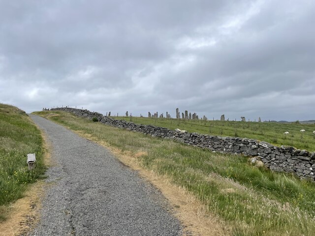
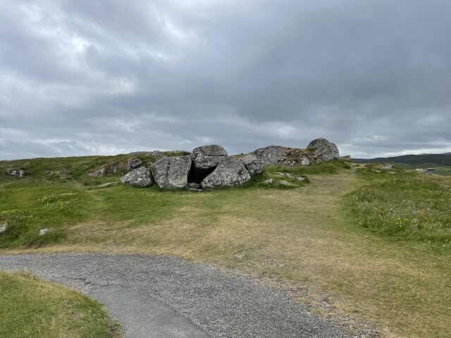
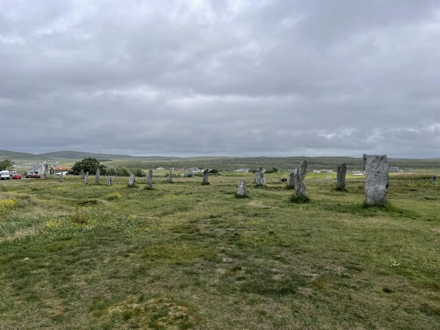
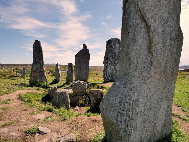
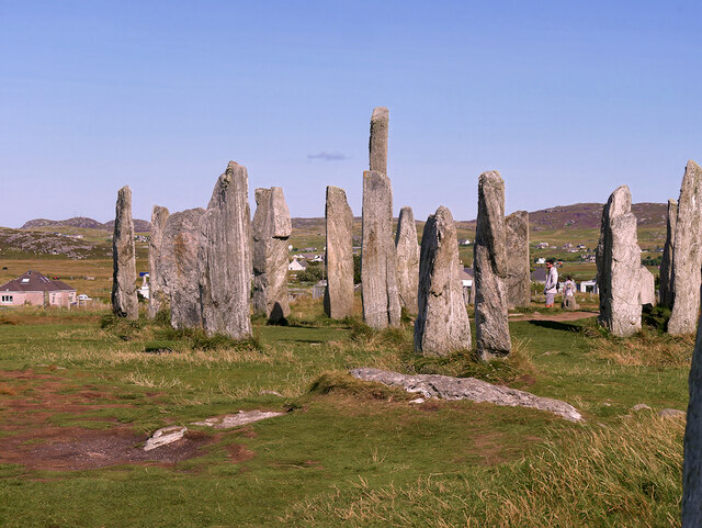
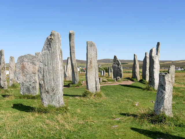
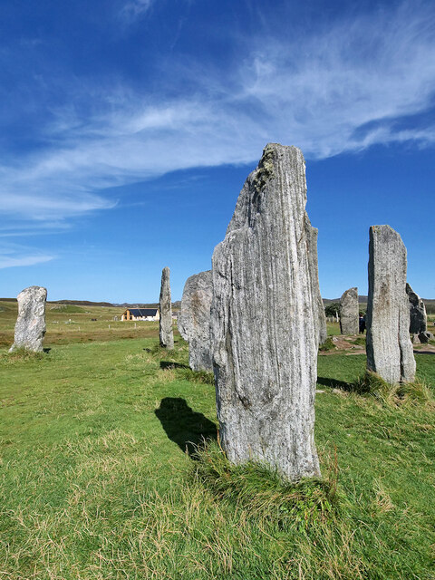
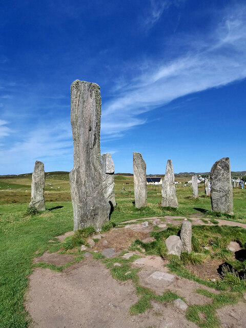
Callanish Stones

The Callanish Stones (or "Callanish I": Scottish Gaelic: Clachan Chalanais or Tursachan Chalanais) are an arrangement of standing stones placed in a cruciform...

Nearby Amenities

Located within 500m of 58.214041,-6.7475829
Power: pole
Lat/Long: 58.2158619/-6.7400632
Source: Bing
Lat/Long: 58.2165734/-6.7480925
Source: Bing
Lat/Long: 58.2165041/-6.7481776
Source: Bing
Lat/Long: 58.2164325/-6.7479695
Source: Bing
Lat/Long: 58.2165024/-6.7478838
Source: Bing
Lat/Long: 58.2162892/-6.748003
Source: Bing
Lat/Long: 58.2163639/-6.7479076
Source: Bing
Lat/Long: 58.2163288/-6.7478085
Source: Bing
Lat/Long: 58.2162541/-6.7479039
Source: Bing
Lat/Long: 58.2163456/-6.7474342
Source: Bing
Lat/Long: 58.2162258/-6.7475577
Source: Bing
Lat/Long: 58.2161877/-6.7474246
Source: Bing
Lat/Long: 58.2163076/-6.747301
Source: Bing
Lat/Long: 58.2157618/-6.7460167
Source: Bing
Lat/Long: 58.2157673/-6.7461913
Source: Bing
Lat/Long: 58.215874/-6.7460447
Source: Bing
Lat/Long: 58.2157933/-6.7458331
Source: Bing
Lat/Long: 58.2163843/-6.7442962
Source: Bing
Lat/Long: 58.2163569/-6.7443293
Source: Bing
Lat/Long: 58.2164113/-6.7444916
Source: Bing
Lat/Long: 58.2164493/-6.7444457
Source: Bing
Lat/Long: 58.2164205/-6.7443599
Source: Bing
Lat/Long: 58.2164427/-6.744333
Source: Bing
Lat/Long: 58.2164092/-6.744233
Source: Bing
Lat/Long: 58.2163764/-6.7442727
Source: Bing
Lat/Long: 58.2162012/-6.7440229
Source: Bing
Lat/Long: 58.2162361/-6.7441274
Source: Bing
Lat/Long: 58.2162982/-6.7440526
Source: Bing
Lat/Long: 58.2162632/-6.7439481
Source: Bing
Lat/Long: 58.2160385/-6.7442567
Source: Bing
Lat/Long: 58.2161572/-6.7441273
Source: Bing
Lat/Long: 58.2161199/-6.7440036
Source: Bing
Lat/Long: 58.2160011/-6.744133
Source: Bing
Lat/Long: 58.2158503/-6.7432645
Source: Bing
Lat/Long: 58.2158278/-6.7431882
Source: Bing
Lat/Long: 58.215702/-6.7432566
Source: Bing
Lat/Long: 58.2157392/-6.7433826
Turning Circle
Lat/Long: 58.2168752/-6.7495699
Telephone
Booth: KX100
Covered: booth
Lat/Long: 58.2174148/-6.750582
Passing Place
Lat/Long: 58.2179988/-6.7455812
Power: pole
Lat/Long: 58.2163051/-6.7408602
Power: pole
Lat/Long: 58.2167565/-6.7415859
Power: pole
Lat/Long: 58.2170264/-6.7420676
Power: pole
Lat/Long: 58.2175528/-6.742937
Power: pole
Lat/Long: 58.2180558/-6.7437842
Power: pole
Lat/Long: 58.2175356/-6.7444224
Power: pole
Lat/Long: 58.2170315/-6.7444763
Power: pole
Lat/Long: 58.2165248/-6.7444653
Power: pole
Lat/Long: 58.2156806/-6.7444566
Power: pole
Lat/Long: 58.2163054/-6.7438637
Power: pole
Lat/Long: 58.2168947/-6.7434349
Power: pole
Lat/Long: 58.2184731/-6.7489206
Power: pole
Lat/Long: 58.2179674/-6.7494007
Power: pole
Lat/Long: 58.2182485/-6.7504264
Power: pole
Lat/Long: 58.2181252/-6.7499532
Power: pole
Lat/Long: 58.2176099/-6.7488081
Power: pole
Lat/Long: 58.2174477/-6.7484327
Power: pole
Lat/Long: 58.2171225/-6.7486138
Power: pole
Lat/Long: 58.2168688/-6.7487383
Power: pole
Lat/Long: 58.2167156/-6.7483267
Power: pole
Lat/Long: 58.2179448/-6.7461038
Power: pole
Lat/Long: 58.2178106/-6.746994
Power: pole
Lat/Long: 58.2176817/-6.7479349
Power: pole
Lat/Long: 58.2175287/-6.7495161
Power: pole
Lat/Long: 58.2174452/-6.7504062
Power: pole
Lat/Long: 58.2172693/-6.7518134
Power: pole
Lat/Long: 58.2171906/-6.7524821
Power: pole
Lat/Long: 58.218149/-6.7453628
Barrier: cattle_grid
Lat/Long: 58.218051/-6.7455515
Barrier: cattle_grid
Lat/Long: 58.2180567/-6.7447133
Barrier: cattle_grid
Lat/Long: 58.2181021/-6.7440514
Barrier: cattle_grid
Lat/Long: 58.2159608/-6.7457264
Barrier: cattle_grid
Lat/Long: 58.214132/-6.7399027
Post Box
Post Box Type: lamp
Royal Cypher: scottish_crown
Lat/Long: 58.2174142/-6.7506848
Generator Method: photovoltaic
Generator Output Electricity: small_installation
Generator Source: solar
Generator Type: solar_photovoltaic_panel
Power: generator
Lat/Long: 58.2167088/-6.7466415
The data included in this document is from www.openstreetmap.org. The data is made available under ODbL.

Have you been to Sgeir an Eoin?

Leave your review of Sgeir an Eoin below (or comments, questions and feedback).