Cailleach a' Phuirt Bhàin Rock
Coastal Feature, Headland, Point in Argyllshire
Scotland
Cailleach a' Phuirt Bhàin Rock

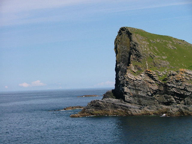
Cailleach a' Phuirt Bhàin Rock is a prominent coastal feature located in Argyllshire, Scotland. Situated on the west coast of the country, this rock formation is a well-known headland and point that attracts visitors with its stunning natural beauty and intriguing folklore.
The rock is named after the Cailleach, a mythical figure in Scottish folklore who is said to be the creator of the landscape. The name itself translates to "The Old Woman of Port Bàn," further adding to the mystique surrounding this coastal feature.
Rising dramatically from the surrounding sea, Cailleach a' Phuirt Bhàin Rock is a towering geological formation that commands attention. Its rugged cliffs and jagged edges offer a breathtaking sight, especially when the waves crash against its base during stormy weather.
Aside from its natural beauty, the rock is also home to a diverse range of wildlife. Seabirds, such as puffins, gannets, and guillemots, can often be seen nesting on the cliffs, adding to the picturesque allure of the area.
Due to its location, Cailleach a' Phuirt Bhàin Rock is also popular among outdoor enthusiasts. Hikers and nature lovers are drawn to the headland, as it offers stunning coastal views and opportunities for exploration.
Overall, Cailleach a' Phuirt Bhàin Rock is a captivating coastal feature in Argyllshire that combines natural beauty, folklore, and outdoor adventure. It is a must-visit location for anyone seeking to immerse themselves in Scotland's rich natural and cultural heritage.
If you have any feedback on the listing, please let us know in the comments section below.
Cailleach a' Phuirt Bhàin Rock Images
Images are sourced within 2km of 55.82423/-6.4573426 or Grid Reference NR2067. Thanks to Geograph Open Source API. All images are credited.


![Gravestones Overlooking Traigh Fleisgein Bheag The left hand one is inscribed "DEC AD 1818". It was a fairly common belief throughout Britain that drowned sailors should not be buried in the local churchyard otherwise the sea might come and take them back. So it was custom to bury them on the shore where they were found.
A letter from the Madras Courier of all newspapers perhaps provides a clue:—
DREADFUL SHIPWRECK.
A letter from Eliester (Islay) dated 10th November says, " A large vessel was last night lost of the back of the island here and all hands; she has gone to a thousand pieces. The boat came ashore, but no name upon it, but I found a board on which the Augustus, for Philadelphia was painted. This is all the information I can give about the unfortunate vessel; a good quantity of square timber is come ashore betwixt Port Newhaven and Claddach."
Britishnewspaperarchive.co.uk. (2022). DREADFUL SHIPWRECK. | Madras Courier | Tuesday 05 May 1818 | British Newspaper Archive. [online] Available at: <span class="nowrap"><a title="https://www.britishnewspaperarchive.co.uk/viewer/bl/0002925/18180505/031/0005" rel="nofollow ugc noopener" href="https://www.britishnewspaperarchive.co.uk/viewer/bl/0002925/18180505/031/0005">Link</a><img style="margin-left:2px;" alt="External link" title="External link - shift click to open in new window" src="https://s1.geograph.org.uk/img/external.png" width="10" height="10"/></span> [Accessed 15 May 2022].
See Canmore listing <span class="nowrap"><a title="https://canmore.org.uk/site/82725" rel="nofollow ugc noopener" href="https://canmore.org.uk/site/82725">Link</a><img style="margin-left:2px;" alt="External link" title="External link - shift click to open in new window" src="https://s1.geograph.org.uk/img/external.png" width="10" height="10"/></span>](https://s1.geograph.org.uk/photos/01/53/015337_af372825.jpg)


Cailleach a' Phuirt Bhàin Rock is located at Grid Ref: NR2067 (Lat: 55.82423, Lng: -6.4573426)
Unitary Authority: Argyll and Bute
Police Authority: Argyll and West Dunbartonshire
What 3 Words
///news.encodes.senior. Near Port Charlotte, Argyll & Bute
Related Wikis

HMS Graph
HMS Graph (pennant number P715) was a German Type VIIC U-boat that the British Royal Navy captured during World War II. Commissioned as U-570 in Nazi Germany...

Loch Gorm Castle
Loch Gorm Castle is a ruined castle located on Eilean Mòr (big island) on Loch Gorm, Islay, Scotland. It was once a stronghold of Clan Macdonald. The castle...

Kilchoman distillery
Kilchoman distillery (pronounced Kil-ho-man) is a distillery that produces single malt Scotch whisky on Islay, an island of the Inner Hebrides. Kilchoman...

Kilchoman
Kilchoman ( kil-(K)HOM-ən; Scottish Gaelic: Cill Chomain [kʲʰiːʎ ˈxɔmɛɲ]) is a small settlement and large parish on the Scottish island of Islay, within...
Related Videos

Evening and Sunset at Saligo Bay, Isle of Islay, Scotland
An evening at Saligo Bay on the west of the Isle of Islay in Scotland. After a beautiful sunny day we drive from Kilchoman to Saligo ...

Beautiful Saligo Bay waves, Isle of Islay
A beautiful September evening on the west of Islay in September 2021, just after sunset. Some beautiful waves are rolling into ...

Saligo Bay, Isle of Islay, from the air - Directors Cut
Following on from an earlier teaser here is the full video of a flight over beautiful Saligo Bay on the west of the Isle of Islay in ...

Oystercatchers in Saligo Bay, Isle of Islay, Scotland
A few Oystercatchers on rocks and the beach in Saligo Bay on the west coast of Islay in Scotland. That is all.
Nearby Amenities
Located within 500m of 55.82423,-6.4573426Have you been to Cailleach a' Phuirt Bhàin Rock?
Leave your review of Cailleach a' Phuirt Bhàin Rock below (or comments, questions and feedback).