An Coire

Coastal Feature, Headland, Point in Argyllshire

Scotland

An Coire

Memorial to Lieutenant David Lowe Macintyre David Lowe Macintyre VC, CB (18 June 1895 – 31 July 1967) was a Scottish recipient of the Victoria Cross.
Memorial to Lieutenant David Lowe Macintyre Credit: Andrew Abbott

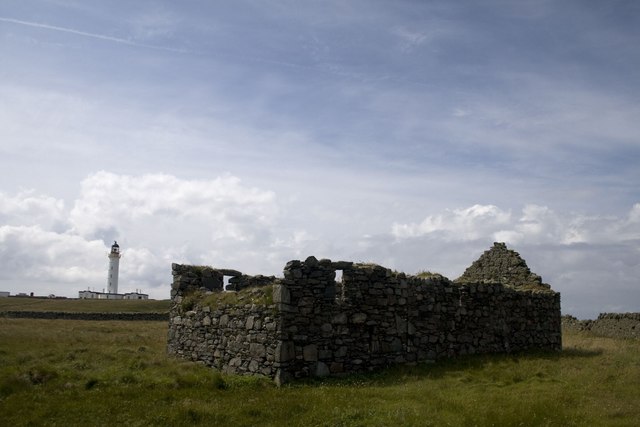
An Coire is a captivating headland located in Argyllshire, Scotland. Situated along the picturesque coastline, this prominent geographical feature offers breathtaking views of the surrounding area. With its rugged cliffs, stunning seascapes, and diverse wildlife, An Coire is a popular destination for nature enthusiasts and outdoor adventurers.

The headland is characterized by its towering cliffs that rise dramatically from the sea below. These cliffs, composed of ancient rock formations, showcase a variety of colors and textures, adding to the allure of the landscape. The constant crashing of waves against the base of the cliffs creates a mesmerizing symphony that resonates throughout the area.

An Coire also boasts a rich biodiversity, making it a haven for wildlife lovers. The headland is home to a wide range of bird species, including puffins, guillemots, and razorbills. These birds can be seen nesting in the crevices of the cliffs, adding a vibrant burst of color to the rugged terrain. Additionally, seals can often be spotted basking on the rocks, providing a delightful sight for visitors.

Visitors to An Coire can take advantage of the well-maintained walking trails that wind along the headland. These trails offer stunning panoramic views of the surrounding coastline, allowing visitors to fully immerse themselves in the natural beauty of the area. Photographers and artists are particularly drawn to the headland, as its unique topography and ever-changing light create endless opportunities for capturing the perfect shot.

In summary, An Coire is a captivating headland in Argyllshire, Scotland, offering a mesmerizing blend of rugged cliffs, stunning seascapes, and diverse wildlife. Its natural beauty and tranquility make it a must-visit destination for those seeking an enchanting coastal experience.

If you have any feedback on the listing, please let us know in the comments section below.

An Coire Images

Images are sourced within 2km of 55.66912/-6.515544 or Grid Reference NR1650. Thanks to Geograph Open Source API. All images are credited.

Memorial to Lieutenant David Lowe Macintyre David Lowe Macintyre VC, CB (18 June 1895 – 31 July 1967) was a Scottish recipient of the Victoria Cross.
Memorial to Lieutenant David Lowe Macintyre
David Lowe Macintyre VC, CB (18 June 1895 – 31 July 1967) was a Scottish recipient of the Victoria Cross.
Boat under repair
Boat under repair
Main Street, Port Wemyss/Bun Othan
Village Hall
Village Hall
Portnahaven
Portnahaven
Views out to sea Portnahaven
Portnahaven, Parish Church
OS Cut Mark - Portnahaven, Parish Church <span class="nowrap"><a title="https://www.bench-marks.org.uk/bm58120" rel="nofollow ugc noopener" href="https://www.bench-marks.org.uk/bm58120">Link</a><img style="margin-left:2px;" alt="External link" title="External link - shift click to open in new window" src="https://s1.geograph.org.uk/img/external.png" width="10" height="10"/></span>
OS Cut Mark - Portnahaven, Parish Church
View to Orsay from Port Wemyss
Former Portnahaven Coast Guard Lookout
Portnahaven
Portnahaven
Former school, Portnahaven Now a holiday let.
Former school, Portnahaven
Now a holiday let.
OS Cut Mark - Portnahaven, Old School <span class="nowrap"><a title="https://www.bench-marks.org.uk/bm58122" rel="nofollow ugc noopener" href="https://www.bench-marks.org.uk/bm58122">Link</a><img style="margin-left:2px;" alt="External link" title="External link - shift click to open in new window" src="https://s1.geograph.org.uk/img/external.png" width="10" height="10"/></span>
OS Cut Mark - Portnahaven, Old School
Orsay Chapel and Lighthouse, Islay Orsay is a tiny island situated off the Rhinns peninsula on Islay's west coast. It is uninhabited now, but once was home to the lighthouse keeper and his family and, before that, presumably to a religious community.
Orsay Chapel and Lighthouse, Islay
Orsay is a tiny island situated off the Rhinns peninsula on Islay's west coast. It is uninhabited now, but once was home to the lighthouse keeper and his family and, before that, presumably to a religious community.
Portnahaven Bay
Portnahaven Bay
Rhinns of Islay Lighthouse The light is located on Orsay, and seen here across the water from Port Wemyss on Islay.
Rhinns of Islay Lighthouse
The light is located on Orsay, and seen here across the water from Port Wemyss on Islay.
Portnahaven, or Port nah-Abhainne Sun drenched village at the south western tip of the Rinns peninsula.
Portnahaven, or Port nah-Abhainne
Sun drenched village at the south western tip of the Rinns peninsula.
Show me another place!

An Coire is located at Grid Ref: NR1650 (Lat: 55.66912, Lng: -6.515544)

Unitary Authority: Argyll and Bute

Police Authority: Argyll and West Dunbartonshire

What 3 Words

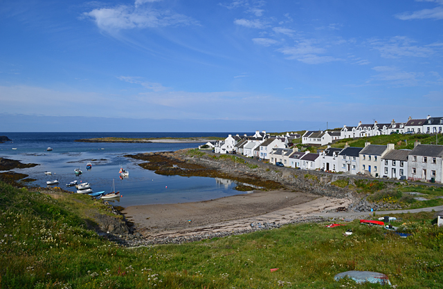
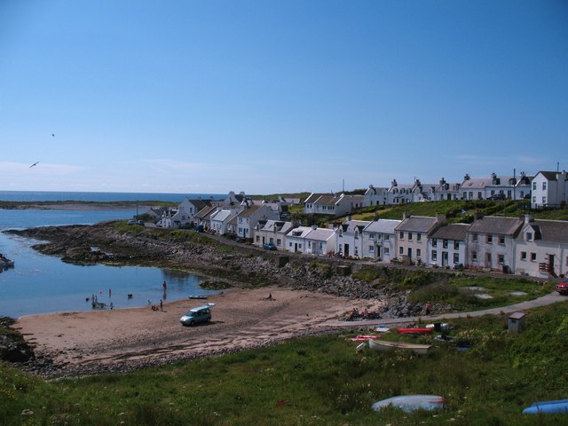
///disband.denoting.wool. Near Portnahaven, Argyll & Bute

Nearby Locations

An Coire

Related Wikis

Orsay, Inner Hebrides

Orsay (Scottish Gaelic: Orasaigh) is a small island in the Inner Hebrides of Scotland. It lies a short distance off the west coast of the island of Islay...

Eilean Mhic Coinnich

Eilean Mhic Coinnich, also known as Mackenzie Island (although recorded on the Land Register as McKenseys Island), is an uninhabited island of 17.3 hectares...

Portnahaven

Portnahaven (Scottish Gaelic: Port na h-Abhainne, meaning river port) is a village on Islay in the Inner Hebrides, Scotland. The village is within the...

Rhinns complex

The Rhinns complex is a deformed Palaeoproterozoic igneous complex that is considered to form the basement to the Colonsay Group of metasedimentary rocks...

Nearby Amenities

Located within 500m of 55.66912,-6.515544
Rinns of Islay Lighthouse
Man Made: lighthouse
Seamark Light 1 Character: Fl
Seamark Light 1 Colour: white
Seamark Light 1 Height: 46
Seamark Light 1 Period: 5
Seamark Light 1 Range: 24
Seamark Light 1 Sector End: 184
Seamark Light 1 Sector Start: 256
Seamark Light 1 Sequence: 0.2+(4.8)
Seamark Light Reference: A 4256
Seamark Name: Rhinns of Islay
Seamark Type: light_major
Wikidata: Q2148102
Lat/Long: 55.6731114/-6.5132529
Orsay Island
Note: Geodetic reference point for UK baseline
Ref: 25
Source: The Territorial Sea (Amendment) Order 1998 (No. 2564)
Lat/Long: 55.6732802/-6.5173617
The data included in this document is from www.openstreetmap.org. The data is made available under ODbL.

Have you been to An Coire?

Leave your review of An Coire below (or comments, questions and feedback).