Bogha na Muilne
Coastal Feature, Headland, Point in Ross-shire
Scotland
Bogha na Muilne

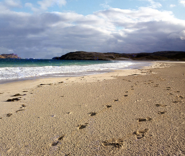
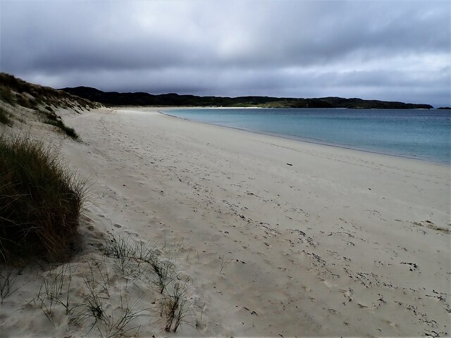
Bogha na Muilne is a prominent coastal feature located in Ross-shire, Scotland. It is a headland that extends out into the North Atlantic Ocean, forming a distinct point along the rugged coastline. The name "Bogha na Muilne" translates to "arch of the mill" in Gaelic, which is derived from its unique geological formation.
This headland is characterized by its dramatic cliffs and rock formations, which have been sculpted by the relentless force of the ocean waves over thousands of years. The cliffs rise to significant heights, offering breathtaking panoramic views of the surrounding landscape and the vast expanse of the sea. The rugged terrain and the crashing waves add to the dramatic atmosphere of the area.
Bogha na Muilne is also known for its diverse wildlife. The surrounding waters are home to a variety of marine species, including seals, dolphins, and seabirds, making it a popular spot for wildlife enthusiasts and birdwatchers. The headland provides an ideal habitat for these creatures, with its rocky outcrops providing nesting sites and shelter.
Visitors to Bogha na Muilne can explore the area by following the coastal paths that wind along the cliff tops. The paths offer breathtaking views and access to secluded beaches and coves, providing opportunities for coastal walks and picnics. It is important to note that the cliffs can be dangerous, and caution should be exercised when venturing close to the edge.
Overall, Bogha na Muilne is a stunning natural feature that showcases the raw beauty of Scotland's coastal landscape. Its unique geological formations, diverse wildlife, and breathtaking views make it a must-visit destination for nature lovers and those seeking a connection with the untamed forces of nature.
If you have any feedback on the listing, please let us know in the comments section below.
Bogha na Muilne Images
Images are sourced within 2km of 58.211108/-6.9043416 or Grid Reference NB1235. Thanks to Geograph Open Source API. All images are credited.


Bogha na Muilne is located at Grid Ref: NB1235 (Lat: 58.211108, Lng: -6.9043416)
Unitary Authority: Na h-Eileanan an Iar
Police Authority: Highlands and Islands
What 3 Words
///sugar.aside.carpentry. Near Carloway, Na h-Eileanan Siar
Related Wikis

Fuaigh Mòr
Fuaigh Mòr (sometimes anglicised as Vuia Mor) is an island in the Outer Hebrides of Scotland. It is off the west coast of Lewis near Great Bernera in...
Loch Ròg
Loch Ròg or Loch Roag is a large sea loch on the west coast of Lewis, Outer Hebrides. It is broadly divided into East Loch Roag and West Loch Roag with...

Loch na Berie
Loch Na Berie is a broch in the Outer Hebrides of Scotland, located approximately 400 yards from the shore, and is thought to have been located on an island...
Fuaigh Beag
Fuaigh Beag or Vuia Be(a)g is an island in the Outer Hebrides. It is off the west coast of Lewis near Great Bernera in Loch Roag. Its name means "little...

Vacsay
Vacsay (Scottish Gaelic: Bhacsaigh from Old Norse "bakkiey" meaning "peat bank island") is one of the Outer Hebrides. It is off the west coast of Lewis...
Flodaigh, Lewis
Flodaigh is a small island in Loch Roag on the west coast of Lewis in the Outer Hebrides of Scotland. It is about 33 hectares (82 acres) in extent and...

Kneep
Kneep (Scottish Gaelic: Cnìp) is a village on the Isle of Lewis, in the Outer Hebrides, Scotland. Kneep is within the parish of Uig.Various archaeological...
Pabaigh Mòr
Pabay Mòr or Pabaigh Mòr is an uninhabited island in the Outer Hebrides of Scotland. == History == The island's name comes from papey, an Old Norse name...
Have you been to Bogha na Muilne?
Leave your review of Bogha na Muilne below (or comments, questions and feedback).