Bealach nam Fiadh

Coastal Feature, Headland, Point in Ross-shire

Scotland

Bealach nam Fiadh

Erratic Boulder above Loch nan Uidhean An erratic boulder between Loch nan Uidhean and Loch na Creage 
Lionta in the Aird Mhor.
Erratic Boulder above Loch nan Uidhean Credit: Marc Calhoun

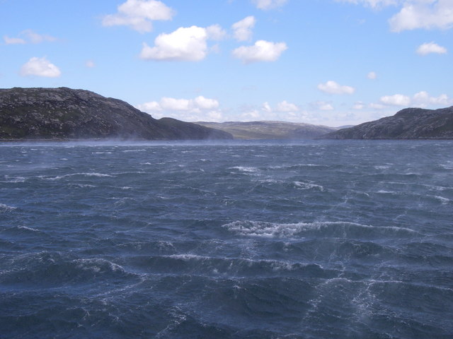
Bealach nam Fiadh is a prominent coastal feature located in Ross-shire, Scotland. It is a headland that juts out into the North Atlantic Ocean, forming a distinctive point along the rugged coastline. The name "Bealach nam Fiadh" translates to "Pass of the Deer" in Gaelic, reflecting the area's connection to wildlife.

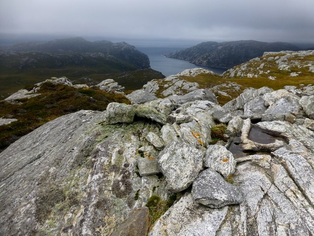
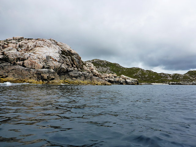
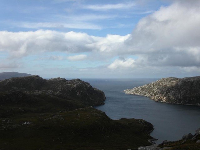
Rising to an elevation of approximately 200 meters, Bealach nam Fiadh offers stunning panoramic views of the surrounding landscape. Its craggy cliffs and rocky outcrops are a result of centuries of erosion by the relentless waves, creating a dramatic and picturesque scenery.

The headland is known for its rich biodiversity, with a variety of flora and fauna inhabiting the area. The cliffs provide nesting sites for numerous seabirds, such as gannets, guillemots, and puffins, making it a popular spot for birdwatchers. Grey seals can often be spotted lounging on the nearby rocky shores, while dolphins and porpoises occasionally frolic in the waters offshore.

Visitors to Bealach nam Fiadh can explore the headland by following a well-marked trail that winds along the cliff edge. The path offers breathtaking views of the sea and the surrounding coastal landscape, providing ample opportunities for photography and nature appreciation. The rugged terrain and exposed location make it a challenging but rewarding hike for outdoor enthusiasts.

Overall, Bealach nam Fiadh is a captivating coastal feature that showcases the raw beauty of Scotland's coastline. Its stunning views, abundant wildlife, and rugged charm make it a must-visit destination for nature lovers and adventure seekers alike.

If you have any feedback on the listing, please let us know in the comments section below.

Bealach nam Fiadh Images

Images are sourced within 2km of 58.048126/-7.0421704 or Grid Reference NB0217. Thanks to Geograph Open Source API. All images are credited.

Erratic Boulder above Loch nan Uidhean An erratic boulder between Loch nan Uidhean and Loch na Creage 
Lionta in the Aird Mhor.
Erratic Boulder above Loch nan Uidhean
An erratic boulder between Loch nan Uidhean and Loch na Creage Lionta in the Aird Mhor.
Mullach na h-Airde Bige Second HuMP around the northern edge of Loch Resort on an Alan Holmes RIB trip. What a brilliant day.
Name: Mullach na h-Airde Bige
Hill number: 4947
Height: 182m / 597ft
Area: 24A: Lewis and Nearby Islands
Class: Hu,1
Grid ref: NB026188 (est)
Drop: 128m
Col: 54m  NB044194
Mullach na h-Airde Bige
Second HuMP around the northern edge of Loch Resort on an Alan Holmes RIB trip. What a brilliant day. Name: Mullach na h-Airde Bige Hill number: 4947 Height: 182m / 597ft Area: 24A: Lewis and Nearby Islands Class: Hu,1 Grid ref: NB026188 (est) Drop: 128m Col: 54m NB044194
Steep Climb From Landing Point For Mullach na h-Airde Bige Our boatman Neil was a little worried by the steep climb up from our landing point. It proved to be no problem for Douglas Law, Alan Holmes, George Morl, Michael Earnshaw, Jim Bloomer, Martin Richardson, Mark Smith, Richard Tibbetts and Colin Crawford who were soon on top of the HuMP, Mullach na h-Airde Bige.
Steep Climb From Landing Point For Mullach na h-Airde Bige
Our boatman Neil was a little worried by the steep climb up from our landing point. It proved to be no problem for Douglas Law, Alan Holmes, George Morl, Michael Earnshaw, Jim Bloomer, Martin Richardson, Mark Smith, Richard Tibbetts and Colin Crawford who were soon on top of the HuMP, Mullach na h-Airde Bige.
Eoranish More Bagged on a RIB trip with 8 others to the HuMPs north of Loch Resort. Looking west towards Mullach na h-Airde Bige.
Name: Eoranish More
Hill number: 104363
Height: 158m / 518ft
Area: 24A: Lewis and Nearby Islands
Class: 1
Grid ref: NB032188 (est)
Drop: 79m
Col: 79m
Eoranish More
Bagged on a RIB trip with 8 others to the HuMPs north of Loch Resort. Looking west towards Mullach na h-Airde Bige. Name: Eoranish More Hill number: 104363 Height: 158m / 518ft Area: 24A: Lewis and Nearby Islands Class: 1 Grid ref: NB032188 (est) Drop: 79m Col: 79m
Crossing Damp Moorland Crossing damp moorland after descending from Eoranish More and heading towards Aineabhal.
Crossing Damp Moorland
Crossing damp moorland after descending from Eoranish More and heading towards Aineabhal.
Sneathabhal Mor Third HuMP around the north of Loch Resort via an Alan Holmes RIB trip. Just a brilliant trip.
Name: Sneathabhal Mor
Hill number: 4949
Height: 175m / 574ft
Area: 24A: Lewis and Nearby Islands
Class: Hu,1
Grid ref: NB043177 (est)
Drop: 114m
Col: 61m  NB054178
Sneathabhal Mor
Third HuMP around the north of Loch Resort via an Alan Holmes RIB trip. Just a brilliant trip. Name: Sneathabhal Mor Hill number: 4949 Height: 175m / 574ft Area: 24A: Lewis and Nearby Islands Class: Hu,1 Grid ref: NB043177 (est) Drop: 114m Col: 61m NB054178
Meall nan Sidhean [Meall nan Sithean] Last of four HuMPs around the north of Loch Resort on an Alan Holmes RIB trip. What a brilliant day. The summit is one of 3 tops in a line with the middle rocky top being lower than the tops on either side.
Name: Meall nan Sidhean [Meall nan Sithean]
Hill number: 4948
Height: 177m / 581ft
Area: 24A: Lewis and Nearby Islands
Class: Hu,1
Grid ref: NB024175 (est)
Drop: 122m
Col: 55m  NB039176
Meall nan Sidhean [Meall nan Sithean]
Last of four HuMPs around the north of Loch Resort on an Alan Holmes RIB trip. What a brilliant day. The summit is one of 3 tops in a line with the middle rocky top being lower than the tops on either side. Name: Meall nan Sidhean [Meall nan Sithean] Hill number: 4948 Height: 177m / 581ft Area: 24A: Lewis and Nearby Islands Class: Hu,1 Grid ref: NB024175 (est) Drop: 122m Col: 55m NB039176
View Across To Coirnis View across to Coirnis, 77 metres and a P30 hill. This is close to the spot that the RIB tender boat collected us after climbing Meall nan Sidhean.
View Across To Coirnis
View across to Coirnis, 77 metres and a P30 hill. This is close to the spot that the RIB tender boat collected us after climbing Meall nan Sidhean.
Loch Reasort from north shore Looking down Loch Reasort from the north shore after a 13 mile cycle/walk from Uig
Loch Reasort from north shore
Looking down Loch Reasort from the north shore after a 13 mile cycle/walk from Uig
Boulder on North Shore of Loch Reasort Reached this point after a 13 mile cycle/walk from Uig. While sitting here the bay was circled by a golden eagle.
Boulder on North Shore of Loch Reasort
Reached this point after a 13 mile cycle/walk from Uig. While sitting here the bay was circled by a golden eagle.
Rubha Geodha nan Sgarbh The entrance to Loch Tealasvay is well concealed close to the right of the picture.
Rubha Geodha nan Sgarbh
The entrance to Loch Tealasvay is well concealed close to the right of the picture.
A deep cleft
A deep cleft
Rubha Càrnach
Rubha Càrnach
Entering Loch Reasort into the teeth of a Gale. Mouth of Loch Reasort, view Eastwards.
Entering Loch Reasort into the teeth of a Gale.
Mouth of Loch Reasort, view Eastwards.
Mol Tealasbhaigh Even in this remote inlet on the Atlantic Western Seaboard of Harris there is much evidence of plastic litter
Mol Tealasbhaigh
Even in this remote inlet on the Atlantic Western Seaboard of Harris there is much evidence of plastic litter
Aird Bheag Number 1 Aird Bheag on the shore of Loch Hamnaway
Aird Bheag
Number 1 Aird Bheag on the shore of Loch Hamnaway
Loch Thamnabhaigh Entrance A sheltered sealoch and anchorage in south west Lewis.
Loch Thamnabhaigh Entrance
A sheltered sealoch and anchorage in south west Lewis.
Looking from Conagar towards Meall Mor
Show me another place!

Bealach nam Fiadh is located at Grid Ref: NB0217 (Lat: 58.048126, Lng: -7.0421704)

Unitary Authority: Na h-Eileanan an Iar

Police Authority: Highlands and Islands

What 3 Words

///happen.promising.husky. Near Tarbert, Na h-Eileanan Siar

Related Wikis

Scarp, Scotland

Scarp (Scottish Gaelic: An Sgarp) is an uninhabited island in the Outer Hebrides of Scotland, west of Hushinish on Harris. Once inhabited, the island was...

Eilean Mhealasta

Eilean Mhealasta (Mealista Island) is an uninhabited island off the west coast of Lewis in the Outer Hebrides of Scotland. It takes its name from Mealista...

Hushinish

Huisinish or Hushinish (Scottish Gaelic Hùisinis) is a remote place on the west coast of Harris in the Outer Hebrides of Scotland. It lies at the end of...

Tiorga Mor

Tiorga Mor (679 m) is a mountain in Harris, in the Outer Hebrides of Scotland. The most westerly peak of the high mountains of Harris, it is a very rugged...

Uladail

Uladail is a location near Amhuinnsuidhe, on Harris in the Outer Hebrides, Scotland. Sron Ulladail is a sheer cliff which at 370 metres (1,210 ft) is one...

Game pieces of the Lewis chessmen hoard

Game pieces of the Lewis chessmen hoard include the ninety-three game pieces of the Lewis chessmen hoard found on the Isle of Lewis in the Outer Hebrides...

Mealista

Mealista (Scottish Gaelic: Mealasta) was a township in the west of the Isle of Lewis. It is currently largely uninhabited due to the Highland Clearances...

Brenish

Brenish (Scottish Gaelic: Brèinis) is a small village situated on the west coast of the Isle of Lewis, which is part of the Outer Hebrides of Scotland...

Nearby Amenities

Located within 500m of 58.048126,-7.0421704
Created By: dmgroom_coastlines
Lat/Long: 58.05124/-7.04616
The data included in this document is from www.openstreetmap.org. The data is made available under ODbL.

Have you been to Bealach nam Fiadh?

Leave your review of Bealach nam Fiadh below (or comments, questions and feedback).