South Chapel

Coastal Feature, Headland, Point in Cornwall

England

South Chapel

Trig pillar
Trig pillar Credit: Alex McGregor

South Chapel is a stunning coastal feature located in Cornwall, England. Situated on the southernmost tip of the county, it is a prominent headland that extends into the Atlantic Ocean. This picturesque point offers breathtaking views of the surrounding landscape, making it a popular destination for tourists and locals alike.

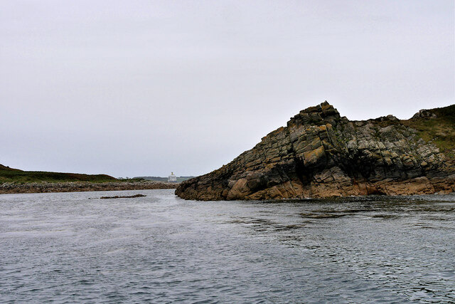
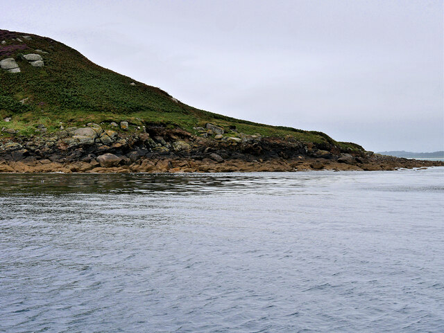
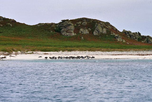
The South Chapel headland is characterized by dramatic cliffs that rise majestically from the sea. These cliffs are composed of rugged granite, which has been shaped and carved by the powerful forces of wind and waves over countless years. The result is a striking and varied coastline, with sheer cliffs, hidden coves, and rocky outcrops.

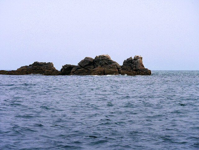
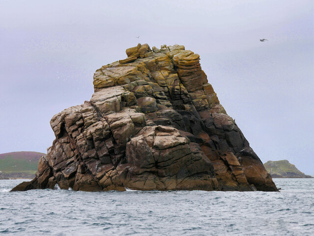
The headland is also known for its unique geological formations, including several sea stacks that have been formed by the relentless erosion of the cliffs. These towering rock formations jut out of the ocean, creating a dramatic and otherworldly sight.

In addition to its natural beauty, South Chapel is also steeped in history. The headland is home to the ruins of a medieval chapel, which is believed to have been built in the 13th century. The chapel's remains serve as a reminder of Cornwall's rich heritage and offer visitors a glimpse into the region's past.

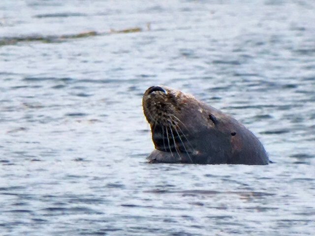
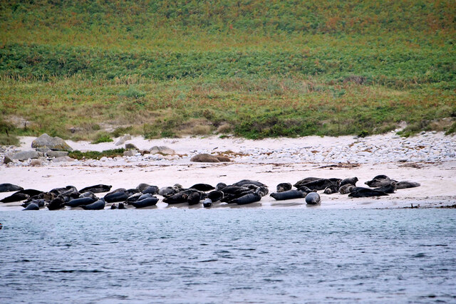
South Chapel is a haven for wildlife, with its cliffs providing nesting sites for numerous bird species, including fulmars and kittiwakes. It is also a popular spot for birdwatching, as migrating seabirds can often be spotted passing through during certain times of the year.

Overall, South Chapel is a captivating coastal feature that showcases the beauty and diversity of Cornwall's rugged coastline. With its breathtaking views, historical significance, and abundant wildlife, it is a must-visit destination for nature enthusiasts and history buffs alike.

If you have any feedback on the listing, please let us know in the comments section below.

South Chapel Images

Images are sourced within 2km of 49.966308/-6.260552 or Grid Reference SV9416. Thanks to Geograph Open Source API. All images are credited.

Trig pillar
Trig pillar
A track on eastern St Martin’s The track runs uphill from the eastern end of Higher Town Bay to the Chapel Down and the Daymark.
A track on eastern St Martin’s
The track runs uphill from the eastern end of Higher Town Bay to the Chapel Down and the Daymark.
The Daymark From within the ruins of the Admiralty signal station of  1805.

The signal station is included in the Scheduled Monument comprising the whole of Chapel down and is described thus:

In 1804, an Admiralty signal station was built on northern Chapel Down to communicate with naval vessels by signal mast and to report on enemy shipping movements. It was decommissioned in 1815, superseded by semaphore operated from St Mary's. Its main building stands to 2.3m high in the north of a subrectangular enclosure 38m long, NNW-SSE, by up to 21m wide.

List Entry Number:1016508  <span class="nowrap"><a title="https://historicengland.org.uk/listing/the-list/list-entry/1016508?section=official-list-entry" rel="nofollow ugc noopener" href="https://historicengland.org.uk/listing/the-list/list-entry/1016508?section=official-list-entry">Link</a><img style="margin-left:2px;" alt="External link" title="External link - shift click to open in new window" src="https://s1.geograph.org.uk/img/external.png" width="10" height="10"/></span>

The Daymark is separately listed Grade II*

List Entry Number:1141204 <span class="nowrap"><a title="https://historicengland.org.uk/listing/the-list/list-entry/1141204?section=official-list-entry" rel="nofollow ugc noopener" href="https://historicengland.org.uk/listing/the-list/list-entry/1141204?section=official-list-entry">Link</a><img style="margin-left:2px;" alt="External link" title="External link - shift click to open in new window" src="https://s1.geograph.org.uk/img/external.png" width="10" height="10"/></span>
The Daymark
From within the ruins of the Admiralty signal station of 1805. The signal station is included in the Scheduled Monument comprising the whole of Chapel down and is described thus: In 1804, an Admiralty signal station was built on northern Chapel Down to communicate with naval vessels by signal mast and to report on enemy shipping movements. It was decommissioned in 1815, superseded by semaphore operated from St Mary's. Its main building stands to 2.3m high in the north of a subrectangular enclosure 38m long, NNW-SSE, by up to 21m wide. List Entry Number:1016508 LinkExternal link The Daymark is separately listed Grade II* List Entry Number:1141204 LinkExternal link
Great Bay panorama On of the most beautiful spots on the islands.
Great Bay panorama
On of the most beautiful spots on the islands.
Great Ganilly, West Porth Great Ganilly (Cornish: Goonhyli Meur) is the largest of the Eastern Isles and consists of two hills joined together by a low sandy neck.
Great Ganilly, West Porth
Great Ganilly (Cornish: Goonhyli Meur) is the largest of the Eastern Isles and consists of two hills joined together by a low sandy neck.
Isles of Scilly, Nornour Nornour (Cornish: Ar No) consists of one hill covered in bracken. It lies to the north of Great Ganilly to which it is joined by a boulder causeway at low tide. There is a small area of heath on the hill with heather and bell heather.
Isles of Scilly, Nornour
Nornour (Cornish: Ar No) consists of one hill covered in bracken. It lies to the north of Great Ganilly to which it is joined by a boulder causeway at low tide. There is a small area of heath on the hill with heather and bell heather.
Rocky Ledge between Nornour and Great Ganilly Nornour (Cornish: Ar No) consists of one hill covered in bracken. It is connected to Great Ganilly by a boulder causeway during low tide. The pyramidal island in the background is Hanjague, which is approximately 1 kilometre away.
Rocky Ledge between Nornour and Great Ganilly
Nornour (Cornish: Ar No) consists of one hill covered in bracken. It is connected to Great Ganilly by a boulder causeway during low tide. The pyramidal island in the background is Hanjague, which is approximately 1 kilometre away.
The Eastern Isles, Nornour Nornour (Cornish: Ar No) consists of one hill covered in bracken. It lies to the north of Great Ganilly and is connected to it by a boulder causeway that is visible only during low tide. There is a small area of heath on the hill with heather and bell heather.
The Eastern Isles, Nornour
Nornour (Cornish: Ar No) consists of one hill covered in bracken. It lies to the north of Great Ganilly and is connected to it by a boulder causeway that is visible only during low tide. There is a small area of heath on the hill with heather and bell heather.
Isles of Scilly, Nornour Nornour (Cornish: Ar No) consists of one hill covered in bracken. It lies to the north of Great Ganilly to which it is joined by a boulder causeway at low tide.
Isles of Scilly, Nornour
Nornour (Cornish: Ar No) consists of one hill covered in bracken. It lies to the north of Great Ganilly to which it is joined by a boulder causeway at low tide.
Rocks on the North Coast of Nornour The Eastern Isles (Cornish: Enesow Goonhyli) are a group of twelve small uninhabited islands  located to the south–east of St Martin's. The islands lie within the Isles of Scilly Area of Outstanding Natural Beauty, part of the Scilly Heritage Coast and a Site of Special Scientific Interest (SSSI) first designated in 1971 for its flora and fauna (<span class="nowrap"><a title="https://en.wikipedia.org/wiki/Eastern_Isles" rel="nofollow ugc noopener" href="https://en.wikipedia.org/wiki/Eastern_Isles">Link</a><img style="margin-left:2px;" alt="External link" title="External link - shift click to open in new window" src="https://s1.geograph.org.uk/img/external.png" width="10" height="10"/></span> Wikipedia).
Rocks on the North Coast of Nornour
The Eastern Isles (Cornish: Enesow Goonhyli) are a group of twelve small uninhabited islands located to the south–east of St Martin's. The islands lie within the Isles of Scilly Area of Outstanding Natural Beauty, part of the Scilly Heritage Coast and a Site of Special Scientific Interest (SSSI) first designated in 1971 for its flora and fauna (LinkExternal link Wikipedia).
Isles of Scilly, Nornour The Eastern Isles (Cornish: Enesow Goonhyli) are a group of twelve small uninhabited islands  located to the south–east of St Martin's. The islands lie within the Isles of Scilly Area of Outstanding Natural Beauty, part of the Scilly Heritage Coast and a Site of Special Scientific Interest (SSSI) first designated in 1971 for its flora and fauna (<span class="nowrap"><a title="https://en.wikipedia.org/wiki/Eastern_Isles" rel="nofollow ugc noopener" href="https://en.wikipedia.org/wiki/Eastern_Isles">Link</a><img style="margin-left:2px;" alt="External link" title="External link - shift click to open in new window" src="https://s1.geograph.org.uk/img/external.png" width="10" height="10"/></span> Wikipedia).
Isles of Scilly, Nornour
The Eastern Isles (Cornish: Enesow Goonhyli) are a group of twelve small uninhabited islands located to the south–east of St Martin's. The islands lie within the Isles of Scilly Area of Outstanding Natural Beauty, part of the Scilly Heritage Coast and a Site of Special Scientific Interest (SSSI) first designated in 1971 for its flora and fauna (LinkExternal link Wikipedia).
Isles of Scilly Eastern Isles Looking through the gap between Nornour (on the right) and Great Ganilly.
Isles of Scilly Eastern Isles
Looking through the gap between Nornour (on the right) and Great Ganilly.
Seal Swimming in the Sea off Great Ganilly The Eastern Scilly Isles are one of three main grey seal (Halichoerus grypus) pupping areas.
Seal Swimming in the Sea off Great Ganilly
The Eastern Scilly Isles are one of three main grey seal (Halichoerus grypus) pupping areas.
Great Ganilly, Eastern Scilly Isles Great Ganilly (Cornish: Goonhyli Meur) is the largest of the Eastern Isles and consists of two hills joined together by a low sandy neck.
Great Ganilly, Eastern Scilly Isles
Great Ganilly (Cornish: Goonhyli Meur) is the largest of the Eastern Isles and consists of two hills joined together by a low sandy neck.
Grey Seals on the Beach at East Porth (Great Ganilly) The Eastern Scilly Isles are one of three main grey seal (Halichoerus grypus) pupping areas.
Grey Seals on the Beach at East Porth (Great Ganilly)
The Eastern Scilly Isles are one of three main grey seal (Halichoerus grypus) pupping areas.
Great Ganilly, East Porth The Eastern Scilly Isles are one of three main grey seal (Halichoerus grypus) pupping areas.
Great Ganilly, East Porth
The Eastern Scilly Isles are one of three main grey seal (Halichoerus grypus) pupping areas.
Isles of Scilly, Mouls The Eastern Isles (Cornish: Enesow Goonhyli) are a group of twelve small uninhabited islands  located to the south–east of St Martin's. The islands lie within the Isles of Scilly Area of Outstanding Natural Beauty, part of the Scilly Heritage Coast and a Site of Special Scientific Interest (SSSI) first designated in 1971 for its flora and fauna (<span class="nowrap"><a title="https://en.wikipedia.org/wiki/Eastern_Isles" rel="nofollow ugc noopener" href="https://en.wikipedia.org/wiki/Eastern_Isles">Link</a><img style="margin-left:2px;" alt="External link" title="External link - shift click to open in new window" src="https://s1.geograph.org.uk/img/external.png" width="10" height="10"/></span> Wikipedia).
Isles of Scilly, Mouls
The Eastern Isles (Cornish: Enesow Goonhyli) are a group of twelve small uninhabited islands located to the south–east of St Martin's. The islands lie within the Isles of Scilly Area of Outstanding Natural Beauty, part of the Scilly Heritage Coast and a Site of Special Scientific Interest (SSSI) first designated in 1971 for its flora and fauna (LinkExternal link Wikipedia).
The Eastern Isles, Hanjague Hanjague (Cornish: An Wynjek, the windy one) is a sea stack approximately one kilometre north-east of Great Gannilly, and is the easternmost island in the archipelago. The island has no vegetation and is used as a roost by birds.
The Eastern Isles, Hanjague
Hanjague (Cornish: An Wynjek, the windy one) is a sea stack approximately one kilometre north-east of Great Gannilly, and is the easternmost island in the archipelago. The island has no vegetation and is used as a roost by birds.
Show me another place!

South Chapel is located at Grid Ref: SV9416 (Lat: 49.966308, Lng: -6.260552)

Division: Isles of Scilly

Unitary Authority: Isles of Scilly

Police Authority: Devon and Cornwall

What 3 Words

///investor.justifies.kneeled. Near St Martin's, Isles of Scilly

Related Wikis

PS Earl of Arran (1860)

PS Earl of Arran was a passenger vessel operated by the Ardrossan Steamboat Company from 1860 to 1871 and the West Cornwall Steam Ship Company from 1871...

Great Ganilly

Great Ganilly ( gə-NIL-ee; Cornish: Goonhyli Veur, lit. 'great saltwater downs') is one of the Eastern Isles of the Isles of Scilly. It has a maximum total...

Eastern Isles

The Eastern Isles (Cornish: Enesow Goonhyli, islands of the salt water downs) are a group of twelve small uninhabited islands within the Isles of Scilly...

Higher Town, Isles of Scilly

Higher Town (Cornish: Trewartha) is the easternmost and largest settlement on the island of St Martin's in the Isles of Scilly, England. It is situated...

Related Videos

St Martins - Isles of Scilly BEAUTIFUL

St Martins - Isles of Scilly BEAUTIFUL Filmed and Edited by Paul Dinning - Wildlife in Cornwall Original Music Written and ...

St Martins - Scilly Isles - A 4K video tour

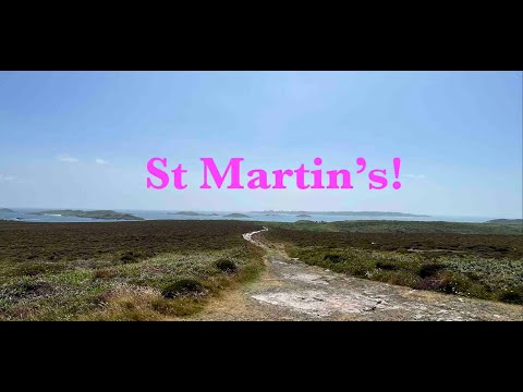
St Martin's is the most northeasterly and third largest of the main Scilly Isles. In this short video I take a walk more or less from end ...

Whelmed: The One with St Martin's

My day trip to St Martin's on the Isles of Scilly in England.

Par Beach, St Martin's

Par Beach, also known as Higher Town Bay and Higher Town Beach, is a beautiful beach on the island of St Martin's, Isles of ...

Nearby Amenities

Located within 500m of 49.966308,-6.260552
Chapel Down
Place: locality
Lat/Long: 49.9645213/-6.2651179
St Martin's Head
Place: locality
Lat/Long: 49.9674429/-6.2657758
Mullet Pool
Natural: bay
Lat/Long: 49.9635851/-6.2610873
Northward Bight
Natural: bay
Lat/Long: 49.9655865/-6.2622675
Southward Bight
Natural: bay
Lat/Long: 49.9649309/-6.2616345
Pope's Hole
Natural: cave_entrance
Lat/Long: 49.964402/-6.2624195
St Martins Head
Description: OS trig pillar
Ele: 47.137
Man Made: survey_point
Note: Accurate location import for imagery offset calibration
Ref: 10
Source: Ordnance Survey (OGL)
Survey Point: pillar
Lat/Long: 49.9664239/-6.2660514
The data included in this document is from www.openstreetmap.org. The data is made available under ODbL.

Have you been to South Chapel?

Leave your review of South Chapel below (or comments, questions and feedback).