Cordail Beag

Coastal Feature, Headland, Point in Inverness-shire

Scotland

Cordail Beag

A small inlet at Cidhe Eòlaigearraidh
A small inlet at Cidhe Eòlaigearraidh Credit: John Lucas

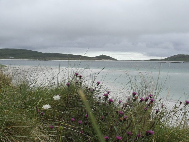
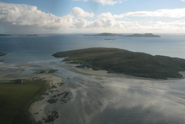
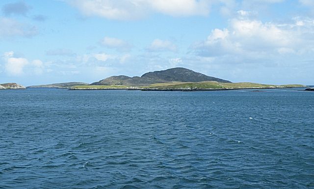
Cordail Beag is a small headland located in Inverness-shire, Scotland. It is situated along the rugged and picturesque coastline of the Highlands, offering stunning views of the surrounding landscape and the North Sea.

The headland is characterized by its rocky cliffs, which provide a habitat for a variety of seabirds such as gannets, puffins, and guillemots. The area is also known for its rich marine life, with seals often seen basking on the rocks below.

Visitors to Cordail Beag can enjoy scenic walks along the coastal path that winds its way around the headland, offering panoramic views of the sea and nearby islands. The area is popular with nature enthusiasts, photographers, and hikers looking to explore the natural beauty of the Scottish coastline.

In addition to its natural beauty, Cordail Beag is also steeped in history, with ancient ruins and archaeological sites scattered throughout the area. The headland offers a glimpse into Scotland's past and provides a unique opportunity to explore its cultural heritage while enjoying the stunning coastal scenery.

If you have any feedback on the listing, please let us know in the comments section below.

Cordail Beag Images

Images are sourced within 2km of 57.043097/-7.3910226 or Grid Reference NF7307. Thanks to Geograph Open Source API. All images are credited.

A small inlet at Cidhe Eòlaigearraidh
Jetty at Cidhe Eòlaigearraidh With the Island of Fuday in view.
Jetty at Cidhe Eòlaigearraidh
With the Island of Fuday in view.
Sgeir Meall na Hoe East Cardinal Buoy This yellow/black/yellow buoy emits three very quick white flashes every five seconds at night.
Sgeir Meall na Hoe East Cardinal Buoy
This yellow/black/yellow buoy emits three very quick white flashes every five seconds at night.
Grianamul west cardinal buoy This yellow/black/yellow buoy emits nine quick white flashes every fifteen seconds at night.
Grianamul west cardinal buoy
This yellow/black/yellow buoy emits nine quick white flashes every fifteen seconds at night.
Sgeir Meall Na Hoe Buoy viewed on the crossing from Eriskay to Barra
Greanamul Buoy and skerries complete with wildlife
Beach at Eolaigearraidh (Eoligarry)
"No Parking" sign at Cidhe Eolaigearraidh (Eoligarry Jetty) Prior to the start of the car ferry to Eriskay and the Uists a passenger only ferry ran from this jetty to South Uist.

Note the helpful sign to "Fish 'n' Ships"!
"No Parking" sign at Cidhe Eolaigearraidh (Eoligarry Jetty)
Prior to the start of the car ferry to Eriskay and the Uists a passenger only ferry ran from this jetty to South Uist. Note the helpful sign to "Fish 'n' Ships"!
Jetty at Eòlaigearraidh
Eoligarry Pier
Eoligarry Pier
Shore with rock outcrop Low, glaciated rock outcrops are lying level with the sand to the north of the harbour at Eòlaigearraidh.
Shore with rock outcrop
Low, glaciated rock outcrops are lying level with the sand to the north of the harbour at Eòlaigearraidh.
Folded rocks A low, glaciated rock platform extends for some distance. Although it is flat-lying it is not smooth because weathering and sand erosion have picked out the rock texture in an exquisite fashion, and this is enhanced by low, morning sunlight.
Folded rocks
A low, glaciated rock platform extends for some distance. Although it is flat-lying it is not smooth because weathering and sand erosion have picked out the rock texture in an exquisite fashion, and this is enhanced by low, morning sunlight.
Cow tracks The resident cows have created deep tracks in the soft, sandy soil of the machair.
Cow tracks
The resident cows have created deep tracks in the soft, sandy soil of the machair.
Bay by Cidhe Eòlaigearraidh A shallow bay to the north of the pier on a peaceful evening.
Bay by Cidhe Eòlaigearraidh
A shallow bay to the north of the pier on a peaceful evening.
Tràigh Cille-bharra Looking across the shore towards Orasaigh.
Tràigh Cille-bharra
Looking across the shore towards Orasaigh.
Shore at Eòlaigearraidh Lobster pots lying on the back of the jetty at Eòlaigearraidh, with a view across the bay to the southern crofts.
Shore at Eòlaigearraidh
Lobster pots lying on the back of the jetty at Eòlaigearraidh, with a view across the bay to the southern crofts.
Rock outcrop above the shore Eòlaigearraidh jetty is built out from a patch of elevated, rocky shore which is wonderfully covered with lichens. A couple of fine glacial erratic boulders lie on the outcrop.
Rock outcrop above the shore
Eòlaigearraidh jetty is built out from a patch of elevated, rocky shore which is wonderfully covered with lichens. A couple of fine glacial erratic boulders lie on the outcrop.
Artificial Oyster Beds Bags of oysters on raised racks.
Artificial Oyster Beds
Bags of oysters on raised racks.
Show me another place!

Cordail Beag is located at Grid Ref: NF7307 (Lat: 57.043097, Lng: -7.3910226)

Unitary Authority: Na h-Eileanan an Iar

Police Authority: Highlands and Islands

What 3 Words

///shaves.decent.stoppage. Near CastleBay, Na h-Eileanan Siar

Related Wikis

Fuday

Fuday (Scottish Gaelic: Fùideigh) is an uninhabited island of about 232 hectares (570 acres) and is one of ten islands in the Sound of Barra, a Site of...

Orosay

Orosay (Scottish Gaelic: Orasaigh) is a small uninhabited tidal island in the Sound of Barra lying at the north end of Traigh Mhòr, the "big beach" on...

Sound of Barra

The Sound of Barra is a large ocean inlet or sound situated to the north of the isle of Barra and to the south of South Uist in the Outer Hebrides in Scotland...

Traigh Mhòr

The Tràigh Mhòr, in English 'Big Beach', is a large expanse of sand forming a magnificent white beach at the northern end of the island of Barra in the...

Nearby Amenities

Located within 500m of 57.043097,-7.3910226
Ele: 68
Natural: peak
Lat/Long: 57.0464464/-7.3957069
Rubha nan Eun
Natural: cape
Lat/Long: 57.0428249/-7.3864846
The data included in this document is from www.openstreetmap.org. The data is made available under ODbL.

Have you been to Cordail Beag?

Leave your review of Cordail Beag below (or comments, questions and feedback).