Traillisgeir

Coastal Feature, Headland, Point in Inverness-shire

Scotland

Traillisgeir

A small inlet at Cidhe Eòlaigearraidh
A small inlet at Cidhe Eòlaigearraidh Credit: John Lucas

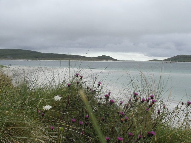
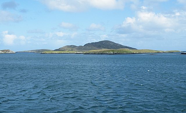
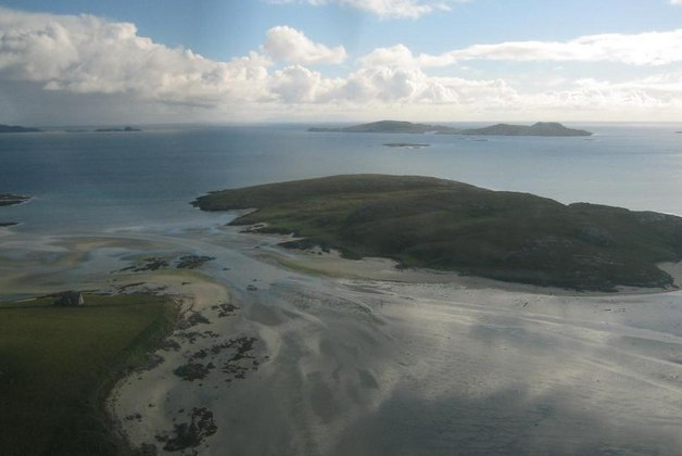
Traillisgeir is a prominent coastal feature located in Inverness-shire, Scotland. Situated on the rugged west coast, it is known for its stunning headland and distinctive point that juts out into the North Atlantic Ocean.

The headland of Traillisgeir is characterized by its steep cliffs and jagged rock formations, making it a visually striking landmark. These cliffs, which reach heights of up to 100 meters, provide an ideal vantage point for visitors to enjoy panoramic views of the surrounding coastline and the vast expanse of the ocean. The area is also home to a diverse range of seabirds, including gannets, puffins, and guillemots, making it a popular spot for birdwatching enthusiasts.

The point of Traillisgeir is a unique geological feature that extends into the sea, forming a natural boundary between two adjacent bays. This point is composed of rugged rocks, shaped over centuries by the relentless force of the waves. It serves as a natural barrier, protecting the coastline from erosion caused by the powerful tides and currents of the North Atlantic.

The location of Traillisgeir offers visitors the opportunity to engage in a variety of outdoor activities, such as hiking, photography, and wildlife spotting. The surrounding area is also rich in cultural and historical significance, with ancient ruins and archaeological sites nearby. The rugged beauty and remote tranquility of Traillisgeir make it a must-visit destination for nature lovers and those seeking a unique and immersive coastal experience.

If you have any feedback on the listing, please let us know in the comments section below.

Traillisgeir Images

Images are sourced within 2km of 57.054447/-7.4022343 or Grid Reference NF7208. Thanks to Geograph Open Source API. All images are credited.

A small inlet at Cidhe Eòlaigearraidh
Jetty at Cidhe Eòlaigearraidh With the Island of Fuday in view.
Jetty at Cidhe Eòlaigearraidh
With the Island of Fuday in view.
"No Parking" sign at Cidhe Eolaigearraidh (Eoligarry Jetty) Prior to the start of the car ferry to Eriskay and the Uists a passenger only ferry ran from this jetty to South Uist.

Note the helpful sign to "Fish 'n' Ships"!
"No Parking" sign at Cidhe Eolaigearraidh (Eoligarry Jetty)
Prior to the start of the car ferry to Eriskay and the Uists a passenger only ferry ran from this jetty to South Uist. Note the helpful sign to "Fish 'n' Ships"!
Jetty at Eòlaigearraidh
Eoligarry Pier
Eoligarry Pier
Shore with rock outcrop Low, glaciated rock outcrops are lying level with the sand to the north of the harbour at Eòlaigearraidh.
Shore with rock outcrop
Low, glaciated rock outcrops are lying level with the sand to the north of the harbour at Eòlaigearraidh.
Folded rocks A low, glaciated rock platform extends for some distance. Although it is flat-lying it is not smooth because weathering and sand erosion have picked out the rock texture in an exquisite fashion, and this is enhanced by low, morning sunlight.
Folded rocks
A low, glaciated rock platform extends for some distance. Although it is flat-lying it is not smooth because weathering and sand erosion have picked out the rock texture in an exquisite fashion, and this is enhanced by low, morning sunlight.
Cow tracks The resident cows have created deep tracks in the soft, sandy soil of the machair.
Cow tracks
The resident cows have created deep tracks in the soft, sandy soil of the machair.
Bay by Cidhe Eòlaigearraidh A shallow bay to the north of the pier on a peaceful evening.
Bay by Cidhe Eòlaigearraidh
A shallow bay to the north of the pier on a peaceful evening.
Dunes by Tràigh Sgùrabhal Sand dunes are a feature of the southern edge of Tràigh Sgùrabhal and extend all the way to Cidhe Eòlaigearraidh.
Dunes by Tràigh Sgùrabhal
Sand dunes are a feature of the southern edge of Tràigh Sgùrabhal and extend all the way to Cidhe Eòlaigearraidh.
Shallow waves Waves breaking gently on the eastern edge of Tràigh Sgùrabhal.
Shallow waves
Waves breaking gently on the eastern edge of Tràigh Sgùrabhal.
Shore of Tràigh Sgùrabhal The sandy shore below the edge of low dunes, sprinkled with cockleshells and dried kelp rods.
Shore of Tràigh Sgùrabhal
The sandy shore below the edge of low dunes, sprinkled with cockleshells and dried kelp rods.
Paddling on Tràigh Sgùrabhal Crystal-clear, shallow water in this beautiful bay.
Paddling on Tràigh Sgùrabhal
Crystal-clear, shallow water in this beautiful bay.
Crofts at Eòlaigearraidh The crofting landscape of the machair.
Crofts at Eòlaigearraidh
The crofting landscape of the machair.
Shore at Eòlaigearraidh Lobster pots lying on the back of the jetty at Eòlaigearraidh, with a view across the bay to the southern crofts.
Shore at Eòlaigearraidh
Lobster pots lying on the back of the jetty at Eòlaigearraidh, with a view across the bay to the southern crofts.
Rock outcrop above the shore Eòlaigearraidh jetty is built out from a patch of elevated, rocky shore which is wonderfully covered with lichens. A couple of fine glacial erratic boulders lie on the outcrop.
Rock outcrop above the shore
Eòlaigearraidh jetty is built out from a patch of elevated, rocky shore which is wonderfully covered with lichens. A couple of fine glacial erratic boulders lie on the outcrop.
Tràigh Sgurabhal Crystal clear and surprisingly warm.
Tràigh Sgurabhal
Crystal clear and surprisingly warm.
Artificial Oyster Beds Bags of oysters on raised racks.
Artificial Oyster Beds
Bags of oysters on raised racks.
Show me another place!

Traillisgeir is located at Grid Ref: NF7208 (Lat: 57.054447, Lng: -7.4022343)

Unitary Authority: Na h-Eileanan an Iar

Police Authority: Highlands and Islands

What 3 Words

///electric.earlobes.soaks. Near CastleBay, Na h-Eileanan Siar

Related Wikis

Fuday

Fuday (Scottish Gaelic: Fùideigh) is an uninhabited island of about 232 hectares (570 acres) and is one of ten islands in the Sound of Barra, a Site of...

Sound of Barra

The Sound of Barra is a large ocean inlet or sound situated to the north of the isle of Barra and to the south of South Uist in the Outer Hebrides in Scotland...

Fiaraidh

Fiaraidh (OS; formerly anglicised as Fiaray; Scottish Gaelic: Fiaraigh) is one of ten islands in the Sound of Barra, a Site of Community Importance for...

Orosay

Orosay (Scottish Gaelic: Orasaigh) is a small uninhabited tidal island in the Sound of Barra lying at the north end of Traigh Mhòr, the "big beach" on...

Have you been to Traillisgeir?

Leave your review of Traillisgeir below (or comments, questions and feedback).