Afon Menai

Sea, Estuary, Creek in Anglesey

Wales

Afon Menai

Illuminated castle
Illuminated castle Credit: Row17

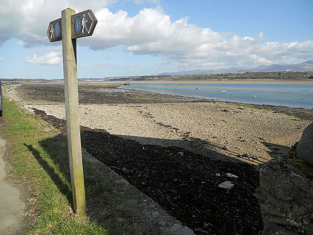
Afon Menai is a picturesque sea inlet located in the county of Anglesey, Wales. It separates the island of Anglesey from the mainland of Wales and is an important waterway connecting the Irish Sea to the larger Menai Strait. The name "Afon Menai" translates to "River Menai" in English.

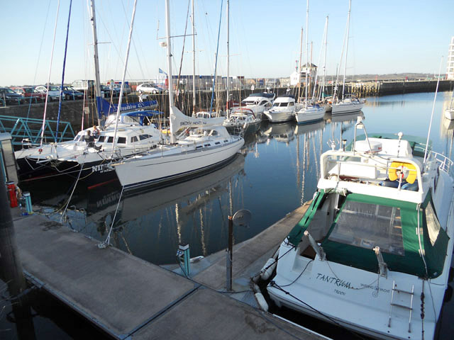
This estuary stretches approximately 25 kilometers in length, with its mouth opening into the Irish Sea near the town of Beaumaris. The waterway is characterized by its strong tidal currents, which can reach speeds of up to 8 knots during peak times. These currents make Afon Menai a popular destination for watersport enthusiasts, such as sailors, kayakers, and windsurfers, who enjoy challenging themselves in its dynamic environment.

The estuary is also home to a diverse range of wildlife. Its shores are lined with saltmarshes, mudflats, and sandbanks that provide important habitats for various bird species, including oystercatchers, curlews, and herons. Seal sightings are not uncommon in the area, as they are known to frequent the estuary's waters.

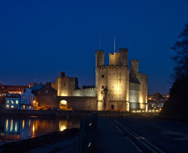
Afon Menai has played a significant role in the history of the region. It has served as a strategic waterway for trade and transportation, allowing ships to access the important port of Caernarfon. The iconic Menai Suspension Bridge, built in 1826 by Thomas Telford, spans the estuary, connecting the Isle of Anglesey to the mainland. This architectural marvel is a popular tourist attraction, offering stunning views of the surrounding area.

Overall, Afon Menai is a beautiful and dynamic waterway that combines natural beauty, recreational opportunities, and historical significance, making it a significant part of the Welsh landscape.

If you have any feedback on the listing, please let us know in the comments section below.

Afon Menai Images

Images are sourced within 2km of 53.155979/-4.2824745 or Grid Reference SH4764. Thanks to Geograph Open Source API. All images are credited.

Illuminated castle
Illuminated castle
Pivot benchmark on quay wall, Caernarfon This pivot benchmark is on the water facing wall of Caernarfon quay just in front of the white bollard. As it is water facing it can only be safely observed from the opposite bank of Afon Seiont. The mark is not shown in the current Ordnance Survey database but is shown on a 1901 map of the area at a height of 9.8ft above the Liverpool datum.
Pivot benchmark on quay wall, Caernarfon
This pivot benchmark is on the water facing wall of Caernarfon quay just in front of the white bollard. As it is water facing it can only be safely observed from the opposite bank of Afon Seiont. The mark is not shown in the current Ordnance Survey database but is shown on a 1901 map of the area at a height of 9.8ft above the Liverpool datum.
Rivet benchmark on wall at base of the black tower of Caernarfon Castle, Caernarfon This rivet benchmark is located on a low wall at the base of the black tower of Caernarfon castle & it is shown in the current Ordnance Survey database at a height of 5.2300m above the Newlyn datum.
Rivet benchmark on wall at base of the black tower of Caernarfon Castle, Caernarfon
This rivet benchmark is located on a low wall at the base of the black tower of Caernarfon castle & it is shown in the current Ordnance Survey database at a height of 5.2300m above the Newlyn datum.
Victoria Dock
Victoria Dock
Walking route beside the Menai Straits
Tide out at Barras
Tide out at Barras
Inner Walls of Caernarfon Castle
An old concrete 6 mile railway milepost besides cycle track, Caernarfon A relic of the old railway line which once ran along what is now a cycle track.
An old concrete 6 mile railway milepost besides cycle track, Caernarfon
A relic of the old railway line which once ran along what is now a cycle track.
Harbour Offices, Caernarfon Offices of the Caernarfon Harbour Trust, which was established in 1793.

From the Trust's web site, "Caernarfon Harbour Trust is the authority responsible for the control of navigation and the provision and maintenance of navigational aids in the area from Britannia Bridge to Caernarfon Bay. It is also the competent Harbour Authority responsible for the provision of pilotage throughout the Menai Strait.  The Trust provides and maintains a number of moorings in the River Seiont and Port Dinorwic. Additionally, it also serves as manager for Victoria Dock Marina, Caernarfon."
Harbour Offices, Caernarfon
Offices of the Caernarfon Harbour Trust, which was established in 1793. From the Trust's web site, "Caernarfon Harbour Trust is the authority responsible for the control of navigation and the provision and maintenance of navigational aids in the area from Britannia Bridge to Caernarfon Bay. It is also the competent Harbour Authority responsible for the provision of pilotage throughout the Menai Strait. The Trust provides and maintains a number of moorings in the River Seiont and Port Dinorwic. Additionally, it also serves as manager for Victoria Dock Marina, Caernarfon."
The TARDIS lands at the Castle, Caernarfon
The TARDIS materialises on the Queen's Gate at the Castle, Caernarfon
Bicycles are not allowed on the promenade, Caernarfon This sign is located within the arch of Porth-yr-aur in Caernarfon. As this sign is not bi-lingual and has the defunct spelling of Caernarfon it is quite likely a very old sign.
Bicycles are not allowed on the promenade, Caernarfon
This sign is located within the arch of Porth-yr-aur in Caernarfon. As this sign is not bi-lingual and has the defunct spelling of Caernarfon it is quite likely a very old sign.
Datestone at Yr Eglwys Fethodistaidd Ebeneser, Caernarfon Was built in 1826 and later extended in 1840. See also: <a href="https://www.geograph.org.uk/photo/2303475">SH4862 : Yr Eglwys Fethodistaidd Ebeneser, Caernarfon</a>
Datestone at Yr Eglwys Fethodistaidd Ebeneser, Caernarfon
Was built in 1826 and later extended in 1840. See also: SH4862 : Yr Eglwys Fethodistaidd Ebeneser, Caernarfon
Morgan Lloyd, Caernarfon
Morgan Lloyd pub on Castle Square (Y Maes), Caernarfon
The Four Alls, Caernarfon
The Four Alls pub on Hole in the Wall Street, Caernarfon
Y Goron on Stryd Fawr, Caernarfon
Show me another place!

Afon Menai is located at Grid Ref: SH4764 (Lat: 53.155979, Lng: -4.2824745)

Unitary Authority: Isle of Anglesey

Police Authority: North Wales

Also known as: Menai Strait

What 3 Words

///input.sends.buns. Near Caernarfon, Gwynedd

Nearby Locations

Afon Menai Menai Strait

Related Wikis

Anglesey Sea Zoo

The Anglesey Sea Zoo (Welsh: Sw Môr Môn) is an aquarium and independent research and marine education centre on the south coast of Anglesey island in North...

Afon Seiont

Afon Seiont (Welsh, meaning 'River Seiont' in English) is a river in Gwynedd, Wales which runs into the Menai Strait. Its source is the outflow of Llyn...

Caernarvon railway station

Caernarvon railway station was a station on the former Bangor and Carnarvon Railway between Caernarfon, Gwynedd and Menai Suspension Bridge near Bangor...

Llŷn Coastal Path

The Llŷn Coastal Path (Welsh: Llwybr Arfordir Llŷn) is a waymarked 146-kilometre (91 mi) long-distance footpath running along the coast of the Llŷn Peninsula...

Related Videos

Beautiful Caernarfon North Wales,UK Walking Tour in Winter

Caernarfon Town in Wales Caernarfon is a royal town, community and port in Gwynedd, Wales. Caernarfon is home to Wales' ...

Cwtch@Hafod Making Happy Holiday Memories August 2021

3 gorgeous glamping getaways. 2 shepherd's huts. 1 cabin.Each one with hot tubs. 1 small personal reliable business owner.

Caernarfon Castle Visit. #travel #caernarfon #caernarfoncastle #uk

visited Caernarfon Castle with the family. April 2023.

Nearby Amenities

Located within 500m of 53.155979,-4.2824745
Source: PGS
Lat/Long: 53.1533553/-4.2883674
Source: PGS
Lat/Long: 53.1534582/-4.2881152
Source: PGS
Lat/Long: 53.1535644/-4.2878148
Source: PGS
Lat/Long: 53.1536737/-4.2875734
Source: PGS
Lat/Long: 53.153751/-4.2874232
Source: PGS
Lat/Long: 53.1541016/-4.2866668
Created By: almien_coastlines
Source: PGS
Lat/Long: 53.154316/-4.285586
Created By: almien_coastlines
Source: PGS
Lat/Long: 53.154447/-4.285377
Created By: almien_coastlines
Source: PGS
Lat/Long: 53.154838/-4.284749
Created By: almien_coastlines
Source: PGS
Lat/Long: 53.155098/-4.284331
Source: PGS
Lat/Long: 53.1554179/-4.2835939
Source: PGS
Lat/Long: 53.1557653/-4.2824351
Created By: almien_coastlines
Source: PGS
Lat/Long: 53.156923/-4.281401
Created By: almien_coastlines
Source: PGS
Lat/Long: 53.157571/-4.280782
Created By: almien_coastlines
Source: PGS
Lat/Long: 53.157701/-4.280572
Created By: almien_coastlines
Source: PGS
Lat/Long: 53.157832/-4.280364
Created By: almien_coastlines
Source: PGS
Lat/Long: 53.158478/-4.279743
Created By: almien_coastlines
Source: PGS
Lat/Long: 53.158609/-4.279534
Created By: almien_coastlines
Source: PGS
Lat/Long: 53.159645/-4.278498
Foel
Is In: Anglesey
Place: hamlet
Lat/Long: 53.1572904/-4.2851919
Post Box
Collection Times: Mo-Fr 10:45; Sa 10:30
Operator: Royal Mail
Operator Wikidata: Q638098
Post Box Type: lamp
Ref: LL61 56
Royal Cypher: EIIR
Royal Cypher Wikidata: Q33102113
Lat/Long: 53.1591902/-4.2801672
The data included in this document is from www.openstreetmap.org. The data is made available under ODbL.

Have you been to Afon Menai?

Leave your review of Afon Menai below (or comments, questions and feedback).