Ferry Channel

Sea, Estuary, Creek in Sussex Chichester

England

Ferry Channel

Pagham - View across the lagoon Looking westwards across Pagham Lagoon from the wooden bridge seen in <a href="https://www.geograph.org.uk/photo/7180809">SZ8897 : Pagham Lagoon bridge</a>
Pagham - View across the lagoon Credit: Rob Farrow

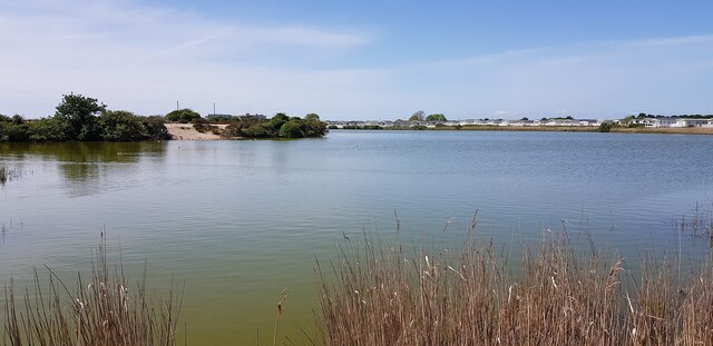
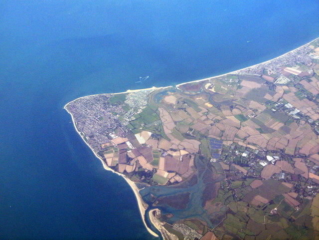
Ferry Channel is a prominent waterway located in Sussex, England. It serves as a crucial sea, estuary, and creek, providing essential transportation and recreational opportunities for the local community and visitors alike.

As a sea channel, Ferry Channel connects the English Channel to the vast expanse of the Sussex coast. It plays a pivotal role in maritime trade and serves as a gateway for cargo ships and ferries traveling to and from the nearby ports. This strategic location makes it a vital transportation link, facilitating the movement of goods and people to various destinations.

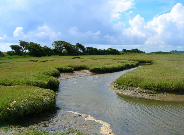
The channel also functions as an estuary, where freshwater from rivers such as the River Adur and River Arun mix with seawater. This unique blend creates a diverse ecosystem that supports a wide array of marine life. Fish, crustaceans, and birds thrive in this estuarine environment, attracting nature enthusiasts and birdwatchers who come to observe the diverse wildlife.

Furthermore, Ferry Channel transforms into a picturesque creek as it winds its way through the Sussex countryside. The calm and tranquil waters provide a perfect setting for boating, kayaking, and other water-based activities. The creek's banks are often lined with lush vegetation, offering a serene and scenic backdrop for those exploring its meandering path.

Overall, Ferry Channel in Sussex is a multi-functional waterway, serving as a sea channel, estuary, and creek. It serves as a vital transportation route, supports a diverse ecosystem, and offers recreational opportunities for both locals and tourists.

If you have any feedback on the listing, please let us know in the comments section below.

Ferry Channel Images

Images are sourced within 2km of 50.764295/-0.77114439 or Grid Reference SZ8696. Thanks to Geograph Open Source API. All images are credited.

Pagham - View across the lagoon Looking westwards across Pagham Lagoon from the wooden bridge seen in <a href="https://www.geograph.org.uk/photo/7180809">SZ8897 : Pagham Lagoon bridge</a>
Pagham - View across the lagoon
Looking westwards across Pagham Lagoon from the wooden bridge seen in SZ8897 : Pagham Lagoon bridge
Pagham Lagoon bridge This wooden bridge is situated at the eastern end of Pagham Lagoon. For the view westwards from this bridge, see <a href="https://www.geograph.org.uk/photo/7180780">SZ8897 : Pagham - View across the lagoon</a>
Pagham Lagoon bridge
This wooden bridge is situated at the eastern end of Pagham Lagoon. For the view westwards from this bridge, see SZ8897 : Pagham - View across the lagoon
Pagham - Church of St Thomas a Becket The church of St Thomas a Becket is situated towards the western extremity of the village of Pagham. Originally dating from the C11th it was heavily restored by John Elliott in 1837.
It is EH Grade I listed.
<span class="nowrap"><a title="https://historicengland.org.uk/listing/the-list/list-entry/1353902?section=official-list-entry" rel="nofollow ugc noopener" href="https://historicengland.org.uk/listing/the-list/list-entry/1353902?section=official-list-entry">Link</a><img style="margin-left:2px;" alt="External link" title="External link - shift click to open in new window" src="https://s1.geograph.org.uk/img/external.png" width="10" height="10"/></span>
See also <a href="https://www.geograph.org.uk/photo/7180813">SZ8897 : Pagham - Church of St Thomas a Becket - pathway and spire</a>
Pagham - Church of St Thomas a Becket
The church of St Thomas a Becket is situated towards the western extremity of the village of Pagham. Originally dating from the C11th it was heavily restored by John Elliott in 1837. It is EH Grade I listed. LinkExternal link See also SZ8897 : Pagham - Church of St Thomas a Becket - pathway and spire
Pagham - Church of St Thomas a Becket - pathway and spire This pathway leads from the gates on Church Lane, Pagham to the broached shingled spire of the Church of St Thomas a Becket.
See also <a href="https://www.geograph.org.uk/photo/7180810">SZ8897 : Pagham - Church of St Thomas a Becket</a>
Pagham - Church of St Thomas a Becket - pathway and spire
This pathway leads from the gates on Church Lane, Pagham to the broached shingled spire of the Church of St Thomas a Becket. See also SZ8897 : Pagham - Church of St Thomas a Becket
Pagham - The Old Cottage This newly re-thatched cottage on Church Lane in Pagham dates from the C18th - it is directly opposite <a href="https://www.geograph.org.uk/photo/7180810">SZ8897 : Pagham - Church of St Thomas a Becket</a>
It is EH Grade II listed: <span class="nowrap"><a title="https://historicengland.org.uk/listing/the-list/list-entry/1027612?section=official-list-entry" rel="nofollow ugc noopener" href="https://historicengland.org.uk/listing/the-list/list-entry/1027612?section=official-list-entry">Link</a><img style="margin-left:2px;" alt="External link" title="External link - shift click to open in new window" src="https://s1.geograph.org.uk/img/external.png" width="10" height="10"/></span>
Pagham - The Old Cottage
This newly re-thatched cottage on Church Lane in Pagham dates from the C18th - it is directly opposite SZ8897 : Pagham - Church of St Thomas a Becket It is EH Grade II listed: LinkExternal link
Pagham - Becket's Barn Becket's Barn is an EH Grade II listed <span class="nowrap"><a title="https://historicengland.org.uk/listing/the-list/list-entry/1234325?section=official-list-entry" rel="nofollow ugc noopener" href="https://historicengland.org.uk/listing/the-list/list-entry/1234325?section=official-list-entry">Link</a><img style="margin-left:2px;" alt="External link" title="External link - shift click to open in new window" src="https://s1.geograph.org.uk/img/external.png" width="10" height="10"/></span> mediæval barn southeast of <a href="https://www.geograph.org.uk/photo/7180810">SZ8897 : Pagham - Church of St Thomas a Becket</a> and now surrounded by the Church Farm Caravan Holiday Park on Church Lane, Pagham who use the building as one of their administrative buildings including visitor reception.
Pagham - Becket's Barn
Becket's Barn is an EH Grade II listed LinkExternal link mediæval barn southeast of SZ8897 : Pagham - Church of St Thomas a Becket and now surrounded by the Church Farm Caravan Holiday Park on Church Lane, Pagham who use the building as one of their administrative buildings including visitor reception.
Pagham Harbour North of Selsey and Selsey Bill, from just south of Bognor Regis.
Pagham Harbour
North of Selsey and Selsey Bill, from just south of Bognor Regis.
Solar farm by Bakers Farm The edge of a large array.
Solar farm by Bakers Farm
The edge of a large array.
Pagham Harbour visitor centre The long-standing and popular reserve is now run by the RSPB, with financial support from West Sussex County Council, who previously ran the reserve. It is now paired with Medmerry RSPB reserve, the managed retreat area the other side of Selsey.
Pagham Harbour visitor centre
The long-standing and popular reserve is now run by the RSPB, with financial support from West Sussex County Council, who previously ran the reserve. It is now paired with Medmerry RSPB reserve, the managed retreat area the other side of Selsey.
Ferry Channel entering Pagham Harbour
Path by Ferry Long Pool Between the visitor centre and Church Norton.
Path by Ferry Long Pool
Between the visitor centre and Church Norton.
Pagham Harbour Ferry Channel entering the harbour.
Pagham Harbour
Ferry Channel entering the harbour.
Saltmarsh, Pagham Harbour
Path by Pagham Harbour A wonderful area to watch the tide rise, the period between mid tide and three quarters high being the most interesting.
Path by Pagham Harbour
A wonderful area to watch the tide rise, the period between mid tide and three quarters high being the most interesting.
Pagham Harbour
Pagham Harbour
Path by Pagham Harbour It pays to know the tides here, both for the wildlife and for areas like this that get covered by high tides.
Path by Pagham Harbour
It pays to know the tides here, both for the wildlife and for areas like this that get covered by high tides.
Rising tide in Pagham Harbour Watching the tide rise in Pagham Harbour, and the wading birds and waterfowl move with it, is always special. Most of the mud gets covered between mid tide and three quarters high.
Rising tide in Pagham Harbour
Watching the tide rise in Pagham Harbour, and the wading birds and waterfowl move with it, is always special. Most of the mud gets covered between mid tide and three quarters high.
Show me another place!

Ferry Channel is located at Grid Ref: SZ8696 (Lat: 50.764295, Lng: -0.77114439)

Administrative County: West Sussex

District: Chichester

Police Authority: Sussex

What 3 Words

///crisper.irritable.below. Near Selsey, West Sussex

Nearby Locations

Ferry Channel

Related Wikis

Pagham Harbour

Pagham Harbour is a 629-hectare (1,550-acre) biological and geological Site of Special Scientific Interest on the western outskirts of Bognor Regis in...

RAF Selsey

Royal Air Force Selsey or more simply RAF Selsey is a former Royal Air Force Advanced Landing Ground located 2 miles north east of Selsey, West Sussex...

St Wilfrid's Chapel, Church Norton

St Wilfrid's Chapel, also known as St Wilfrid's Church and originally as St Peter's Church, is a former Anglican church at Church Norton, a rural location...

Selsey Abbey

Selsey Abbey was founded by St Wilfrid in AD 681 on land donated at Selsey by the local Anglo-Saxon ruler, King Æðelwealh of Sussex, Sussex's first Christian...

Nearby Amenities

Located within 500m of 50.764295,-0.77114439
Yeatman's Barn
Historic Place: farm
Source: OS OpenData StreetView
Lat/Long: 50.7686515/-0.7716227
The data included in this document is from www.openstreetmap.org. The data is made available under ODbL.

Have you been to Ferry Channel?

Leave your review of Ferry Channel below (or comments, questions and feedback).