Skinburness Creek

Sea, Estuary, Creek in Cumberland Allerdale

England

Skinburness Creek

Groyne and beach at Skinburness
Groyne and beach at Skinburness Credit: Oliver Dixon

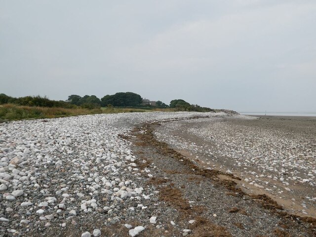
Skinburness Creek is a picturesque waterway located in Cumberland, a district in the county of Cumbria, England. It is a tidal creek that flows into the Solway Firth, a large estuary on the Irish Sea. The creek extends for approximately 3 miles and is surrounded by breathtaking natural beauty.

The creek is characterized by its tranquil and serene atmosphere, offering visitors a peaceful retreat from the bustling city life. The water is crystal clear and reflects the surrounding landscape, which is dominated by lush greenery and rolling hills.

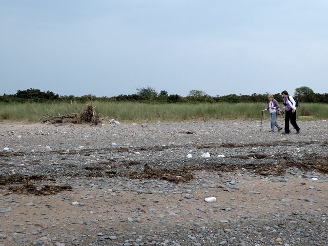
The estuary is home to a diverse range of flora and fauna, making it a haven for nature enthusiasts and wildlife lovers. Visitors often spot a variety of bird species, including herons, egrets, and oystercatchers, as well as seals and otters swimming in the creek.

Skinburness Creek is also an important site for recreational activities such as fishing and boating. Anglers are drawn to its waters, which are abundant in various fish species, including salmon, sea trout, and flounder. Boating enthusiasts can explore the creek and enjoy the stunning coastal views.

The creek is easily accessible, with a well-maintained footpath running alongside it, providing visitors with the opportunity to take leisurely walks and admire the breathtaking scenery. It is a popular destination for both locals and tourists seeking a tranquil escape in the heart of Cumberland.

If you have any feedback on the listing, please let us know in the comments section below.

Skinburness Creek Images

Images are sourced within 2km of 54.903567/-3.3417597 or Grid Reference NY1457. Thanks to Geograph Open Source API. All images are credited.

Groyne and beach at Skinburness
Shingle beach at Skinburness It is apparent that the shore has retreated by about 100 metres since the OS 1:25,000 map was made.
Shingle beach at Skinburness
It is apparent that the shore has retreated by about 100 metres since the OS 1:25,000 map was made.
Shingle beach on the Grune peninsula It is apparent that the shore has retreated by about 100 metres since the OS 1:25,000 map was made.
Shingle beach on the Grune peninsula
It is apparent that the shore has retreated by about 100 metres since the OS 1:25,000 map was made.
Track and gate on the south side of the Grune peninsula
Shingle beach on the Grune peninsula
Shingle beach at Grune Cast
Shingle beach at Grune Point On the far side of Moricambe Bay, it is possible to make out the masts of the Anthorn Radio Station <a href="https://www.geograph.org.uk/gridref/NY1757">NY1757</a>.
Shingle beach at Grune Point
On the far side of Moricambe Bay, it is possible to make out the masts of the Anthorn Radio Station NY1757.
Dewpond on Grune Point
Skinburness Creek Seen from Grune Point looking over to Tickhill Scar.
Skinburness Creek
Seen from Grune Point looking over to Tickhill Scar.
Pillbox on Grune Point Or to give its full title "Cumberland Machine-Gun and Anti-Tank Rifle Emplacement". Uniquely constructed from sandbags filled with concrete; the hessian of the sacks has rotted away long since. The cairn on the top is a memorial to four firemen who drowned in an open boat in December 1956 during a rescue attempt following a report of a wildfowler stranded on the marshes. The report subsequently prove to be a false alarm.
Pillbox on Grune Point
Or to give its full title "Cumberland Machine-Gun and Anti-Tank Rifle Emplacement". Uniquely constructed from sandbags filled with concrete; the hessian of the sacks has rotted away long since. The cairn on the top is a memorial to four firemen who drowned in an open boat in December 1956 during a rescue attempt following a report of a wildfowler stranded on the marshes. The report subsequently prove to be a false alarm.
Interior of the Grune Point pillbox The roof is supported by a central pillar. For further detail see <a href="https://www.geograph.org.uk/photo/6960697">NY1456 : Pillbox on Grune Point</a>.
Interior of the Grune Point pillbox
The roof is supported by a central pillar. For further detail see NY1456 : Pillbox on Grune Point.
Dicktrod Lane, Skinburness Indicated on the sign to be a private road, Dicktrod Lane (Dick Trod Lane on Ordnance Survey Maps) was an established right of way between Skinburness and the shore at Skinburnessbank long before the housing estate it now serves was built.
Dicktrod Lane, Skinburness
Indicated on the sign to be a private road, Dicktrod Lane (Dick Trod Lane on Ordnance Survey Maps) was an established right of way between Skinburness and the shore at Skinburnessbank long before the housing estate it now serves was built.
Grune Cast On the sands of Grune Cast couple of walkers are taking photographs looking across the Solway Firth to Scotland.
In the left background is Criffel, 569m (1869ft) with its subsidiary summit of Knockendoch.
Grune Cast
On the sands of Grune Cast couple of walkers are taking photographs looking across the Solway Firth to Scotland. In the left background is Criffel, 569m (1869ft) with its subsidiary summit of Knockendoch.
The Cumbria Coastal Way at Guards Beside the Solway Firth, the sea defences that protect the coast north-east from Silloth and along Skinburness Bank end abruptly at Guards.  Coastal erosion has occurred beyond this point cutting the public footpath to Grune Point thus forcing walkers onto the shingle beach.
Grune House is in the right background.
The Cumbria Coastal Way at Guards
Beside the Solway Firth, the sea defences that protect the coast north-east from Silloth and along Skinburness Bank end abruptly at Guards. Coastal erosion has occurred beyond this point cutting the public footpath to Grune Point thus forcing walkers onto the shingle beach. Grune House is in the right background.
The Solway Firth Viewed across the Solway Firth from the beach at Guards, a slow moving April shower is moving south eastwards over Dumfriesshire.
The Solway Firth
Viewed across the Solway Firth from the beach at Guards, a slow moving April shower is moving south eastwards over Dumfriesshire.
Grune Point Some of the masts of Anthorn Radio Station are on the far side of Moricambe Bay.  In the far distance is Cold Fell (621m) marking the northernmost extremity of the Pennines.
Grune Point
Some of the masts of Anthorn Radio Station are on the far side of Moricambe Bay. In the far distance is Cold Fell (621m) marking the northernmost extremity of the Pennines.
Coastal path near Grune House The Cumbria Coastal Way passes between banks of gorse bushes north of Grune House.
Coastal path near Grune House
The Cumbria Coastal Way passes between banks of gorse bushes north of Grune House.
Coastal path near Grune House The Cumbria Coastal Way passes between banks of gorse bushes near Grune House.
Coastal path near Grune House
The Cumbria Coastal Way passes between banks of gorse bushes near Grune House.
Show me another place!

Skinburness Creek is located at Grid Ref: NY1457 (Lat: 54.903567, Lng: -3.3417597)

Administrative County: Cumbria

District: Allerdale

Police Authority: Cumbria

What 3 Words

///result.escalated.repair. Near Silloth, Cumbria

Related Wikis

River Wampool

The River Wampool is a river flowing through north western Cumbria in England. It is in the Waver and Wampool (or Wampool and Waver) catchment which includes...

Milefortlet 9

Milefortlet 9 (Skinburness) was a Milefortlet of the Roman Cumbrian Coast defences. These milefortlets and intervening stone watchtowers extended from...

Moricambe Bay

Moricambe Bay is an inlet of the Solway Firth in Cumbria (before 1974 in Cumberland) in north west England, created by the confluence of two rivers, the...

Skinburness

Skinburness is a village in Cumbria (historically Cumberland), England. It forms a residential area for the town of Silloth, and is about 10 miles west...

Nearby Amenities

Located within 500m of 54.903567,-3.3417597
Stenor Scar
Place: locality
Lat/Long: 54.9053378/-3.3458343
Grune Cast
Place: locality
Lat/Long: 54.9000697/-3.3428517
The data included in this document is from www.openstreetmap.org. The data is made available under ODbL.

Have you been to Skinburness Creek?

Leave your review of Skinburness Creek below (or comments, questions and feedback).