Auchencairn Lane

Sea, Estuary, Creek in Kirkcudbrightshire

Scotland

Auchencairn Lane

Rocks on the foreshore of Auchencairn Bay The various post on the beach are the remnants of salmon fishing nets.
How it might have looked. <a title="https://www.geograph.org.uk/photo/2242476" href="https://www.geograph.org.uk/photo/2242476">Link</a> and 
<a title="https://www.geograph.org.uk/photo/2242518" href="https://www.geograph.org.uk/photo/2242518">Link</a>
Hestan Island in the bay.
Rocks on the foreshore of Auchencairn Bay Credit: Russel Wills

Auchencairn Lane is a picturesque coastal road located in Kirkcudbrightshire, Scotland. The lane stretches along the coastline, offering stunning views of the sea, estuary, and creek that surround the area.

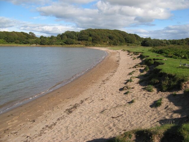
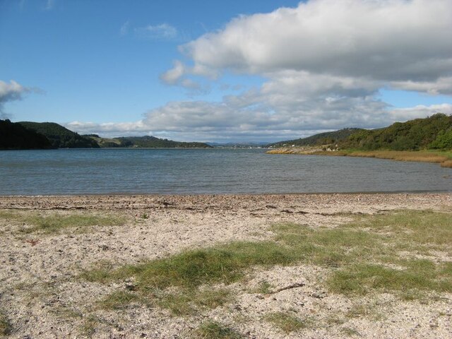
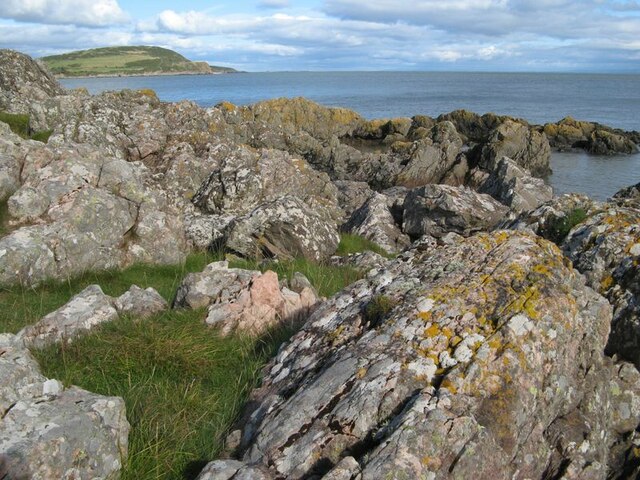
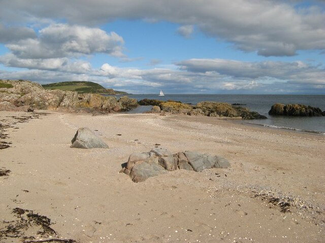
Situated on the Solway Firth, the lane provides an idyllic setting, with the sea gently lapping against the shore. The calm and peaceful atmosphere is enhanced by the beautiful natural scenery that surrounds the area. The pristine sandy beaches and rocky cliffs create a perfect backdrop for nature enthusiasts and photographers alike.

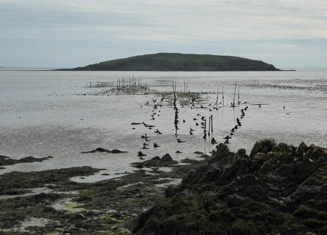
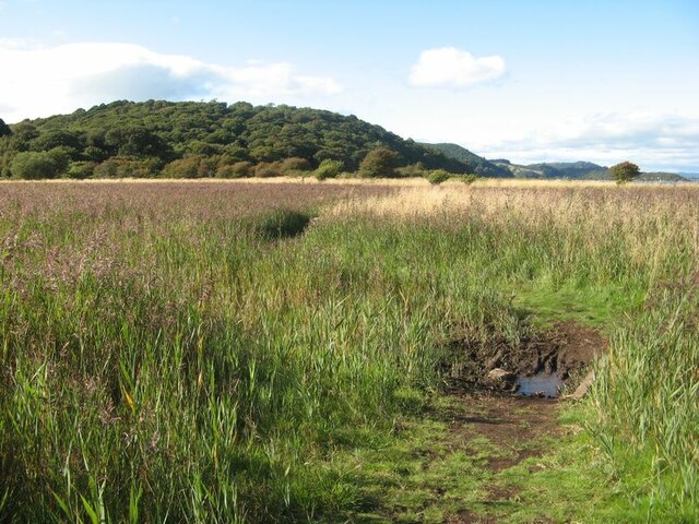
A highlight of Auchencairn Lane is the estuary, which is formed by the River Dee as it flows into the sea. This tidal inlet is a haven for wildlife, attracting a diverse range of bird species, such as herons and oystercatchers. The estuary also supports a rich ecosystem of marine life, including seals and various species of fish.

As you continue along the lane, you will come across a small creek, which adds to the charm of the area. The creek meanders through the landscape, providing a tranquil spot for fishing or simply enjoying the peaceful surroundings.

Auchencairn Lane is a popular destination for visitors and locals alike, who come to appreciate the natural beauty and serenity of the area. Whether you are looking for a relaxing stroll along the coast or a place to enjoy the breathtaking views, Auchencairn Lane is sure to leave a lasting impression.

If you have any feedback on the listing, please let us know in the comments section below.

Auchencairn Lane Images

Images are sourced within 2km of 54.846245/-3.8278911 or Grid Reference NX8251. Thanks to Geograph Open Source API. All images are credited.

Rocks on the foreshore of Auchencairn Bay The various post on the beach are the remnants of salmon fishing nets.
How it might have looked. <a title="https://www.geograph.org.uk/photo/2242476" href="https://www.geograph.org.uk/photo/2242476">Link</a> and 
<a title="https://www.geograph.org.uk/photo/2242518" href="https://www.geograph.org.uk/photo/2242518">Link</a>
Hestan Island in the bay.
Rocks on the foreshore of Auchencairn Bay
The various post on the beach are the remnants of salmon fishing nets. How it might have looked. Link and Link Hestan Island in the bay.
Balcary Fishery and Hestan Island
Balcary Bay The wooded peninsula of Torr Point <a href="https://www.geograph.org.uk/gridref/NX8251">NX8251</a> on the far side of the bay with   Almorness Point <a href="https://www.geograph.org.uk/gridref/NX8351">NX8351</a> further away and to the right.
Balcary Bay
The wooded peninsula of Torr Point NX8251 on the far side of the bay with Almorness Point NX8351 further away and to the right.
Balcary fishery, Auchencairn Bay
Balcary fishery, Auchencairn Bay, high tide
Auchencairn Bay from the south
A casualty on Hestan Island The bones of a sheep lie below steep slopes at the southwest corner of the island.
A casualty on Hestan Island
The bones of a sheep lie below steep slopes at the southwest corner of the island.
Auchencairn Bay
Auchencairn Bay
Grazing cows Looking over pastures towards Rough Firth.
Grazing cows
Looking over pastures towards Rough Firth.
Horse Isles Bay A surprising and secluded bay on the east side of Almorness.
Horse Isles Bay
A surprising and secluded bay on the east side of Almorness.
Rough Firth from Horse Isles Bay Looking northwards across the bay and onto Rough Firth.
Rough Firth from Horse Isles Bay
Looking northwards across the bay and onto Rough Firth.
Reed bed The marshy area of the merse is occupied by a wonderful reed bed.
Reed bed
The marshy area of the merse is occupied by a wonderful reed bed.
Rocks on Almorness Lichen-encrusted rocks form the shore to west of White Port. Pink-coloured granitic veins give variety to an otherwise rather grey area.
Rocks on Almorness
Lichen-encrusted rocks form the shore to west of White Port. Pink-coloured granitic veins give variety to an otherwise rather grey area.
White Port A view of the east end of the pretty beach of White Port.
White Port
A view of the east end of the pretty beach of White Port.
Shoreline, Old Torr Head of Auchencairn Bay.
Shoreline, Old Torr
Head of Auchencairn Bay.
Ruin, Old Torr
Ruin, Old Torr
Show me another place!

Auchencairn Lane is located at Grid Ref: NX8251 (Lat: 54.846245, Lng: -3.8278911)

Unitary Authority: Dumfries and Galloway

Police Authority: Dumfries and Galloway

What 3 Words

///treble.pizzas.unsecured. Near Dalbeattie, Dumfries & Galloway

Related Wikis

Urr Water

Urr Water or River Urr (arc. River Orr) is a river in which flows through the counties of Dumfriesshire and Kirkcudbrightshire in southwest Scotland....

Hestan Island

Hestan Island is a small coastal island at the southern foot of the River Urr estuary in the Solway Firth, in the historical county of Kirkcudbrightshire...

Rough Island, Scotland

"Rough Island" is also used as a translation of "Garbh Eilean", a common Scottish name for islandsRough Island is a 20-acre (8 ha) uninhabited tidal island...

Orchardton Castle

Orchardton Castle overlooks the Solway Coast. Built in the 1880s, this is a Grade B listed property formerly known as Orchardton House. Built around a...

Nearby Amenities

Located within 500m of 54.846245,-3.8278911
Source: PGS
Lat/Long: 54.8462072/-3.8354204
Source: PGS
Lat/Long: 54.8468185/-3.8352286
Source: PGS
Lat/Long: 54.8469691/-3.8354433
Source: PGS
Lat/Long: 54.8506934/-3.8268992
Source: PGS
Lat/Long: 54.8503639/-3.8267737
Source: PGS
Lat/Long: 54.8501437/-3.8265232
Source: PGS
Lat/Long: 54.8499278/-3.8262426
Source: PGS
Lat/Long: 54.8497268/-3.8260383
Source: PGS
Lat/Long: 54.8495566/-3.8256831
Source: PGS
Lat/Long: 54.8493815/-3.8254213
Source: PGS
Lat/Long: 54.849194/-3.8253028
Source: PGS
Lat/Long: 54.849059/-3.8249981
Source: PGS
Lat/Long: 54.8489102/-3.8246451
Source: PGS
Lat/Long: 54.8487984/-3.8242819
Source: PGS
Lat/Long: 54.8486458/-3.8239107
Source: PGS
Lat/Long: 54.8484525/-3.8236151
Source: PGS
Lat/Long: 54.8481547/-3.8233367
Source: PGS
Lat/Long: 54.8479299/-3.8231946
Source: PGS
Lat/Long: 54.8475345/-3.8231999
Source: PGS
Lat/Long: 54.8471553/-3.8232712
Source: PGS
Lat/Long: 54.8468659/-3.8229864
Source: PGS
Lat/Long: 54.8470089/-3.8225374
Source: PGS
Lat/Long: 54.8467256/-3.8215847
Source: PGS
Lat/Long: 54.8465218/-3.8212612
Source: PGS
Lat/Long: 54.846195/-3.8203589
The data included in this document is from www.openstreetmap.org. The data is made available under ODbL.

Have you been to Auchencairn Lane?

Leave your review of Auchencairn Lane below (or comments, questions and feedback).