Caolas Eilean an Ruadhaidh
Sea, Estuary, Creek in Argyllshire
Scotland
Caolas Eilean an Ruadhaidh

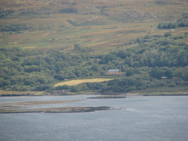
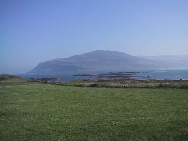
Caolas Eilean an Ruadhaidh is a stunning sea inlet located in Argyllshire, Scotland. Situated on the west coast of Scotland, this picturesque area is known for its natural beauty and tranquil atmosphere. Caolas Eilean an Ruadhaidh is a combination of a sea, estuary, and creek, making it a unique and diverse landscape.
The inlet is surrounded by rolling hills and lush greenery, offering breathtaking views for visitors. The crystal-clear waters of the sea provide a perfect spot for various water activities like swimming, kayaking, and sailing. The calm estuary, formed where a river meets the sea, is home to a rich variety of wildlife, including seals, otters, and a wide range of bird species. Birdwatching enthusiasts will be delighted by the opportunity to observe rare and migratory birds in their natural habitat.
The creek within Caolas Eilean an Ruadhaidh adds a touch of charm to the area, with its narrow and winding waterway. It is a popular spot for fishing, attracting both locals and tourists alike. The creek is also a great place to explore by boat or canoe, allowing visitors to immerse themselves in the peaceful surroundings.
Caolas Eilean an Ruadhaidh is a haven for nature lovers and those seeking a break from the hustle and bustle of everyday life. Its serene and idyllic setting makes it a perfect destination for relaxation and rejuvenation. Whether strolling along the shoreline, watching the sunset, or enjoying the abundant wildlife, Caolas Eilean an Ruadhaidh offers a truly unforgettable experience for all who visit.
If you have any feedback on the listing, please let us know in the comments section below.
Caolas Eilean an Ruadhaidh Images
Images are sourced within 2km of 56.358221/-6.0600661 or Grid Reference NM4925. Thanks to Geograph Open Source API. All images are credited.


Caolas Eilean an Ruadhaidh is located at Grid Ref: NM4925 (Lat: 56.358221, Lng: -6.0600661)
Unitary Authority: Argyll and Bute
Police Authority: Argyll and West Dunbartonshire
What 3 Words
///hedgehog.corrosive.notched. Near Lochbuie, Argyll & Bute
Nearby Locations
Related Wikis
Loch Scridain
Loch Scridain is a 15-kilometre-long (9-mile) sea loch, with a west-south west aspect, on the western, or Atlantic coastline of the Isle of Mull, in the...

Tiroran
Tiroran is hamlet on the Isle of Mull in Argyll and Bute, Scotland. == History == In the late 18th century Tiroran House was associated with the McKinnon...

Pennyghael
Pennyghael (Scottish Gaelic: Peighinn nan Gàidheal) is a small village in the Ross of Mull, Argyll and Bute, Scotland. It is located along the A849 road...

Aird of Kinloch
Aird of Kinloch (Gaelic:An Àird) is a rocky outcrop between Loch Scridain and Loch Beg on the Isle of Mull, Argyll and Bute, Scotland. == References ==
Nearby Amenities
Located within 500m of 56.358221,-6.0600661Have you been to Caolas Eilean an Ruadhaidh?
Leave your review of Caolas Eilean an Ruadhaidh below (or comments, questions and feedback).