Bramble Creek

Sea, Estuary, Creek in Essex Tendring

England

Bramble Creek

Carpet of Bluebells, Stour Wood, Ramsey Part of the RSPB's Stour Estuary nature reserve: <span class="nowrap"><a title="https://www.rspb.org.uk/reserves-and-events/reserves-a-z/stour-estuary/" rel="nofollow ugc noopener" href="https://www.rspb.org.uk/reserves-and-events/reserves-a-z/stour-estuary/">Link</a><img style="margin-left:2px;" alt="External link" title="External link - shift click to open in new window" src="https://s1.geograph.org.uk/img/external.png" width="10" height="10"/></span>

See also <a href="https://www.geograph.org.uk/photo/7156261">TM1931 : Bluebells in Stour Wood, RSPB, Ramsey</a> for a closer view of the bluebells.
Carpet of Bluebells, Stour Wood, Ramsey Credit: Roger Jones

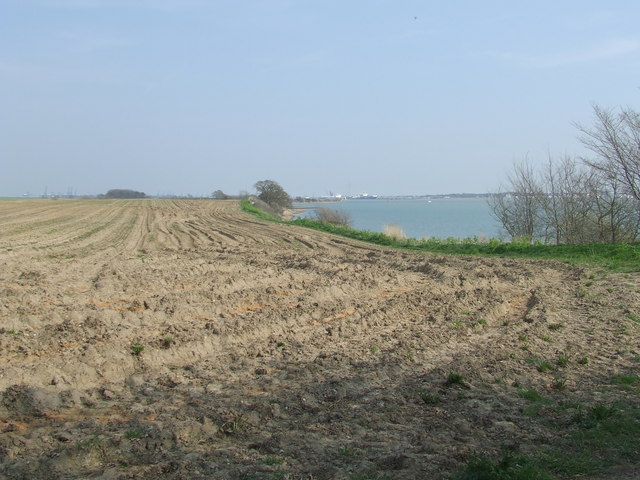
Bramble Creek is a picturesque waterway located in Essex, England. It is situated along the east coast of the county, near the towns of Harwich and Manningtree. The creek is formed by the convergence of two larger bodies of water, the North Sea and the River Stour Estuary.

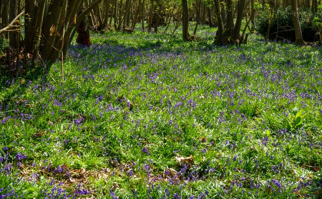
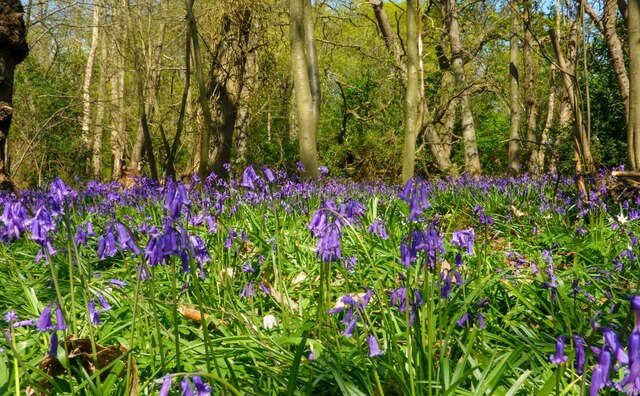
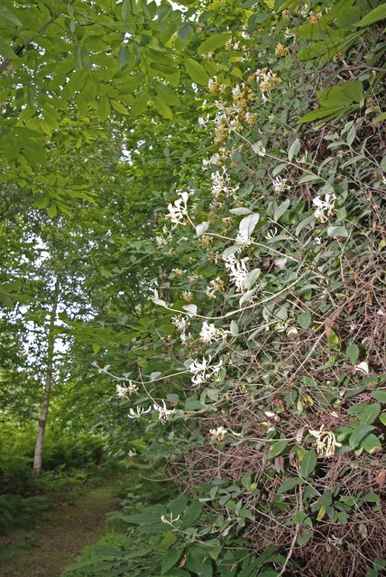
The creek is known for its stunning natural beauty and is a popular destination for nature lovers and outdoor enthusiasts. Surrounded by lush greenery and marshes, Bramble Creek offers a tranquil and serene environment for visitors to enjoy.

The creek is home to a diverse range of flora and fauna, including various species of birds, fish, and marine life. Birdwatchers frequent the area to catch a glimpse of rare and migratory birds that inhabit the creek. The surrounding marshes also provide a habitat for unique plant species, adding to the area's ecological importance.

Bramble Creek is ideal for water activities such as kayaking, canoeing, and boating. Its calm waters and gentle currents make it a suitable spot for beginners and experienced water sports enthusiasts alike. Fishing is also a popular activity in the creek, with anglers often seeking out various types of fish that inhabit its waters.

Visitors to Bramble Creek can enjoy the scenic views, take leisurely walks along the water's edge, or simply relax and soak in the natural surroundings. The creek's proximity to other attractions like historic towns and nature reserves makes it a must-visit destination for those exploring the Essex region.

If you have any feedback on the listing, please let us know in the comments section below.

Bramble Creek Images

Images are sourced within 2km of 51.941962/1.2169301 or Grid Reference TM2131. Thanks to Geograph Open Source API. All images are credited.

Carpet of Bluebells, Stour Wood, Ramsey Part of the RSPB's Stour Estuary nature reserve: <span class="nowrap"><a title="https://www.rspb.org.uk/reserves-and-events/reserves-a-z/stour-estuary/" rel="nofollow ugc noopener" href="https://www.rspb.org.uk/reserves-and-events/reserves-a-z/stour-estuary/">Link</a><img style="margin-left:2px;" alt="External link" title="External link - shift click to open in new window" src="https://s1.geograph.org.uk/img/external.png" width="10" height="10"/></span>

See also <a href="https://www.geograph.org.uk/photo/7156261">TM1931 : Bluebells in Stour Wood, RSPB, Ramsey</a> for a closer view of the bluebells.
Carpet of Bluebells, Stour Wood, Ramsey
Part of the RSPB's Stour Estuary nature reserve: LinkExternal link See also TM1931 : Bluebells in Stour Wood, RSPB, Ramsey for a closer view of the bluebells.
Bluebells in Stour Wood, RSPB, Ramsey Part of the RSPB's Stour Estuary nature reserve: <span class="nowrap"><a title="https://www.rspb.org.uk/reserves-and-events/reserves-a-z/stour-estuary/" rel="nofollow ugc noopener" href="https://www.rspb.org.uk/reserves-and-events/reserves-a-z/stour-estuary/">Link</a><img style="margin-left:2px;" alt="External link" title="External link - shift click to open in new window" src="https://s1.geograph.org.uk/img/external.png" width="10" height="10"/></span>

See also <a href="https://www.geograph.org.uk/photo/7156260">TM1931 : Carpet of Bluebells, Stour Wood, Ramsey</a> for a wider view of the area.
Bluebells in Stour Wood, RSPB, Ramsey
Part of the RSPB's Stour Estuary nature reserve: LinkExternal link See also TM1931 : Carpet of Bluebells, Stour Wood, Ramsey for a wider view of the area.
Copperas Bay on the River Stour
Suffolk Coastal & Heaths Path A small part of the Suffolk Coastal & Heaths Path with the River Stour south of Harkstead Suffolk.
Suffolk Coastal & Heaths Path
A small part of the Suffolk Coastal & Heaths Path with the River Stour south of Harkstead Suffolk.
Drift Wood Closeup of the remains of a tree beached on the shore of the River Stour along with many others washed and bleached by the weather south of Harkstead Suffolk.
Drift Wood
Closeup of the remains of a tree beached on the shore of the River Stour along with many others washed and bleached by the weather south of Harkstead Suffolk.
Side by side, rusting and rotting Laid to rest alongside each other, these two dissimilar objects, one man-made, one natural, are following their parallel paths to dissolution. The salt in the estuarial water is attacking the old pipe while it is possibly delaying the rot of the old trunk. Compare too, the subtleties of Nature's work to the plainness of Man's. (Beyond the decaying couple are the waters of the Stour, 2 hours before high tide.)
Side by side, rusting and rotting
Laid to rest alongside each other, these two dissimilar objects, one man-made, one natural, are following their parallel paths to dissolution. The salt in the estuarial water is attacking the old pipe while it is possibly delaying the rot of the old trunk. Compare too, the subtleties of Nature's work to the plainness of Man's. (Beyond the decaying couple are the waters of the Stour, 2 hours before high tide.)
Hide on the edge of Copperas Bay A quiet and remote spot yet easily walkable from Wrabness station, the facilities, apart from walking trails and a nature reserve is this roofless bird-watching hide.  There was plenty of evidence of waders and other estuarial birds around here.
Hide on the edge of Copperas Bay
A quiet and remote spot yet easily walkable from Wrabness station, the facilities, apart from walking trails and a nature reserve is this roofless bird-watching hide. There was plenty of evidence of waders and other estuarial birds around here.
Shoreline south of Nether Hall As is also the case on the opposite bank, <a href="https://www.geograph.org.uk/photo/646135">TM2031 : Horizontal woodland along the Stour</a>, the northern banks of the Stour are also scattered with fallen trees that once grew nearby.
Shoreline south of Nether Hall
As is also the case on the opposite bank, TM2031 : Horizontal woodland along the Stour, the northern banks of the Stour are also scattered with fallen trees that once grew nearby.
Seaweed-festooned old jetty Heading south from Needle Corner in <a href="https://www.geograph.org.uk/gridref/TM1934">TM1934</a>, past the abandoned Sparrow Hall, you reach the Orwell at this point, where an old jetty stands, long since abandoned.  It is not alone: <a href="https://www.geograph.org.uk/photo/660274">TM2133 : Abandoned jetty at Erwarton Ness</a>, just a little further east.
Seaweed-festooned old jetty
Heading south from Needle Corner in TM1934, past the abandoned Sparrow Hall, you reach the Orwell at this point, where an old jetty stands, long since abandoned. It is not alone: TM2133 : Abandoned jetty at Erwarton Ness, just a little further east.
Fallen soldier by abandoned jetty Lying next to <a href="https://www.geograph.org.uk/photo/661371">TM1933 : Seaweed-festooned old jetty</a>, this long-dead tree has been swung around by the tide to face the opposite direction to the one it presumably faced when it fell from a nearby bank.
Fallen soldier by abandoned jetty
Lying next to TM1933 : Seaweed-festooned old jetty, this long-dead tree has been swung around by the tide to face the opposite direction to the one it presumably faced when it fell from a nearby bank.
Footpath following field edge The footpath, following a field edge, runs parallel to the River Stour, which can be seen in the distance.
Footpath following field edge
The footpath, following a field edge, runs parallel to the River Stour, which can be seen in the distance.
What remains of a wooden jetty The rotten post emerging from the mud is part of what once used to be a wooden jetty reaching out onto the River Stour. See also > <a href="https://www.geograph.org.uk/photo/661371">TM1933 : Seaweed-festooned old jetty</a>
What remains of a wooden jetty
The rotten post emerging from the mud is part of what once used to be a wooden jetty reaching out onto the River Stour. See also > TM1933 : Seaweed-festooned old jetty
River Stour shoreline Walking east, this was the point where I realised I needed to climb up to the path by the edge of the fields.  This was after suddenly sinking almost to the knees in mud.  The map I had was ambiguous about whether the path was on the shore or not.
River Stour shoreline
Walking east, this was the point where I realised I needed to climb up to the path by the edge of the fields. This was after suddenly sinking almost to the knees in mud. The map I had was ambiguous about whether the path was on the shore or not.
Looking across the River Stour Near the end of the path from Needle Corner.
Looking across the River Stour
Near the end of the path from Needle Corner.
Field by the Stour Ready for potato planting.  (Do seaside potatoes come ready salted?...)  In the distance the port of Harwich is on the right and Felixstowe dock structures can be seen to the left.
Field by the Stour
Ready for potato planting. (Do seaside potatoes come ready salted?...) In the distance the port of Harwich is on the right and Felixstowe dock structures can be seen to the left.
View From the Hide This is the view downstream from <a href="https://www.geograph.org.uk/photo/646145">TM1931 : Hide on the edge of Copperas Bay</a> in the RSPB Stour Wood Nature Reserve.
View From the Hide
This is the view downstream from TM1931 : Hide on the edge of Copperas Bay in the RSPB Stour Wood Nature Reserve.
Stour Wood View This is the view upstream from <a href="https://www.geograph.org.uk/photo/646145">TM1931 : Hide on the edge of Copperas Bay</a> in the RSPB Stour Wood Nature Reserve.
Stour Wood View
This is the view upstream from TM1931 : Hide on the edge of Copperas Bay in the RSPB Stour Wood Nature Reserve.
Tutsan This Hypericum androsaemum was growing beside the Essex Way long distance footpath near the Stour Wood RSPB nature reserve <span class="nowrap"><a title="http://www.rspb.org.uk/reserves/guide/s/stourestuary/about.asp" rel="nofollow ugc noopener" href="http://www.rspb.org.uk/reserves/guide/s/stourestuary/about.asp">Link</a><img style="margin-left:2px;" alt="External link" title="External link - shift click to open in new window" src="https://s1.geograph.org.uk/img/external.png" width="10" height="10"/></span>
Tutsan
This Hypericum androsaemum was growing beside the Essex Way long distance footpath near the Stour Wood RSPB nature reserve LinkExternal link
Show me another place!

Bramble Creek is located at Grid Ref: TM2131 (Lat: 51.941962, Lng: 1.2169301)

Administrative County: Essex

District: Tendring

Police Authority: Essex

What 3 Words

///starring.tentacles.dancer. Near Shotley Gate, Suffolk

Nearby Locations

Bramble Creek

Related Wikis

River Stour, Suffolk

The River Stour (, pronounced rhyming with either "tour" or "sour") is a major river in East Anglia, England. It is 47 miles (76 km) long and forms most...

Copperas Wood

Copperas Wood is a 13.8-hectare (34-acre) nature reserve between Ramsey and Wrabness in Essex. It is owned and managed by the Essex Wildlife Trust, and...

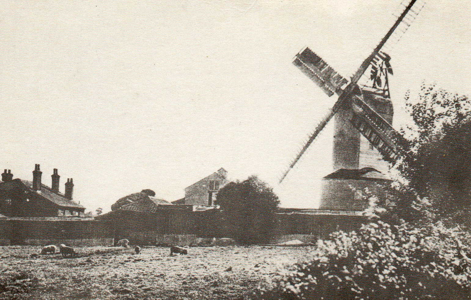
Ramsey Windmill, Essex

Ramsey Windmill is a grade II* listed post mill at Ramsey, Essex, England which has been restored. == History == Ramsey Windmill was originally built in...

Ramsey and Parkeston

Ramsey and Parkeston (formerly just Ramsey) is a civil parish in the Tendring district, in the county of Essex, England. The parish includes the villages...

Harwich refinery

Harwich refinery is a 500,000 tonnes per year refining, processing, blending and storage facility near the port of Harwich in the UK. The refinery was...

Michaelstowe Hall

Michaelstowe Hall is a manor house in the village of Ramsey near Harwich, Essex, England. The present Michaelstowe Hall dates from 1903, but the Michaelstowe...

Ramsey, Essex

Ramsey is a village on the B1352 road, in the civil parish of Ramsey and Parkeston, in the Tendring district, in the county of Essex, England. It is near...

Stour Estuary RSPB reserve

The Stour Estuary is a nature reserve in Essex, England, east of Colchester on the estuary of the River Stour, managed by the Royal Society for the Protection...

Nearby Amenities

Located within 500m of 51.941962,1.2169301
Leisure: bird_hide
Lat/Long: 51.9395104/1.2179431
Barrier: chicane
Lat/Long: 51.9396464/1.2157685
Barrier: chicane
Lat/Long: 51.9402501/1.2111022
Bench
Backrest: no
Material: wood
Lat/Long: 51.9399295/1.2145412
Bench
Backrest: no
Material: wood
Lat/Long: 51.9402349/1.2117429
The data included in this document is from www.openstreetmap.org. The data is made available under ODbL.

Have you been to Bramble Creek?

Leave your review of Bramble Creek below (or comments, questions and feedback).