Mill Head

Sea, Estuary, Creek in Essex Rochford

England

Mill Head

Great Potton farm buildings, Potton Island Although Potton Island is owned by the Ministry of Defence, much of the island has been used for farming. Taken from the mainland looking north across Potton Creek.
Great Potton farm buildings, Potton Island Credit: David Kemp

Mill Head is a picturesque area located in Essex, England. Situated along the coast, it offers stunning views of the sea, estuary, and creek. The area is known for its natural beauty and tranquil atmosphere, making it a popular destination for nature lovers and photographers.

The sea in Mill Head attracts visitors with its mesmerizing waves and vast expanse of water. The coastline is dotted with sandy beaches, providing opportunities for sunbathing, swimming, and beachcombing. The sea also offers ample opportunities for water sports such as sailing, windsurfing, and fishing.

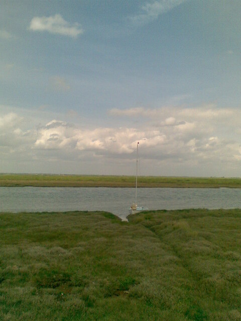
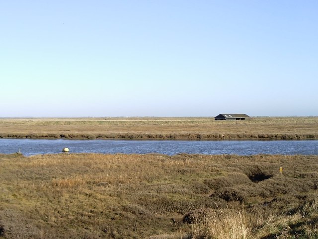
Adjacent to the sea is the estuary, where a river meets the sea. The estuary at Mill Head is characterized by its rich biodiversity, serving as a habitat for various species of birds, fish, and marine life. Birdwatchers flock to the area to witness the diverse avian population, including herons, egrets, and gulls.

A creek meanders through Mill Head, adding to the charm of the landscape. The creek provides a peaceful setting for boating and kayaking, allowing visitors to explore the intricate network of waterways and enjoy the surrounding flora and fauna.

Mill Head is also home to a variety of wildlife, including seals and dolphins that can occasionally be spotted swimming in the sea or estuary. The area's natural beauty, combined with its tranquility, makes it a haven for those seeking a peaceful retreat in the heart of nature.

In summary, Mill Head in Essex offers a delightful blend of sea, estuary, and creek, providing a haven for nature enthusiasts and those seeking a scenic getaway.

If you have any feedback on the listing, please let us know in the comments section below.

Mill Head Images

Images are sourced within 2km of 51.563238/0.81912783 or Grid Reference TQ9588. Thanks to Geograph Open Source API. All images are credited.

Great Potton farm buildings, Potton Island Although Potton Island is owned by the Ministry of Defence, much of the island has been used for farming. Taken from the mainland looking north across Potton Creek.
Great Potton farm buildings, Potton Island
Although Potton Island is owned by the Ministry of Defence, much of the island has been used for farming. Taken from the mainland looking north across Potton Creek.
From east shore of Rushley Island across Narrow Cuts towards Havengore Island View east across the saltgrass marshes from near the eastern sea wall of Rushley Island, overlooking the channel known as Narrow Cuts with the western side of Havengore Island in the background.
From east shore of Rushley Island across Narrow Cuts towards Havengore Island
View east across the saltgrass marshes from near the eastern sea wall of Rushley Island, overlooking the channel known as Narrow Cuts with the western side of Havengore Island in the background.
Oxenham's (sic) Farm Sluice This is the name given to the installation by the DoE but the farm after which it is named is referred to on OS maps and known locally as Oxenham Farm.
Oxenham's (sic) Farm Sluice
This is the name given to the installation by the DoE but the farm after which it is named is referred to on OS maps and known locally as Oxenham Farm.
Great Wakering Sea Scouts headquarters Situated below the sea-wall near Mill Head basin and overlooking Havengore Creek and Rushley Island.
Great Wakering Sea Scouts headquarters
Situated below the sea-wall near Mill Head basin and overlooking Havengore Creek and Rushley Island.
Shoebury Road Towards Great Wakering.
Shoebury Road
Towards Great Wakering.
Field and hedgerow Off Shoebury Road.
Field and hedgerow
Off Shoebury Road.
Field near Great Wakering Off Shoebury Road.
Field near Great Wakering
Off Shoebury Road.
Shoebury Road Towards Great Wakering.
Shoebury Road
Towards Great Wakering.
St Nicholas Church, Great Wakering
The Waeccer, Great Wakering On High Street.
See <a href="https://www.geograph.org.uk/photo/7271352">TQ9487 : Sign for the Waeccer, Great Wakering </a> for sign.
The Waeccer, Great Wakering
On High Street. See TQ9487 : Sign for the Waeccer, Great Wakering for sign.
Sign for the Waeccer, Great Wakering  See <a href="https://www.geograph.org.uk/photo/7271351">TQ9487 : The Waeccer, Great Wakering</a> for context.
Sign for the Waeccer, Great Wakering
High Street (B1017), Great Wakering
George V postbox on High Street, Great Wakering  Postbox No. SS3 8.
George V postbox on High Street, Great Wakering
Postbox No. SS3 8.
The White Hart, Great Wakering On High Street.
See <a href="https://www.geograph.org.uk/photo/7271361">TQ9487 : Sign for the White Hart, Great Wakering</a> for sign.
The White Hart, Great Wakering
On High Street. See TQ9487 : Sign for the White Hart, Great Wakering for sign.
Sign for the White Hart, Great Wakering See <a href="https://www.geograph.org.uk/photo/7271359">TQ9487 : The White Hart, Great Wakering</a> for context.
Sign for the White Hart, Great Wakering
The Memorial Hall, Great Wakering On High Street.
The Memorial Hall, Great Wakering
On High Street.
Yarn bombed Elizabeth II postbox on High Street, Great Wakering Outside the Post Office
Postbox No. SS3 179.
See <a href="https://www.geograph.org.uk/photo/7271369">TQ9487 : Post Office and shop on High Street, Great Wakering</a> for context.
Yarn bombed Elizabeth II postbox on High Street, Great Wakering
Outside the Post Office Postbox No. SS3 179. See TQ9487 : Post Office and shop on High Street, Great Wakering for context.
Post Office and shop on High Street, Great Wakering Showing position of Postbox No. SS3 179.
See <a href="https://www.geograph.org.uk/photo/7271366">TQ9487 : Yarn bombed Elizabeth II postbox on High Street, Great Wakering</a> for postbox.
Post Office and shop on High Street, Great Wakering
Showing position of Postbox No. SS3 179. See TQ9487 : Yarn bombed Elizabeth II postbox on High Street, Great Wakering for postbox.
Show me another place!

Mill Head is located at Grid Ref: TQ9588 (Lat: 51.563238, Lng: 0.81912783)

Administrative County: Essex

District: Rochford

Police Authority: Essex

What 3 Words

///fortified.hill.distilled. Near Great Wakering, Essex

Nearby Locations

Mill Head

Related Wikis

Rushley Island

Rushley Island is a small uninhabited island in Essex, England. It is the smallest of six islands comprising an archipelago in Essex, and is privately...

Great Wakering

Great Wakering is a village in the Rochford District in Essex, England. It is approximately four miles east of Southend. Great Wakering consists mainly...

Rochford and Southend East (UK Parliament constituency)

Rochford and Southend East is a constituency represented in the House of Commons of the UK Parliament since 2005 by Sir James Duddridge, a Conservative...

White Ensign F.C.

White Ensign Football Club is a football club based in Southend-on-Sea, Essex, England. They are currently members of the Essex Senior League and play...

Nearby Amenities

Located within 500m of 51.563238,0.81912783
Seamark Buoy Lateral Category: starboard
Seamark Buoy Lateral Colour: green
Seamark Buoy Lateral Shape: conical
Seamark Buoy Lateral System: iala-a
Seamark Name: Wakering Point
Seamark Type: buoy_lateral
Lat/Long: 51.5648833/0.82285
Information: route_marker
Tourism: information
Lat/Long: 51.5617099/0.8192358
The data included in this document is from www.openstreetmap.org. The data is made available under ODbL.

Have you been to Mill Head?

Leave your review of Mill Head below (or comments, questions and feedback).