Aire Mouth

Sea, Estuary, Creek in Yorkshire Selby

England

Aire Mouth

Crossing Boothferry Bridge near Goole
Crossing Boothferry Bridge near Goole Credit: Colin Park

Aire Mouth is a coastal area located in Yorkshire, England, where the River Aire meets the North Sea. It is a picturesque and scenic location, known for its unique combination of sea, estuary, and creek landscapes. The area is characterized by its diverse ecosystems, intertidal zones, and rich wildlife.

At Aire Mouth, the River Aire widens as it flows into the North Sea, forming an estuary. This estuary serves as an important habitat for various species of fish, birds, and other marine life. The intertidal areas are home to a wide range of flora and fauna, such as saltmarsh plants, wading birds, and shellfish.

The creek at Aire Mouth is a narrow channel that branches off from the main river and winds its way through the surrounding marshlands. It provides a tranquil setting for boating and fishing enthusiasts, offering opportunities to explore the serene waters and observe the abundant wildlife.

The coastal area surrounding Aire Mouth is also popular with walkers and nature enthusiasts, who can enjoy the breathtaking views of the North Sea and the rugged cliffs that line the coastline. The area is dotted with charming coastal villages and has several walking trails that allow visitors to explore the stunning natural beauty of the region.

Overall, Aire Mouth in Yorkshire offers a unique blend of sea, estuary, and creek environments, creating a haven for wildlife and a delightful destination for nature lovers.

If you have any feedback on the listing, please let us know in the comments section below.

Aire Mouth Images

Images are sourced within 2km of 53.726592/-0.9071161 or Grid Reference SE7226. Thanks to Geograph Open Source API. All images are credited.

Crossing Boothferry Bridge near Goole
On the Trans Pennine Trail heading west towards Asselby Island
Airmyn Road
Airmyn Road
On Landing Lane looking back to Asselby
North Bank of The River Ouse At Asselby Landing
North Bank of The River Ouse
At Asselby Landing
Farmland north of The River Ouse You can just make out the curve of The Ouse Bridge in the distance. It carries the M62 motorway. Seen from the riverbank path.
Farmland north of The River Ouse
You can just make out the curve of The Ouse Bridge in the distance. It carries the M62 motorway. Seen from the riverbank path.
Boothferry Bridge The bridge opened in 1929 and until 1972 was the only road bridge over The River Ouse in this vicinity - providing a vital traffic artery to and from East Yorkshire.
Boothferry Bridge
The bridge opened in 1929 and until 1972 was the only road bridge over The River Ouse in this vicinity - providing a vital traffic artery to and from East Yorkshire.
The River Ouse and Boothferry Bridge With Drax Power Station in the distance
The River Ouse and Boothferry Bridge
With Drax Power Station in the distance
Under The Ouse Bridge (M62) On the north bank of The River Ouse, following the completion of a lengthy bridge repair project.
Under The Ouse Bridge (M62)
On the north bank of The River Ouse, following the completion of a lengthy bridge repair project.
"The Black Swan" in Asselby
By the river in Booth
Cottages on High Street, Airmyn Photo taken from the raised flood embankment of The River Aire.
Cottages on High Street, Airmyn
Photo taken from the raised flood embankment of The River Aire.
Modern houses by High Street, Airmyn
At the waste recycling centre on Airmyn Road
The clock tower in Airmyn The clock tower, designed by Henry Francis Lockwood of Bradford and built in 1865,  was paid for by the village population, to honour the memory of the second Earl of Beverley who funded the building of the nearby village school.
The clock tower in Airmyn
The clock tower, designed by Henry Francis Lockwood of Bradford and built in 1865, was paid for by the village population, to honour the memory of the second Earl of Beverley who funded the building of the nearby village school.
Pease Farm, Little Airmyn Seen across The River Aire
Pease Farm, Little Airmyn
Seen across The River Aire
St David's Church, Airmyn "The parish church of St David's is a Grade II listed building originally built in 1318 and extended in 1676. The roof was replaced with a new one of Westmorland slate in 1858, as part of refurbishments that also included a bellcote and a porch on the west end." (from Wikipedia)
St David's Church, Airmyn
"The parish church of St David's is a Grade II listed building originally built in 1318 and extended in 1676. The roof was replaced with a new one of Westmorland slate in 1858, as part of refurbishments that also included a bellcote and a porch on the west end." (from Wikipedia)
Boothferry Bridge over the River Ouse
Show me another place!

Aire Mouth is located at Grid Ref: SE7226 (Lat: 53.726592, Lng: -0.9071161)

Division: West Riding

Administrative County: North Yorkshire

District: Selby

Police Authority: North Yorkshire

What 3 Words

///modern.bookmark.raced. Near Airmyn, East Yorkshire

Nearby Locations

Asselby Island Aire Mouth

Related Wikis

River Aire

The River Aire is a major river in Yorkshire, England, 92 miles (148 km) in length. Part of the river below Leeds is canalised, and is known as the Aire...

Airmyn

Airmyn is a village and civil parish in the East Riding of Yorkshire, England. It is situated at the mouth of the River Aire with the River Ouse, approximately...
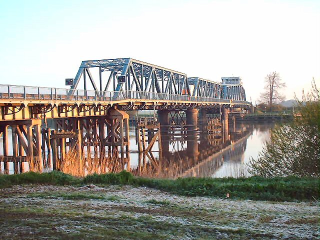
Boothferry Bridge

Boothferry Bridge is a crossing over the River Ouse, between the East Riding and West Yorkshire, England, some 2 miles (3.2 km) north-west of Goole. The...

Boothferry

Boothferry is a village in the East Riding of Yorkshire in England. It is situated on the north bank of the River Ouse where the A614 road crosses the...

Booth, East Riding of Yorkshire

Booth is a hamlet near Goole, in the East Riding of Yorkshire, England. Booth is also known as Boothferry or Boothferry Bridge. == References ==
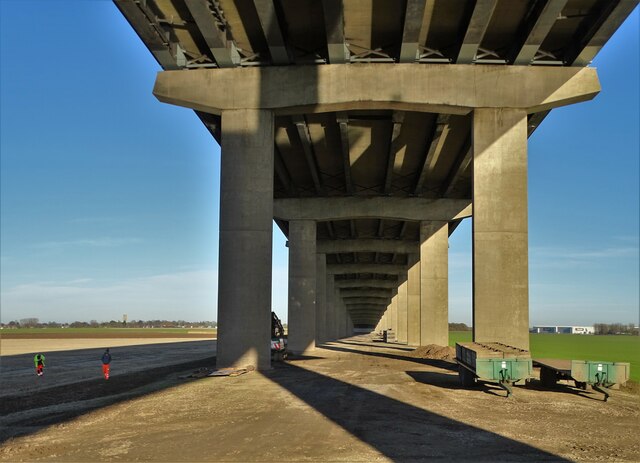
Ouse Bridge (M62)

The Ouse Bridge is a reinforced concrete plate girder bridge that spans River Ouse between Goole and Howden in the East Riding of Yorkshire, England. It...

Boothferry (UK Parliament constituency)

Boothferry was a constituency in Humberside which returned one Member of Parliament (MP) to the House of Commons of the Parliament of the United Kingdom...

West Park, Goole

West Park is an urban park in Goole, East Riding of Yorkshire, England. It was opened in 1923 and is the largest park in the town. == History == The park...

Nearby Amenities

Located within 500m of 53.726592,-0.9071161
Barrier: kissing_gate
Foot: yes
Lat/Long: 53.7240723/-0.9040399
Generator Method: wind_turbine
Generator Output Electricity: yes
Generator Source: wind
Generator Type: horizontal_axis
Power: generator
Source: bing
Lat/Long: 53.7260752/-0.9132311
The data included in this document is from www.openstreetmap.org. The data is made available under ODbL.

Have you been to Aire Mouth?

Leave your review of Aire Mouth below (or comments, questions and feedback).