Aith Voe

Sea, Estuary, Creek in Shetland

Scotland

Aith Voe

Gun emplacement at the summit of Score Hill Score Hill is on Aith Ness at the north of Bressay. All previous photos of this spot (they are worth looking at!) show the gun itself. I therefore assumed, wrongly, that it had been removed between 2013 and 2018, which felt like a rather pointless and expensive operation to me.

However, I soon realised that I was wrong. In this photo we are looking almost straight down the gun barrel! (Of course the barrel had been blocked, not that it could have been used in anger anyway.) Apologies to anyone misled by that error.

Immediately ahead are Inner Score and Outer Score, with the tiny channel (Gloup of the Scores) between them. On the horizon beyond them is Whalsay, with the Out Skerries on the right.

David Purchase
Gun emplacement at the summit of Score Hill Credit: Michael Earnshaw

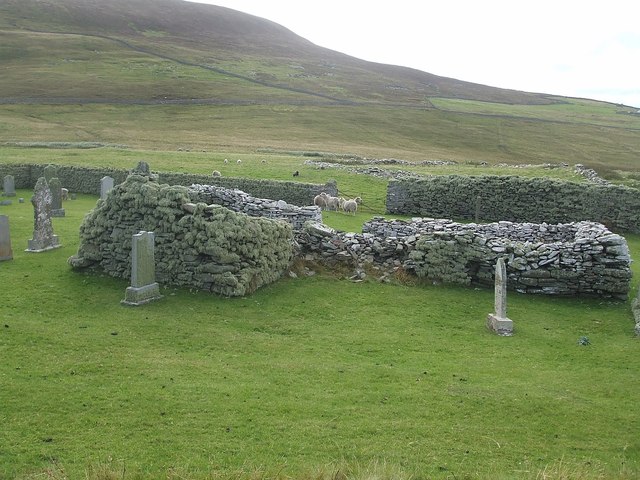
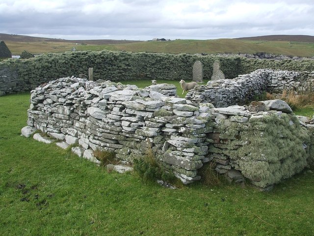
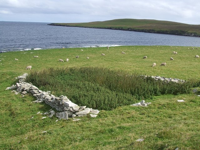
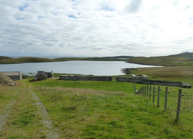
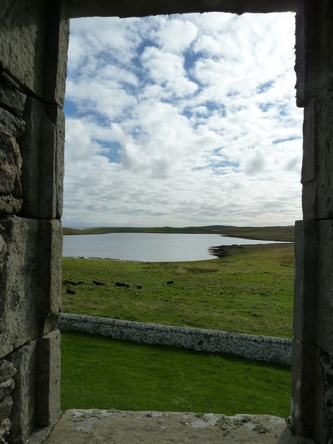
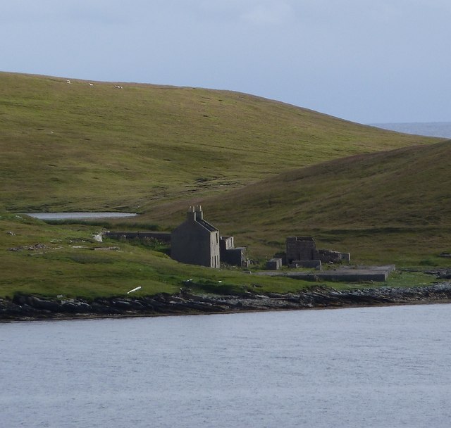
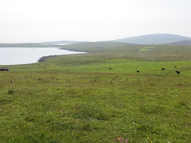
Aith Voe is a picturesque sea inlet located on the west coast of the Shetland Islands, Scotland. As one of the largest voes (sea inlets) in Shetland, it stretches approximately 3 miles inland, branching off from the larger Aith Sound. The voe is surrounded by lush green hills and cliffs, offering a breathtaking scenic view to visitors.

Aith Voe is known for its rich biodiversity, attracting a wide range of marine and bird species. The sheltered waters of the voe provide an ideal habitat for various fish species, such as cod, haddock, and mackerel, making it a popular spot for recreational fishing. The voe is also home to a diverse array of seabirds, including puffins, guillemots, and razorbills, which nest along the cliffs and can be observed during the breeding season.

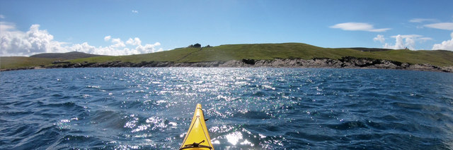
The natural beauty and tranquility of Aith Voe make it a favored destination for outdoor enthusiasts. The calm and clear waters offer opportunities for kayaking, sailing, and even swimming for the more adventurous visitors. Along the shores of the voe, there are several walking trails that allow visitors to explore the surrounding area and appreciate the stunning coastal scenery.

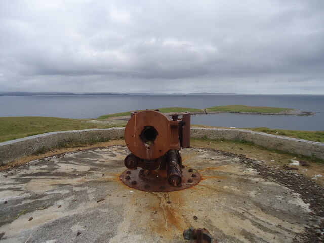
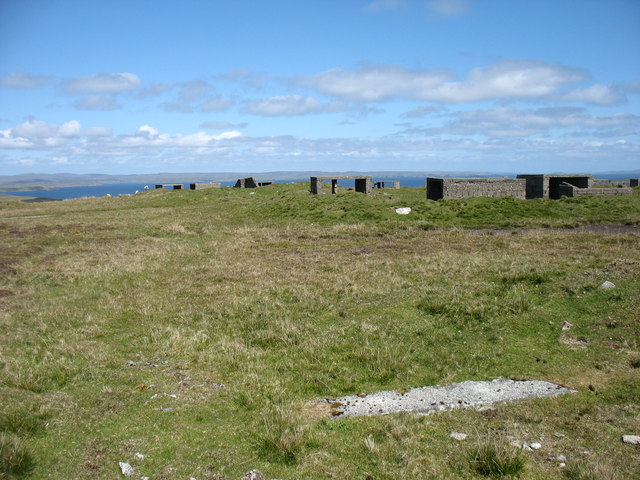
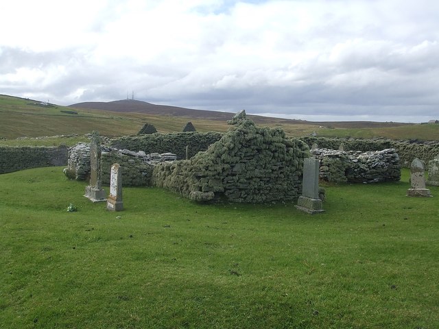
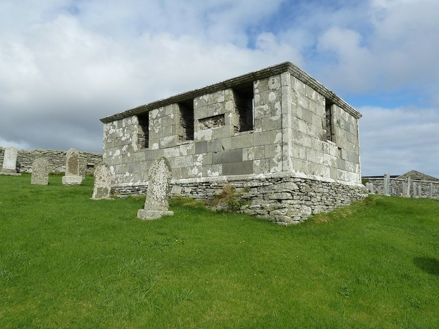
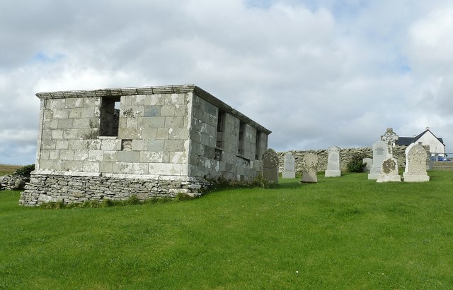
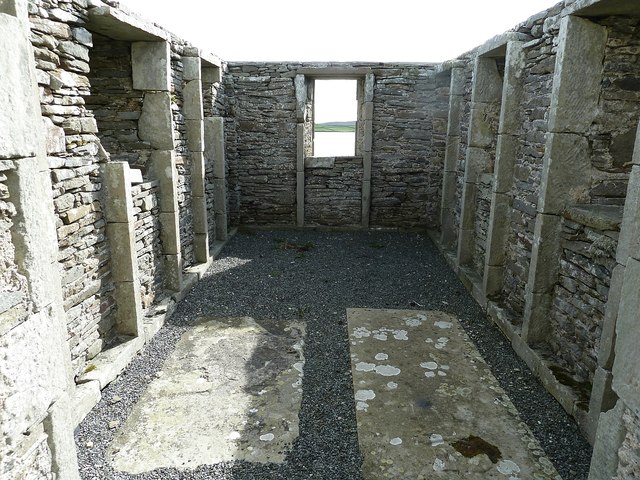
Aith Voe is also of historical significance, with evidence of human settlement dating back thousands of years. Archaeological remains, including ancient settlements and burial sites, have been discovered in the vicinity, providing insights into the early inhabitants of the area.

Overall, Aith Voe is a captivating natural treasure, offering a unique blend of scenic beauty, wildlife, and historical significance for visitors to explore and appreciate.

If you have any feedback on the listing, please let us know in the comments section below.

Aith Voe Images

Images are sourced within 2km of 60.174737/-1.0879355 or Grid Reference HU5043. Thanks to Geograph Open Source API. All images are credited.

Gun emplacement at the summit of Score Hill Score Hill is on Aith Ness at the north of Bressay. All previous photos of this spot (they are worth looking at!) show the gun itself. I therefore assumed, wrongly, that it had been removed between 2013 and 2018, which felt like a rather pointless and expensive operation to me.

However, I soon realised that I was wrong. In this photo we are looking almost straight down the gun barrel! (Of course the barrel had been blocked, not that it could have been used in anger anyway.) Apologies to anyone misled by that error.

Immediately ahead are Inner Score and Outer Score, with the tiny channel (Gloup of the Scores) between them. On the horizon beyond them is Whalsay, with the Out Skerries on the right.

David Purchase
Gun emplacement at the summit of Score Hill
Score Hill is on Aith Ness at the north of Bressay. All previous photos of this spot (they are worth looking at!) show the gun itself. I therefore assumed, wrongly, that it had been removed between 2013 and 2018, which felt like a rather pointless and expensive operation to me. However, I soon realised that I was wrong. In this photo we are looking almost straight down the gun barrel! (Of course the barrel had been blocked, not that it could have been used in anger anyway.) Apologies to anyone misled by that error. Immediately ahead are Inner Score and Outer Score, with the tiny channel (Gloup of the Scores) between them. On the horizon beyond them is Whalsay, with the Out Skerries on the right. David Purchase
The summit of the Hill of Setter, Bressay With the remains of a World War II anti-aircraft battery.
The summit of the Hill of Setter, Bressay
With the remains of a World War II anti-aircraft battery.
Southwest shore, Voe of Cullingsborough Although the Voe of Cullingsborough looks sheltered, there is a low pass through the island of Bressay just to its south and today's southerly wind was being canalised through the gap, giving us the strongest headwind of our day's paddle round Noss. A somewhat unexpected end to a day where we'd anticipated the most challenging conditions to be out on the open coast. However, it's not far to go now - the landing is on the little shingle beach on the left of the photo, which lies just below the end of the public road, and the parked cars of both our group of sea kayakers and another, bigger group, who'd gone round the other way and were not far behind us.
Southwest shore, Voe of Cullingsborough
Although the Voe of Cullingsborough looks sheltered, there is a low pass through the island of Bressay just to its south and today's southerly wind was being canalised through the gap, giving us the strongest headwind of our day's paddle round Noss. A somewhat unexpected end to a day where we'd anticipated the most challenging conditions to be out on the open coast. However, it's not far to go now - the landing is on the little shingle beach on the left of the photo, which lies just below the end of the public road, and the parked cars of both our group of sea kayakers and another, bigger group, who'd gone round the other way and were not far behind us.
Ruins of St Mary's church, Cullingsburgh The ruined village of Cullingsburgh on Bressay has a ruined church. It is set in a walled churchyard which contained several sheep when I visited. Whether the sheep had been intentionally let in to graze the grass of the burial ground, been let in accidentally by earlier visitors, or had worked out a method of getting in here under their own trotter power I have no idea - but they seemed to be trapped within.
Ruins of St Mary's church, Cullingsburgh
The ruined village of Cullingsburgh on Bressay has a ruined church. It is set in a walled churchyard which contained several sheep when I visited. Whether the sheep had been intentionally let in to graze the grass of the burial ground, been let in accidentally by earlier visitors, or had worked out a method of getting in here under their own trotter power I have no idea - but they seemed to be trapped within.
Cullingsburgh - St Mary's and churchyard Part of the former church of St Mary in the abandoned and ruined village of Cullingsburgh on Bressay. Surrounded by gravestones, many of which I'm sure postdate the ruination of the church.
Cullingsburgh - St Mary's and churchyard
Part of the former church of St Mary in the abandoned and ruined village of Cullingsburgh on Bressay. Surrounded by gravestones, many of which I'm sure postdate the ruination of the church.
St Mary's church and churchyard wall, Cullingsburgh Part of the remaining structure of the former church of St Mary in the ruined village of Cullingsburgh with a section of the enclosing churchyard wall seen behind.
St Mary's church and churchyard wall, Cullingsburgh
Part of the remaining structure of the former church of St Mary in the ruined village of Cullingsburgh with a section of the enclosing churchyard wall seen behind.
Traces of an ancient broch, Cullingsburgh This semicircular loop of stones is all that remains of the ancient broch that once stood here at Cullinsburgh. Dating from about 2000 years ago it is  approximately twice as old as the oldest parts of the adjacent ruined church of St Mary. The later building cut across the Pictish remains and very probably stones from the broch were "mined" for use in the construction of the church.
Traces of an ancient broch, Cullingsburgh
This semicircular loop of stones is all that remains of the ancient broch that once stood here at Cullinsburgh. Dating from about 2000 years ago it is approximately twice as old as the oldest parts of the adjacent ruined church of St Mary. The later building cut across the Pictish remains and very probably stones from the broch were "mined" for use in the construction of the church.
View across Gunnista churchyard to Aith Voe Gunnista is a little settlement at the north of the island of Bressay. There is a walled churchyard here for the long vanished St Ola's Church. The graveyard contains a notable mausoleum and gravestones many of them quite recent. Beyond the land can be seen the landward end of Aith Voe, an inlet that curls round southeastwards from the north, and beyond that the land is the southern end of Aith Ness. For photographs of the mausoleum and churchyard, see <a href="https://www.geograph.org.uk/photo/2707684">HU5043 : Churchyard and Mausoleum, Gunnista</a> <a href="https://www.geograph.org.uk/photo/2707683">HU5043 : Gunnista Mausoleum</a>
View across Gunnista churchyard to Aith Voe
Gunnista is a little settlement at the north of the island of Bressay. There is a walled churchyard here for the long vanished St Ola's Church. The graveyard contains a notable mausoleum and gravestones many of them quite recent. Beyond the land can be seen the landward end of Aith Voe, an inlet that curls round southeastwards from the north, and beyond that the land is the southern end of Aith Ness. For photographs of the mausoleum and churchyard, see HU5043 : Churchyard and Mausoleum, Gunnista HU5043 : Gunnista Mausoleum
Gunnista Mausoleum This small mausoleum in the churchyard of the now vanished St Ola's Church was built for the Hendersons of Gardie. St Ola's was the parish church for the island of Bressay until the 1720s when a new church was built at Mail on the west of the island. The old church fell into ruin and was demolished. The mausoleum dates from the C18th and may stand where the old church once stood.
Gunnista Mausoleum
This small mausoleum in the churchyard of the now vanished St Ola's Church was built for the Hendersons of Gardie. St Ola's was the parish church for the island of Bressay until the 1720s when a new church was built at Mail on the west of the island. The old church fell into ruin and was demolished. The mausoleum dates from the C18th and may stand where the old church once stood.
Churchyard and Mausoleum, Gunnista The churchyard of the vanished St Ola's church, once the parish church for the island of Bressay contains the Henderson Mausoleum and a number of more recent headstones. Information about the Hendersons of Gardie here <span class="nowrap"><a title="http://shetlopedia.com/Henderson_of_Gardie_-_Grant%27s_County_Families" rel="nofollow ugc noopener" href="http://shetlopedia.com/Henderson_of_Gardie_-_Grant%27s_County_Families">Link</a><img style="margin-left:2px;" alt="External link" title="External link - shift click to open in new window" src="https://s1.geograph.org.uk/img/external.png" width="10" height="10"/></span>
Churchyard and Mausoleum, Gunnista
The churchyard of the vanished St Ola's church, once the parish church for the island of Bressay contains the Henderson Mausoleum and a number of more recent headstones. Information about the Hendersons of Gardie here LinkExternal link
Inside the Henderson Mausoleum at Gunnista The rectangular mausoleum in the churchyard of the former St Ola's church at Gunnista was built for the Hendersons of Gardie. see <span class="nowrap"><a title="http://shetlopedia.com/Henderson_of_Gardie_-_Grant%27s_County_Families" rel="nofollow ugc noopener" href="http://shetlopedia.com/Henderson_of_Gardie_-_Grant%27s_County_Families">Link</a><img style="margin-left:2px;" alt="External link" title="External link - shift click to open in new window" src="https://s1.geograph.org.uk/img/external.png" width="10" height="10"/></span>
Inside the Henderson Mausoleum at Gunnista
The rectangular mausoleum in the churchyard of the former St Ola's church at Gunnista was built for the Hendersons of Gardie. see LinkExternal link
A tomb with a view A view through the eastern window of the Henderson Mausoleum in the churchyard of the long-demolished church of St Ola at Gunnista on Bressay. Through the window can be seen the landward end of Aith Voe. Information on the Henderson family of Gardie here <span class="nowrap"><a title="http://shetlopedia.com/Henderson_of_Gardie_-_Grant%27s_County_Families" rel="nofollow ugc noopener" href="http://shetlopedia.com/Henderson_of_Gardie_-_Grant%27s_County_Families">Link</a><img style="margin-left:2px;" alt="External link" title="External link - shift click to open in new window" src="https://s1.geograph.org.uk/img/external.png" width="10" height="10"/></span>
A tomb with a view
A view through the eastern window of the Henderson Mausoleum in the churchyard of the long-demolished church of St Ola at Gunnista on Bressay. Through the window can be seen the landward end of Aith Voe. Information on the Henderson family of Gardie here LinkExternal link
Ruin across Aith Voe from Gunnista Looking across Aith Voe from the churchyard at Gunnista, the ruins of a building which I believe was a factory involved in the herring industry. It has a large concrete "courtyard" in front of it, presumably for dealing with the landed catch. Beyond the ruined building can be glimpsed a little of the small Loch of Aithness. It seems there were several quarries on Aith Ness which I think produced slate.
Ruin across Aith Voe from Gunnista
Looking across Aith Voe from the churchyard at Gunnista, the ruins of a building which I believe was a factory involved in the herring industry. It has a large concrete "courtyard" in front of it, presumably for dealing with the landed catch. Beyond the ruined building can be glimpsed a little of the small Loch of Aithness. It seems there were several quarries on Aith Ness which I think produced slate.
Score Hill Score Hill, 66 metres and a P62 hill.  Richard Speirs appears to be having some trouble with the firing pin of this old gun.
Score Hill
Score Hill, 66 metres and a P62 hill. Richard Speirs appears to be having some trouble with the firing pin of this old gun.
Hill of Setter Bagged on the way back from Score Hill with Tricky Speirs.  Heavily modified with wartime buildings but chambered cairn at natural highpoint has escaped.
Name: Hill of Setter
Hill number: 103941
Height: 90m / 295ft
Area: 22: Shetland Islands
Class: 0
Grid ref: HU504421 (est)
Drop: 39m
Col: 51m  HU504409
Hill of Setter
Bagged on the way back from Score Hill with Tricky Speirs. Heavily modified with wartime buildings but chambered cairn at natural highpoint has escaped. Name: Hill of Setter Hill number: 103941 Height: 90m / 295ft Area: 22: Shetland Islands Class: 0 Grid ref: HU504421 (est) Drop: 39m Col: 51m HU504409
View Up Track Towards Bruntland A view up the track to the dwellings at Bruntland.  A good drainage ditch beside the track.
View Up Track Towards Bruntland
A view up the track to the dwellings at Bruntland. A good drainage ditch beside the track.
House And Boat At Aith
Gunnista croftland Northern Bressay.
Gunnista croftland
Northern Bressay.
Show me another place!

Aith Voe is located at Grid Ref: HU5043 (Lat: 60.174737, Lng: -1.0879355)

Unitary Authority: Shetland Islands

Police Authority: Highlands and Islands

What 3 Words

///paddlers.recording.otters. Near Lerwick, Shetland Islands

Nearby Locations

Aith Voe

Related Wikis

Voe of Cullingsburgh

Voe of Cullingsburgh is a large sea loch off the Shetland island of Bressay, voe meaning "sea inlet" in Shetland dialect. The local spelling of the name...

Broch of Cullingsburgh

The Broch of Cullingsburgh is an Iron Age broch located in the Shetland islands. == Location == Located on Bressay, off the east coast of mainland Shetland...

Gardie House

Gardie House is an 18th-century estate house on Bressay in Shetland, Scotland. Located opposite Lerwick, across the Bressay Sound, Gardie is described...

Bressay

Bressay (Scots: Bressa) is a populated island in the Shetland archipelago of Scotland. == Geography and geology == Bressay lies due south of Whalsay, west...

Mareel

Mareel is a multi-purpose entertainment venue located on the waterfront of Lerwick, the capital of Shetland. Opening in 2012, the facility includes a music...

Lerwick and Bressay Parish Church

Lerwick and Bressay Parish Church is the largest Church of Scotland congregation in Shetland, serving the islands' capital Lerwick and the surrounding...

Viking bus station

Viking Bus Station is a bus station in Lerwick, Shetland, Scotland. The station is used both by passengers and for freight, which is transported by bus...
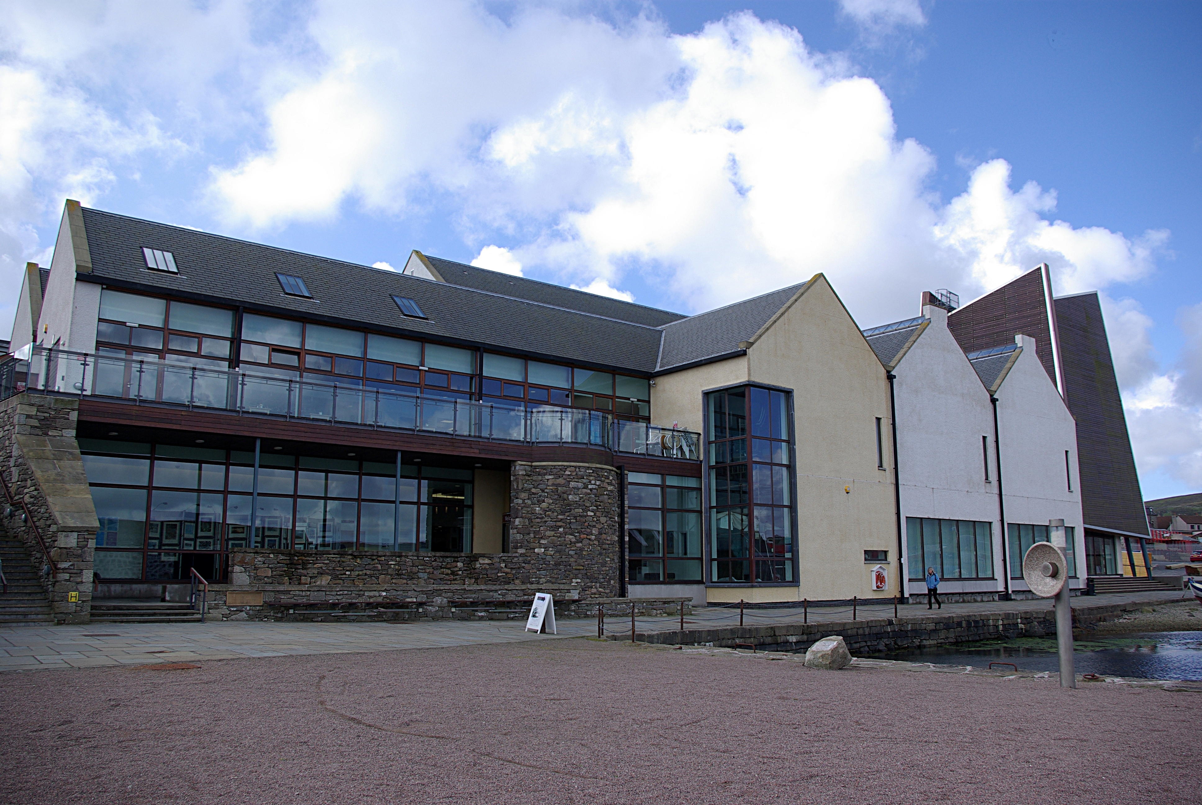
Shetland Museum

The Shetland Museum and Archives is a museum in Lerwick, Shetland, Scotland. The new Shetland Museum at Hay's Dock was officially opened on 31 May 2007...

Have you been to Aith Voe?

Leave your review of Aith Voe below (or comments, questions and feedback).