Penketh Reach

Sea, Estuary, Creek in Cheshire

England

Penketh Reach

Moore Lane Swing Bridge Crosses  the Manchester Ship Canal. Grade II Listed.
Moore Lane Swing Bridge Credit: Arthur C Harris

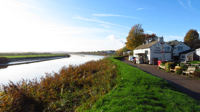
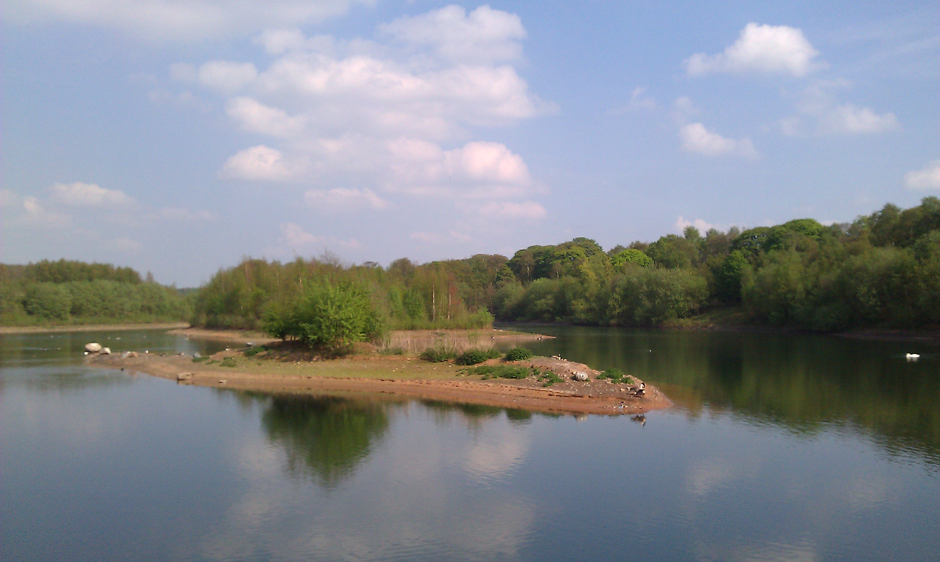
Penketh Reach is a picturesque area located in Cheshire, England, known for its stunning natural beauty and unique geographical features. Situated on the banks of the Mersey Estuary, it encompasses a stretch of the river that flows into the Irish Sea. The reach is characterized by its wide expanse of water, flanked by lush greenery and diverse wildlife.

The Mersey Estuary, which Penketh Reach is a part of, is a tidal estuary formed by the confluence of the River Mersey and the River Irwell. This dynamic ecosystem is influenced by the ebb and flow of the tides, creating a vibrant habitat for numerous species of birds, fish, and mammals. Birdwatchers flock to the area to observe the rich avian diversity, including wading birds, gulls, and terns.

The reach itself is a haven for boating enthusiasts, offering a tranquil setting for sailing, kayaking, and other water-based activities. It also serves as a vital transportation route, with cargo ships and ferries passing through on their way to the nearby ports.

The surrounding landscape of Penketh Reach features rolling hills, woodland areas, and marshes, providing a stunning backdrop for outdoor enthusiasts and nature lovers. The area is home to several nature reserves and walking trails, offering visitors the chance to explore and immerse themselves in its natural wonders.

Overall, Penketh Reach is a hidden gem in Cheshire, offering a unique blend of natural beauty, diverse wildlife, and recreational opportunities. Whether it's admiring the stunning estuary views, exploring the nature reserves, or simply enjoying a peaceful day by the water, this charming area has something to offer for everyone.

If you have any feedback on the listing, please let us know in the comments section below.

Penketh Reach Images

Images are sourced within 2km of 53.375829/-2.6424748 or Grid Reference SJ5786. Thanks to Geograph Open Source API. All images are credited.

Moore Lane Swing Bridge Crosses  the Manchester Ship Canal. Grade II Listed.
Moore Lane Swing Bridge
Crosses the Manchester Ship Canal. Grade II Listed.
Acton Grange Viaduct Dating from 1893, the viaduct carries the LNWR and GWR lines over the Manchester Ship Canal
Acton Grange Viaduct
Dating from 1893, the viaduct carries the LNWR and GWR lines over the Manchester Ship Canal
Boats on Sankey Canal at Fiddler's Ferry
The Ferry Tavern, Fiddler's Ferry
The R Mersey towards Penketh Bank from Fiddler's Ferry
Moore Lane
Moore Lane
Manchester Ship Canal
Swing Bridge over the Manchester Ship Canal
Moss Lane beside the Manchester Ship Canal
Fiddlers Ferry, River Mersey The Ferry Tavern alongside the River Mersey at Fiddlers Ferry, west of Warrington.
Fiddlers Ferry, River Mersey
The Ferry Tavern alongside the River Mersey at Fiddlers Ferry, west of Warrington.
Tadpoles and Pylons A murky pond right on the south edge of this grid square teemed with thousands of tadpoles  which are the black blobs you can see in the brown water. A pylon bringing electricity from Fiddler's Ferry Power Station nearby is reflected in the pond.
Tadpoles and Pylons
A murky pond right on the south edge of this grid square teemed with thousands of tadpoles which are the black blobs you can see in the brown water. A pylon bringing electricity from Fiddler's Ferry Power Station nearby is reflected in the pond.
The Mersey and Fiddler's Ferry Power Station looking WSW from SJ56948670
The Mersey and Fiddler's Ferry Power Station
looking WSW from SJ56948670
Renewable Energy and Fossil Fuel A wind pump supplies electricity in small quantities for a specific, local job whilst the pylon in the background carries electricity generated from the burning of fossil fuel at  Fiddler's Ferry power station nearby. 
Taken looking north from SJ575871
Renewable Energy and Fossil Fuel
A wind pump supplies electricity in small quantities for a specific, local job whilst the pylon in the background carries electricity generated from the burning of fossil fuel at Fiddler's Ferry power station nearby. Taken looking north from SJ575871
Footbridge over A57 A footbridge over the A57, looking east bound and joins the two halves of Sycamore Lane that was bisected by the dual carriageway back in the early seventies.
Footbridge over A57
A footbridge over the A57, looking east bound and joins the two halves of Sycamore Lane that was bisected by the dual carriageway back in the early seventies.
Sankey Station Sankey Station on the Liverpool/Manchester line. Looks like it's undergoing a bit of renovation. At one point the station was being closed but if they are working on it then perhaps its future is assured for now...
Sankey Station
Sankey Station on the Liverpool/Manchester line. Looks like it's undergoing a bit of renovation. At one point the station was being closed but if they are working on it then perhaps its future is assured for now...
The Sloop Inn, Sankey Bridges This is the Sloop Inn along the old Liverpool Road (was the A57 before Sankey Way was constructed).
The Sloop Inn, Sankey Bridges
This is the Sloop Inn along the old Liverpool Road (was the A57 before Sankey Way was constructed).
Trans Pennine Trail, Warrington This is just a small fraction of the Trans Pennine Trail, a footpath that runs from Southport on the west coast to Hornsea on the east coast. This is a view looking in an almost easterly direction.
Trans Pennine Trail, Warrington
This is just a small fraction of the Trans Pennine Trail, a footpath that runs from Southport on the west coast to Hornsea on the east coast. This is a view looking in an almost easterly direction.
Show me another place!

Penketh Reach is located at Grid Ref: SJ5786 (Lat: 53.375829, Lng: -2.6424748)

Unitary Authority: Warrington

Police Authority: Cheshire

What 3 Words

///fines.begins.giant. Near Great Sankey, Cheshire

Related Wikis

Fidlers Ferry & Penketh railway station

Fidler's Ferry & Penketh railway station was on what is now the southwestern edge of Warrington, England. It was located at a point where the St Helens...

Sankey Bridges railway station

Sankey Bridges railway station was in southwestern Warrington, England. It was located immediately west of a swing bridge over the Sankey Canal. The station...

Penketh High School

Penketh High School is a secondary school in Penketh, Warrington. It is a co-educational, non-denominational academy school for 11 to 18 year olds. It...

Moore Nature Reserve

Moore Nature Reserve is a nature reserve in the village of Moore in Halton, Cheshire, England. Created from an area which had included a sand quarry and...

Nearby Amenities

Located within 500m of 53.375829,-2.6424748
Created By: almien_coastlines
Source: PGS
Lat/Long: 53.3742006/-2.6486349
Created By: almien_coastlines
Source: PGS
Lat/Long: 53.3738883/-2.6478624
Created By: almien_coastlines
Source: PGS
Lat/Long: 53.373754/-2.647381
Created By: almien_coastlines
Source: PGS
Lat/Long: 53.3735656/-2.646616
Created By: almien_coastlines
Source: PGS
Lat/Long: 53.3735401/-2.6458883
Created By: almien_coastlines
Source: PGS
Lat/Long: 53.3736476/-2.6453476
Created By: almien_coastlines
Source: PGS
Lat/Long: 53.374002/-2.644808
Created By: almien_coastlines
Source: PGS
Lat/Long: 53.374257/-2.644378
Created By: almien_coastlines
Source: PGS
Lat/Long: 53.374768/-2.643945
Created By: almien_coastlines
Source: PGS
Lat/Long: 53.375279/-2.643513
Created By: almien_coastlines
Source: PGS
Lat/Long: 53.375916/-2.6431331
Created By: almien_coastlines
Source: PGS
Lat/Long: 53.376302/-2.642647
Created By: almien_coastlines
Source: PGS
Lat/Long: 53.3766277/-2.6423521
Created By: almien_coastlines
Source: PGS
Lat/Long: 53.376981/-2.6419658
Created By: almien_coastlines
Source: PGS
Lat/Long: 53.377194/-2.641568
Created By: almien_coastlines
Source: PGS
Lat/Long: 53.3776876/-2.6408672
Created By: almien_coastlines
Source: PGS
Lat/Long: 53.377959/-2.640276
Created By: almien_coastlines
Source: PGS
Lat/Long: 53.378213/-2.639417
Created By: almien_coastlines
Source: PGS
Lat/Long: 53.3783839/-2.6384124
Created By: almien_coastlines
Source: PGS
Lat/Long: 53.378462/-2.637273
Created By: almien_coastlines
Source: PGS
Lat/Long: 53.377048/-2.635358
Created By: almien_coastlines
Source: PGS
Lat/Long: 53.3772063/-2.6358976
Created By: almien_coastlines
Source: PGS
Lat/Long: 53.3773394/-2.6365242
Created By: almien_coastlines
Source: PGS
Lat/Long: 53.3775033/-2.6372709
Created By: almien_coastlines
Source: PGS
Lat/Long: 53.3776569/-2.6380262
Created By: almien_coastlines
Source: PGS
Lat/Long: 53.3775186/-2.6384725
Created By: almien_coastlines
Source: PGS
Lat/Long: 53.3771858/-2.6389274
Created By: almien_coastlines
Source: PGS
Lat/Long: 53.3760389/-2.6389532
Source: PGS
Lat/Long: 53.3749664/-2.6392353
Source: PGS
Lat/Long: 53.3739737/-2.6396039
Source: PGS
Lat/Long: 53.3733295/-2.6401583
Source: PGS
Lat/Long: 53.3728261/-2.6409433
Source: PGS
Lat/Long: 53.3726142/-2.641403
Source: PGS
Lat/Long: 53.3721144/-2.6429328
Source: PGS
Lat/Long: 53.3720847/-2.6438446
Source: PGS
Lat/Long: 53.3720166/-2.6452263
Power: tower
Lat/Long: 53.379053/-2.6460829
The data included in this document is from www.openstreetmap.org. The data is made available under ODbL.

Have you been to Penketh Reach?

Leave your review of Penketh Reach below (or comments, questions and feedback).