Broad Haven

Sea, Estuary, Creek in Pembrokeshire

Wales

Broad Haven

Barafundle Bay Barafundle Beach is a secluded place on the Stackpole Estate accessible by a footpath over the cliffs from Stackpole Quay.
Barafundle Bay Credit: Garth Newton

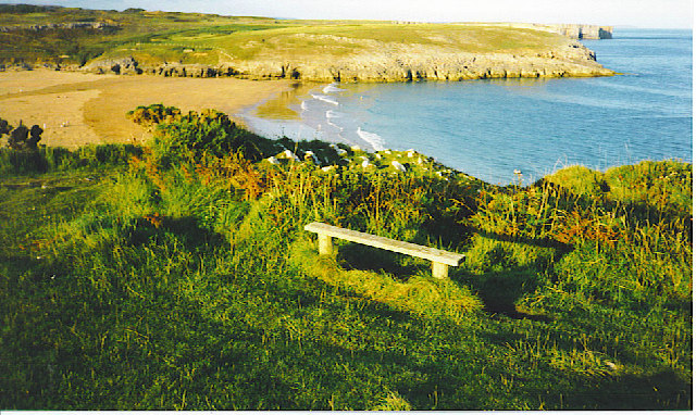
Broad Haven is a picturesque coastal village located in the county of Pembrokeshire, Wales. Situated on the western coast of the country, it boasts a stunning stretch of sandy beach that is popular among locals and tourists alike. The village sits within the Pembrokeshire Coast National Park, a designated Area of Outstanding Natural Beauty, and is surrounded by breathtaking landscapes.

The main attraction of Broad Haven is its beautiful beach, which spans over a mile in length and is backed by impressive sand dunes. The beach offers a variety of activities, including swimming, surfing, and sunbathing. It is also a haven for wildlife, with seabirds often seen soaring above the waves and seals occasionally spotted basking on the shore.

In addition to the beach, Broad Haven is also blessed with a tranquil estuary and creek. The estuary, formed by the confluence of two small rivers, provides a picturesque setting for leisurely walks and birdwatching. The creek, known as Little Haven, is a charming little village located just a short walk away, and is a popular spot for boating and fishing.

Broad Haven itself has a small but vibrant community, with a range of amenities including shops, cafes, and pubs. The village is well-connected, with good road links to nearby towns and attractions. It is also a popular base for exploring the wider Pembrokeshire region, with the famous coastal path running through the village, offering breathtaking views of the rugged coastline.

Overall, Broad Haven is a tranquil coastal village that offers a perfect blend of natural beauty, outdoor activities, and a friendly community, making it an ideal destination for visitors seeking a peaceful seaside retreat.

If you have any feedback on the listing, please let us know in the comments section below.

Broad Haven Images

Images are sourced within 2km of 51.607619/-4.9183999 or Grid Reference SR9893. Thanks to Geograph Open Source API. All images are credited.

Barafundle Bay Barafundle Beach is a secluded place on the Stackpole Estate accessible by a footpath over the cliffs from Stackpole Quay.
Barafundle Bay
Barafundle Beach is a secluded place on the Stackpole Estate accessible by a footpath over the cliffs from Stackpole Quay.
Bosherton Lily Ponds In June this three mile stretch of water is covered with white lilies.
Bosherton Lily Ponds
In June this three mile stretch of water is covered with white lilies.
Bosherston Lakes The lakes, or lily ponds, are part of the National Trust's Stackpole Estate.
Bosherston Lakes
The lakes, or lily ponds, are part of the National Trust's Stackpole Estate.
The bridge at Stackpole Centre The eight arch bridge heading back through Stackpole Park
The bridge at Stackpole Centre
The eight arch bridge heading back through Stackpole Park
Near the Raming Hole to the west of Stackpole Head On the glorious Pembrokeshire Coastal Path
Near the Raming Hole to the west of Stackpole Head
On the glorious Pembrokeshire Coastal Path
Broad Haven, Pembrokeshire Rough seas at Broad Haven, the blocked entrance to Bosherston Lily Ponds
Broad Haven, Pembrokeshire
Rough seas at Broad Haven, the blocked entrance to Bosherston Lily Ponds
Barafundle Bay Photo of Barafundle Bay from the east. This was taken at 10:00 am emphasising the effort it takes to get to this unspoilt beach.
Barafundle Bay
Photo of Barafundle Bay from the east. This was taken at 10:00 am emphasising the effort it takes to get to this unspoilt beach.
Church at Bosherton The church is dedicated to St Michael and All Angels.
Church at Bosherton
The church is dedicated to St Michael and All Angels.
Broad Haven beach Looking NE from the car park walk down to the beach.
Broad Haven beach
Looking NE from the car park walk down to the beach.
Saddle Point and Church Rock. Taken from Broad Haven.
Saddle Point and Church Rock.
Taken from Broad Haven.
Lilies on the Bosherston Ponds. Dammed for Fishing Ponds.
Lilies on the Bosherston Ponds.
Dammed for Fishing Ponds.
The upper bridge at Bosherston Ponds.
Broad Haven. Evening on the Pembroke Coastal Path.
Broad Haven.
Evening on the Pembroke Coastal Path.
Barafundle Bay. Taken from the south. This is a secluded sandy bay, accessible only on foot. It is owned by the National Trust.
Barafundle Bay.
Taken from the south. This is a secluded sandy bay, accessible only on foot. It is owned by the National Trust.
A stack on Stackpole Head. Pembrokeshire Coastal Path scenery.
A stack on Stackpole Head.
Pembrokeshire Coastal Path scenery.
Sandy bay by Stackpole Warren. Taken from the Pembrokeshire Coastal Path.
Sandy bay by Stackpole Warren.
Taken from the Pembrokeshire Coastal Path.
Sea Caves by Stackpole Warren. On the Pembrokeshire Coastal Path.
Sea Caves by Stackpole Warren.
On the Pembrokeshire Coastal Path.
Bridge 8 arch bridge on the Stackpole Estate.
Bridge
8 arch bridge on the Stackpole Estate.
Show me another place!

Broad Haven is located at Grid Ref: SR9893 (Lat: 51.607619, Lng: -4.9183999)

Unitary Authority: Pembrokeshire

Police Authority: Dyfed Powys

What 3 Words

///lights.tarnished.bids. Near Bosherston, Pembrokeshire

Nearby Locations

Broad Haven Church Rock

Related Wikis

Broad Haven South

Broad Haven South is a beach located 1 mile (1.6 km) southeast of Bosherston on the edge of the Stackpole Estate in Pembrokeshire, Wales. Broad Haven...

Bosherston Lakes

Bosherston Lakes or Bosherston Lily Ponds is a lake system with three principal arms. The lakes were created by damming a small river on the Stackpole...

Barafundle Bay

Barafundle Bay (Welsh: Bae Barafundle) is a remote, slightly curved, east-facing sandy beach, near Stackpole Quay in Pembrokeshire, Wales. It is part of...

Bosherston

Bosherston (Welsh: Llanfihangel-clogwyn-gofan, translates to "St Michaels above the cliffs of St Gofan") is a village and parish in Pembrokeshire, Wales...

Nearby Amenities

Located within 500m of 51.607619,-4.9183999
Source: PGS
Lat/Long: 51.6066848/-4.9205742
Source: PGS
Lat/Long: 51.6066028/-4.9226671
Source: PGS
Lat/Long: 51.6096187/-4.9193476
Source: PGS
Lat/Long: 51.6091245/-4.9188428
Created By: dmgroom_coastlines
Source: PGS
Lat/Long: 51.6090186/-4.9185957
Created By: dmgroom_coastlines
Source: PGS
Lat/Long: 51.6083629/-4.9173991
Source: PGS
Lat/Long: 51.6082067/-4.9170453
Source: PGS
Lat/Long: 51.607927/-4.916684
Source: PGS
Lat/Long: 51.6062364/-4.9212307
Toilets
Fee: no
Operator Type: charitable
Operator Wikidata: Q333515
Lat/Long: 51.6075265/-4.9248273
Barrier: kissing_gate
Lat/Long: 51.609928/-4.918991
Phone
Emergency: phone
Lat/Long: 51.6075315/-4.9249136
Saddle Point
Natural: cape
Lat/Long: 51.6082358/-4.9156337
Natural: cave_entrance
Source: Bing
Lat/Long: 51.6064728/-4.9215905
Broad Haven
Natural: bay
Lat/Long: 51.6071559/-4.9189411
Saddle Point
Place: locality
Lat/Long: 51.6071957/-4.9157354
Star Rock
Place: locality
Lat/Long: 51.6060984/-4.9196014
Source: PGS
Lat/Long: 51.6088944/-4.9185536
Bench
Lat/Long: 51.6075208/-4.9248754
The data included in this document is from www.openstreetmap.org. The data is made available under ODbL.

Have you been to Broad Haven?

Leave your review of Broad Haven below (or comments, questions and feedback).